
Lighthouses of Indonesia: Northern Sulawesi (Celebes)
Indonesia has been independent since 1945 after having been the Dutch East Indies for more than 350 years. It is a huge country, stretching along both sides of the Equator for more than 46 degrees of longitude (roughly 5100 km or 3200 miles). Comprised of some 17,000 islands (more than 6000 inhabited islands), it has hundreds of major aids to navigation. This page includes the lighthouses of northern Sulawesi (Celebes), a major island in the northern part of the country.
Shaped like an artistically drawn letter K, Sulawesi consists mostly of four narrow peninsulas. The Makassar Strait separates Sulawesi from Kalimantan (Borneo) to the west. The Celebes Sea is north of the island, the Molucca Sea is to the northeast, the Banda Sea is to the east, the Flores Sea is to the southeast and the Java Sea is to the southwest. This page covers the northern Minahasa Peninsula of the island, including the provinces of Gorontalo and North Sulawesi. North Sulawesi Province also includes the Talaud and Sangihe Islands to the north of Sulawesi; lighthouses of these islands are described on a separate page.
The Indonesian word for a lighthouse is mercusuar. The phrase menara suar, which includes the Arabic word menara, is sometimes used instead. Tanjung and ujung are words for capes, pulau is an island, selat is a strait, karang is a reef, gosong is a shoal or sandbar, teluk is a bay or harbor, and pelabuhan is a port.
Aids to navigation in Indonesia are operated and maintained by the Directorate General of Sea Navigation.
ARLHS numbers are from the ARLHS World List of Lights. Admiralty numbers are from volume F of the Admiralty List of Lights & Fog Signals. U.S. NGA List numbers are from Publication 112. General Sources Online List of Lights - Indonesia - Vol. F
Photos by various photographers posted by Alexander Trabas. Indonesian Lighthouses
Historic postcard views from the collection of Michel Forand. World of Lighthouses - Indonesia
Photos by various photographers available from Lightphotos.net. Sulawesi Map
A useful map from orangesmile.com. 
Bitung Light and VTS, Bitung, January 2016
ex-Google Plus photo by Mayada Limbong
Gorontalo Province North Coast Lighthouses Gorontalo Utara (North Gorontalo) Regency Lighthouses * Anggrek
Date unknown. Active; focal plane 14 m (46 ft); white flash every 2 s. 12 m (39 ft) white barbell-shaped fiberglass tower. Adri Warokka has a photo, Buyung Dharma has an aerial photo, and Google has an indistinct satellite view. Located on the waterfront of Anggrek, a new port in western Gorontolo. Site open, tower closed. Admiralty F2061.9. Karang Otilade
Date unknown. Active; focal plane 12 m (39 ft); white flash every 12 s. 12 m (39 ft) round white concrete tower with gallery, mounted on a square concrete pier. No photo available but Google has a satellite view. Located on a reef about 15 km (9 mi) north of Kwandang. Accessible only by boat. Site open, tower closed. Admiralty F2061.1; NGA 25129. Pulau Hulawa (Lito Lampu)
Date unknown. Active; focal plane 40 m (131 ft); white flash every 3 s. 25 m (82 ft) skeletal tower, painted white. No photo available but Bing has a satellite view. Located on an island off the north coast of Sulawesi, about 25 km (15 mi) north of Malingkapoto. Accessible only by boat. Site status unknown. Admiralty F2060; NGA 25128.
North Sulawesi Province: Minahasa Peninsula North Coast Lighthouses North Sulawesi (Sulawesi Utara) Province includes the final third of the sinuous Minahasa Peninsula plus the Sangihe (Sangir) Islands, a chain that stretches north almost to Mindanao in the Philippines. The islands separate the Celebes Sea on the west from the Molucca Sea on the east.
Bolaang Mongondow Utara (North Bolaang Mongondow) Regency Lighthouses
Pulau Bongkil (Bangkil, Bangkit)
Date unknown. Active; focal plane 17 m (56 ft); white flash every 5 s. 10 m (33 ft) round white fiberglass tower mounted on a platform supported by piles. No photo available but Google has a satellite view. Located on a small island about 16 km (10 mi) off the coast at the border between Gorontalo and North Sulawesi provinces. Accessible only by boat. Site open, tower closed. Admiralty F2062.5; NGA 25134. * Tanjung Sidupa
Date unknown. Active; focal plane about 16 m (52 ft); light characteristic unknown. Approx. 13 m (43 ft) square white skeletal tower mounted on a 1-story white equipment building. Asy-syura Ailani Setyawan has a view from the harbor (a portion is seen at right) and Google has a street view and an indistinct satellite view. Located on the waterfront of Tanjung Sidupa. Site open, tower closed. Admiralty F2062.8.
Bolaang Mongondow Regency Lighthouses Pulau Tikus
Date unknown. Active; focal plane 15 m (49 ft); white flash every 3 s. 15 m (49 ft) round white fiberglass tower mounted on a square platform supported by piles. No photo available but Google has a satellite view. Located on a reef in an estuary entrance off the ferry port of Labuan Uki. Accessible only by boat. Site open, tower closed. Admiralty F2063.3; NGA 25137. Tanjung Lobu
Date unknown. Active; focal plane 24 m (79 ft); white flash every 5 s. 10 m (33 ft) round white fiberglass tower. 1-story keeper's cottage or equipment building. No photo available but Google has a satellite view. Site open, tower closed. Admiralty F2063.8; NGA 25139. 
Tanjung Sidupa Light, Tanjung Sidupa, June 2017
ex-Google Plus photo by Asy-syura Ailani Setyawan
Minahasa Selatan (South Minahasa) Regency Lighthouses Tanjung Sangket
Date unknown. Active; focal plane about 15 m (49 ft); light characteristic unknown. Approx. 15 m (49 ft) round white fiberglass tower mounted on a platform supported by piles. No photo available but Google has a satellite view. Located off the low cape about 5 km (3 mi) northwest of Amurang. Accessible only by boat. Site open, tower closed. Admiralty F2063.84. * Amurang
Date unknown. Active; focal plane about 16 m (52 ft); light characteristic unknown. Approx. 13 m (43 ft) square white skeletal tower mounted on a 1-story white equipment building. Eric Pajow has a closeup photo, another photo is available, and Google has an indistinct satellite view. Located on the waterfront of the Amurang ferry terminal. Site open, tower closed. Admiralty F2063.85. Tetapaan
Date unknown. Active; focal plane 12 m (39 ft); red flash every 3 s. 12 m (39 ft) red fiberglass tower on a square platform suported by piles. No photo available but Gooogle has a satellite view. Located at the western edge of Pulau Tetapaan, where it marks the northern entrance to Amurang Bay about 15 km (9 mi) northwest of the town. Accessible only by boat. Site open, tower closed. Admiralty F2064.4; NGA 25142.
Manado City Lighthouses Manado is the capital of North Sulawesi and the second largest city of Sulawesi, after Makassar, with a population of about 450,000.
*** Manado (2?)
Date unknown. Active; focal plane 32 m (105 ft); white light, 2 s on, 6 s off. Lantern mounted atop a tall tower. Walter Mosca's photo is at right, Moch Hanggoro has a closeup photo and a good view, and Google has a street view and a satellite view. NGA descibes this light as a 12 m (39 ft) skeletal tower. Located on Kampus Unsrat Street in downtown Manado. Site open, and visitors can take in the view from the gallery just below the light tower. Admiralty F2066; NGA 25144. Manado South Mole
Date unknown. Active; focal plane 12 m (39 ft); green flash every 3 s. 10 m (33 ft) round barbell-shaped green fiberglass tower. A photo is available and Google has a street view but only a fuzzy satellite view. Located on the south mole at the entrance to the ferry and small boat harbor of Manado. Site and tower closed, but the light is easy to see from the harbor bridge. Admiralty F2068; NGA 25148. Manado North Mole
Date unknown. Active; focal plane 12 m (39 ft); red flash every 3 s. 10 m (33 ft) round barbell-shaped red fiberglass tower. Moch Hanggoro has a photo and Google has a street view but only a fuzzy satellite view. Located on the north mole at the entrance to the ferry and small boat harbor of Manado. Site and tower closed, but the light is easy to see from the harbor bridge. Admiralty F2070; NGA 25152. Tanjung Pisok
Date unknown. Active; focal plane 10 m (33 ft); red flash every 3 s. 10 m (33 ft) red fiberglass tower mounted on a square platform supported by piles. No photo available but Google has a satellite view. Located off a cape about 8 km (5 mi) north of the Manado waterfront. Accessible only by boat. Site open, tower closed. Admiralty F2070.3. 
Manado Light, Manado, November 2012
Flickr photo copyright Walter Mosca; used by permission
Minahasa Utara (North Minahasa) Regency Lighthouses Pulau Manterawu
2006. Active; focal plane 50 m (164 ft); two white flashes every 10 s. 40 m (131 ft) "white tower," probably skeletal. No photo available and the tower may be too new to appear in Google's satellite view. Located on an island about 30 km (19 mi) west of Tanjung Arus and 40 km (25 mi) north of Manado. Accessible only by boat. Site status unknown. Admiralty F2070.5; NGA 25156.2. Tanjung Tarabitan (Torowitan)
Date unknown. Active; focal plane about 18 m (59 ft); light characteristic unknown. Approx. 18 m (59 ft) tower on a square platform supported by piles. No photo available but Google has a satellite view. Located off the northwestern side of Tanjung Tarabitan, the northernmost point of Sulawesi. Accessible only by boat. Site open, tower closed. Admiralty F2070.8. Tanjung Arus (Pulau Talisei, Talise)
Date unknown (station established 1910). Active; focal plane 108 m (354 ft); white flash every 5 s. 20 m (66 ft) white iron skeletal tower. No photo available but Google has a satellite view of the station. The original lighthouse was an octagonal pyramidal skeletal tower with lantern and gallery, and this lighthouse may still be standing. Tanjung Arus is the extreme northeastern tip of Sulawesi, at the end of the Minahasa Peninsula. The lighthouse is not on the mainland cape but on the northern tip of Pulau Talisei (Talise), an island off the cape, about 50 km (30 mi) northeast of Manado. Accessible only by boat. Site status unknown. ARLHS IDO-290; Admiralty F2072; NGA 25156.
North Sulawesi Province: Minahasa Peninsula East Coast Lighthouses Bitung City Lighthouses Bitung is a city of nearly 200,000 residents at the eastern tip of the Minahasa Peninsula. Pulau Lembeh, an island 25 km (15 mi) long but only 2 km (1.25 mi) wide over most of its length, is parallel to the coast opposite Bitung. The Lembeh Strait separates the island from the Bitung waterfront. Selat Lembeh (Tanjung Batuangus, Lembeh Strait)
Date unknown. Active; focal plane 15 m (49 ft); green flash every 3 s. 14 m (46 ft) square pyramidal skeletal tower mounted on a square platform on a rock. No photo available, but Google has an indistinct satellite view. Located on the west side of the northern entrance to the narrow Lembeh Strait. Accessible only by boat. Site open, tower closed. Admiralty F2077; NGA 25158. Batukapal (Batu Kapal)
Date unknown. Active; focal plane 35 m (115 ft); white flash every 4 s. Approx. 9 m (30 ft) round hourglass-shaped white concrete tower. No photo available but Bing has a satellite view. Pulau Lembeh is a long, narrow island off the east side of Tanjung Arus. This light is atop a steep rocky islet off the northeastern tip of Pulau Lembeh, about 20 km (13 mi) northeast of Kota Bitung. Accessible only by boat. Site status unknown. Admiralty F2079.57; NGA 25157.
Pulau Susulina
Date unknown. Active; focal plane 25 m (82 ft); white light, 3 s on, 3 s off. Described only as a "white beacon" by NGA; Google's satellite view shows a white fiberglass tower. Located on a tiny island just off the southeast side of Pulau Lembeh. Site status unknown. Admiralty F2079.55; NGA 25162. Karang Napokering (Pulau Lembah Southwest)
Date unknown. Active; focal plane 17 m (56 ft); two green lights every 10 s. 17 m (56 ft) round hourglass-shaped tower standing on a square platform supported by four piles. Entire lighthouse is green. Semuel Muhaling's photo is at right and Google has a satellite view. Located on the west (outside) edge of a reef off the southwestern tip of Pulau Lembah, marking the south entrance to the Lembah Strait. Accessible only by boat. Site open, tower closed. Admiralty F2079.5; NGA 25164. Tanjung Labuan Kompeni (Compenie)
Date unknown. Active; focal plane 58 m (190 ft); three white flashes every 15 s. 10 m (33 ft) round white fiberglass tower. No photo available but Google has a satellite view. Located on a promontory of Pulau Lembeh opposite the Bitung waterfront. Site status unknown. Admiralty F2079; NGA 25172. Selat Lembeh (Lembeh Strait)
Date unknown. Active; focal plane 18 m (59 ft); red flash every 3 s. 15 m (49 ft) "red and white beacon" mounted on a platform supported by piles. No photo available but Bing has an indistinct satellite view. Located on Pulau Satu, a tiny island off the west side of Pulau Lembeh northeast of Bitung. Accessible only by boat. Site open, tower closed. Admiralty F2078; NGA 25160. 
Karang Napokering Light, Bitung, December 2008
ex-Panoramio photo copyright Semuel Muhaling; permission requested
* Bitung
Date unknown. Active; focal plane about 25 m (82 ft); light characteristic unknown. Approx. 22 m (72 ft) square cylindrical skeletal tower mounted atop the a square VTS (harbor control) tower. Mayada Limbong's closeup photo is at the top of this page and Google has a street view and an indistinct satellite view. Located at the south end of the main wharf at Bitung. Site open, tower closed. Admiralty F2078.8.
Minahasa Regency Lighthouses Lilang
Date unknown. Active; focal plane 70 m (230 ft); white flash every 3 s. 30 m (98 ft) skeletal tower with gallery, painted white. Google has a street view and a satellite view. Located at Lilang, on the east coast of the Minahasa Peninsula about 30 km (19 mi) southeast of Manado. Site status unknown. ARLHS IDO-159; Admiralty F2079.6; NGA 25168. Pulau Pakolor
Date unknown. Active; focal plane 126 m (413 ft); white flash every 4.5 s. Approx. 40 m (131 ft) tapered square skeletal tower with lantern and gallery, painted white. Several photos are available and Bing has a good satellite view of the station. This unusually high light has a listed range of 50 km (30 mi). Located on a small island off the east coast of the peninsula about 55 km (35 mi) southwest of the Lembah Strait entrance. Accessible only by boat. Site status unknown. ARLHS IDO-176; Admiralty F2079.7; NGA 25169.
Bolaang Mongondow Timur (East Bolaang Mongondow) Regency Lighthouse Pulau Pondang (Pulau Pardana)
Date unknown (station established 1912). Active; focal plane 73 m (240 ft); white flash every 4 s. 22 m (72 ft) skeletal tower, painted white. An aerial view is available and Google has an indistinct satellite view. Located on a small island just offshore on the northern entrance to the Gulf of Tomini from the Molucca Sea. Accessible only by boat. Site status unknown. ARLHS IDO-233; Admiralty F2082; NGA 25228.
Bolaang Mongondow Regency Lighthouse * Taboyangan (Torosik)
Date unknown. Active; focal plane about 17 m (56 ft); light characteristic unknown. Approx. 14 m (46 ft) square white skeletal tower. The tower is partially obscured in a 2018 photo of the harbor entrance and Google has an indistinct satellite view. Located at a small harbor on the north coast of the Gulf of Tomini about 40 km (25 mi) south of Kotamobagu. Site open, tower closed. Admiralty F2082.5.
Gorontalo Province South Coast Lighthouses Gorontalo City Lighthouses The provincial capital of Gorontalo is a city of about 180,000 residents.
* Pelabuhan Gorontalo
Date unknown. Active; focal plane about 18 m (59 ft); light characteristic unknown. Approx. 15 m (49 ft) square white skeletal tower. Nurulhaqi Asri has a view from the sea and Google has a closeup street view and an indistinct satellite view. Located at the Gorontalo ferry terminal. Site open, tower closed. Not listed by the Admiralty. Gorontalo (2?)
2016. Active; focal plane 37 m (121 ft) (?); white flash every 5 s. Approx. 25 m (82 ft) octagonal concrete tower with lantern and gallery. Ardin Yeyen has a December 2016 view from the sea (a portion is seen at right), Abdul Aziz also has a view from the sea, and Google has a street view and a satellite view. This light is still described by the Admiralty and the NGA as a 6 m (20 ft) white skeletal tower. Almost certainly the new light has a higher focal plane. Located on a promontory on the east side of the approach to Gorontalo. Site status unknown. Admiralty F2083; NGA 25232. * Teluk Gorontalo ("Harbormaster's Office") (2?)
Date unknown. Active; focal plane 20 m (66 ft); white flash every 3 s. Approx. 16 m (52 ft) round barbell-shaped white tower mounted on a square platform supported by piles. Google has a closeup street view, Irfan Ali has a view from the sea, Marwan Saleh has a view showing this light on the left and the Gorontalo lighthouse on the right, and Google has a satellite view. Apparently the light was formerly on one of the neighboring buildings; it's not clear if one of them is currently the harbormaster's office. Located at the quay on the east side of the narrow entrance to Gorontalo harbor. Site open, tower closed. Admiralty F2083.3; NGA 25234. 
Gorontalo Light, Gorontalo, December 2016
ex-Google Plus photo by Ardin Yeyen
Boalemo Regency Lighthouses Pulau Mohupombodaa
Date unknown. Active; focal plane about 18 m (59 ft); light characteristic unknown. Approx. 18 m (59 ft) square skeletal tower, probably painted white, mounted on a square platform supported by piles. No photo available but Google has a fuzzy satellite view. Located on a reef about 3 km (1.8 mi) south of the entrance to the harbor of Tilamuta, the capital of the regency. Accessible only by boat. Site open, tower closed. Admiralty F2083.7. Tilamuta Reef
Date unknown. Active; focal plane about 18 m (59 ft); light characteristic unknown. Approx. 18 m (59 ft) square skeletal tower, probably painted green, mounted on a square platform supported by piles. Qyara Pramudhita has a distant sea view and Google has a satellite view. Located on a reef on the east side of the entrance to the harbor of Tilamuta. Accessible only by boat. Site open, tower closed. Admiralty F2083.8. Pulau Tapatada
Date unknown. Active; focal plane about 18 m (59 ft); light characteristic unknown. Approx. 18 m (59 ft) square skeletal tower, probably painted red, mounted on a square platform supported by piles. Qyara Pramudhita has a very distant sea view and Google has a satellite view. Located on a reef on the west side of the entrance to the harbor of Tilamuta. Accessible only by boat. Site open, tower closed. Admiralty F2083.9.
Information available on lost lighthouses:
Notable faux lighthouses:
Lighthouses of Indonesia: Northeastern Sulawesi (Celebes)
Indonesia has been independent since 1945, after having been the Dutch East Indies for more than 350 years. It is a huge country, stretching along both sides of the Equator for more than 46 degrees of longitude (roughly 5100 km or 3200 miles). Comprised of some 17,000 islands (more than 6000 inhabited islands), it has hundreds of major aids to navigation. This page includes the lighthouses of the northeastern portion of Sulawesi (Celebes), a major island in the northern part of the country.
Shaped like an artistically drawn letter K, Sulawesi consists mostly of four narrow peninsulas. The Makassar Strait separates Sulawesi from Kalimantan (Borneo) to the west. The Celebes Sea is north of the island, the Banda Sea is to the east and southeast, and the Flores Sea is on the south. Makassar, also called Ujung Pandang, is the major port. This page includes lighthouses on the east side of the island in Sulawesi Tengah (Central Sulawesi) Province. The province also has a short coast on the west side of the island; lighthouses on that coast are described on the Western Sulawesi page.
The Indonesian word for a lighthouse is mercusuar. The phrase menara suar, which includes the Arabic word menara, is sometimes used instead. Pulau is an island and karang is a reef.
Aids to navigation in Indonesia are operated and maintained by the Directorate General of Sea Navigation.
ARLHS numbers are from the ARLHS World List of Lights. Admiralty numbers are from volumes F and Q of the Admiralty List of Lights & Fog Signals. U.S. NGA List numbers are from Publication 112. General Sources Online List of Lights - Indonesia - Vol. F and Vol. Q
Coming soon: photos by various photographers posted by Alexander Trabas. Indonesian Lighthouses
Historic postcard views from the collection of Michel Forand. World of Lighthouses - Indonesia
Photos by various photographers available from Lightphotos.net. 
Ampana Light, Ampana, November 2017
Google Plus photo by Arlin Windaryanti
Parigi Moutong Regency Lighthouses Note: Parigi Moutong is a narrow coastal regency that curves in a semicircle around the west end of the Gulf of Tomini, the gulf separating the Minnehasa (North) Peninsula and the East Peninsula of Sulawesi. Pulau Panabean
Date unknown. Active; focal plane 31 m (102 ft); two white flashes every 8 s. No description given, but since the islet is quite low a tall skeletal tower would be required. No photo available but Bing has a satellite view. Located on a dangerous reef off the north coast of the Gulf of Tomini. Accessible only by boat. Site open, tower closed. Admiralty F2086.5; NGA 25238. * Tomini
Date unknown. Active; focal plane 14 m (46 ft); two white flashes every 8 s. Approx. 12 m (39 ft) square skeletal tower. Google has a street view and a satellite view. Located in the village of Tomini on the northwestern coast of the Gulf. Site open, tower closed. Admiralty F2087; NGA 25237. Karang Rode Loji
Date unknown. Active; focal plane about 14 m (46 ft); light characteristic unknown. Approx. 14 m (46 ft) skeletal tower mounted on a platform supported by piles. No photo available but Bing has a satellite view. Located on a reef about 8 km (5 mi) northeast of Parigi. Accessible only by boat. Site open, tower closed. Admiralty Q2076.5. * Parigi (Logi) (2)
Date unknown. Active; focal plane about 32 m (105 ft); white flash every 7 s. Approx. 30 m (98 ft) square white skeletal tower. The tower is seen at the far left in Muh Fadjar's photo and Google has a satellite view. NGA lists a 7 m (23 ft) tower said to be "on the beach." Located behind the ferry terminal at Parigi, the regency capital, on the southwestern shore of the Gulf of Tomini. Site open, tower closed. Admiralty Q1576; NGA 25240.
Poso Regency Lighthouse * Poso
Date unknown. Active; focal plane 16 m (52 ft); white light, 2 s on, 1 s off. 15 m (49 ft) square white skeletal tower. Google has a street view and a satellite view. Located at the ferry terminal at Poso, a town of about 40,000 residents and an important regional port at the southwestern corner of the Gulf of Tomini. Site open, tower closed. Admiralty Q1574; NGA 25248.
Tojo Una-Una Regency Lighthouses * Ampana
Date unknown. Active; focal plane about 14 m (46 ft); white light, characteristic unknown. Approx. 12 m (39 ft) square white skeletal tower. Arlin Windaryanti has a photo (a portion appears at the top of this page), and Google has an indistinct satellite view. Located on the quay at Ampana, a town on the south shore of the Gulf of Tomini. Site open, tower closed. Admiralty Q1573. Pulau Una-Una
Date unknown. Active; focal plane 13 m (43 ft); white flash every 3 s. Approx. 10 m (33 ft) square white skeletal tower. No photo available, but Google has a distant satellite view. Una-Una is an isolated volcanic island north of the Togian Islands in the Gulf of Tomini; the Colo volcano that forms the island erupted in 1983. Located at the foot of the pier at the settlement on the east side of the island. Site open, tower closed. Admiralty Q1577; NGA 25238.5. * Wakai
Date unknown. Active; focal plane about 16 m (52 ft); white light, characteristic unknown. Approx. 14 m (46 ft) square white skeletal tower mounted on a square white 1-story equipment building. Edi Yamin has a 2018 view, the top of the tower is seen over the building in Lasahido Saleh's photo, Daniel van Hauten has a fuzzy street view, and Google has a satellite view. Located on the quay at Wakai, a fishing port at the northeastern corner of Pulau Batudaka, the westernmost of the Togian Islands. Site open, tower closed. Admiralty Q1579.
Pulau Bukabuka
Date unknown. Active; focal plane 15 m (49 ft); white flash every 7 s. Approx. 12 m (39 ft) square white skeletal tower. No photo available but Bing has a satellite view. Located on the northern tip of Pulau Bukabuka, an island midway between the mainland and the western end of the Togian Islands. Site status unknown. Admiralty Q1572.7; NGA 25261. Tanjung Komali (Komnali)
Date unknown. Active; focal plane 50 m (164 ft); two white flashes every 8 s. Described only as a "white beacon." No photo available, and the light is not seen in Bing's satellite view of the cape. This light guides vessels entering the Gulf of Tomini from the south. Located on the northwestern tip of Pulau Waleabahi, the easternmost of the Togian Islands. Site status unknown. Admiralty Q1580; NGA 25262.
Banggai Regency Lighthouses * Bunta
Date unknown. Active; focal plane 16 m (52 ft); white light, pattern unknown. 15 m (49 ft) square white skeletal tower. Syahir Ihwar has a closeup photo (also seen at right) and Google has a distant satellite view. Located at the ferry terminal at Bunta, a town on the mainland opposite the Togian Islands. Site open, tower closed. Admiralty Q1572.6. Selat Walera (Walera Strait)
Date unknown. Active; focal plane 19 m (62 ft); three white flashes every 20 s. 13 m (43 ft) square white skeletal tower mounted on a platform supported by piles. No photo available but Bing has a satellite view. This light guides vessels in a narrow passage through a reef connecting the southeast end of the Togian Islands and the mainland. Accessible only by boat. Site open, tower closed. Admiralty Q1572; NGA 25260. Pagimana (?)
Date unknown. Active; focal plane 40 m (131 ft); two white flashes every 8 s. Approx. 25 m (82 ft) square skeletal tower. Google has a street view and a satellite view. This appears to be an appropriate tower for this light, although it does not match the location listed by the Admiralty. Located on a bluff nehind the waterfront of Pagimana. Site status unknown. Admiralty Q1572.4; NGA 25258.  Bunta Bunta Light, Bunta, May 2017
Google Maps photo by Syahir Ihwar
Pagimana Range Front
Date unknown. Active; foal plane about 14 m (46 ft); light characteristic unknown. Approx. 14 m (46 ft) square skeletal tower mounted on a platform supported by piles. Seen in the distance at the right edge of a photo by Jemmy Dimitrius; Bing has a satellite view. This appears to be an approach range for Pagimana. Located on a shoal about 400 m (1/4 mi) off the ferry port at Pagimana. Accessible only by boat. Site open, tower closed. Pagimana Range Rear
Date unknown. Active; foal plane about 21 m (69 ft); light characteristic unknown. Approx. 21 m (69 ft) square skeletal tower mounted on a platform supported by piles. Seen in the foreground at the right edge of a photo by Jemmy Dimitrius; Bing has a satellite view. Located on a shoal just off the waterfront at Pagimana. Accessible only by boat. Site open, tower closed. * Dermaga Pagimana
Date unknown. Active; focal plane about 16 m (52 ft); white light, characteristic unknown. Approx. 14 m (46 ft) square white skeletal tower mounted on a square white 1-story equipment building. Ronald Rumampuk has a street view and Google has an indistinct satellite view. The Admiralty lists this light as "Kr Pagimana," probably a misprint for "Dr Pagimana." Dermaga means "dock." Located behind the ferry terminal at Pagimana. Site open, tower closed. Admiralty Q1572.5; NGA 25248.5. Pulau Pasir
Date unknown. Active; focal plane 15 m (49 ft); white flash every 6 s. 15 m (49 ft) square skeletal tower on a platform supported by piles. No photo available but Bing has a satellite view. The light and the next one guide vessels around the end of the East Peninsula of Sulawesi. Located on a reef about 25 km (15 mi) north of the east end of the peninsula. Accessible only by boat. Site open, tower closed. Admiralty Q1571.5; NGA 25260.2. Pulau Sendiri
Date unknown. Active; focal plane 15 m (49 ft); two white flashes every 6 s. 15 m (49 ft) "white beacon," probably a square skeletal tower on a platform supported by piles. No photo available and the light is not seen in Bing's satellite view of the reef. The light and the previous one guide vessels around the end of the East Peninsula of Sulawesi. NGA misspells the name as Sensiri. Located on a reef abour 15 km (9 mi) north of the east end of the peninsula and 15 km (9 mi) east of Pulau Pasir. Accessible only by boat. Site open, tower closed. Admiralty Q1571; NGA 25260.5.
Luwuk North
Date unknown. Active; focal plane 18 m (59 ft); white flash every 5 s. 18 m (59 ft) square white skeletal tower mounted on a platform supported by piles. This light is in the foreground of Shen Chen's photo and Widdy Rachman's similar photo and Google has a fuzzy satellite view. Chen's photo is at right. Luwuk is the capital of Banggai Regency and a city of about 60,000 residents, located on the south side of the eastern peninsula of Sulawesi across the Peleng Strait from Pulau Peleng. Located just offshore on the north (starboard) side of the entrance to Lalong Bay, the city's harbor. Accessible only by boat but there are good views from shore. Site open, tower closed. Admiralty Q1566; NGA 25252. Luwuk South (Tanjung Tumbuk) (2?)
Date unknown. Active; focal plane 10 m (33 ft); white flash every 3 s. 10 m (33 ft) square red skeletal tower mounted on a platform supported by piles. This light is in the background of Shen Chen's photo and Widdy Rachman's similar photo and Google has a satellite view. NGA lists a 10 m (33 ft) tower. Located just offshore on the south (port) side of the entrance to the harbor. Accessible only by boat but there are good views from shore. Site open, tower closed. Admiralty Q1566.4; NGA 25257. Mondono (Mendono)
Date unknown. Active; focal plane 13 m (43 ft); white flash every 4 s. 13 m (43 ft) square white skeletal tower mounted on a platform supported by piles. No photo available but Google has a fuzzy satellite view. Located just off a promontory about 25 km (15 mi) southwest of Luwuk. Accessible only by boat but there must be good views from shore. Site open, tower closed. Admiralty Q1565.5; NGA 25249. 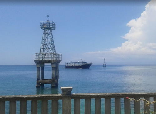
Luwuk North (left) and South Lights, Luwuk, March 2017
Google Maps photo by Shen Chen
* Tangkiang
Date unknown. Active; focal plane about 15 m (49 ft); white light, characteristic unknown. Approx. 13 m (43 ft) square white skeletal tower mounted on a square white 1-story equipment building. The light is at the far right in Radita Kurniawan's photo, Eric Pajow has a similar photo, and Google has an indistinct satellite view. Located on the quay at Tangkiang, a small port about 40 km (25 mi) southwest of Luwuk. Site open, tower closed. Admiralty Q1565.4.
Kepulauan Banggai (Banggai Islands) Regency Lighthouses Note: The Banggai Islands are an archipeligo off the south side of Sulawesi's East Peninsula; the oddly-shaped Pulau Peleng is by far the largest of the islands. The Peleng Strait (Selat Peleng) separates the islands from the Peninsula. Tanjung Kembani
Date unknown. Active; focal plane 22 m (72 ft); white flash every 10 s. 20 m (66 ft) "white beacon," probably a skeletal tower. No photo available but Bing has a satellite view. Located on the southern tip of Peleng. Site status unknown. Admiralty Q1565; NGA 25274.3. Karang Thames (Thames Reef)
Date unknown. Active; focal plane 14 m (46 ft); red light, 1.5 s on, 2.5 s off. 14 m (46 ft) tower (probably skeletal) mounted on a platform supported by piles. No photo available and Google's satellite view has only a blurry spot for the reef. Located about 15 km (9 mi) southwest of Pulau Peland in the southern entrance to the Pelang Strait. Accessible only by boat. Site appears open, tower closed. Admiralty Q1564.8; NGA 25274.2. Tanjung Tobo
Date unknown. Active; focal plane 17 m (56 ft); white flash every 5 s. Approx. 14 m (46 ft) square skeletal tower. No photo available but Google has a distant satellite view. Located beside a road on a prominent point of land on the north coast of Pulau Peleng. Site appears open, tower closed. Admiralty Q1566.6; NGA 25275.
Tanjung Bankalanutara
Date unknown. Active; focal plane 50 m (164 ft); white flash every 6 s. Approx. 20 m (66 ft) skeletal tower, painted white. No photo available but Google has a satellite view that may show the tower. Located in dense forest on the north end of Pulau Bangkalan Pauno, marking the south side of the entrance to the Peleng Strait. Site status unknown. Admiralty Q1566.7; NGA 25275.5. Pulau Bangkalan Selatan
Date unknown. Active; focal plane about 15 m (49 ft); light characteristic unknown. Approx. 15 m (49 ft) square white skeletal tower mounted on a platform supported by piles. No photo available but Google has a satellite view. Located on a reef at the entrance to the harbor of Bangkalan, a smaller island in the opening of Bekalan Bay, a deep bay on the north side of Pulau Peleng. Accessible only by boat. Site open, tower closed. Admiralty Q1566.75. * Salakan
Date unknown. Active; focal plane about 20 m (66 ft); white light, pattern unknown. Approx. 17 m (56 ft) square white skeletal tower mounted atop a waterfront building. Eko Wahyudiantoro has a photo (also seen at right) but the tower may be too new to appear in Bing's satellite view. Located at the ferry terminal in Salakan, a town on the southeastern shore of Bekalan Bay. Site open, tower closed. Admiralty Q1567. Pondipondi
Date unknown. Active; focal plane 84 m (276 ft); white flash every 4 s. Approx. 20 m (66 ft) square skeletal tower. No photo available but Google has an indistinct satellite view. Located on Pulau Tambun, a small island off the northeastern side of Pulau Peleng. Accessible only by boat. Site status unknown. Admiralty Q1567.6; NGA 25275.58. 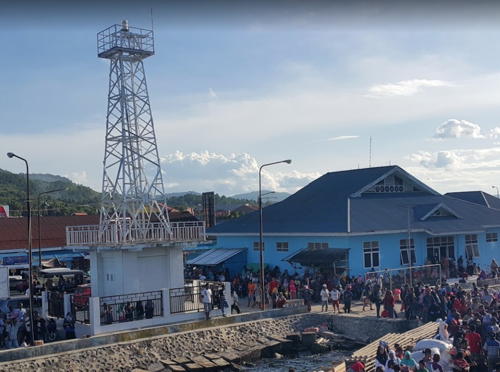
Salakan Light, Salakan, December 2017
Google Maps photo by Eko Wahyudiantoro
Tanjung Sambiut
Date unknown. Active; focal plane 14 m (46 ft); white flash every 4 s. 14 m (46 ft) white tower mounted on a platform supported by piles. No photo available but Bing has a satellite view. Located in the surf a short distance north of Abason village on the southeast coast of Pulau Pelang. Site open, tower closed. Admiralty Q1567.7; NGA 25275.8.
Banggai Laut Regency Lighthouses Pulau Toulon Besar
Date unknown. Active; focal plane 14 m (46 ft); red flash every 5 s. 14 m (46 ft) red barbell-shaped fiberglass tower mounted on a platform supported by piles. No photo available but Google has an indistinct satellite view. This light guides vessels in the Kahumbahgan Strait separating Pulau Peleng from Pulau Banggai. Located at the northern tip of Pulau Toulon Besar, a smaller island just off the west coast of Pulau Banggai. Site open, tower closed. Admiralty Q1567.8; NGA 25275.9. * Pulau Banggai (2)
Date unknown. Active; focal plane about 20 m (66 ft); white light, characteristic unknown. Approx. 17 m (56 ft) square white skeletal tower. Eko Wahyudiantoro has a street view and Google has an indistinct satellite view. NGA lists a very small tower with a continuous red light. Located on the quay at the town of Banggai, on the west coast of Pulau Banggai. Site open, tower closed. Admiralty Q1568; NGA 25276. Pulau Buangbuang (Buang Buang)
Date unknown. Active; focal plane 28 m (92 ft); white flash every 5 s. 25 m (82 ft) square skeletal tower, painted white. No photo available but Google has a satellite view of the station. Located on a small island at the southeastern tip of the Banggai group, marking a narrow passage between the Banggai reefs and those of the Sula group in North Maluku province. Accessible only by boat. Site status unknown. Admiralty Q1569; NGA 25380.
Morowali Utara (North Morowali) Regency Lighthouses Ambang Luar (Tomori Bay)
Date unknown. Active; focal plane 18 m (59 ft); white flash every 5 s. Described as a beacon with red and white horizontal bands. No photo available and the light does not appear in Google's satellite view. This light marks the entrance to the Tomori Bay, a complex embayment at the base of Sulawesi's eastern peninsula. Located about 16 km (10 mi) offshore. Accessible only by boat. Site open, tower closed. Admiralty Q1563; NGA 25264.
Tanjung Matube
Date unknown. Active; focal plane 16 m (52 ft); green flash every 4 s. 16 m (52 ft) "beacon," probably a green skeletal or fiberglass tower mounted on a platform supported by piles. No photo available and the light is not seen in Google's satellite view of the area. Oddly, NGA lists the light as "Tanjung Mposo." Located on the north side of the entrance to Tomori Bay. Site status unknown. Admiralty Q1564; NGA 25272. Tanjung Bea
Date unknown. Active; focal plane 18 m (59 ft); white flash every 5 s. 15 m (49 ft) skeletal tower, painted white. No photo available but Bing has a satellite view. Located on a promontory near the base of Sulawesi's eastern peninsula, near Morowali. Site status unknown. Admiralty Q1563.5; NGA 25268. Karang Dalam Oll
Date unknown. Active; focal plane 15 m (49 ft); white flash every 4 s. 15 m (49 ft) square white skeletal tower mounted on a platform supported by piles. No photo available but Google has a fuzzy satellite view. Located on a reef in the center of the entrance to the Tomori Bay. Accessible only by boat. Site open, tower closed. Admiralty Q1564.2; NGA 25273. Kolonodale
Date unknown. Active; focal plane 33 m (108 ft); two white flashes every 8 s. 30 m (98 ft) square skeletal tower, painted white. Sukri Ukhy's photo is at right and Google has a satellite view. Located at the harbor of Kolonodale, the regency capital and a seaport on the west coast of Tomori Bay. Site open, tower closed. Admiralty Q1564.7; NGA 25274. 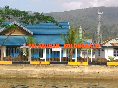
Kolonodale Light, Kolonodale, October 2015
Google Plus photo by Sukri Ukhi
Teluk Tomori South
Date unknown. Active; focal plane 14 m (46 ft); red light, 1.5 s on, 2.5 s off. 14 m (46 ft) red barbell-shaped fiberglass tower mounted on a platform supported by piles. No photo available but Bing has a satellite view. This light guides away from shoals at the southern entrance to Tomori Bay. Located at the nortnhern tip of Pulau Toulon Besar, a smaller island just off the west coast of Pulau Banggai. Site open, tower closed. Admiralty Q1563.2; NGA 25266.
Morowali Regency Lighthouses Note: The Morowali Regency includes the Menui Islands, a ragged chain extending east southeast into the Banda Sea. Karang Bungku
Date unknown. Active; focal plane about 15 m (49 ft); light characteristic unknown. Approx. 15 m (49 ft) square white skeletal tower mounted on a platform supported by piles. Muhammad Ilham has a distant view and Google has a fuzzy satellite view. Located on a reef that provides some partial shelter to the port of Bungku, the regency capital. Accessible only by boat. Site open, tower closed. Admiralty Q1562.9. Tanjung Losoni
Date unknown. Active; focal plane 50 m (164 ft); four white flashes every 10 s. Approx. 40 m (131 ft) white skeletal tower, probably with lanern and gallery. No photo available but Google has a satellite view of the station. This light stands on a promontory at Losoni on the central east coast of Sulawesi. Site status unknown. ARLHS IDO-311; Admiralty Q1562.93; NGA 25274.6. Karang Samaringa
Date unknown. Active; focal plane 13 m (43 ft); red flash every 5 s. 13 m (43 ft) square skeletal mast with gallery painted red and mounted on a square platform supported by piles. No photo available, but Google has a satellite view. Located on a reef northwest of Pulau Samaringa, a small island at the western end of the Menui Islands. Accessible only by boat. Site open, tower closed. Admiralty Q1559.95; NGA 25278. Pulau Menui (Manui)
Date unknown. Active; focal plane 45 m (148 ft); white flash every 4 s. Approx. 40 m (131 ft) square white skeletal tower. No photo available, but Bing has a satellite view. This major lighthouse marks the eastern end of the Manui Islands. Located on heights above the southeastern point of Pulau Manui, a 12 km (7.5 mi) long high island about 80 km (50 mi) northeast of Kendari. Accessible only by boat. Site status unknown. Admiralty Q1559.8; NGA 25279.
Information available on lost lighthouses:
Notable faux lighthouses:
Lighthouses of Indonesia: South Sulawesi (Celebes)
Indonesia has been independent since 1945 after having been the Dutch East Indies for more than 350 years. It is a huge country, stretching along both sides of the Equator for more than 46 degrees of longitude (roughly 5100 km or 3200 miles). Comprised of some 17,000 islands (more than 6000 inhabited islands), it has hundreds of major aids to navigation. This is one of five pages for lighthouses of Sulawesi (Celebes), a major island in the northern part of the country.
Shaped like an artistically drawn letter K, Sulawesi consists mostly of four narrow peninsulas. The Strait of Makassar separates Sulawesi from Kalimantan (Borneo) to the west. The Celebes Sea is north of the island, the Banda Sea is to the east and southeast, and the Flores Sea is on the south. Makassar, also called Ujung Pandang, is the major port. This page covers South Sulawesi Province, which includes the well-populated southern peninsula and a large number of islands in the Flores Sea, Java Sea, and Strait of Makassar.
The Indonesian word for a lighthouse is mercusuar. The phrase menara suar, which includes the Arabic word menara, is often used instead. Pulau is an island, tanjung or ujung ("end") is a cape or headland, karang is a reef, teluk is a bay, and pelabuhan is a port.
Aids to navigation in Indonesia are operated and maintained by the Directorate General of Sea Navigation.
ARLHS numbers are from the ARLHS World List of Lights. Admiralty numbers are from volumes F and Q of the Admiralty List of Lights & Fog Signals. U.S. NGA List numbers are from Publication 112. General Sources Online List of Lights - Indonesia - Vol. Q
Photos by various photographers posted by Alexander Trabas; photos for this area are by Jim Smith. Indonesian Lighthouses
Historic postcard views from the collection of Michel Forand. World of Lighthouses - Indonesia
Photos by various photographers available from Lightphotos.net. 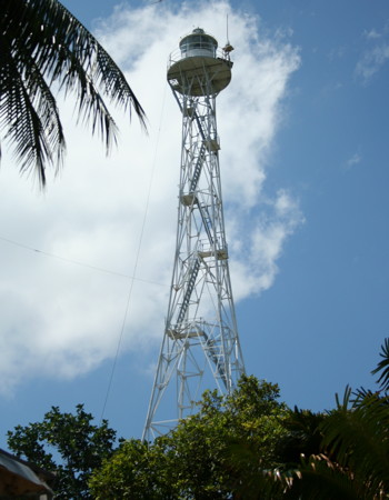
Pulau Kalu Kalukuang Light, Makassar Strait, May 2009
ex-Panoramio photo copyright Taufik Hidayatullah; used by permission
Gulf of Boni Lighthouses Note: The Gulf of Boni is a broad arm of the Flores Sea separating the southern and southeastern peninsulas of Sulawesi. The north and west shores of the Gulf are in South Sulawesi Province. Lighthouses of the east coast of the Gulf are described on the Southeast Sulawesi page.
Luwu Timur (East Luwu) Regency Lighthouses Pulau Bulu Bulu (Bulu Pulu, Bulupolo)
Date unknown. Active; focal plane 18 m (59 ft); white flash every 3 s. Approx. 15 m (49 ft) "white beacon." No photo available; Bing's satellite view suggests a white fiberglass or concrete tower. Located at the east end of Pulau Bulu Bulu, a forested island projecting into the northeastern embayment of the Gulf of Boni. Accessible only by boat. Site status unknown. Admiralty Q1545.6; NGA 25400. Pulau Mori (2?)
Date unknown. Active; focal plane 10 m (33 ft); white flash every 5 s. 7 m (23 ft) round barbell-shaped white fiberglass tower. No photo available but Google has a satellite view. NGA lists a white mast for this light. Located at the southern tip of a small island in the entrance to Teluk Usu, a bay at the northeastern corner of the Gulf of Boni. Accessible only by boat. Site status unknown. Admiralty Q1545; NGA 25404.
Palopo City Lighthouse * Palopo (Tanjung Ringgit)
Date unknown. Active; focal plane 14 m (46 ft); white flash every 3 s. 8 m (26 ft) square skeletal tower, painted white and mounted on a square concrete base. Ishak Bocha has a 2017 photo and Google has a street view and an indistinct satellite view. Located at the end of the main quay at Palopo, a city of 150,000 residents at the northwestern corner of the Gulf of Boni. Site open, tower closed. Admiralty Q1544; NGA 25390.
Luwu Regency Lighthouse Tanjung Jene
Date unknown. Active; focal plane 15 m (49 ft) (?); white flash every 5 s. 20 m (66 ft) square white skeletal tower mounted on a platform supported by piles. No photo available but Bing has a distant satellite view. Located off a swampy point of land about 30 km (19 mi) southeast of Palopo. Accessible only by boat. Site open, tower closed. Admiralty Q1542; NGA 25388.
Bone Regency Lighthouses Tanjung Lameriki
Date unknown. Active; focal plane 34 m (112 ft); white flash every 10 s. 30 m (98 ft) octagonal skeletal tower with lantern and gallery, painted white. No photo available but Google has a satellite view. Located on a low point of land on the central west coast of the Gulf of Boni, about 45 km (28 mi) north of Macoppe. Site status unknown. ARLHS IDO-306; Admiralty Q1541.3; NGA 25473.
* Bajoe (Bajowe)
Date unknown. Active; focal plane 8 m (26 ft); red flash every 4 s. 8 m (26 ft) square skeletal tower mounted on a square platform supported by piles. Google has a street view and an indistinct satellite view. Bajoe is the port for Watampone, a city of 80,000 residents that is the capital of Bone Regency. Located at the ferry terminal at the end of the long pier of Bajoe. Site open, tower closed. Admiralty Q1540.9; NGA 25470.5. Karang Limpogeh
Date unknown. Active; focal plane 15 m (49 ft); white flash every 3 s. 15 m (49 ft) square white skeletal tower mounted on a square platform supported by piles. No photo available but Bing has a distant satellite view. This light guides ships around a very large area of shoals and reefs in the southwestern Gulf of Boni. Accessible only by boat. Site open, tower closed. Admiralty Q1540; NGA 25470.
Kepulauan Selayar (Selayer Islands) Regency Lighthouses Note: The Selayer Islands extend south and then southeast into the Flores Sea from the southeastern tip of Sulawesi's Southern Peninsula. Pulau Selayer, a long island extending north and south, is the largest and northernmost of the islands.
Pulau Selayer Lighthouses Pulau Pasitanete (Menara Indah) (3)
Date unknown (station established 1898). Active; focal plane 65 m (213 ft); four white flashes every 20 s. 20 m (66 ft) square skeletal tower with lantern and gallery. Lighthouse painted white, lantern red. Several coast guard buildings. A photo is at right and Google has a satellite view of the station. The original lighthouse had a focal plane height of only 45 m (148 ft), so it must have been built at a lower location. The lighthouse marks the narrow Selayer Strait separating the Selayer Islands from Tanjung Bira, the southern tip of Suluwesi. Located on a small island off the northern end of the much larger island of Selayar, about 30 km (19 mi) southeast of Bulukumba. Accessible only by boat. Site status unknown. ARLHS IDO-234; Admiralty Q1536; NGA 25408. 
Pulau Pasitanete Light, Selayer, May 2007
ex-Panoramio photo copyright MACTAK MC; used by permission
* Pamatata
Date unknown. Active; focal plane about 30 m (98 ft); light characteristic unknown. Approx. 15 m (49 ft) square skeletal tower with gallery, painted white. Taufik Hidayatullah's photo is at right, and Google has a satellite view. Located at the ferry terminal at Pamatata, on the northeast coast of Pulau Selayer. Site open, tower closed. * Benteng
Date unknown. Active; focal plane about 15 m (49 ft); white light, characteristic unknown. Approx. 12 m (39 ft) square skeletal tower, painted white and mounted on a square 1-story equipment shelter. Swas Harimurti has a photo and Google has an indistinct satellite view. Located on the waterfront at Benteng, the regency capital and ferry port on the central west coast of Pulau Selayer. Site open, tower closed. Admiralty Q1538. Pulau Belangbelang
Date unknown. Active; focal plane 16 m (52 ft); white flash every 5 s. 10 m (33 ft) round barbell-shaped white fiberglass tower. No photo available but Bing has a distant satellite view. This light warns ships away from a large area of reefs and shoals east of Pulau Selayer. Located on a small island about 80 km (50 mi) east of Pulau Selayer. Accessible only by boat. Site status unknown. Admiralty Q1327.2; NGA 25662.2.
Pulau Jampea Lighthouses * Pelabuhan Tanah Jampea
Date unknown. Active; focal plane about 17 m (56 ft); white light, pattern unknown. Approx. 15 m (49 ft) square white skeletal tower with gallery mounted on a concrete base supported by piles. A distant view is available (3/4 the way down the page) and Bing has a satellite view. Located at the ferry terminal at the west end of Pulau Jampea, a large island about 65 km (40 mi) south of Pulau Selayer. Site open, tower closed. Admiralty Q1327.55. 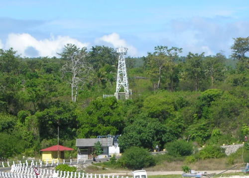
Pamatata Light, Selayer
ex-Panoramio photo copyright Taufik Hidayatullah; used by permission
Ujung Perumang (Tanjung Ringgi, Pulau Jampea)
Date unknown. Active; focal plane 11 m (36 ft); white flash every 5 s. Approx. 10 m (33 ft) "white beacon." No photo available; Google's distant satellite view suggests a white fiberglass tower. Located at the southeastern tip of Pulau Jampea. Site status unknown. Admiralty Q1327.5; NGA 25662.5.
Pulau Bonerate Lighthouses Pulau Bonerate
Date unknown. Active; focal plane 64 m (210 ft); three white flashes every 10 s. 30 m (98 ft) square skeletal tower, painted white. Several coast guard station buildings. No photo available but Bing has a satellite view of the station. Located on the southwest side of Pulau Bonerate, an island in the Flores Sea near the southeastern end of the Selayer group. Site status unknown. Admiralty Q1328; NGA 25663. Bonerate
Date unknown. Active; focal plane about 15 m (49 ft); red light, characteristic unknown. Approx. 12 m (39 ft) square skeletal tower, painted red and mounted on a platform support by piles. Ardi Suhardi has a photo, but the tower is not seen in Bing's satellite view. Located off the pier at Bonerate harbor, on the west side of the island. Not listed by the Admiralty. * Bonerate Harbor
Date unknown. Active; focal plane about 16 m (52 ft); white light, characteristic unknown. Approx. 12 m (39 ft) square skeletal tower, painted white and mounted on a platform support by piles. Sandas Block has a distant view (the tower is seen just to the right of the yellow waterfront building), and Google has an indistinct satellite view. Located on the waterfront at Bonerate harbor. Not listed by the Admiralty.
Southeastern Islands Lighthouses * Pulau Raja
Date unknown. Active; focal plane 12 m (39 ft); white flash every 2 s. 12 m (39 ft) round barbell-shaped white fiberglass tower mounted on a concrete platform supported by piles. A 2018 photo is available and Google has a satellite view.Located on the beach near the south end of Pulau Raja, a small inhabited island about 25 km (15 mi) north of Pulau Bonarate. Site open, tower closed. Admiralty Q1327.7; NGA 25664.
Pulau Kakabia
Date unknown. Active; focal plane 11 m (36 ft); white flash every 2 s. 10 m (33 ft) round white fiberglass tower. No photo available, but Google has a distant satellite view. Located near the south end of Pulau Kakabia, an uninhabited island at the extreme southeastern end of the Selayer group. Accessible only by boat. Site status unknown. Admiralty Q1328.5 NGA 25666.
Southern Peninsula and Makassar Area Lighthouses Bulukumba Regency Lighthouses Note: Bulukumba is a city of about 80,000 residents at the end of Sulawesi's southern peninsula. * Bira Port (Lasa)
Date unknown. Active; focal plane about 15 m (49 ft); red light, characteristic unknown. Approx. 12 m (39 ft) square skeletal tower, painted red and mounted on a platform support by piles. Google has a street view and an indistinct satellite view. Located just off the end of the south breakwater at Bira, a ferry port at the southeastern tip of Sulawesi's southern peninsula, opposite Pulau Selayer. Accessible only by boat but easily seen from nearby. Site open, tower closed. Admiralty Q1534. * Bulukumba (Kalumeme)
Date unknown. Active; focal plane 13 m (43 ft); white flash every 5 s. 10 m (30 ft) round barbell-shaped white fiberglass tower. Heru Purwanto's closeup photo is at right and Google has a street view and a satellite view. Located adjacent to the ferry terminal in Bulukumba. Site open, tower closed. Admiralty Q1532.5; NGA 25411. Tanjung Papanambeja (Bulukumba) (2)
Date unknown (station established 1904). Active; focal plane 26 m (85 ft); four white flashes every 20 s. 24 m (79 ft) sqaure skeletal tower with lantern and gallery, painted white. Google has a street view and a satellite view. The original tower had a height of 13 m (43 ft). Located on a promontory on the southwest side of Bulukumba. Site status unknown. ARLHS IDO-121; Admiralty Q1532; NGA 25412. 
Bulukumba Light, Bulukumba, September 2006
Google Plus photo by Heru Purwanto
Bantaeng Regency Lighthouse
* Bantaeng
Date unknown. Active; focal plane about 13 m (43 ft); light characteristic unknown. Approx. 12 m (39 ft) square skeletal tower with gallery, painted white, mounted on a square concrete base supported by piles. Asrul Noer's photo is at right, and Google has a street view and a satellite view. Located at the base of a long pier at Bantaeng. Site open, tower closed. Not listed by the Admiralty.
Jeneponto Regency Lighthouses Teluk Jeneponto
Date unknown. Active; focal plane about 15 m (49 ft); light characteristic unknown. Approx. 15 m (49 ft) round barbell-shaped white fiberglass tower mounted on a concrete platform supported by piles. No photo available but Google has a satellite view. Located on the east side of the entrance to the bay of Jeneponto. Accessible only by boat. Site open, tower closed. Admiralty Q1531. * Jeneponto (Jene Ponto)
Date unknown. Active; focal plane about 13 m (43 ft); light characteristic unknown. Approx. 12 m (39 ft) square skeletal tower with gallery, painted white, mounted on a square concrete base supported by piles. Aswin Bahar has a photo and Google has a street view and an indistinct satellite view. Located near the base of a long pier at Jeneponto. Site open, tower closed. Admiralty Q1530. * Tanjung Bulu Bulu
Date unknown. Active; focal plane 42 m (138 ft); white flash every 10 s. Approx. 40 m (131 ft) square skeletal tower with lantern and gallery, painted white. Several coast guard station buildings. No photo available but Google has a satellite view of the station. Located at the southern tip of the Southern Peninsula near Binamu. Accessible by road. Site probably open, tower closed. Admiralty Q1528; NGA 25414. 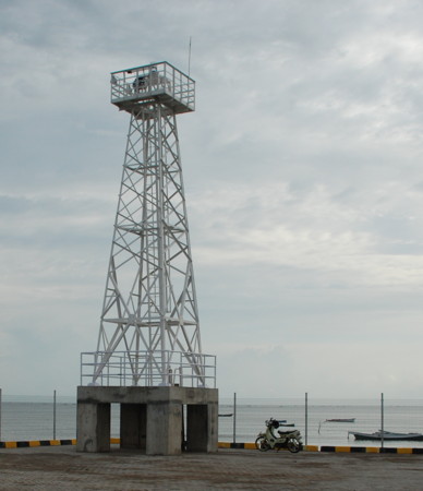
Bantaeng Light, Bantaeng, February 2009
Panoramio photo copyright Asrul Noel; permission requested
Takalar Regency Lighthouses Pulau Tanakeke
Date unknown. Active; focal plane 24 m (79 ft); white flash every 10 s. 20 m (66 ft) octagonal white concrete tower with lantern and gallery. No photo available but Bing has a satellite view. Pulau Tanakeke is a populated island about 15 km (9 mi) southwest of Patalasang, on the southwestern tip of Sulawesi. Located at the southern tip of the island. ARLHS IDO-250; Admiralty Q1518.5; NGA 25421.
Pulau Tanakeke East
Date unknown. Active; focal plane about 16 m (52 ft); light characteristic unknown. Approx. 16 m (52 ft) square white skeletal tower mounted on a platform supported by piles. No photo available but Google has a satellite view. Located off the east coast of Pulau Tanakeke. Accessible only by boat. Site open, tower closed. Admiralty Q1519; NGA 25422. Pulau Dayangdayangan (2)
Date unknown (station established 1893). Active; focal plane 42 m (138 ft); white flash every 5 s. 30 m (98 ft) square skeletal tower with gallery, painted white. Several coast guard station buildings. No photo available but Bing has a satellite view. The original lighthouse had a focal plane height of 32 m (105 ft). Located on a small island about 10 km (6 mi) northwest of Pulau Tanakeke. Accessible only by boat. Site status unknown. ARLHS IDO-196; Admiralty Q1518; NGA 25424. Pulau Sangrabengi
Date unknown. Active; focal plane about 16 m (52 ft); light characteristic unknown. Approx. 16 m (52 ft) square white skeletal tower mounted on a platform supported by piles. No photo available but Bing has a satellite view. Located west of Pulau Sangrabengi, a small island off the town of Galesong. Accessible only by boat. Site open, tower closed. Admiralty Q1518.3.
Makassar City Lighthouses Note: Makassar is the capital of South Sulawesi, by far the largest city of the island, and the fifth largest city of Indonesia; the metropolitan area has a population of about 2 million. Kodingareng (Kudingareng) Lompo
Date unknown. Active; focal plane 41 m (135 ft); four white flashes every 27 s. 40 m (131 ft) square skeletal tower with lantern and gallery, painted white; lantern painted red. Trabas has Smith's photo (also seen at right), Arham Muhammad has a 2012 photo (first photo on the page), a small photo is available (3/4 the way down the page), and Google has an indistinct satellite view. Located at the south end of a small but densely populated island about 15 km (9 mi) west of Makassar. Accessible only by boat. Site status unknown. ARLHS IDO-023; Admiralty Q1517; NGA 25432. 
Kodingareng Lompo Light, Makassar, January 2019
photo copyright Jim Smith; used by permission
Pulau Samalona
Date unknown. Active; focal plane 15 m (49 ft); two green flashes every 5 s. 15 m (49 ft) square skeletal tower, painted white and mounted on a square platform supported by piles. Trabas has Smith's photo, another of his photos is at right and Google has an indistinct satellite view. Located at the north end of the reef surrounding Pulau Samalona, an islet about 8 km (5 mi) west of the Makassar waterfront. Accessible only by boat. Site open, tower closed. Admiralty Q1511; NGA 25436. Makassar Entrance South Side (2)
2018. Active; focal plane 15 m (49 ft); green flash every 3 s. 15 m (49 ft) square skeletal tower with gallery painted green. Trabas has Smith's photo and Google has a satellite view. This light replaced a round barbell-shaped tower, which was still present when Jim Smith visited in January 2019 but probably will be removed. The entrance to the harbor of Makassar is through a narrow opening in a fringing reef that protects the port from storms. Located on the south side of this entrance. Accessible only by boat. Site open, tower closed. Admiralty Q1514; NGA 25448. Makassar Entrance North Side (2)
2018. Active; focal plane 15 m (49 ft); red flash every 4 s. 15 m (49 ft) square skeletal tower with gallery painted red. Trabas has Smith's photo and Google has a satellite view. This light replaced a round barbell-shaped tower, which was still present when Jim Smith visited in January 2019 but probably will be removed. Located on the north side of the harbor entrance. Accessible only by boat. Site open, tower closed. Admiralty Q1513; NGA 25444. * Makassar Quay
Date unknown. Active; focal plane 32 m (105 ft); white flash every 3 s. Triangular skeletal tower, painted red with a white horizontal band, mounted atop a waterfront building. Trabas has Smith's photo, Aswn Bahar has a 2016 photo and Google has a satellite view. Located at the south end of the main quay of Makassar harbor. Site open, tower closed. Admiralty Q1515; NGA 25452. 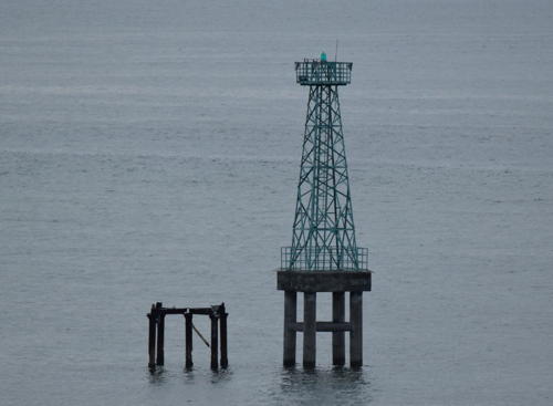
Pulau Samalona Light, Makassar, January 2019
contributed photo by Jim Smith; used by permission
Agampencara (3?)
Date unknown. Active; focal plane about 22 m (72 ft); green flash every 5 s. Approx. 20 m (66 ft) square skeletal tower with gallery, painted green, mounted on a square concrete base supported by piles. Trabas has Smith's photo, another of his photos is at right, Rudi Hamdani has a street view and Google has a satellite view. NGA calls this the Paotere light and lists its height as 8 m (26 ft). The current light replaced a skeletal tower about 14 m (46 ft) high. Located at the end of the west breakwater of the Paotere fishing harbor on the north side of Makassar. Accessible by walking the pier. Site open, tower closed. Admiralty Q1510.5; NGA 25458. Paotere (2?)
Date unknown. Active; focal plane about 20 m (66 ft); red flash every 5 s. Approx. 14 m (46 ft) square skeletal tower with gallery, painted red, mounted on a square concrete base supported by piles. Trabas has Smith's photo and Google has a satellite view. Located just off the end of the east breakwater of the Paotere fishing harbor. Accessible only by boat. Site open, tower closed. Admiralty Q1510.43.
Pangkajene Dan Kepulauan Regency: Mainland Lighthouses * Maccini Baji
Date unknown. Active; focal plane about 16 m (52 ft); light characteristic unknown. Approx. 14 m (46 ft) square white skeletal tower. Fer Raintung has a photo but the tower is inconspicuous in Google's satellite view. Located on the pier at Maccini Baji, a small port about 35 km (22 mi) north of Makassar. Site open, tower closed. 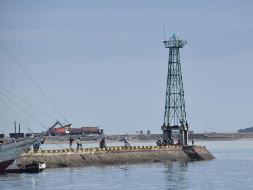
Agampencara Light, Makassar, January 2019
contributed photo by Jim Smith; used by permission
Barru Regency Lighthouse Gorongkong
Date unknown. Active; focal plane 24 m (79 ft); white flash every 5 s. 20 m (66 ft) square white skeletal tower with gallery mounted on a concrete platform supported by piles. Muhammad Gaus has a 2018 photo and Google has a satellite view. Gorongkong is the site of a large cement plant. Located beside the pier at Gorongkong. Site status unknown. Admiralty Q1506.7.
Parepare City Lighthouse Tanjung Lero
Date unknown. Active; focal plane 14 m (46 ft); red flash every 5 s. 14 m (46 ft) square white skeletal tower with gallery mounted on a concrete platform supported by piles. No photo but Google has a satellite view. Parepare is a seaport with about 130,000 residents about 155 km (96 mi) north of Makassar. Located on a reef about 250 m (0.15 mi) off the north side of the entrance to Parepare Bay. Accessible only by boat. Site open, tower closed. Admiralty Q1506; NGA 25476.
Pangkajene Dan Kepulauan (Pangkajene and Islands) Regency: Island Lighthouses Spermonde (Sangkarang) Islands Lighthouses Note: The Spermonde Islands include some 120 islands and sandy reefs in the Strait of Makassar northwest of Makassar City. Pulau Lanyukang (Lanjukang)
Date unknown. Active; focal plane 24 m (79 ft); white flash every 10 s. 20 m (66 ft) round white concrete tower with 8 ribs, lantern and gallery. A photo (a little over halfway down the page) is available and Bing has a satellite view. Located on an islet about 40 km (25 mi) northwest of Makassar (the outermost of a large group of small islands). Accessible only by boat. Site status unknown. Admiralty Q1508.5; NGA 25461. Bone Penambungan
Date unknown. Active; focal plane 15 m (49 ft); green flash every 4 s. 15 m (49 ft) square skeletal tower, painted white and mounted on a platform supported by piles. No photo available but Google has a satellite view. Located on a shoal about 20 km (13 mi) north of Makassar. Accessible only by boat. Site open, tower closed. Admiralty Q1510; NGA 25460.
Batu Bayangan
Date unknown. Active; focal plane 15 m (49 ft); red flash every 3 s. 15 m (49 ft) square skeletal tower, painted white and mounted on a platform supported by piles. No photo available but Bing has a satellite view. Located on a shoal about 10 km (6 mi) north of the Bone Penambungan light. Accessible only by boat. Site open, tower closed. Admiralty Q1509.5; NGA 25464. Pulau Kapoposang (1)
1906. Inactive since 1957. Approx. 25 m (82 ft) cast iron tower with lantern and gallery, painted white. Andika Ferial's view from the sea at right shows this historic Dutch lighthouse and its modern replacement. This important light station marks the westernmost of the Spermonde Islands and reefs in the southeastern quadrant of the Makassar Strait. Site open, tower closed. Pulau Kapoposang (2)
1957 (station established 1906). Active; focal plane 36 m (118 ft); white flash every 5 s. 33 m (108 ft) skeletal tower with lantern and gallery, painted red (?). Several coast guard station buildings. Andika Ferial's view from the sea is at right, S. Budiarto has a very distant photo, and Bing has an indistinct satellite view of the station. Kapoposang is a popular destination for scuba divers. Located at the west point of an island in the Makassar Strait, about 100 km (60 mi) northwest of Makassar in southwestern Sulawesi. Accessible only by boat. Site open, tower closed. ARLHS IDO-022; Admiralty Q1508; NGA 25468. 
Kapoposang Lights, Makassar Strait, May 2008
Panoramio photo copyright Andika Ferial; permission requested
Northern Flores Sea Lighthouses Note: These lighthouses are on reefs partially obstructing the southern entrance to the Strait of Makassar. Pulau Kalu Kalukuang
Date unknown. Active; focal plane 44 m (144 ft); four white flashes every 30 s. 40 m (131 ft) square tapered skeletal tower with lantern and gallery, painted white. Taufik Hidayatullah's closeup photo is at the top of this page, he also has a view from the sea, and Google has a satellite view. Located at the north end of a small but inhabited island in the middle of the south entrance to the Makassar Strait, about 180 km (110 mi) west of Makassar. Accessible only by boat. Site status unknown. ARLHS IDO-139; Admiralty Q1442.7; NGA 24982.
Karang Takabakang
Date unknown. Active; focal plane 15 m (49 ft); white flash every 5 s. 15 m (49 ft) square skeletal tower, painted white and mounted on a platform supported by piles. No photo available but Bing has a satellite view. Located on a shoal about 10 km (6 mi) north of the Bone Penambungan light. Accessible only by boat. Site open, tower closed. Admiralty Q1509; NGA 25425. Pulau Dewakang Besar
Date unknown. Active; focal plane 33 m (108 ft); white flash every 5 s. 30 m (98 ft) white iron skeletal tower. Several coast guard station buildings. No photo available but Google has a satellite view of the station. Located on the north end of a small island about 105 km (65 mi) west southwest of Makassar. Accessible only by boat. Site status unknown. ARLHS IDO-125; Admiralty Q1522; NGA 25420. Pulau Bangkauluang
Date unknown. Active; focal plane 15 m (49 ft); white flash every 5 s. 14 m (46 ft) square skeletal tower painted white. No photo available and Google has only a fuzzy satellite view of the location. Located near the south end of an uninhabited island about 20 km (13 mi) east of Dewakang Besar. Accessible only by boat. Site status unknown. Admiralty Q1523; NGA 25423. Karang Takarewataya (De Bril, Den Bril)
1887. Active; focal plane 25 m (82 ft); white flash every 10 s. 23 m (75 ft) octagonal cast iron tower with lantern and three galleries, painted with red and white horizontal stripes. Damien Loong's photo is at right, Lightphotos.net has a historic closeup photo, the Amsterdam Tropenmuseum has a 1929 distant view, and a fuzzy spot marks the lighthouse in Google's fuzzy satellite view of the reef. This is the only survivor among several lighthouses of this class built in the Dutch Indies. Located at the south end of a reef in the Flores Sea about 120 km (75 mi) south southwest of the southern point of Sulawesi. Accessible only by boat; fishing tours to the reef are available. Site status unknown. ARLHS IDO-009; Admiralty Q1524; NGA 25416. 
Karang Takarewataya Light, Java Sea, November 2008
photo copyright Damien Loong; permission requested
Sabalana Islands Lighthouses Note: The Sabalana islands comprise an atoll in the Flores Sea far to the southwest of Sulawesi. They are administered as part of the Pangkajene Dan Kepulauan (Pangkajene and Islands) Regency. Pulau Banawaja (Banawawa) (2)
Date unknown (station established 1913). Active; focal plane 32 m (105 ft); two white lights every 5 s. Approx. 27 m (89 ft) "white beacon." No photo available but Google has an indistinct satellite view. The original lighthouse had a focal plane height of 20 m (66 ft). Located on a small island on the east side of the Sabalana atoll, in the middle of the Flores Sea about 150 km (90 mi) south of the southern point of Sulawesi. Accessible only by boat. Site status unknown. Admiralty Q1325; NGA 25416.5. Pulau Jailamu (2?)
Date unknown. Active; focal plane 17 m (56 ft); white flash every 5 s. NGA describes this as a 10 m (33 ft) fiberglass tower, but two very distant views (no longer online) suggest a taller, possibly skeletal tower. No photo available but Google has a satellite view. Located on a small island at the north end of the Sabalana Islands about 210 km (130 mi) south southwest of Makassar and 65 km (40 mi) northwest of Banawaja. Accessible only by boat. Site status unknown. Admiralty Q1325.3; NGA 25416.6.
Pulau Longkoitang
Date unknown. Active; focal plane 32 m (105 ft); white flash every 5 s. Approx. 30 m (98 ft) square skeletal tower with gallery, painted white. No photo available but Bing has a satellite view. Located on a small inhabited island on the northwest side of the Sabalana atoll about 80 km (50 mi) west southwest of Pulau Jailamu. Accessible only by boat. Site status unknown. Admiralty Q1325.5; NGA 25416.7. Pulau Sarege
Date unknown. Active; focal plane about 16 m (52 ft); lightcharacteristic unknown. Approx. 16 m (52 ft) square skeletal tower mounted on a platform supported by piles. No photo available but Bing has a satellite view. Located off the southern tip of Pulau Serege, a small island on the southt side of the Sabalana atoll. Accessible only by boat. Site status unknown. Admiralty Q1324.5; NGA 25586.
Tengah Islands Lighthouses Note: The Tengah islands are scattered to the southwest of the Sabalana Islands; they are quite far away from Sulawesi and rather close to Sumbawa in the Lesser Sunda Islands. They are administered as part of the Pangkajene Dan Kepulauan (Pangkajene and Islands) Regency. Pulau Kapoposangbali (Kapoposang Bali)
1996. Active (?); focal plane 34 m (112 ft); white flash every 10 s. 30 m (98 ft) white concrete tower with lantern and gallery. A photo is at right and Google has a satellite view. In November 2016 residents were complaining that the lighthouse had been out of service for at least a year. Located on a small island of the Tengah group, far across the Java Sea, roughly 360 km (225 mi) southwest of Makassar and only 80 km (50 mi) off the north coast of Lombok in the Lesser Sunda Islands. Accessible only by boat. Site status unknown. ARLHS IDO-203; Admiralty Q1322; NGA 25578. 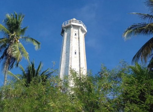
Kaposang Bali Light, Pulau Kaposang
photo by Munjiyah Dirga Gazali for tribunpangkep.com; permission requested
Gosong Sakunci
Date unknown. Active; focal plane 17 m (56 ft); white flash every 4 s. 15 m (49 ft) square skeletal tower with gallery, painted white. No photo available and the light is not seen in Bing's distant satellite view of the reef. This light marks the southwest end of the extensive reef system that extends from the Sabalana and Tengah Islands. Located on a reef about 65 km (40 mi) north of Utan, Sumbawa. Accessible only by boat. Admiralty Q1303; NGA 25580.
Information available on lost lighthouses:
Fort Rotterdam (1861-1930s), Makassar. The Netherlands Archives has a closeup historic photo, Wikimedia has four historic photos from the Amsterdam Tropenmuseum, and Klaus Huelse has a distant postcard view of the lost lighthouse. Sadly, nothing remains of this historic lighthouse. ARLHS IDO-365.
Notable faux lighthouses:
Lighthouses of Indonesia: Southeast Sulawesi (Celebes)
Indonesia has been independent since 1945, after having been the Dutch East Indies for more than 350 years. It is a huge country, stretching along both sides of the Equator for more than 46 degrees of longitude (roughly 5100 km or 3200 miles). Comprised of some 17,000 islands (more than 6000 inhabited islands), it has hundreds of major aids to navigation. The lighthouses on this page are on and around Sulawesi (Celebes), a major island in the northern part of the country.
Shaped like an artistically drawn letter K, Sulawesi consists mostly of four narrow peninsulas. The Makassar Strait separates Sulawesi from Kalimantan (Borneo) to the west. The Celebes Sea is north of the island, the Banda Sea is to the east and southeast, and the Flores Sea is on the south. Makassar, also called Ujung Pandang, is the major port. This page covers the lighthouses of Southeast Sulawesi (Sulawesi Tenggara) Province, which includes the blunt southeastern peninsula of the island and large number of islands offshore.
The Indonesian word for a lighthouse is mercusuar. The phrase menara suar, which includes the Arabic word menara, is sometimes used instead. Pulau is an island and karang is a reef.
Aids to navigation in Indonesia are operated and maintained by the Directorate General of Sea Navigation.
ARLHS numbers are from the ARLHS World List of Lights. Admiralty numbers are from volumes F and Q of the Admiralty List of Lights & Fog Signals. U.S. NGA List numbers are from Publication 112. General Sources Online List of Lights - Indonesia - Vol. Q
Coming soon: photos by various photographers posted by Alexander Trabas. Indonesian Lighthouses
Historic postcard views from the collection of Michel Forand. World of Lighthouses - Indonesia
Photos by various photographers available from Lightphotos.net. 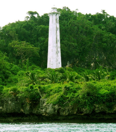
Tanjung Kanolanatumbi Light, Pulau Buton
photo copyright musafirtimur; used by permission
Konawe Utara (North Konawe) Regency Lighthouse
Pulau Dehaan (Pulau Labengki Kecil)
2007. Active; focal plane 55 m (180 ft); four white flashes every 10 s. Approx. 40 m (131 ft) white concrete tower. A view from the sea by Muhammed Idris is at right, and Bing has a satellite view. Located on a small island about 65 km (40 mi) north of Kendari. Accessible only by boat. Site status unknown. Admiralty Q1559.97; NGA 25278.5.
Konawe Regency Lighthouse Konawe
Date unknown. Active; focal plane 15 m (49 ft); white flash every 5 s. 10 m (33 ft) square skeletal tower with gallery, painted white. Google has a street view and an indistinct satellite view. Located at a small harbor about 15 km (9 mi) north of Kendari. Site open, tower closed. Admiralty Q1562.5.
Kendari City Lighthouses Note: Kendari is a port city on the east coast and the capital of Southeast Sulawesi province. It is the fourth largest city of Sulawesi, with a population of about 320,000. Teluk Kendari No. 1 (Range Front)
Date unknown. Active; focal plane 9 m (30 ft); white light, 2 s on, 2 s off. 10 m (33 ft) square skeletal tower with gallery, painted white. Jl. R. E. Martadinata has a street view and Google has a satellite view. Located off the ferry terminal at Kendari. Accessible only by boat, but easily seen from shore or from ferries. Site open, tower closed. Admiralty Q1560.3; NGA 25290. 
Pulau Dehaan (Labengki Kecil) Light, Banda Sea, May 2012
Panoramio photo copyright Muhammad Idris; permission requested
Teluk Kendari No. 2 (Range Rear)
Date unknown. Active; focal plane 11 m (36 ft); white light, 1 s on, 1 s off. 12 m (39 ft) square skeletal tower with gallery, painted white. Jl. R. E. Martadinata has a street view and Google has a satellite view. Located 130 m (430 ft) west of the front light. Accessible only by boat, but easily seen from shore or from ferries. Site open, tower closed. Admiralty Q1560.31; NGA 25290.2. Kendari
Date unknown. Active; focal plane 14 m (46 ft); white flash every 3 s. Approx. 12 m (39 ft) white tower. No photo available but Google has a satellite view. Located on the waterfront of Kendari. Site status unknown. Admiralty Q1562; NGA 25308.
Tanjung Kendari No. 3 (Range Front)
Date unknown. Active; focal plane 14 m (46 ft); white light, 1 s on, 1 s off. 15 m (49 ft) square skeletal tower with gallery, painted white. No photo available but Google has a street view and a satellite view. This is a downstream range guiding vessels leaving Kendari. Located on the south side of the Kendari estuary. Site open, tower closed. Admiralty Q1560.4. Tanjung Kendari No. 4 (Range Rear)
Date unknown. Active; focal plane 16 m (52 ft); white light, 1 s on, 1 s off. 16 m (52 ft) square skeletal tower with gallery, painted white. No photo available but Google has an indistinct satellite view and a street view through trees. Located a short distance southeast of the front light. Site open, tower closed. Admiralty Q1560.41. Tanjung Kendari No. 5 (Range Front)
Date unknown. Active; focal plane 15 m (49 ft); white light, 2 s on, 2 s off. 12 m (39 ft) square skeletal tower with gallery, painted white. Google has a street view and a satellite view. Located on the south side of the Kendari estuary. Site open, tower closed. Admiralty Q1560.5. Tanjung Kendari No. 6 (Range Rear)
Date unknown. Active; focal plane 16 m (52 ft); white light, 1 s on, 1 s off. 16 m (52 ft) square skeletal tower with gallery, painted white. Moch Said S. Sirate's photo is at right and Google has a street view and a satellite view. Located about 130 m (430 ft) southwest of the front light, adjacent to a bridge on the south side of the Kendari estuary. Site open, tower closed. Admiralty Q1560.51. 
Kendari No. 6 Light, Kendari, October 2013
Panoramio Creative Commons photo by Moch Said S. Sirate
Kabupaten Konawe (Konawe Islands) Regency Lighthouses Note: This regency is essentially coincident with Pulau Wawonii (also spelled Wowoni), a roughly heart-shaped island about 30 km (20 mi) in diameter located off to the southeast of Kendari. Pulau Wowoni (Tanjung Pamali)
Date unknown. Active; focal plane 44 m (144 ft); four white flashes every 20 s. Approx. 38 m (125 ft) square skeletal tower with lantern and gallery. Tower painted white. Coast guard station with staff quarters and other buildings. Mokry Tyov has a view from the sea, the lighthouse is visible in a very distant view from the sea and Bing has a satellite view. Located at the northern tip of the island. Accessible only by boat. Site status unknown. Admiralty Q1559.7; NGA 25288. Tanjung Watutembatu
Date unknown. Active; focal plane 65 m (213 ft); four white flashes every 10 s. 40 m (131 ft) skeletal tower, painted white. Mursal Fauzka has a very distant view (lighthouse near the left edge of the photo) and Google has a fuzzy satellite view. This light stands on a promontory at the easternmost tip of the island. Site status unknown. ARLHS IDO-334; Admiralty Q1559.9; NGA 25289.
Konawe Selatan (South Konawe) Regency: East Coast Lighthouse Campada South
Date unknown. Active; focal plane 17 m (56 ft); red flash every 4 s. 17 m (56 ft) square skeletal tower, painted red, mounted on a square platform supported by piles. No photo available, but Bing has an indistinct satellite view. Located at the south end of a reef on the west side of the strait separating Wowoni from the mainland. Accessible only by boat. Site open, tower closed. Admiralty Q1558.7; NGA 25310.
Buton Utara (North Buton) Regency Lighthouses Note: This regency occupies the northern half of Pulau Buton (formerly Butong), a large island located off the southeastern tip of Sulawesi. Pulau Buton is a substantial island about 120 km (75 mi) long; it is separated from Pulau Muna to the west by the Buton Strait, a narrow north-south channel. Tanjung Loba
Date unknown. Active; focal plane 32 m (108 ft); two white flashes every 8 s. Approx. 28 m (92 ft) square skeletal tower with gallery, painted white. Google has a distant street view and a satellite view. Located on a prominent point of land on the northwest coast of Pulau Buton. Site status unknown. Admiralty Q1550.5; NGA 25317.
Tanjung Buton
Date unknown. Active; focal plane 60 m (197 ft); white flash every 3 s. Described only as a "beacon." No photo available, but Google's satellite view reveals a white tower of unknown height. Located in a heavily forested area at the northern tip of Pulau Buton. Site status unknown. Admiralty Q1558.4; NGA 25311. * Lasora (Teluk Koro)
Date unknown. Active; focal plane about 20 m (66 ft); white light, flash interval unknown. Approx. 18 m (59 ft) square skeletal tower painted white. Difa Fitriani Sparkyu has a photo, Romi Wandaka has a photo, and Google has a satellite view. Koro Bay (Teluk Koro) is a well-protected but shallow bay on the central east coast of Buton. Located on the waterfront in Lasora. Site open, tower closed. Admiralty Q1558.372.
Buton Regency Lighthouses Tanjung Kanolanatumbi
Date unknown. Active; focal plane 45 m (148 ft); white flash every 10 s. 30 m (98 ft) white concrete tower with lantern and gallery. A photo is at the top of this page and Google has a satellite view. This light stands on the eastern point of Pulau Buton. Site status unknown. ARLHS IDO-302; Admiralty Q1555.8; NGA 25346. Tanjung Kordoa (Kondowa)
Date unknown. Active; focal plane 20 m (66 ft); white flash every 4 s. Approx. 12 m (39 ft) white concrete tower. No photo available but Bing has a satellite view. Located on a promontory on the southeast coast of Pulau Buton. Site status unknown. Admiralty Q1555; NGA 25344. Tanjung Batu Toro (Batutoro)
Date unknown. Active; focal plane 50 m (164 ft); white flash every 10 s. Approx. 35 m (115 ft) octagonal white concrete tower with lantern and gallery. A photo by Muhammad Aris is at right and Google has a good satellite view. This major lighthouse seems to be very poorly known. Located at the southeastern tip of Pulau Buton. Site open, tower closed. Admiralty Q1554.4; NGA 25342. Pulau Batuata (Batuatas, Batu Atas)
Date unknown. Active; focal plane 144 m (472 ft); two white flashes every 5 s. Described only as a white beacon. No photo available and the lighthouse has not been found in Google's satellite view. Located on an isolated (but inhabited) high island about 32 km (20 mi) south of the southern tip of Pulau Buton. Site status unknown. Admiralty Q1553.2; NGA 25352.5. 
Tanjung Batutoro Light, Pulau Buton, April 2017
ex-Google Plus photo by Muhammad Aris
Tanjung Masige (Tanjung Masiga, Pulau Siumpu)
Date unknown. Active; focal plane 20 m (66 ft); white flash every 5 s. 19 m (62 ft) square skeletal tower, painted white. No photo available but Bing has a satellite view. Located on a reef off the southwestern tip of Pulau Siumpu, an island off the southwestern tip of Butan. Site status unknown. ARLHS IDO-280; Admiralty Q1553; NGA 25352. * Pulau Kadatua (Tanjung Bauabungi)
Date unknown. Active; focal plane 15 m (49 ft); three white flashes every 10 s. 15 m (49 ft) square skeletal tower, painted white, mounted on a platform supported by four robust piles. Mardan Tambang has a photo and Google has a satellite view. Located just off the northern tip of Pulau Kadatua, an island about 10 km (6 mi) southwest of Bau-Bau. Site open, tower closed. Admiralty Q1552.6; NGA 25340.
Bau-Bau City Lighthouses Note: Located at the southwestern end of Pulau Buton, Bau-Bau is the principal city of the island; it has a population of about 140,000. * Bau-Bau
Date unknown. Active; focal plane 12 m (39 ft); white flash every 4 s. Approx. 11 m (36 ft) round barbell-shaped white fiberglass tower mounted on a square base. Bernard Tan has a photo, Zul Lenovo has a photo, and Google has an indistinct satellite view. Bau-Bau is the largest city of Pulau Buton with a population of about 140,000. Located on the side of a quay at Bau-Bau. Site open, tower closed. Admiralty Q1552; NGA 25332. Tanjung Batu Sori (Batusori)
Date unknown. Active; focal plane 25 m (82 ft); white flash every 3 s. Approx. 20 m (66 ft) tower. No photo available but Bing has a satellite view. Located on the west coast of Buton at the narrowest point of the Buton Strait. Site status unknown. Admiralty Q1551.8; NGA 25330.
Wakatobi Regency Lighthouses Note: This regency comprises the Wakatobi Islands, a chain of rather small islands extending southeast from Pulau Buton. The major islands are well inhabited with a total population of more than 90,000.
Pulau Wangiwangi
Date unknown (station established 1904). Active; focal plane 150 m (492 ft); two white flashes every 12 s. 21 m (69 ft) skeletal tower, painted white. Savitri Kusuma has the photo at right, a 2018 photo is available, Baizul Zaman has a closeup photo, Waode NaniKurnia has on Twitter a photo taken on the gallery of the lighthouse, and Google has a satellite view of the station. Pulau Wangiwangi is an island in the Wakatobi group, east of Buton. Located on the northern tip of the island, 35 km (22 mi) east of Tanjung Kanolanatumbi. Site open, tower closed. ARLHS IDO-259; Admiralty Q1558; NGA 25348. Pulau Tengah (Teluk Wanji, Kapota)
Date unknown. Active; focal plane 18 m (59 ft); white flash every 3 s. Approx. 16 m (52 ft) square skeletal tower painted white. Andreas Muljadi has a view from the sea and Google has a satellite view. NGA lists the light as "Midden." Located at the east end of Pulau Tengah ("Central Island") across from the waterfront of Wanji, a port on the west coast of Pulau Wangiwangi. Site status unknown. Admiralty Q1558.2; NGA 25348.5. Pulau Kaledupa
2017. Active; focal plane about 20 m (66 ft); light characteristic unknown. Approx. 20 m (66 ft) square skeletal tower mounted on a square concrete platform supported by piles. Irsyad Muhammad has a photo, but the lighthouse is too new to appear in Google's satellite view. A May 2017 aerial photo shows the platform but not the tower. Located at the northwestern tip of Pulau Kaledupa, about 13 km (8 mi) southeast of Pulau Wangiwangi. Site open, tower closed. Admiralty Q1558.27. 
Pulau Wangiwangi Light, Banda Sea, October 2011
ex-Panoramio photo copyright Savitri Kusuma; used by permission
Pulau Binongko (Tadunna)
Date unknown. Active; focal plane 45 m (148 ft); white flash every 10 s. Approx. 40 m (131 ft) octagonal white concrete tower with lantern and gallery. A travel site has a photo, the lighthouse appears in a YouTube video, and Google has a satellite view. Located at the southern tip of Pulau Binongko, the southernmost major island of the Wakatobi group. Site status unknown. Admiralty Q1558.34; NGA 25350.4. Pulau Moromaho
Date unknown. Active; focal plane 45 m (148 ft); four white flashes every 10 s. Approx. 40 m (131 ft) octagonal white concrete tower with lantern and gallery. No photo available, but Google has a satellite view of the station. Located on a small island at the extreme end of the Wakatobi Islands and at the junction of the Banda and Flores Seas. The island is a well known scuba diving site. Accessible only by boat. Site open, tower closed. ARLHS IDO-225; Admiralty Q1558.33; NGA 25351.
Muna Regency Lighthouses Note: Pulau Muna lies just to the west of Pulau Buton, separated from it by the narrow Buton Strait. The island is about 75 km (47 mi) long and as much as 40 km (25 mi) wide; it has a population of about 270,000.
* Tampo
Date unknown. Active; focal plane 12 m (39 ft); white flash every 3 s. 10 m (33 ft) square white skeletal tower. Fadjar Barakati's photo is at right and Google has a street view but the tower is hard to distinguish in Google's satellite view. Located near the foot of the pier at Tampo, on the northeastern end of Pulau Muna. Site open, tower closed. Admiralty Q1550; NGA 25318. * Raha Pierhead
Date unknown. Active; focal plane 18 m (59 ft); yellow flash every 3 s. 18 m (59 ft) square white skeletal tower. Suhirman Simal has a 2018 photo, another photo is available and Google has a satellite view. Located beside the pierhead at Raha, the regency capital and largest town of Pulau Muna, on the northeast side of the island. Site open, tower closed. Admiralty Q1551.2; NGA 25324. Pulau Lebutan
Date unknown. Active; focal plane 20 m (66 ft); two white flashes every 8 s. 15 m (49 ft) skeletal tower, painted white. Zubair Alhawari has a photo and Google has a satellite view of the tower peeking through trees. Located on an island in the channel on the west side of Buton. Accessible only by boat. Site status unknown. ARLHS IDO-154; Admiralty Q1551.5; NGA 25328.
West Muna Regency Lighthouse * Tondasi
Date unknown. Active; focal plane 12 m (39 ft); white light, flash interval unknown. Approx. 10 m (33 ft) square skeletal tower painted white. Google has a street view and a distant satellite view. Located on the waterfront in Tondasi, on the northwestern coast of Pulau Muna. Site open, tower closed. Admiralty Q1549.17.
Konawe Selatan (South Konawe) Regency: South Coast Tioro Strait) Lighthouses Note: The Tioro Strait resembles a gulf more than a strait; except for a very narrow passage around the northern tip of Pulau Muna at its northeastern end it is a broad bay that separates the Southeast Sulawesi peninsula from Pulau Muna. * Torobulu
Date unknown. Active; focal plane 13 m (43 ft); white flash every 3 s. Approx. 11 m (36 ft) square pyramidal skeletal tower, painted white. Sopian Hermanto has a closeup 2018 photo, Adi Arfandi has a distant view from the sea, and Google has a street view and a satellite view. NGA misspells the name as Turubulu. Located at the base of the ferry pier at Torobulu, a small port on the north side of Tioro Strait. Site open, tower closed. Admiralty Q1549.4; NGA 25317.2. 
Tampo Light, Pulau Muna, December 2017
Google Plus photo by Fadjar Barakati
Buton Regency: Telaga Besar Lighthouse Telaga Besar
Date unknown. Active; focal plane 42 m (138 ft); two white flashes every 15 s. Approx. 40 m (131 ft) square pyramidal skeletal tower, painted white. Coast guard station with several station buildings. No photo available but Bing has a satellite view of the station. This light marks the eastern entrance to the Gulf of Boni from the Flores Sea. Located at the west end of Telaga Besar, a small island off the south end of the much larger Pulau Kabaena. Accessible only by boat. Site status unknown. Admiralty Q1553.5; NGA 25374.
Bombana Regency: Pulau Kabaena Lighthouses Note: Pulau Kabaena is a substantial island, about 40 km (25 mi) long by 25 km (16 mi) wide, lying west of Pulau Muna off the south coast of Sulawesi. The island is thinly populated with about 25,000 residents. * Sikeli (Tanjung Malate) (2)
Date unknown (recent). Active; focal plane 12 m (39 ft); white flash every 3 s. Approx. 10 m (33 ft) round barbell-shaped white fiberglass tower. Oleg Peronkov has a photo and the light is centered in Bing's satellite view. A photo (second photo on the page) shows the previous lighthouse, a square white skeletal tower. Located on the waterfront at Sikeli, the principal port of Pulau Kabaena, on the central west coast of the island. Site open, tower closed. Admiralty Q1554.2; NGA 25353.5. Tanjung Pising
Date unknown. Active; focal plane 14 m (46 ft); two white flashes every 6 s. Approx. 12 m (39 ft) white concrete column with gallery. No photo available but Google has a satellite view. Located on the northern tip of Pulau Kabaena. Accessible only by boat. Site open, tower closed. Admiralty Q1554; NGA 25353.
Bombana Regency: Mainland Lighthouse
* Buapinang (Boeapinang)
Date unknown. Active; focal plane 12 m (39 ft); white flash every 3 s. Approx. 10 m (33 ft) square white skeletal tower. Google has a street view (a portion is seen at right) and a satellite view. Located midway on the long pier at Buapinang, a town at the southwestern tip of Sulawesi's southeastern peninsula. Site open, tower closed. Admiralty Q1549; NGA 25373.
Kolaka Regency (Gulf of Boni) Lighthouses Note: The Gulf of Boni separates the Southeast and South Sulawesi peninsulas. Kolaka is the principal town on the east side of the gulf and the west side of the Southeast Sulawesi peninsula; ferries cross the gulf from Kolaka to Watampone in South Sulawesi. * [Kolaka Pier (2)]
Date unknown. Active; focal plane 17 m (56 ft); yellow flash every 3 s. 15 m (49 ft) white concrete post. Google has a street view and a satellite view. Located on the east pier at Kolaka. Site status unknown, but there must be good views from the waterfront. Admiralty Q1547.9; NGA 25360. Lambacina (Lambasina) Besar
Date unknown. Active; focal plane 12 m (39 ft); white flash every 5 s. 12.5 m (41 ft) square pyramidal skeletal tower, painted white and mounted on a square platform supported by piles. No photo available, but Google has a satellite view. Located on a reef off the northern tip of Pulau Lambacina, about 25 km (15 mi) west of Kolaka. Accessible only by boat. Site status unknown. Admiralty Q1548.7; NGA 25372. 
Buapinang Light, Buapinang, March 2016
Google Maps street view
Lambacina (Lambasina) Kecil
Date unknown. Active; focal plane 60 m (197 ft); two white flashes every 8 s. 30 m (98 ft) square skeletal tower with gallery, painted white. No photo available, but Google has a good satellite view. Located on a small island in the Gulf of Boni off the west end of Pulau Lambacina, about 30 km (19 mi) west of Kolaka. Accessible only by boat. Site status unknown. Admiralty Q1548.6; NGA 25370.
Information available on lost lighthouses:
Notable faux lighthouses:
Lighthouses of Indonesia: Western Sulawesi (Celebes)
Indonesia has been independent since 1945, after having been the Dutch East Indies for more than 350 years. It is a huge country, stretching along both sides of the Equator for more than 46 degrees of longitude (roughly 5100 km or 3200 miles). Comprised of some 17,000 islands (more than 6000 inhabited islands), it has hundreds of major aids to navigation. This is one of five pages for lighthouses of Sulawesi (Celebes), a major island in the northern part of the country.
Shaped like an artistically drawn letter K, Sulawesi consists mostly of four narrow peninsulas. The Makassar Strait separates Sulawesi from Kalimantan (Borneo) to the west. The Celebes Sea is north of the island, the Banda Sea is to the east and southeast, and the Flores Sea is on the south. Makassar, also called Ujung Pandang, is the major port. This page covers the west side of the island, including the province of West Sulawesi and the west coast of Central Sulawesi Province.
On 28 September 2018 a magnitude 7.5 earthquake caused severe damage to the southern half of the Minahasa Peninsula and swamped the port of Palu by a tsunami. We don't have information on damage to the lighthouses of this area.
The Indonesian word for a lighthouse is mercusuar. The phrase menara suar, which includes the Arabic word menara, is sometimes used instead. Pulau is an island and karang is a reef.
Aids to navigation in Indonesia are operated and maintained by the Directorate General of Sea Navigation.
ARLHS numbers are from the ARLHS World List of Lights. Admiralty numbers are from volumes F and Q of the Admiralty List of Lights & Fog Signals. U.S. NGA List numbers are from Publication 112. General Sources Online List of Lights - Indonesia - Vol. F and Vol. Q
Coming soon: photos by various photographers posted by Alexander Trabas. Indonesian Lighthouses
Historic postcard views from the collection of Michel Forand. World of Lighthouses - Indonesia
Photos by various photographers available from Lightphotos.net. 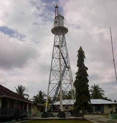
Teluk Palu Light, Donggala, January 2017
Radar Sulteng Online photo by Muhammed (no longer online)
Sulawesi Barat (West Sulawesi) Province Lighthouses Majene Regency Lighthouses * Tanjung Silopo (Polewali)
Date unknown. Active; focal plane about 16 m (52 ft); light characteristic unknown. Approx. 14 m (46 ft) square white skeletal tower with gallery. The tower is the right edge of Syahril Nasdem's 2018 photo and Google has a satellite view. Located on the quay of the Tanjung Silope harbor about 10 km (6 mi) southwest of Polewali. Site open, tower closed. Admiralty Q1500(?): there is no evident lighthouse at Polewali, where the Admiralty locates Q1500. NGA 25485. * Majene (2)
Date unknown. Active; focal plane about 25 m (82 ft); continuous white light (?). Approx. 22 m (72 ft) square white skeletal tower with gallery mounted on a concrete platform supported by piles. Fadly Muh has a photo and Bing has a satellite view. NGA lists a tower only 6 m (20 ft) tall. Located on the quay at Majene. Site open, tower closed. Admiralty Q1498; NGA 25488. Tanjung Rangasa
Date unknown. Active; focal plane 105 m (344 ft); white flash every 5 s. 21 m (69 ft) white iron skeletal tower. No photo available but a Bing satellite view may show the station. Located on a prominent cape in Banggae, a town about 5 km (3 mi) southwest of Majene (Madjene). Site status unknown. ARLHS IDO-325; Admiralty Q1496; NGA 25492. Tanjung Binanga
Date unknown. Active; focal plane 24 m (79 ft); white flash every 6 s. Approx. 20 m (66 ft) square pyramidal skeletal tower, painted white. No photo available but Google has a satellite view. Located on a promontory at Palangpalang, about 40 km (25 mi) north of Majene (Madjene). Site probably open, tower closed. Admiralty Q1494; NGA 25494.
Tanjung Ongkone
Date unknown. Active; focal plane 14 m (46 ft); white flash every 4 s. 14 m (46 ft) square white skeletal tower. No photo available, but Bing has an indistinct satellite view. Located on a remote point of land about 40 km (25 mi) south of Mamuju. Site status unknown. Admiralty Q1493; NGA 25496.
Mamuju Regency: Mainland Lighthouses Tanjung Kai
Date unknown. Active; focal plane 16 m (52 ft); white flash every 5 s. 10 m (33 ft) round barbell-shaped white fiberglass tower. No photo available but Bing has a distant satellite view. Located on a sharp cape about 20 km (13 mi) southwest of Mamuju. Site status unknown. Admiralty Q1491; NGA 25502. Tanjung Rangas
Date unknown. Active; focal plane 99 m (325 ft); white flash every 6 s. 21 m (69 ft) white iron skeletal tower. Several coast guard station buildings. No photo available but Bing has a satellite view. Located on a prominent cape about 10 km (6 mi) northwest of Mamuju. Site status unknown. ARLHS IDO-324; Admiralty Q1490; NGA 25500. Simboro Mamuju North
Date unknown. Active; focal plane 13 m (43 ft); green flash every 5 s. 13 m (43 ft) square skeletal tower painted green and mounted on a square platform supported by piles. Etty Atthur has a distant view and Google has a street view and an indistinct satellite view. Note: NGA has reversed the Admiralty numbers of the two Mumuju lights. Located close offshore north of the Mumuju ferry harbor. Accessible only by boat. Site open, tower closed. Admiralty Q1490.15; NGA 25503. Simboro Mamuju (South)
Date unknown. Active; focal plane 15 m (49 ft); white flash every 3 s. 13 m (43 ft) square skeletal tower painted white. Google has a street view (also seen at right), but the tower is inconspicuous in Google's satellite view. Located on the quay of the Mumuju ferry harbor. Site open, tower closed. Admiralty Q1490.1; NGA 25503.5. Tanjung Lalereh
Date unknown. Active; focal plane 42 m (138 ft); white flash every 5 s. Approx. 38 m (125 ft) tapered square skeletal tower with lantern and gallery, painted white. Three blue-roofed coast guard station buildings. No photo available but Bing has a satellite view. Located on a cape about 80 km (50 mi) north of Mamuju. Site status unknown. Admiralty Q1485; NGA 25503.8. 
Simboro Mamuju Light, Mamuju, January 2016
Google Maps street view
Mamuju Regency: Balabalagan Islands Lighthouses Pulau Ambungi
Date unknown. Active; focal plane 33 m (108 ft); quick-flashing white light. 30 m (98 ft) skeletal tower, painted white. No photo available and the island is only a blur in Google's satellite view. The Balabalagan Islands are reefs and islets in Makassar Strait emerging from a dangerous reef extending southeastward from Borneo. Located on an island at the northwestern end of the Balabalagan group about 130 km (80 mi) southeast of Balikpapan. Accessible only by boat. Site status unknown. ARLHS IDO-190; Admiralty Q1486.4; NGA 24946. Kepulauan Balabalagan (Balabalagan Islands)
Date unknown. Active; focal plane 40 m (131 ft); three white flashes every 20 s. 40 m (131 ft) skeletal tower, painted white. No photo available but Bing has a satellite view. Located on the southeasternmost of the islands in the middle of the Makassar Strait about 175 km (110 mi) southeast of Balikpapan. Accessible only by boat. Site status unknown. ARLHS IDO-177; Admiralty Q1488.5; NGA 24944.
Mamuju Utara (North Mumuju) Regency Lighthouse Tanjung Pasangkayu (Pasaugkajoe)
Date unknown. Active; focal plane 56 m (184 ft); three white flashes every 24 s. 37 m (131 ft) skeletal tower with lantern and gallery, painted white. No photo available but Bing has a satellite view. Located on a promontory about 2.5 km (1.5 mi) west of Pasangkayu. Site status unknown. ARLHS IDO-044; Admiralty Q1484; NGA 25504.
Sulawesi Tengah (Central Sulawesi) Province West Coast Lighthouses Note: Despite its name Central Sulawesi Province is in the northern part of the island; it includes the southern half of the long northern peninsula. Its west coast faces the Strait of Makassar and, to the north, the Celebes Sea. Lighthouses of the province's east coast are described on the Northeastern Sulawesi page. Southern Donggala Regency (Palu Gulf) Lighthouses * Teluk Palu (Tanjung Karang, Palu Gulf)
1907. Active; focal plane 82 m (269 ft); four long (2 s) white flashes every 25 s. 21 m (69 ft) hexagonal white iron skeletal tower with lantern and gallery. Several coast guard station buildings. A photo is at the top of this page and Google has a good satellite view of the station. One of Indonesia's not-so-well-known Dutch lighthouses. Located on a prominent cape on the west side of the entrance to the narrow Palu Gulf, about 25 km (15 mi) northwest of Palu, the capital of Central Sulawesi. Site status unknown, but it should be possible to drive to this station from Palu. ARLHS IDO-339; Admiralty Q1476; NGA 25508.
Donggala
Date unknown. Active; focal plane 13 m (43 ft); white flash every 3 s. 11 m (36 ft) square white skeletal tower. Google has a distant street view and an indistinct satellite view. Located at the north end of the quay at Donggala, on the northwest coast of the Palu Gulf. Site status unknown. Admiralty Q1478; NGA 25510. Pantai Taipa (Taipa Beach)
Date unknown. Active; focal plane about 15 m (49 ft); light characteristic unknown. Approx. 15 m (49 ft) square skeletal tower mounted on a square platform supported by piles. Miloslav Petrtyl has a photo, Anastasiya Ivanova has a second photo (a portion is seen at right), and Bing's indistinct satellite view shows the platform. Located just offshore on the southeast coast of the Palu Gulf. Easily seen from shore. Site open, tower closed. Admiralty Q1481.2. Taipa Jetty
Date unknown. Active; focal plane about 15 m (49 ft); light characteristic unknown. Approx. 13 m (43 ft) round barbell-shaped white fiberglass tower. A small photo is available and Bing has a satellite view. Located just north of the ferry pier at Taipa. Site open, tower closed. Admiralty Q1481. * Pantoloan
Date unknown. Active; focal plane 18 m (59 ft); white flash every 5 s. 15 m (49 ft) square white skeletal tower mounted on a square white equipment shelter. The tower is the far right in a photo of the port by Bagus Roby and Bing has a distant satellite view. NGA spells the name as Panteluan. Located at the south end of the quay at Pantoloan, a port on the east side of the Palu Gulf. Site open, tower closed. Admiralty Q1480; NGA 25512. 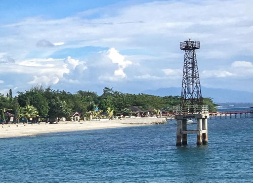
Pantai Taipa Light, Palu Gulf, November 2016
Google Plus photo by Anastasia Ivanova
Northern Donggala Regency Lighthouses Tanjung Manimbaya
Date unknown. Active; focal plane 50 m (164 ft); two white flashes every 20 s. 40 m (131 ft) square skeletal tower with lantern and gallery; tower painted white, lantern red. Three coast guard station buildings. A closeup photo is available and Google has a satellite view of the station. This lighthouse is built almost precisely on the Equator. Located at the tip of a long promontory extending into the Strait of Makassar about 30 km (19 mi) northwest of Mapaga. Site status unknown. Admiralty F2040; NGA 25114. Pulau Tuguan (Pulau Tugguan, Noordwachter)
1902. Active; focal plane 92 m (302 ft); white flash every 5 s. 20 m (66 ft) white iron skeletal tower. The modern description is consistent with the Dutch original. No photo available and a cloud hides the station in Google's satellite view of the island. Not to be confused with another, better known Noordwachter in the Java Sea. Located on an island in the strait about 25 m (15 mi) northwest of Munte in northwestern Sulawesi. Accessible only by boat. Site status unknown. ARLHS IDO-031; Admiralty F2044; NGA 25120. * Ogoamas
Date unknown. Active; focal plane about 18 m (59 ft); light characteristic unknown. Approx. 15 m (49 ft) square white skeletal tower. The top of the lighthouse is at the right in a photo of the port by Ar Rahman Ar Rahim and Google has a street view and a fuzzy satellite view. Located on the waterfront at Ogoamas. Site open, tower closed. Admiralty F2044.8.
Tolitoli Regency Lighthouses
Lingian
Date unknown. Active; focal plane 15 m (49 ft); white flash every 3 s. 15 m (49 ft) square white skeletal tower mounted on a platform suported by piles. No photo available but Bing has a distant satellite view. Located on the northwest tip of a large reef off Tanjung Aga, about 25 km (15 mi) southwest of Pulau Simatang. Accessible only by boat. Site open, tower closed. Admiralty F2045; NGA 25119. * Pulau Simatang (Sematan)
Date unknown. Active; focal plane 31 m (102 ft); two white flashes every 8 s. NGA has no description of this light, but a tall tower would be needed here. No photo available but Google has a satellite view. Located at the northern tip of Pulau Simatang. Accessible only by boat. Site status unknown but certainly the light can be seen from nearby, tower closed. Admiralty F2046; NGA 25118. Pulau Kabetan (Pulau Kapetan, Tanjung Paligisan)
Date unknown. Active; focal plane 31 m (102 ft); white flash every 10 s. Approx. 28 m (92 ft) skeletal tower with gallery. Lighthouse painted white. A photo is at right and Google has a satellite view. Located on the southeastern tip of Pulau Kabetan, an island on the approach to Botakna Bunga. Accessible only by boat. Site status unknown. Admiralty F2047; NGA 25121. Pulau Lutungan
Date unknown. Active; focal plane 45 m (148 ft); two white flashes every 8 s. Approx. 25 m (82 ft) skeletal tower with gallery. Lighthouse painted white. No photo available but Google has a satellite view. NGA spells the name Latungan. Located at the northern tip of Pulau Lutungan, an island in the entrance to the harbor of Tolitoli. Accessible only by boat. Site status unknown. Admiralty F2047.5; NGA 25122. 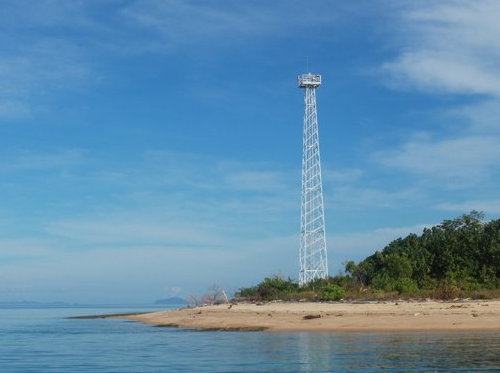
Pulau Kabetan Light, Tolitoli
unattributed photo from identitastolitoli.com (no longer online)
* Tolitoli
Date unknown. Active; focal plane about 14 m (46 ft); green light, pattern unknown. Approx. 12 m (39 ft) skeletal tower, painted white. Google has a satellite view and the top of the tower peeks above a tree in Google's street view. Located at the older ferry terminal l in Tolitoli. Site open, tower closed. Admiralty F2047.8. * Tanjung Labuan Dedeh
Date unknown. Active; focal plane 16 m (52 ft); white flash every 3 s. 15 m (49 ft) skeletal tower, painted white. Novander Ulag has a photo, Denny Setiawan has a view from the sea, and Google has a fuzzy satellite view. Located at the newer ferry terminal in Tolitoli. Site open, tower closed. Admiralty F2048; NGA 25116. Pulau Salando (Tanjung Malagka, Pulau Silando Timur, Stroomenkaap) (2)
Date unknown (station established 1913). Active; focal plane 57 m (187 ft); white flash every 5 s. 25 m (82 ft) white iron skeletal tower. A photo is at right, Paul Johan Lumatalale has a 2018 view, and Google has an indistinct satellite view. This lighthouse marks the northeastern entrance to the Strait of Makassar. The original lighthouse had a focal plane height of 46 m (151 ft). Located on an island just off Tanjung (cape) Malagka, the northwestern corner of Sulawesi. Accessible only by boat. Site status unknown. ARLHS IDO-312; Admiralty F2050; NGA 25112. Pulau Dolongan
Date unknown. Active; focal plane 23 m (75 ft); white flash every 6 s. 23 m (75 ft) square white skeletal tower mounted on a platform supported by piles. No photo available but Google has a fuzzy satellite view. This light faces the Celebes Sea, marking the extreme northwest corner of Sulawesi. Located off the northern tip of an island about 10 km (6 mi) northeast of Tanjung Malagka. Site status unknown. Admiralty F2051; NGA 25111.7. 
Pulau Salando Light, August 2013
Panoramio photo copyright Roly R; used by permission
Buol Regency North Coast Lighthouses
Tanjung Kandi
Date unknown. Active; focal plane 120 m (394 ft); three white flashes every 20 s. Approx. 65 m (213 ft) square skeletal tower with lantern and gallery. Lighthouse painted white, lantern red. Four 1-story station buildings. Simon Potter has a view from the sea (also seen at right) and Google has a good satellite view. Located on a very prominent cape about 65 km (40 mi) east of Pulau Dolongan. Site status unknown. Admiralty F2052; NGA 25113. * Leok
Date unknown. Active; focal plane 18 m (59 ft); white flash every 4 s. 15 m (49 ft) square white skeletal tower. Yonnas Grey has a view from the sea and Google has a street view and a satellite view. Located at the ferry terminal in Leok, a fishing port about 15 km (9 mi) south of Tanjung Kandi. Site open, tower closed. Admiralty F2054; NGA 25124.
Information available on lost lighthouses:
Notable faux lighthouses:

Tanjung Kandi Light, April 2010
ex-Panoramio photo by Simon Potter
Lighthouses of Indonesia: Talaud and Sangihe Islands
Indonesia has been independent since 1945 after having been the Dutch East Indies for more than 350 years. It is a huge country, stretching along both sides of the Equator for more than 46 degrees of longitude (roughly 5100 km or 3200 miles). Comprised of some 17,000 islands (more than 6000 inhabited islands), it has hundreds of major aids to navigation. This page includes the lighthouses of the Talaud and Sangihe Islands, which lie between Sulawesi (Celebes) and the southern Philippine island of Mindanao. The island chain separates the Philippine Sea to the east from the Celebes Sea to the west.
The Talaud and Sangihe Islands are administered as three regencies of Sulawesi Utara (North Sulawesi) Province. Although they are remote, they are well populated, with a total population of about 275,000.
The Indonesian word for a lighthouse is mercusuar. The phrase menara suar, which includes the Arabic word menara, is sometimes used instead. Tanjung and ujung are words for capes, pulau is an island, selat is a strait, karang is a reef, gosong is a shoal or sandbar, teluk is a bay or harbor, and pelabuhan is a port.
Aids to navigation in Indonesia are operated and maintained by the Directorate General of Sea Navigation.
ARLHS numbers are from the ARLHS World List of Lights. Admiralty numbers are from volume F of the Admiralty List of Lights & Fog Signals. U.S. NGA List numbers are from Publication 112. General Sources Online List of Lights - Indonesia - Vol. F
Coming soon: photos by various photographers posted by Alexander Trabas. Indonesian Lighthouses
Historic postcard views from the collection of Michel Forand. World of Lighthouses - Indonesia
Photos by various photographers available from Lightphotos.net. GPSNavigationCharts
Navigational chart for the islands. 
Pulau Miangas Light, May 2008
photo copyright Ferdi Rosman; permission requested
Kepulauan Talaud (Talaud Islands) Regency Lighthouses The Talaud Islands are the northeasternmost islands of North Sulawesi, located in the Philippine Sea northeast of the Sangihe Islands and southeast of Mindanao in the Philippines. The islands are quite remote but they are well populated with a population of more than 80,000. Pulau Karakelong is by far the largest of the islands and has most of the population.
Pulau Miangas Lighthouse Pulau Miangas (Isla Palmas) (2?)
Date unknown. Active; focal plane 130 m (427 ft); three white flashes every 20 s. 30 m (98 ft) square skeletal tower with gallery, painted white. Several coast guard station buildings. Ferdi Rosman's photo at the top of this page came from a portfolio of photos that is no longer online; this collection suggested that the present tower is relatively new. Charles Buts has a street view taken from the top of the tower, and Bing has a satellite view. The station buildings are about 300 m (1000 ft) downhill southwest of the tower. Pulau Miangas is a small island isolated in the Philippine Sea about 125 km (75 mi) east of the southern tip of Mindanao. Known as Isla Palmas in the Philippines, the island was claimed by the U.S. as part of the Philippines in the early 1900s, but in 1928 the Permanent Court of Arbitration ruled in favor of the Netherlands. Indonesia maintains sovereignty as successor to the Dutch. A settlement on the island has a population of about 700. Note: NGA and ARLHS list this light under the Philippines, but the Admiralty has it placed properly in Indonesia. Located at the highest point of the island. Site open, tower closed. ARLHS PHI-112; Admiralty F2138; NGA 15156.
Nanusa Islands Lighthouses These are small islands located about 30 km (19 mi) northeast of Pulau Karakelong
Pulau Marampit
2006. Active; focal plane 45 m (148 ft); two white flashes every 12 s. 40 m (131 ft) square skeletal tower with lantern and gallery, painted white and mounted atop a 2-story coast guard station building. Rizki Bachtiar's photo is at right, Izzuddin Abdul Aziz has a 2018 photo, and Google has a satellite view of the station. Located at the northern tip of an island about 10 km (6 mi) northeast of Keratung. Site status unknown. Admiralty F2134.2. * Pulau Karatung
Date unknown. Active; focal plane 12 m (39 ft); white flash every 3 s. 10 m (33 ft) round hourglass-shaped white fiberglass tower, mounted on a square concrete base. Ferdi Rosman Feizal has a photo, a very distant view is available, and the shadow of the tower is seen in Google's satellite view. This light is similar to many harbor lights in Indonesia's out islands. Pulau Karatung is a small but inhabited island about 50 km (30 mi) northeast of the northern tip of Pulau Talaud. Accessible only by boat. Site status unknown. Admiralty F2134; NGA 25199. Pulau Intata
Date unknown (2006 or later). Active; focal plane 55 m (180 ft); two white flashes every 10 s. 30 m (98 ft) square skeletal tower with gallery, painted white. Ferdi Rosman Feizal's early 2006 photo of the island does not show a lighthouse, but it was seen in Dandi Ratri Antoro's 2012 photo (no longer online) and Google has a satellite view. Located on a small island about 15 km (9 mi) south of Pulau Marampit. Accessible only by boat. Site status unknown. Admiralty F2133.9. Pulau Kakarutan (Kakorotan)
Date unknown. Active; focal plane 45 m (148 ft); two white flashes every 10 s. 30 m (98 ft) square skeletal tower with gallery, painted white. No photo available but Google has a satellite view. Located on the east side of a small island only 2.5 km (1.5 mi) south of the Pulau Intata lighthouse. Accessible only by boat. Site status unknown. Admiralty F2133.8.
Pulau Karakelong Lighthouses Tanjung Ambora
Date unknown. Active; focal plane 42 m (138 ft); three white flashes every 20 s. 40 m (131 ft) square skeletal tower with lantern gallery. Tower painted white, lantern red. Several station buildings. No photo available but Google has a satellite view of the station. Located at the northwestern tip of Pulau Karakelong. Site status unknown. Admiralty F2132; NGA 25202. 
Pulau Marampit Light, Talaud Islands, July 2012
photo copyright Rizki Bachtiar; permission requested
* Pelabuhan Gunaloh
2016. Active; focal plane 17 m (56 ft); white flash every 3 s. 10 m (33 ft) tower described as a white beacon, probably a square white skeletal tower. No photo available but Bing has an indistinct satellite view. This is a new port; it was not seen at all in an earlier Bing satellite view. Located on the northeastern coast of Pulau Karakelong. Site open, tower closed. Admiralty F2132.4. * Pelabuhan Melonguane
Date unknown. Active; focal plane about 14 m (46 ft); light characteristic unknown. Approx. 12 m (39 ft) square white skeletal tower. A photo is available, Charles Buts has a street view from the pier, and Google has an indistinct satellite view. Located on the waterfront of Melonguane, a town at the south end of Pulau Karakelong. Site open, tower closed. Admiralty F2129.8. * Teluk Beo Beo (2)
Date unknown. Active; focal plane 19 m (62 ft) (?); continuous red light. NGA lists a white metal mast but the light appears to be on a much taller skeletal tower. Novry Morong has a distant view and Bing has a satellite view. Located near the waterfront in Beo, on the west coast of Pulau Karakelong. Site open, tower closed. Admiralty F2130, NGA 25204. * Pelabuhan Essang
Date unknown. Active; focal plane about 18 m (59 ft); white flash every 3 s. Approx. 15 m (49 ft) square white skeletal tower mounted on a square 1-story equipment shelter. A photo is available and Bing has an indistinct satellite view. Located on the quat at Essang, a small port on the northwestern coast of Pulau Karakelong. Site open, tower closed. Admiralty F2132.2.
Pulau Salebabu and Pulau Kaburuang Lighthouses
Tanjung Salonggaka
Date unknown. Active; focal plane 20 m (66 ft); two white flashes every 6 s. Described only as a "white beacon." No photo available but Google has a satellite view. Located at the northern tip of Pulau Salebabu, a smaller island south of Pulau Karakelong. Accessible only by boat. Site status unknown. Admiralty F2132.5; NGA 25198.5. * Lirung
Date unknown. Active; focal plane 12 m (39 ft); white flash every 3 s. 10 m (33 ft) round hourglass-shaped white fiberglass tower with one black horizontal band. A 2019 photo is available, the light is at the left edge of Sukur Mana's photo of the waterfront, and Google has a distant satellite view. Located on the waterfront of Lirung, a town on the east coast of Pulau Salebabu. Site open, tower closed. Admiralty F2133; NGA 25198. * Mangaran
Date unknown. Active; focal plane about 20 m (66 ft); light characteristic unknown. Approx. 15 m (49 ft) square white skeletal tower mounted on a 1-story white equipment building. A portion of Rully Setiawan Dewanda's photo is at right but the tower is inconspicuous in Bing's satellite view. Located at a pier near the northern tip of Pulau Kaburuang, an island southeast of Pulau Salebahu. Site open, tower closed. Admiralty F2133.3. Tanjung Pallo (Palle)
Date unknown. Active; focal plane 65 m (213 ft); white flash every 10 s. 40 m (131 ft) octagonal white concrete tower with lantern and gallery. No photo available but Google has a satellite view of the station. Located at the southern tip of Pulau Kaburuang, marking the south end of the Talaud Islands. Site status unknown. ARLHS IDO-318; Admiralty F2133.5; NGA 25197.8. 
Mangaran Light, Talaud Islands, August 2017
Google Plus photo by Rully Setiawan Dewanda
Kepulauan Sangihe (Sangihe Islands) Regency Lighthouses The Sangihe Islands are a chain of volcanic islands extending almost due north from the northeastern tip of Sulawesi. The islands form the dividing line between the Celebes Sea to the west and the Philippine Sea to the east. In 2007 the Sangihe Islands Regency was divided, placing the southern half of the island chain in the new Sitaro Islands Regency.
Marore (Kawio) Islands Lighthouses Note: These are small islands at the extreme northern end of the Sangihe chain, west of the Talaud Islands.
Pulau Batubawaikang
Date unknown. Active; focal plane 13 m (43 ft); white flash every 3 s. 13 m (43 ft) square skeletal tower mounted on a square 1-story equipment shelter, all on a square platform supported by concrete piers. Izzuddin Abdul Aziz has a 2018 photo (also seen at right) but the tower is hard to find in Bing's satellite view. This light marks the extreme northern end of the island chain. Located on an islet just off the northern tip of Pulau Marore. Accessible only by boat. Admiralty F2135.3. Pulau Marore (Pulau Maru)
Date unknown. Active; focal plane 180 m (591 ft); two white flashes every 10 s. 40 m (131 ft) square skeletal tower with lantern and gallery. Tower painted white, lantern red. Several station buildings. Ferdi Rosman Feizal has a very distant view, and Bing has a satellite view of the station. Pulau Marore is the Indonesia's northernmost island in the Celebes Sea, located about 90 km (55 mi) south of Mindanao in the Philippines. Accessible only by boat. Site status unknown. Admiralty F2135; NGA 25200. Pulau Kawio
2006. Active; focal plane 50 m (164 ft); two white flashes every 10 s. 30 m (98 ft) square skeletal tower with gallery, painted white. Two station buildings. A very distant view is available (first photo, lighthouse to the left on the island) and Bing has a satellite view of the station. Located on a small island about 10 km (6 mi) southwest of Pulau Marore. Accessible only by boat. Site status unknown. Admiralty F2134.8; NGA 25200.2. Pulau Kemboling
2006. Active; focal plane 52 m (171 ft); white flash every 6 s. 10 m (33 ft) square white skeletal tower. No photo available but Bing has an indistinct satellite view. Located at the southern tip of an island just to the south of Pulau Kawio. Accessible only by boat. Site status unknown. Admiralty F2134.5; NGA 25200.5. Pulau Matutuang
Date unknown. Active; focal plane 107 m (351 ft); white flash every 5 s. Approx. 35 m (115 ft) tapered square skeletal tower with gallery, painted white. Several station buildings. A photo shows both of the island's lighthouses, a very distant view from the sea (lighthouse to the left on the island) is available and Bing has a satellite view of the station. Located on an isolated high island near the northern end of the Sangihe chain, about 40 km (25 mi) southeast of Pulau Kawio. Accessible only by boat. Site status unknown. ARLHS IDO-220; Admiralty F2135.5; NGA 25201. 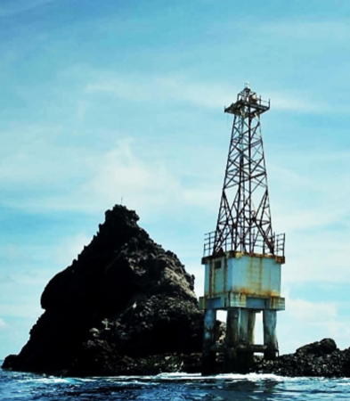
Pulau Batubawaikang Light, Kawio Islands, July 2018
Google Maps photo by Izzuddin Abdul Aziz
Pelabuhan Matutuang
Date unknown. Active; focal plane about 18 m (59 ft); light characteristic unknown. Approx. 15 m (49 ft) square skeletal tower painted white. A view from the sea and a second view are available and Bing has an indistinct satellite view. Located at the base of the pier on Pulau Matutuang. Site open, tower closed. Admiralty F2135.7. Pulau Kawaluso (Kawalusu)
Date unknown. Active; focal plane about 60 m (197 ft); white flash every 8 s. Approx. 25 m (82 ft) square white skeletal tower. A photo is available and Bing has an indistinct satellite view. Located on the southwesternmost of the Marore islands. Accessible only by boat. Site status unknown. Admiralty F2136; NGA 25197.5.
Pulau Sangihe (Sangir Besar) Area Lighthouses Pulau Sangihe, also known as Sangir Island, is by far the largest island of the chain; it is 40 km (25 mi) long and about 8 km (5 mi) wide. It is the site of the active Mount Awu volcano, which erupted disastrously in 1856 and most recently in 2004. Pulau Lipang
2016. Active; focal plane 15 m (49 ft); white flash every 5 s. 10 m (33 ft) square skeletal tower painted white. Ardi Ogelang has posted a photo on Twitter, and a distant view (second photo on the page) is available, but the light is probably too new to appear in Bing's satellite view of the port. Located at the foot of the pier on Pulau Lipang, a small island about 20 km (13 mi) northwest of Pulau Sangihe. Site open, tower closed. Admiralty F2127.8.
Pulau Buang (Salehe)
Date unknown. Active; focal plane 80 m (262 ft); two white flashes every 10 s. Approx. 30 m (98 ft) skeletal tower, painted white. The lighthouse is a ghostly presence in Ferdi Rosman Feizal's distant view of the island, and also in a second view and a third view, and Bing has an indistinct satellite view. Located on an island about 35 km (22 mi) northeast of the northern point of Pulau Sangihe, the central island of the archipelago. Accessible only by boat. Site status unknown. Admiralty F2128; NGA 25197. Pulau Manipa
Date unknown. Active; focal plane 69 m (226 ft); white flash every 10 s. 30 m (98 ft) white concrete tower with lantern and gallery. David Vilabella's view from the sea is at right and Google has a satellite view. Located near the southwestern tip of an island off the north end of Pulau Sangihe. Site status unknown. ARLHS IDO-218; Admiralty F2127.5; NGA 25196.5. Pulau Benglaut (Pulau Beng)
Date unknown. Active; focal plane 106 m (348 ft); white flash every 5 s. 10 m (33 ft) round white fiberglass tower. No photo available but Google has a satellite view. Located at the east end of Pulau Benglaut, a small high island off the southeast coast of Pulau Sangihe. Accessible only by boat. Site status unknown. Admiralty F2127; NGA 25194. Tanjung Toademanandu
Date unknown. Active; focal plane 20 m (66 ft); white flash every 3 s. Approx. 15 m (49 ft) square skeletal tower mounted on a square 1-story equipment shelter. Entire lighthouse is white. Rama Dalvin has a 2018 photo and Google has a satellite view. Located on a prominent cape at the southwestern end of Pulau Singihe. Site status unknown. Admiralty F2120.5; NGA 25188. 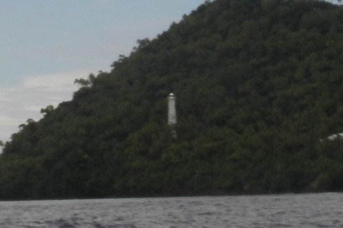
Pulau Manipa Light, August 2010
ex-Panoramio photo copyright David Vilabella; used by permission
Tanjung Bunakeng (Tahuna, Pulau Sangihe)
Date unknown. Active; focal plane 130 m (427 ft); white flash every 3 s. 30 m (98 ft) square skeletal tower, painted white. No photo available but Google has a satellite view of the station. Located on heights at the southern entrance to the harbor of Tahuna, the principal town on the west coast of Pulau Sangihe. Site status unknown. Admiralty F2123; NGA 25190. * Teluk Tahuna (Pulau Sangihe)
Date unknown. Active; focal plane 32 m (105 ft); two white flashes every 8 s. 30 m (98 ft) skeletal tower, painted white. Romandito Mahendrayudha has a photo, Charles Buts has a street view, and Google has a satellite view. Located near the waterfront in Tahuna. Site open, tower closed. Admiralty F2123.5. * Pelabuhan Tua Tahuna
Date unknown. Active (privately maintained and probably unofficial); focal plane about 20 m (66 ft); continuous white light. Approx. 15 m (49 ft) square tower; upper half painted red and lower half elaborately decorated. A 2019 photo is available and Don Kalangit has a photo of the light in action; Google has an indistinct satellite view. The light is provided by two powerful spotlights. The Admiralty lists a light (F2124, NGA 25192) at a focal plane of 32 m (105 ft), apparently on the hillside behind the town. That light has not been located. The Pelabuhan light is on the waterfront of a port on the north side of Tahuna Bay. Site open, tower closed. * Pulau Kahakitang
Date unknown. Active; focal plane 15 m (49 ft); white flash every 3 s. Approx. 12 m (39 ft) square skeletal tower painted white and mounted on a square 1-story equipment shelter. An aerial view is available and Bing has a satellite view. Located at the base of the pier on Pulau Kahakitang, an island about 25 km (15 mi) south of Pulau Sangihe. Site open, tower closed. Admiralty F2120.45. * Pulau Para
Date unknown. Active; focal plane 16 m (52 ft); white flash every 3 s. Approx. 13 m (43 ft) square skeletal tower painted white and mounted on a square 1-story equipment shelter. Don Kalangit has a 2019 photo and Google has a satellite view. Located at the base of the pier on Pulau Para, an island about 35 km (22 mi) south of Pulau Sangihe. Site open, tower closed. Admiralty F2120.4.
Kepulauan Sitaro (Sitaro Islands) Regency Lighthouses Separated from the Sangihe Islands Regency in 2007, this regency includes a chain of small volcanic islands between Pulau Sangihe and the northeastern tip of Sulawesi. Siau is the largest and most populated island.
Pulau Makalehi Lighthouses
Pulau Makalehi
Date unknown. Active; focal plane 150 m (492 ft); two white flashes every 10 s. 40 m (131 ft) square skeletal tower with lantern and gallery, painted white and mounted on a large station building. Ronny Buol's photo is at right and Google has a satellite view. Makalehi is a tall, currently inactive volcanic cone about 25 km (15 mi) west of Pulau Siau, one of the larger islands of the Sangihe chain. Located on the southern slope of the volcano. Accessible only by boat. Site status unknown. Admiralty F2120.3. * Pelabuhan Makalehi
Date unknown. Active; focal plane 15 m (49 ft); white light, 2 s on, 1 s off. Approx. 11 m (36 ft) square white skeletal tower with gallery. A distant view from the sea is available and Bing has an indistinct satellite view. Located a short distance north of the pier on Makalehi. Site open, tower closed. Admiralty F2120.25.
Pulau Siau Area Lighthouses * Pehe
Date unknown. Active; focal plane about 16 m (52 ft); white light, 2 s on, 1 s off. Approx. 12 m (39 ft) square white skeletal tower mounted on a square 1-story equipment shelter. A 2018 photo is available, Charles Buts has a distant street view from across the harbor and Google has a satellite view. The street view also shows the relentlessly active volcano Karangetang. Located at the north end of the waterfront at Pehe, a village on the west coast of Pulau Siau. Site open, tower closed. Admiralty F2120.2. Pehe Entrance South
Date unknown. Active; focal plane about 16 m (52 ft); green light, pattern unknown. Approx. 16 m (52 ft) square skeletal tower mounted on a square 1-story equipment shelter, all on a platform supported by piles. The light is seen at the left in a street view by Charles Buts, George Meikalz has a very distant view, and Google has an indistinct satellite view. This light and the next one warn ships away from reefs on both sides of the entrance to Pehe. Located about 500 m (0.3 mi) west of the Pehe waterfront. Accessible only by boat. Site open, tower closed. Not listed by the Admiralty. Pehe Entrance North
Date unknown. Active; focal plane about 16 m (52 ft); red light, pattern unknown. Approx. 16 m (52 ft) square skeletal tower mounted on a square 1-story equipment shelter, all on a platform supported by piles. A view from the Pehe pier is available, the light is seen at the right in a street view by Charles Buts and Google has an indistinct satellite view. 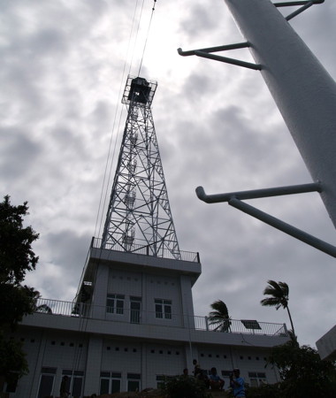
Pulau Makalehi Light, Sitaro Islands, November 2008
photo copyright Ronny Buol; used by permission
* Ulu
Date unknown. Active; focal plane 15 m (49 ft); white flash every 3 s. 13 m (43 ft) round barbell-shaped white fiberglass tower, mounted on a square concrete base. Alfred Pahala has a photo, Ferdi Rosman Feizal has a photo, Wuntat Widi has a 2018 street view, Charles Buts has an evening street view from the pier, and Google has an indistinct satellite view. This light is similar to many harbor lights in Indonesia's out islands. Located on the waterfront of Ulu, a settlement on the east coast of Pulau Siau. Site open, tower closed. Admiralty F2120; NGA 25184. Karang Pihise (Pihise Reef)
Date unknown. Active; focal plane 12 m (39 ft); white flash every 3 s. 12 m (39 ft) square white skeletal tower mounted on a platform supported by piles. No photo available but Google has a distant satellite view. This light guides ships in the narrow strait between Pulau Siau and Pulau Pahepa. Located on the southwestern tip of Pulau Siau. Accessible only by boat. Site open, tower closed. Admiralty F2118. Pulau Mahoro (Mahora)
Date unknown. Active; focal plane 80 m (262 ft); two white flashes every 8 s. Approx. 20 m (66 ft) square skeletal tower with gallery, painted white. No photo available but Bing has a satellite view. Located on the eastern tip of Pulau Mahoro, a small island off the southeast end of Pulau Siau. Accessible only by boat. Site status unknown. Admiralty F2119; NGA 25186.
Pulau Tahulandang Area Lighthouses
* Buhias (Pulau Tahulandang) (2?)
Date unknown (since 2010). Active; focal plane 14 m (46 ft); white flash every 3 s. 12 m (39 ft) square skeletal tower painted white. A portion of L.S. Sirapanji's view from the harbor is at right, Nando Pindha Pamungkas has a second view and a distant view (halfway down the page) is available, but the tower is not seen in Google's fuzzy satellite view and a cloud blocks Bing's satellite view. NGA lists a 12 m (39 ft) post. Located at the base of the pier on Pulau Tahulandang, an island about 35 km (22 mi) south of Pulau Siau and near the south end of the Sangihe chain, about 90 km (55 mi) north northeast of Tanjung Arus. Site open, tower closed. Admiralty F2116; NGA 25180. Pulau Pasige
Date unknown. Active; focal plane 15 m (49 ft); white flash every 2.5 s. 15 m (49 ft) round hourglass-shaped white fiberglass tower, mounted on a square platform supported by piles. No photo available but Bing has a satellite view. Located on a reef off the southwest side of a small island west of Pulau Tahulandang. Accessible only by boat. Site status unknown. Admiralty F2114; NGA 25176.
Pulau Biaro Lighthouse * Pulau Biaro
Date unknown. Active; focal plane about 16 m (52 ft); light characteristic unknown. Approx. 12 m (39 ft) square white skeletal tower. Billy Tamesala has a distant view (lighthouse is seen at upper right) and Google has a satellite view. Pulau Biaro is the southernmost of the inhabited islands in the Sangihe chain. Located at the ferry terminal. Site open, tower closed. Admiralty F2115. 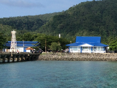
Buhias (Pulau Tahulandang) Light, Sitaro Islands, October 2017
ex-Google Plus photo by L.S. Sirapanji
Information available on lost lighthouses:
Notable faux lighthouses:
Tuesday, January 28, 2020
LightHouse Celebes and surroundings
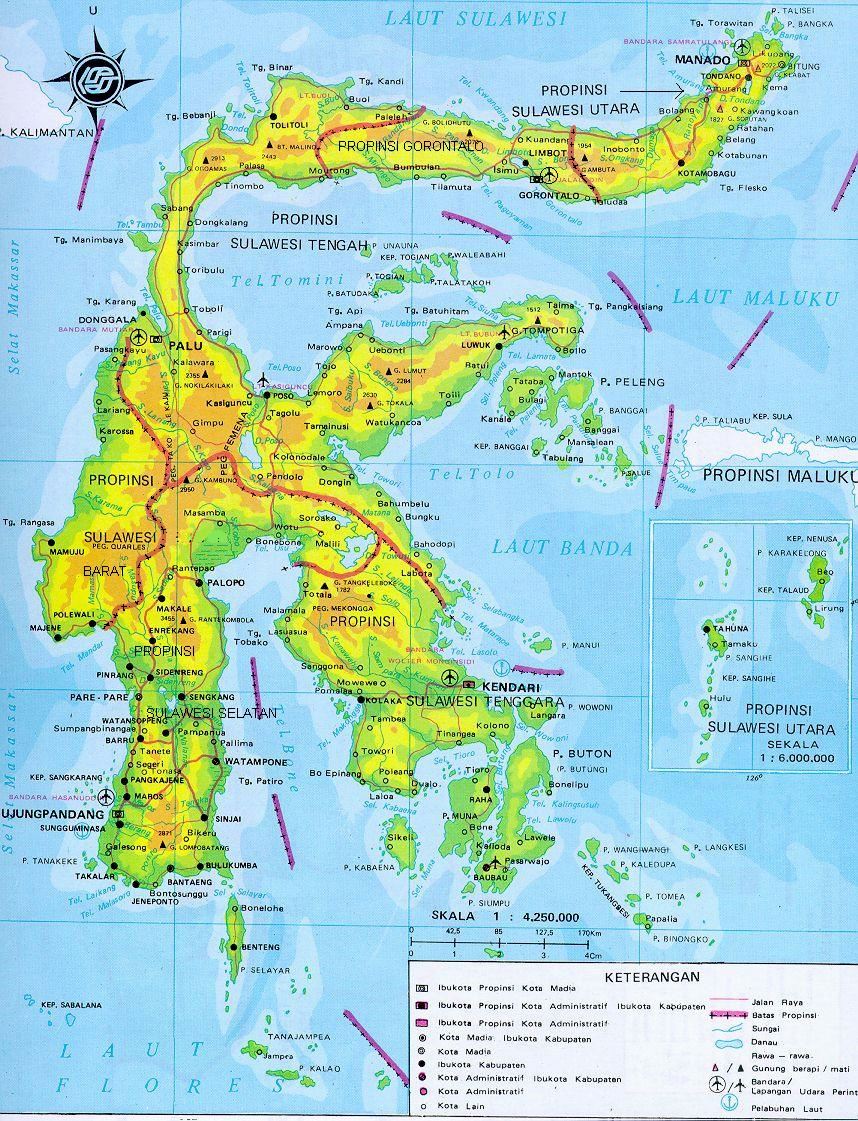
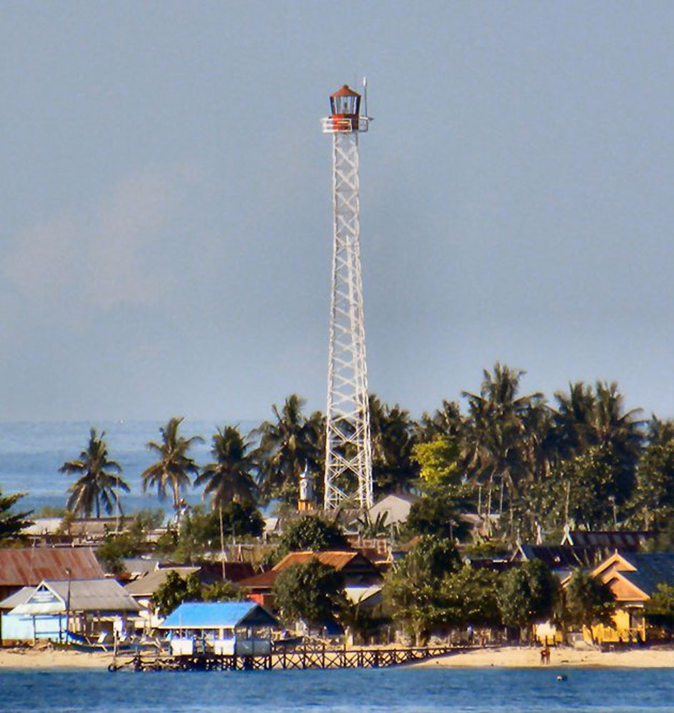
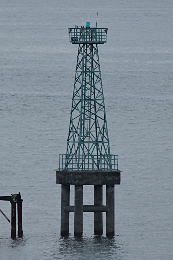
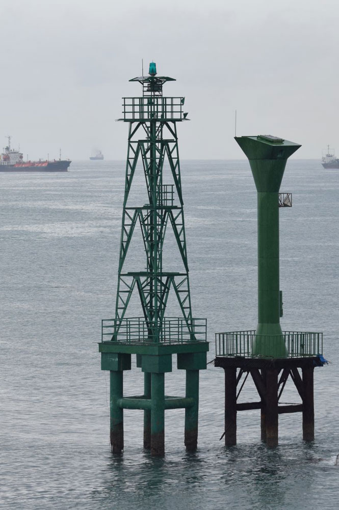
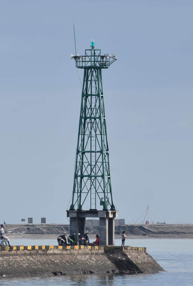
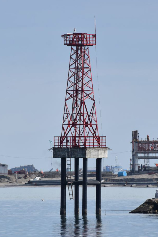
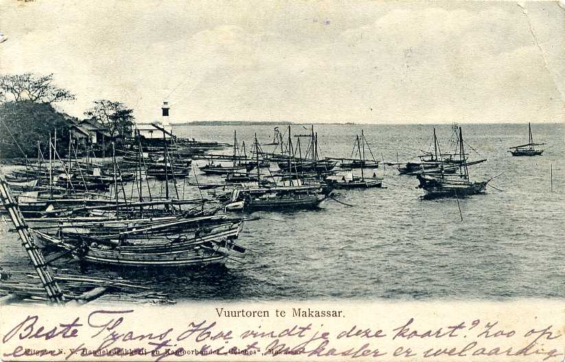
Subscribe to:
Post Comments (Atom)
No comments:
Post a Comment