
Lighthouses of Indonesia: Eastern Kalimantan (Borneo)
Indonesia has been independent since 1945 after having been the Dutch East Indies for more than 350 years. It is a huge country, stretching along both sides of the Equator for more than 46 degrees of longitude (roughly 5100 km or 3200 miles). Comprised of some 17,000 islands (more than 6000 inhabited islands), it has hundreds of major aids to navigation. Unfortunately it's not easy to tell how many of these aids can be considered lighthouses. Information about them is scarce and photos are scarcer. Official light lists contain dozens of entries for "framework towers" and "white beacons," providing little guidance for the lighthouse fan.
Borneo, known as Kalimantan in Indonesia, is the world's third largest island. 73% of the island is Indonesian; the remaining portion includes the Malaysian states of Sarawak and Sabah and the independent sultanate of Brunei. This page describes lighthouses of eastern Kalimantan including the provinces of North Kalimantan and East Kalimantan.
The Indonesian word for a lighthouse is mercusuar. The phrase menara suar, which includes the Arabic word menara, is sometimes used instead. Tanjung and ujung are words for capes, pulau is an island, selat is a strait, karang is a reef, gosong is a shoal or sandbar, teluk is a bay or harbor, and pelabuhan is a port.
Aids to navigation in Indonesia are operated and maintained by the Directorate General of Sea Navigation.
ARLHS numbers are from the ARLHS World List of Lights. Admiralty numbers are from volumes F and Q of the Admiralty List of Lights & Fog Signals. U.S. NGA List numbers are from Publication 112. General Sources Online List of Lights - Indonesia - Vol. F and Vol. Q
Coming soon: photos by various photographers posted by Alexander Trabas. Indonesian Lighthouses
Historic postcard views from the collection of Michel Forand. World of Lighthouses - Indonesia
Photos by various photographers available from Lightphotos.net. GPSNauticalCharts
Navigational chart information for eastern Kalimantan. Kalimantan Timur Map
A useful map of eastern Kalimantan. 
Karang Unarang Light, Ambalat Block
Indonesian Navy photo
Kalimantan Utara (North Kalimantan) Province Lighthouses Nunukan Regency Lighthouses
Pulau Sebatik (Sebatik Island)
Date unknown. Active; focal plane 42 m (138 ft); two white flashes every 12 s. 40 m (131 ft) square skeletal tower with gallery. A 2017 photo is at right, a 2019 photo is available, and Google has a satellite view. This lighthouse is very close to the Malaysian border, leading to some confusion: the NGA list and Bing Maps have the lighthouse in Malaysia while the Admiralty and Google Maps have it in Indonesia. It is clearly an Indonesian lighthouse. Located on the east side of the island of Sebatik, which is divided in half by the international border. Site open, tower closed. Admiralty F1999.3; NGA 24731. Pulau Sebatik West
Date unknown. Active; focal plane about 16 m (52 ft); light characteristic unknown. Approx. 16 m (52 ft) square skeletal tower mounted on a square platform supported by piles. No photo available but Google has a fuzzy satellite view. This light marks the international border on the west side of Sebatik Island. Located just offshore. Accessible only by boat. Site open, tower closed. Admiralty F1999.4. Tanjung Harapan (Pulau Nunukan Timur)
Date unknown. Active; focal plane 15 m (49 ft); red flash every 5 s. 15 m (49 ft) skeletal tower mounted on a platform supported by piles. Entire lighthouse is red. No photo available but Google has a distant satellite view. The light guides vessels into the strait between Pulau Sebatik and Pulau Nunukan. Located just off the eastern tip of Pulau Nunukan. Accessible only by boat.Site open, tower closed. Admiralty F1999.6; NGA 24744. Gosong Nunukan
Date unknown. Active; focal plane 14 m (46 ft); three quick white flashes every 10 s. 14 m (46 ft) beacon, painted black with a red horizontal band. No photo available, and the light is not seen in Bing's satellite view. Located on a shoal about 25 km (15 mi) southeast of Pulau Nunukan. Accessible only by boat. Site open, tower closed. Admiralty F1999.65; NGA 24746. Karang Unarang
2005. Active; focal plane 20 m (66 ft); white flash every 5 s. 15 m (49 ft) square skeletal tower with gallery, painted white, rising from a 1-story equipment building mounted on a square platform supported by piles. The equipment building is painted with a red band above a white band, the colors of the Indonesian flag. A photo is at the top of this page. This lighthouse is in the Ambalat Block, a section of the Celebes Sea in dispute between Indonesia and Malaysia; the area may contain important oil and gas deposits. Construction of the lighthouse was interrupted in February 2005 when Malaysian naval forces arrested the construction workers (they were later released). Located on a reef, sometimes above water at low tide, about 20 km (13 mi) east of Pulau Sebatic, Indonesia, and 25 km (15 mi) south of the Malaysian coast. Accessible only by boat. Site and tower closed. Admiralty F1999.75; NGA 24744.5. 
Pulau Sebatik Light, March 2017
ex-Google Plus photo by Yong Tkh
Makassar (Makasar) Bank
Date unknown. Active; focal plane 15 m (49 ft); green flash every 3 s. 15 m (49 ft) beacon, painted green. No photo available. Located on a shoal about 15 km (9 mi) southeast of Pulau Sebatik, near the Malaysian border. Accessible only by boat. Site open, tower closed. Admiralty F1999.7; NGA 24745. Karang Banda
Date unknown. Active; focal plane 18 m (59 ft); two white flashes every 12 s. 18 m (59 ft) beacon, painted black with a red horizontal band. No photo available. Located on a shoal about 80 km (50 mi) southeast of Pulau Nunukan and 25 km (15 mi) east of Tanjung Ahus. Accessible only by boat. Site open, tower closed. Admiralty F1999.8; NGA 24747. Pulau Ahus
Date unknown. Active; focal plane about 13 m (43 ft); red light, characteristic unknown. Approx. 13 m (43 ft) barbell-shaped red fiberglass tower mounted on a square platform supported by piles. No photo available but Bing has a satellite view. Located on a shoal off the north point of Pulau Ahus, an island south of Pulau Nunakan. Accessible only by boat. Site open, tower closed. Admiralty F1999.68. Tanjung Ahus
Date unknown. Active; focal plane 15 m (49 ft); three quick white flashes every 10 s. 15 m (49 ft) beacon, painted black with a red horizontal band and mounted on a square pier supported by piles. No photo available but Bing has a satellite view. Located on a shoal about 15 km (9 mi) southeast of Tanjung Ahus. Accessible only by boat. Site open, tower closed. Admiralty F1999.9; NGA 24749.
Northern Bulungan Regency Lighthouses Pulau Bunyu
Date unknown. Active; focal plane 18 m (59 ft); white flash every 6 s. 18 m (59 ft) white tower mounted on a square platform. No photo available but Bing has a distant satellite view. Located on a shoal off the east coast of Pulau Bunyu, a large island about 35 km (22 mi) northeast of Tarakan. Accessible only by boat. Site open, tower closed. Admiralty F2000; NGA 24752. Tanjung Arang
Date unknown. Active; focal plane 47 m (154 ft); white flash every 5 s. White skeletal tower; NGA does not list the height but a tall tower would be required at his location. No photo available but Google has a distant satellite view. Located near the southern tip of Pulau Bunyu. Site open, tower closed. Admiralty F2000.5; NGA 24753.
Tarakan City Lighthouses Tarakan, the only large city of Kalimantan Utara, has a population of about 250,000. The city is located on the west side of an island just off the mainland coast. Lingkas is the port area of the city. Gosong Melulun (Lingkas Approach) Range Front
Date unknown. Active; focal plane 14 m (46 ft); quick-flashing red light. 14 m (46 ft) square skeletal tower, painted red and mounted on a square platform supported by piles. No photo available but Google has a satellite view. The range guides vessels past shoals off the southern tip of Pulau Tarakan. Accessible only by boat. Site open, tower closed. Admiralty F2008; NGA 24764. Gosong Melulun (Lingkas Approach) Range Rear
Date unknown. Active; focal plane 19 m (62 ft); white flash every 5 s. 19 m (62 ft) square white skeletal tower mounted on a square platform supported by piles. No photo available but Google has a satellite view. Located 914 m (0.57 mi) west of the front light. Accessible only by boat. Site open, tower closed. Admiralty F2008.1; NGA 24768. * Lingkas (2)
2010 (?). Active; focal plane about 40 m (131 ft) (?); white flash every 10 s. Approx. 40 m (131 ft) square pyramidal skeletal tower, painted white and mounted on a square platform supported by piles. A photo is available,Yen Nguyen has a night time photo, and Google has a satellite view. The Admiralty formerly listed a 10 m (33 ft) tower. Located in the harbor of Lingkas, on the south side of Pulau Tarakan. Accessible only by boat but easily visible from shore. Admiralty F2010.1.
Southern Bulungan Regency Lighthouses Karang Baliktaba
Date unknown. Active; focal plane 14 m (46 ft); white flash every 8 s. 14 m (46 ft) square white skeletal tower mounted on a square platform supported by piles. No photo available but Bing has a satellite view. Located on a shoal about 15 km (9 mi) off Kelapa Beach near the southern border of Kalimantan Utara. Accessible only by boat. Site open, tower closed. Admiralty F2014.5; NGA 24773.1.
Kalimantan Timur (East Kalimantan) Province Lighthouses Berau Regency Lighthouses
* Tanjung Batu
Date unknown (recent). Active; focal plane about 18 m (59 ft); white light, pattern unknown. Approx. 15 m (49 ft) square pyramidal skeletal tower, painted white, mounted on a square platform supported by piles. A photo is available, and Google has a street view and a satellite view. Note: Tanjung Batu (Rocky Cape) is a common place name in Indonesia and Malaysia. Located beside the pier at Tanjung Batu, a port on the mainland near the northern border of Kalimantan Timur. Site open, tower closed. Not listed by the Admiralty. Pulau Panjang
Date unknown. Active; focal plane 14 m (46 ft); white flash every 5 s. Approx. 12 m (39 ft) square white skeletal tower. No photo available but Bing has an indistinct satellite view. Located on the north end of Pulau Panjang, the northernmost island of the Derawan reef complex about 40 km (25 mi) northeast of Tanjung Batu. Site status unknown. Admiralty F2015.5; NGA 24773. Karang Derawan (2)
Date unknown. Active; focal plane about 30 m (98 ft); white flash every 10 s. Approx. 30 m (98 ft) square pyramidal skeletal tower, painted white, mounted on a square platform supported by piles. A photo is at right and Google has a distant satellite view. NGA lists a much smaller tower. Located on a reef about 30 km (19 mi) east of Tanjung Redeb. Accessible only by boat. Site open, tower closed. ARLHS IDO-142; Admiralty F2015.7; NGA 24775. 
Karang Derawan Light, Celebes Sea, October 2007
Flickr Creative Commons photo by Degi
Tanjung Bolituwatan (Pulau Maratua)
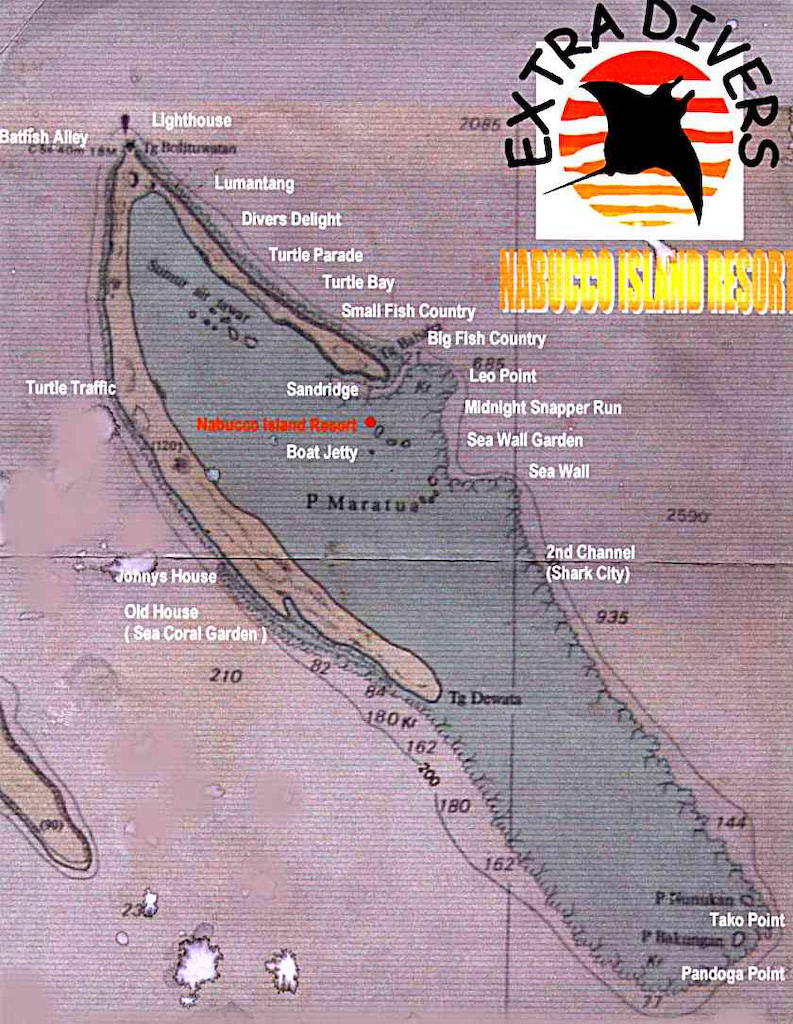
Date unknown. Active; focal plane 55 m (180 ft); white flash every 15 s. Approx. 45 m (148 ft) square skeletal tower with lantern and gallery, painted white; lantern painted red. Several blue-roofed coast guard stations. Ervan Muliyadi has a closeup photo (also seen at right), Helen Agustine has a distant view from the sea (second photo on the page), another distant view is available, and Google has a satellite view of the station. Located at the northern tip of Pulau Maratua, a large reef complex in the Celebes Sea about 50 km (30 mi) east of Tanjung Batu. Accessible only by boat. Maratua is a popular scuba diving location; a diving map shows the location of the lighthouse. Site open, tower closed. Admiralty F2015; NGA 24774. Pulau Bakungan
Date unknown. Active; focal plane 35 m (115 ft); white flash every 10 s. 30 m (98 ft) octagonal white concrete tower. 1-story keeper's house. Sayf al Hakam has a photo, another photo, a view from the sea and a small photo are available, Franz Till has a street view, and Bing has a satellite view of the station. The Virgin Cocoa resort is adjacent to the lighthouse. Located at the southeastern tip of the Maratua reef complex. Accessible only by boat. Site open, tower closed. ARLHS IDO-103; Admiralty F2019; NGA 24775.5. Sangalakki
Date unknown. Active; focal plane 15 m (49 ft); white flash every 3 s. 15 m (49 ft) square white skeletal tower mounted on a square platform supported by piles. No photo available and the tower has not been found in Bing's satellite view. Located on a shoal about 50 km (30 mi) west of Pulau Bakungan. Accessible only by boat. Site open, tower closed. Admiralty F2016; NGA 24776. Karang Tidung
Date unknown. Active; focal plane 14 m (46 ft); two white flashes every 10 s. 14 m (46 ft) tower (form unknown) mounted on a square platform supported by piles. Tower painted black with one red horizontal band. No photo available and the tower has not been found in Bing's satellite view. Located on an isolated shoal midway between the mainland and the Derawan reef complex. Accessible only by boat. Site open, tower closed. Admiralty F2016.5; NGA 24775.1. 
Tanjung Bolituwatan Light, Pulau Maratua, May 2017
Google Maps photo by Ervan Muliyadi
Karang Malalungan
Date unknown. Active; focal plane about 30 m (98 ft); white flash every 10 s. Approx. 30 m (98 ft) square pyramidal skeletal tower, painted white, mounted on a square platform supported by piles. No photo currently available but Bing has a distant satellite view. NGA lists a much smaller tower. Located on a reef about 65 km (40 mi) southwest of Pulau Maratua. Accessible only by boat. Site open, tower closed. Admiralty F2018; NGA 24780.
Pulau Sambit (Karang Muaras, Muaras Reef) (2)
Date unknown (station established 1911). Active; focal plane 43 m (141 ft); white flash every 5 s. Approx. 40 m (131 ft) square skeletal tower with lantern and gallery. Two 1-story coast guard buildings. Tower painted white, lantern and gallery red. Christian Redinger's photo is at right and Google has a satellite view. Pulau Sambit is a small island in the Celebes Sea about 80 km (50 mi) northeast of Sepinang; it occupies the extreme southeastern corner of the Muaras Reef atoll. The light guides ships approaching the Makassar Strait on the east side of Borneo. Accessible only by boat. Site open, tower closed. ARLHS IDO-032; Admiralty F2022; NGA 24784. Pulau Bilangbilangan (Bilang Bilangan)
Date unknown. Active; focal plane 13 m (43 ft); white flash every 10 s. 13 m (43 ft) "white beacon," apparently a post with gallery, mounted on a square platform supported by piles. No photo available but Google has a distant satellite view. Located at the end of a long reef extending from the mainland west of Pulau Sambit. Accessible only by boat. Site open, tower closed. Admiralty F2022.3; NGA 24787.
Kutai Timur (East Kutai) Regency Lighthouses Tanjung Mangkalihat
Date unknown (station established 1910). Active; focal plane 42 m (138 ft); white flash every 5 s. 33 m (108 ft) square pyramidal iron skeletal tower, painted white. No photo available but Google has a satellite view of the station. This may be the original lighthouse. The lighthouse stands on the easternmost point of Borneo and marks the northern entrance to the Makassar Strait from the Celebes Sea. Site status unknown. ARLHS IDO-043; Admiralty F2024.5; NGA 24788. 
Pulau Sambit Light, Celebes Sea, 2007
ex-Panoramio photo copyright Christian Redinger; used by permission
Tanjung Birahbirahan
Date unknown. Active; focal plane 14 m (46 ft); two white flashes every 10 s. 14 m (46 ft) tower mounted on a square platform. Lighthouse painted black with one red horizontal band. No photo available; Bing has a satellite view that probably shows the lighthouse. Located on a reef off the east end of an island about 100 km (60 mi) west southwest of Tanjung Mangkalihat. Accessible only by boat. Site open, tower closed. Admiralty F2024.6; NGA 24790. Pulau Miang Besar
Date unknown. Active; focal plane 51 m (167 ft); white flash every 6 s. Approx. 25 m (82 ft) square skeletal tower with gallery, painted white. Four coast guard buildings. No photo available but Bing has a good satellite view. Located on an island off the entrance to the harbor of Sangkulirang. Accessible only by boat. Site status unknown. ARLHS IDO-223; Admiralty F2024.65; NGA 24792.5. Sangatta
Date unknown. Active; focal plane 131 m (430 ft); white light, 1.5 s on. 3.5 s off. NGA describes a "white structure." This light is almost certainly on a communications tower seen in Bing's satellite view. No photo available. Sangatta is an important coal mining area. Located on heights above the port. Site status unknown. Admiralty F2024.75; NGA 24794. Sangatta (Sengata) Reef
Date unknown. Active; focal plane 25 m (82 ft); two white flashes every 8 s. 25 m (82 ft) "metal structure," according to NGA. No photo available; Bing's indistinct satellite view shows the foundation of the tower and Google has a very distant satellite view. Located on a reef about 20 km (13 mi) southeast of the Sangatta wharf. Accessible only by boat. Site open, tower closed. Admiralty F2024.805; NGA 24796.
Bontang City Lighthouses Note: Bontang is an industrial city of about 175,000 residents. Its busy port exports coal, natural gas, and fertilizer. The approaches to the various port facilities pass through a maze of marshy islands, requiring a large number of range lights. Karang Kiampan
Date unknown. Active; focal plane 10 m (33 ft); green flash every 2 s. 10 m (33 ft) square pyramidal skeletal tower with a daymark colored green. No photo available but Google has a satellite view. Located at the west point of a reef on the north side of the entrance to the northern harbor of the city. Accessible only by boat. Site status unknown. Admiralty F2025.7; NGA 24797.8. Karang Kiampan South
Date unknown. Active; focal plane 10 m (33 ft); red flash every 3 s. 10 m (33 ft) square pyramidal skeletal tower with a daymark colored red. No photo available but Google has a satellite view. Located at the west point of a reef on the south side of the entrance to the northern harbor of the city. Accessible only by boat. Site status unknown. Admiralty F2025.8; NGA 24798. Pelabuhan Loktuan Segaja Range Rear (C2)
Date unknown. Active; focal plane 20 m (66 ft); white light, 2 s on, 2 s off. 20 m (66 ft) square pyramidal skeletal tower with a daymark colored with red and white horizontal bands. No photo available but Google has a satellite view. Google also has a satellite view of the front light, on a similar tower 12 m (39 ft) tall. Located on a platform in a marsh about 5 km (3 mi) northeast of the harbor.. Site status unknown. Admiralty F2025.61; NGA 24797.5. Pelabuhan Loktuan Entrance Range Rear (A2)
Date unknown. Active; focal plane 20 m (66 ft); white light, 2 s on, 2 s off. 20 m (66 ft) square pyramidal skeletal tower with a daymark colored with red and white horizontal bands. No photo available but Google has a satellite view. Google also has a satellite view of the front light, on a similar tower 12 m (39 ft) tall. Located on a platform in a marsh about 2.5 km (1.5 mi) northeast of the harbor. Site status unknown. Admiralty F2025.1; NGA 24796.7. Pelabuhan Loktuan Batutanbu Range Rear (B2)
Date unknown. Active; focal plane 20 m (66 ft); white light, 2 s on, 2 s off. 20 m (66 ft) square pyramidal skeletal tower with a daymark colored with red and white horizontal bands. No photo available but Google has a satellite view. This range guides vessels departing the port. Google also has a satellite view of the front light, on a similar tower 12 m (39 ft) tall. Located on a platform in a marsh 320 m (350 yd) south southeast of the front light. Site status unknown. Admiralty F2025.41; NGA 24797.1. Bontang Fifth Range Rear (OG)
Date unknown. Active; focal plane 23 m (75 ft); white light, 3 s on, 3 s off. 23 m (75 ft) square skeletal tower painted white and mounted on a square platform supported by piles. No photo available but Google has a satellite view. Google also has a satellite view of the front light, on a similar tower 16 m (52 ft) tall). Located south of the Bontang natural gas harbor. Accessible only by boat. Site open, tower closed. Admiralty F2031.1; NGA 24819.1.
Bontang Fourth Range Rear (OD)
Date unknown. Active; focal plane 30 m (98 ft); quick-flashing white light. 25 m (82 ft) square skeletal tower painted white and mounted on a square platform supported by piles. No photo available but Google has a satellite view. Google also has a satellite view of the front light, on a similar tower 16 m (52 ft) tall). Located in the Bontang natural gas harbor. Accessible only by boat. Site open, tower closed. Admiralty F2029.41; NGA 24818.1. Bontang Third Range Rear (3B)
Date unknown. Active; focal plane 23 m (75 ft); quick-flashing white light. 23 m (75 ft) square skeletal tower painted white. No photo available but Google has a satellite view. Google also has a satellite view of the front light, on a similar tower 16 m (52 ft) tall); it also carries the front light of the outbound range (next entry). Located in Bontang harbor about 1.2 km (3/4 mi) southeast of the waterfront. Accessible only by boat. Site open, tower closed. Admiralty F2028.9; NGA 24817.4. Bontang Outbound Range Rear (OC2)
Date unknown. Active; focal plane 23 m (75 ft); white light, 3 s on, 3 s off. 23 m (75 ft) square skeletal tower painted white. No photo available but Google has a satellite view. Located in Bontang harbor about 600 m (3/8 mi) east of the Third Range Rear light. Accessible only by boat. Site open, tower closed. Admiralty F2029.1; NGA 24817.2. Bontang Second Range Rear (2B)
Date unknown. Active; focal plane 23 m (75 ft); quick-flashing white light. 23 m (75 ft) square skeletal tower painted white. No photo available but Google has a satellite view. Google also has a satellite view of the front light, on a similar tower 16 m (52 ft) tall). Located about 5 km (3 mi) southeast of the natural gas harbor. Accessible only by boat. Site open, tower closed. Admiralty F2028.31; NGA 24816. * Pulau Beras Basah
Date unknown. Active; focal plane 36 m (118 ft); five white flashes, in a 3+2 pattern, every 20.5 s. 35 m (115 ft) square pyramidal skeletal tower with gallery, enclosed with metal plates. A photo is at right, Wikimedia has a more distant view, a 2014 photo is available, and Google has a satellite view. As of 2009 the tower was in poor condition, and some of the plates had fallen off. Apparently the lighthouse was repaired and restored in 2011. Beras Basah is a popular resort island almost precisely on the Equator, about 8 km (5 mi) southeast of the port of Bontang. Located on the beach. Site open, tower closed. Admiralty F2027; NGA 24808. 
Pulau Beras Basah Light, Makassar Strait, September 2012
photo copyright kedaihijau; permission requested
Bontang Entrance Range Rear (1B)
Date unknown. Active; focal plane 23 m (75 ft); quick-flashing white light. 23 m (75 ft) square skeletal tower painted white. No photo available, but Google has a satellite view. Google also has a satellite view of the front light, on a similar tower 16 m (52 ft) tall). Located about 2 km (1.2 mi) west of Pulau Beras Basah. Accessible only by boat. Site open, tower closed. Admiralty F2028.1; NGA 24804.
Tanjung Meranggas Range Rear
Date unknown. Active; focal plane 18 m (59 ft); white light, 2 s on, 2 s off. 18 m (59 ft) square skeletal tower painted white. No photo available, but Google has a satellite view. The front light is on a short skeletal tower. Google also has a satellite view of the front light, on a similar tower 7 m (23 ft) tall).Located on a marshy point across from the Bontang Coal terminal. Accessible only by boat. Site open, tower closed. Admiralty F2028.21; NGA 24810.1.
Kutai Kartanegara Regency Lighthouses Tanjung Tamarong
2007. Active; focal plane 33 m (180 ft); white light, 2 s on, 8 s off. 30 m (98 ft) "white tower." No photo available, and the tower is not seen in Bing's satellite view. Tanjung Tamarong is the easternmost point of the Mahakam river delta. Located (apparently) about 2.5 km (1.5 mi) east of the cape, in which case it is accessible only by boat. Site open, tower closed. Admiralty Q1468.46; NGA 24881. Tanjung Kayumajarang
Date unknown. Active; focal plane 19 m (62 ft); three white flashes evry 15 s. This light is on a tall communications tower mounted on an offshore loading port just off the Mahakam river delta. No photo available but Bing has a satellite view. Accessible only by boat. Site status unknown. Admiralty Q1468.25; NGA 24859. Bukuan (Muara Pegah, Pulau Bukuan, Bukuan Island, Samarinda)
Date unknown. Active; focal plane 41 m (135 ft); white flash every 15 s. Approx. 40 m (131 ft) skeletal tower with lantern and gallery, painted white. A 2016 photo (also seen at right) is available and Google has a satellite view. Located on an island at the south end of the delta of the Mahakam River, which leads to Samarinda, the capital of East Kalimantan. Site status unknown. ARLHS IDO-119; Admiralty Q1462; NGA 24846. 
Pulau Bukuan Light, Samarinda, February 2016
Google Plus photo by VTS Samarinda
Balikpapan City Lighthouses Note: Balikpapan is a large city, having more than 700,000 residents; it is the center for oil production in eastern Kalimantan. It was captured by the Japanese early in World War II and retaken by Allied troops in very heavy fighting in July 1945, one of the last battles of the war.
* Tanjung Manggar
Date unknown. Active; focal plane 43 m (141 ft); three white flashes every 21 s. 40 m (131 ft) square skeletal tower with lantern and gallery; tower painted white, lantern red. Jaya Frana has a 2018 photo and Google has a street view and a satellite view of the station. Located at a regional office of the sea navigation directorate, on a minor cape about 20 km (13 mi) northeast of Balikpapan. Site open, tower closed. ARLHS IDO-313; Admiralty Q1459.8; NGA 24918. Balikpapan (Tanjung Tokong, Tukong Hill) (3?)
Date unknown. Active; focal plane 93 m (305 ft); one long white flash every 20 s. 30 m (98 ft) square skeletal tower with gallery, painted with red and white horizontal bands. Irma Widyasta Pratiwi's photo is at right, another photo is available, and Google has a satellite view. Forand has a historic postcard view said to be of an earlier lighthouse, but light lists do not describe such a tower. In fact, no references are known to any Balikpapan lighthouse prior to World War II. NGA describes an 8 m (26 ft) "white building," a light known to have been in place at least by 1955. Located atop a steep hill on the east side of the entrance to Balikpapan's harbor. Site status unknown. ARLHS IDO-362; Admiralty Q1459; NGA 24920.
Penajam Paser Utara (North Penajam Pasar) Regency Lighthouses Balikpapan Approach Common Range Rear
Date unknown. Active; focal plane 25 m (82 ft); white light, 1 s on, 1 s off. 25 m (82 ft) square skeletal tower painted white. No photo available and the tower does not appear in Bing's satellite view. Located about 5 km (3 mi) off Panajam in the northwestern corner of Balikpapan Bay. Accessible only by boat. Admiralty Q1459.41; NGA 24904. Tanjung Maruat
Date unknown. Active; focal plane 16 m (52 ft); white flash every 10 s. 16 m (52 ft) tower on a square platform. No photo available, and the lighthouse is barely visible in Bing's satellite view of the area. Located on a shoal off a cape about 80 km (50 mi) southwest of Balikpapan. Accessible only by boat. Site status unknown. Admiralty Q1458; NGA 24923.7. 
Tanjung Tokong Light, Balikpapan, 2011
photo copyright Irma Widyasta Pratiwi; used by permission
Pasar Regency Lighthouse Gosong Aru (Aru Bank)
Date unknown (station established 1901). Active; focal plane 13 m (43 ft); three quick white flashes every 10 s. 13 m (43 ft) skeletal tower mounted on a platform supported by piles. No photo available. This is the oldest offshore light station in the Makassar Strait. Located on a notorious shoal about 130 km (80 mi) south of Balikpapan. Accessible only by boat. Site open, tower closed. ARLHS IDO-364; Admiralty Q1454; NGA 24932.
Information available on lost lighthouses:
Notable faux lighthouses:
Lighthouses of Indonesia: Southern Kalimantan (Borneo)
Indonesia has been independent since 1945, after having been the Dutch East Indies for more than 350 years. It is a huge country, stretching along both sides of the Equator for more than 46 degrees of longitude (roughly 5100 km or 3200 miles). Comprised of some 17,000 islands (more than 6000 inhabited islands), it has hundreds of major aids to navigation. Unfortunately, we have no idea how many of these aids can be considered lighthouses. Information about them is scarce, and photos are even scarcer. Official light lists contain dozens of entries for "framework towers" and "white beacons," providing little guidance for the lighthouse fan.
Borneo, known as Kalimantan in Indonesia, is the world's third largest island. 73% of the island is Indonesian; the remaining portion includes the Malaysian states of Sarawak and Sabah and the independent sultanate of Brunei. This page describes lighthouses of southern Kalimantan including the provinces of South Kalimantan, Central Kalimantan, and West Kalimantan.
The Indonesian word for a lighthouse is mercusuar. The phrase menara suar, which includes the Arabic word menara, is sometimes used instead. Tanjung and ujung are words for capes, pulau is an island, selat is a strait, karang is a reef, gosong is a shoal or sandbar, and teluk is a harbor.
Aids to navigation in Indonesia are operated and maintained by the Directorate General of Sea Navigation.
ARLHS numbers are from the ARLHS World List of Lights. Admiralty numbers are from volumes F and Q of the Admiralty List of Lights & Fog Signals. U.S. NGA List numbers are from Publication 112. 
Gunung Belingkar Light, Kotabaru, February 2014
photo copyright Harmiyono Utomo; permission requested
General Sources Online List of Lights - Indonesia - Vol. F and Vol. Q
Coming soon: photos by various photographers posted by Alexander Trabas. Indonesian Lighthouses
Historic postcard views from the collection of Michel Forand. World of Lighthouses - Indonesia
Photos by various photographers available from Lightphotos.net. GPSNauticalCharts
Navigational chart information for West Kalimantan.
Kalimantan Selatan (South Kalimantan) Province Lighthouses Note: South Kalimantan Province occupies the southeastern corner of Borneo with coasts facing east on the Makassar Strait and south on the Java Sea.
Kotabaru Regency Lighthouses Note: Kotabaru is a city of about 250,000 residents. It is located on Pulau Laut ("Sea Island"), an island about 55 km (35 mi) long that lies just off the southeastern tip of Kalimantan. The northern half of the island is separated from the mainland by a narrow strait (Selat Laut, "Sea Strait"). The city is near the northern end of the island facing west on the strait. Pulau Larilarian (Lari Larian)
2007(?). Active; focal plane 32 m (105 ft); white flash every 5 s. 30 m (98 ft) skeletal tower, painted white. No photo available but Bing has an indistinct satellite view. This island was claimed by South Kalimantan and East Sulawesi provinces; a 2011 ruling by the Indonesian Supreme Court confirmed South Kalimantan's jurisdiction. Located on an isolated island in Makassar Strait about 145 km (90 mi) due east of Pulau Laut. Accessible only by boat. Site status unknown. ARLHS IDO-212; Admiralty Q1445; NGA 24947.
Tanjung Pemancingan Range Front
Date unknown. Active; focal plane 14 m (46 ft); white flash every 5 s. 12 m (39 ft) square skeletal tower painted white and carrying a triangular daymark, point up. No photo available but Google has a satellite view. Located on the east side near the northeastern tip of Pulau Laut. Site status unknown. Admiralty Q1438; NGA 24952. * Gunung Belingkar (Balingkar Hill, Tanjung Pemancingan Range Rear, Kotabaru)
1901. Active; focal plane 67 m (220 ft); white flash every 5 s. 20 m (66 ft) hexagonal pyramidal skeletal tower with lantern and gallery. Entire lighthouse painted white. A photo is at the top of this page, Wijaya Yoga has a 2018 photo, Sugeng Hidayat has another photo, and Google has a satellite view. It seems likely that this is the original Dutch lighthouse, but we need information on its history. Located on a ridge in Kotabaru, near the northern tip of Pulau Laut. Site status unknown, but the lighthouse must be easy to see from nearby. ARLHS IDO-105; Admiralty Q1438.1; NGA 24956. Sambergelap (Samber Gelap, Pulau Buton Butona)
Date unknown. Active; focal plane 21 m (69 ft) (?); three white flashes every 15 s. 14 m (46 ft) (?) square skeletal tower with lantern and gallery, painted white. Aries Yulianto has a 2018 photo (also seen at right) and Bing has a satellite view. The lighthouse appears taller than the listed height. The Sambergelap Islands are a small group of islands located about 30 km (19 mi) east of Pulau Laut. The lighthouse is on the westernmost island, which also has a turtle conservation station. Ecotours to the island are available. Accessible only by boat. Admiralty Q1444; NGA 24948. 
Sambergelap Light, Kotabaru, March 2018
Google Plus photo by Aries Yulianto
Pulau Aur
Date unknown. Active; focal plane 27 m (89 ft); white flash every 4 s. Approx. 18 m (59 ft) square skeletal tower painted white. No photo available but Google has a satellite view. Pulau Aur is a small, uninhabited island off the southeast coast of Pulau Laut and south of the much larger island of Pulau Sebuku. Located near the southern tip of the island. Accessible only by boat. Site status unknown. Admiralty Q1444.2; NGA 24987.5. Tanjung Kunyit (Pulau Kunit)
Date unknown (early 1900s). Active; focal plane 135 m (443 ft); white flash every 5 s. 13 m (43 ft) hexagonal pyramidal skeletal tower with lantern and gallery, painted white. Two 1-story station buildings. Cah Kediri has a 2019 photo (also seen at right), Dennis Yapari has a photo, another photo (3/4 the way down the page) is available and Google has a satellite view of the station. Located on the heights of Pulau Kunyit, an island just off the southern tip of Pulau Laut. Accessible only by boat. Site open, tower closed. Admiralty Q1430; NGA 24968. Tanjung Pangebalan
Date unknown. Active; focal plane 18 m (59 ft); white flashes every 5 s. Approx. 15 m (49 ft) round white concrete or fiberglass tower. No photo available but Google has a fuzzy satellite view. Located at the foot of a headland on the southwestern coast of Pulau Laut. Site status unknown. Admiralty Q1431; NGA 24966. Suwangi
Date unknown. Active; focal plane 28 m (92 ft); white flash every 3.5 s. Approx. 18 m (59 ft) square skeletal tower painted white. No photo available but Bing has a satellite view. Suwangi is a forested, uninhabited island in the Laut Strait off Batulicin. Located near the south end of the island. Accessible only by boat. Site status unknown. Admiralty Q1434; NGA 24972.
Kotabaru Regency: Java Sea Islands Lighthouses Note: These islands form a ragged chain extending southwest into the Java Sea from Pulau Laut. They are known collectively as the Kepulauan Laut Kecil, "Small Sea Islands." Pulau Birabirahan (Birah Birahan)
Date unknown. Active; focal plane 12 m (39 ft); white flash every 6 s. 12 m (39 ft) round white fiberglass tower with a flared top mounted on a platform supported by piles. A photo is available and Bing has a satellite view. Located just off the northern tip of an island about 15 km (9 mi) south of the southern tip of Pulau Laut. Accessible only by boat. Site status unknown. Admiralty Q1442.1; NGA 24970. 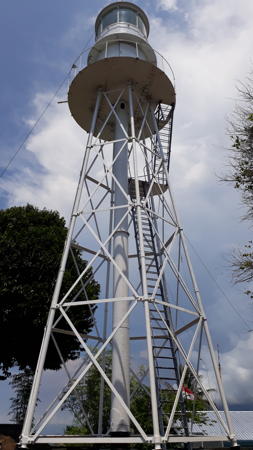
Pulau Kunyit Light, Kotabaru, January 2019
Google Plus photo by Cah Kediri
Pulau Payong Payongan (Payung Payungan)
Date unknown. Active; focal plane 32 m (105 ft) (?); white flash every 6 s. 10 m (33 ft) square skeletal tower painted white. No photo available but Bing has a satellite view. Located on the southernmost of a group of small islands about 30 km (19 mi) southwest of the southern tip of Pulau Laut. Accessible only by boat. Site status unknown. Admiralty Q1427.4; NGA 24974. Sambargalang (Samber Galang, Brothers Islands)
Date unknown. Active; focal plane 55 m (180 ft); white flash every 5 s. 20 m (66 ft) tapered square skeletal tower with gallery, painted white. Four 1-story coast guard buildings. No photo available but Bing has a satellite view of the station. Located on an island in the southwestern entrance to the Makassar Strait, about 175 km (110 mi) east of Tanjung Selatan and about 40 km (25 mi) south of the southeastern corner of Borneo at Pulau Laut. Accessible only by boat. Site status unknown. ARLHS IDO-017; Admiralty Q1442; NGA 24976.
Pulau Kalambau (Kelambau)
Date unknown. Active; focal plane 15 m (49 ft); white flash every 5 s. Described only as a "white beacon," most likely a square white skeletal tower. No photo available but Bing has a distant satellite view. NGA misspells the location as Kelambu. Located at the southwestern tip of Pulau Kalambau, the outermost of the Laut Kecil islands. Site status unknown. Admiralty Q1426.5; NGA 24978.
Tanah Bumbu Regency Lighthouses * Batulicin
Date unknown. Active; focal plane 22 m (72 ft); white flash every 6 s. 20 m (66 ft) square skeletal tower with gallery, painted white. Apriadi Utama has a photo (tower on the left, behind the tree) and Google has an indistinct satellite view. Batulicin, on the west side of the Laut Strait opposite Kotabaru, is an important ferry port. Located at the base of the ferry pier in Batulicin. Site open, tower closed. Admiralty Q1435; NGA 24973. Tanjung Petang
1901. Active; focal plane 19 m (62 ft); white flash every 5 s. 19 m (62 ft) hexagonal cast iron skeletal tower with lantern and gallery, painted white. Several 1-story coast guard buildings. Inni Joa's photo is at right, Mocha Putri has a 2015 photo, and Google has a satellite view of the station. This light is a twin of the Belingkar Hill lighthouse. Located near Pagatan, on the west side of the southern entrance to the narrow Laut Strait separating Pulau Laut from the mainland of Borneo. Site status unknown. ARLHS IDO-289; Admiralty Q1432; NGA 24964. 
Tanjung Petang Light, Tanah Bumbu, November 2017
Google Plus photo by Inni Joa
Tanah Laut Regency Lighthouses Muara Kintap (Kintap Estuary) Range Rear
Date unknown. Active; focal plane about 20 m (66 ft); light characteristic unknown. Approx. 12 m (39 ft) square white skeletal tower. No photo available but Google has a satellite view. The front light is on a shorter skeletal tower. Located at the entrance to the Kintap estuary about 65 km (40 mi) northeast of South Cape. Site status unknown. Admiralty Q1423.1.
Tanjung Selatan (South Cape)
Date unknown (station established 1905). Active; focal plane 34 m (112 ft); one long white flash every 6 s. 30 m (98 ft) hexagonal cast iron tower with lantern and gallery. Several 1-story coast guard buildings. Lighthouse painted white. Done Husen's closeup photo is at right and Google has a satellite view of the station. Tanjung Selatan (South Cape) is the southernmost point of Borneo. Located on the point of the cape, about 80 km (50 mi) south of Banjarmasin. Site status unknown. ARLHS IDO-328; Admiralty Q1422; NGA 24988. Tekisung (Batu Layang Layang)
Date unknown. Active; focal plane 19 m (62 ft); yellow flash every 3 s. 19 m (62 ft) beacon, painted yellow. No photo available and Google has only an indistinct satellite view. Located off the Tekisung beach about 50 km (30 mi) north of Tanjung Selatan. Accessible only by boat but probably visible from shore. Site open, tower closed. Admiralty Q1420; NGA 24989. Sungai Barito Outer
Date unknown (lightship station established 1901). Inactive since 2013. Approx. 20 m (66 ft) square skeletal tower adjacent to a building (possibly a pilot station) mounted on a pier supported by piles. Ar Lani has a 2017 photo but the tower is not seen in Google's distant satellite view of the area. The lighthouse was replaced by a buoy (NGA 24992). Located about 18 km (11 mi) southwest of the mouth of the Barito River. Accessible only by boat. Site open, tower closed. ex-Admiralty K1413.1; ex-NGA 24996.
Banjar Regency Lighthouses Sungai Barito Range Front
Date unknown. Active; focal plane 25 m (82 ft); white light, 1 s on, 1 s off. 25 m (82 ft) square skeletal tower painted with black and white horizontal bands and mounted on a platform supported by piles. No photo available but Bing has a satellite view. This is the entrance range for the Barito River, which leads to the provincial capital Banjarmasin. Located south of the mouth of the river. Accessible only by boat. Site open, tower closed. Admiralty Q1413.7; NGA 25000. Sungai Barito Range Rear
Date unknown. Active; focal plane 40 m (131 ft); white light, 2 s on, 2 s off. 40 m (131 ft) square skeletal tower painted with black and white horizontal bands and mounted on a platform supported by piles. No photo available but Bing has a satellite view. Located in the mouth of the Barito River 1.7 km (1 mi) north northeast of the front light. Accessible only by boat. Site open, tower closed. Admiralty Q1413.71; NGA 25004. 
Tanjung Selatan Light, Tanah Laut, 2010
Panoramio photo copyright Done Husen; used by permission
Kalimantan Tengah (Central Kalimantan) Province Lighthouses Note: Central Kalimantan Province includes much of the south coast of Borneo, facing the Java Sea.
Pulang Pisau Regency Lighthouse Sungai Kahayan Range Rear
Date unknown. Active; focal plane 18 m (59 ft); white light, 2 s on, 3 s off. Approx. 15 m (49 ft) square skeletal tower, painted white, mounted on a square platform supported by piles. No photo available but Google has a satellite view. The front light is on a similar skeletal tower with a focal plane of 10 m (33 ft). Located on the east side of the entrance to the Kahayan River. Site status unknown. Admiralty Q1412.51; NGA 25026.1.
Kotawaringin Timur (East Kotawaringin) Regency Lighthouses
Tanjung Serambut Range Rear
Date unknown. Active; focal plane 16 m (52 ft); white flash every 4 s. 13 m (43 ft) square skeletal tower painted white, mounted on a square platform supported by piles. No photo available but Google has a satellite view. The front light is on a similar skeletal tower. Located on the east side of the entrance to the Sampit River. Site status unknown. Admiralty Q1411.85; NGA 25030.1. Tanjung Bandaran
Date unknown. Active; focal plane 15 m (49 ft); white flash every 4 s. 15 m (49 ft) skeletal tower, painted white. No photo available but Bing has a satellite view of the tower. Located at the end of a spit on the west side of the entrance to the bay of Setriruk. Site status unknown. Admiralty Q1411.6; NGA 25032. * Ujung Pandaran
2007 (?). Active; focal plane 43 m (141 ft); white flash every 5 s. 40 m (131 ft) square skeletal tower with lantern and gallery. Half a dozen coast guard buildings. Entire lighthouse painted white. Google has a distant street view and Bing has a satellite view of the station. Located near the base of the spit on the west side of the entrance to the bay of Setriruk. Site open, tower closed. Admiralty Q1411.5.
Seruyan Regency Lighthouse Tanjung Siamok
Date unknown. Active; focal plane 20 m (66 ft); two quick white flashes every 5 s. 15 m (49 ft) skeletal tower, painted white, mounted on a square platform supported by piles. Jito Djail's photo is at right and Google has a fuzzy satellite view. Located on the east side of the entrance to the Seruyan River about 25 km (15 mi) southeast of Segintong. Accessible only by boat but easily seen from shore. Site open, tower closed. Admiralty Q1411.4; NGA 25036. 
Tanjung Siamok Light, Seruyan, March 2017
Google Plus photo by Dito Djail
Kotawaringin Barat (West Kotawaringin) Regency Lighthouses
Tanjung Putung (Tanjung Puting)
Date unknown. Active; focal plane 31 m (102 ft); three white flashes every 14 s. Approx. 28 m (92 ft) tapered square skeletal tower with gallery, painted white. No photo available but Google has a satellite view of the station. Tanjung Putung is a prominent cape about 55 km (35 mi) southwest of Segintong. Site status unknown. Admiralty Q1411.2; NGA 25040. * Pelabuhan Kumai (Kumai Port)
Date unknown. Active; focal plane about 24 m (79 ft); light characteristic unknown. Approx. 20 m (66 ft) square skeletal tower with gallery, painted white. Clasic Dyddunia has a photo (also seen at right), and Bing has a satellite view. Located on the waterfront at Kumai, a port on the Kumai River. Site open, tower closed. Admiralty Q1411.36. Tanjung Kluang
Date unknown. Active; focal plane 12 m (39 ft); white flash every 5 s. 12 m (39 ft) skeletal tower, painted white. No photo available but Google has an indistinct satellite view. Located near the end of a long spit on the west side of the entrance to Kumai Bay. Site status unknown. Admiralty Q1411.25; NGA 25046.
Sukamara Regency Lighthouse * Pelabuhan Jelai (Jelai Port)
Date unknown. Active; focal plane about 20 m (66 ft); light characteristic unknown. Approx. 17 m (56 ft) square skeletal tower with gallery, painted white. No photo available but Google has a satellite view. Located on the waterfront at Jelai, a port on the Jelai-Bila River, which forms part of the border between Central Kalimantan and West Kalimantan. Site open, tower closed. Admiralty Q1410.63. 
Pelabuhan Kumai Light, Kumai, May 2015
Google Plus photo by Clasic Dyddunia
Kalimantan Barat (West Kalimantan) Province Lighthouses Note: West Kalimantan Province occupies the southwestern corner of Borneo with a coast that faces west, mostly on the
Ketapang Regency Lighthouses Gosong Mampango (Discovery East Bank) (2)
Date unknown (station established 1903). Active; focal plane 13 m (43 ft); white flash every 5 s. 20 m (66 ft) skeletal tower, painted with red and white horizontal bands. No photo available but Lightphotos.net has a historic photo of the original Dutch lighthouse, said to have been destroyed in World War II. (This photo is from a Java Post article.) In Jaunary 2010 the Irish racing yacht Cork Clipper wrecked near the light, bringing it briefly to international attention. Located on a dangerous reef far out in the northwestern corner of the Java Sea, about 200 km (125 mi) southwest of the southwestern corner of Kalimantan. Accessible only by boat. Site status unknown. ARLHS IDO-132; Admiralty Q1034; NGA 25052. Gosong Mangkut
Date unknown. Active; focal plane 15 m (49 ft); two white flashes every 5 s. 15 m (49 ft) tower, painted black with one red horizontal band. No photo available and the islet is barely visible in Google's distant satellite view. Located on a shoal about 16 km (10 mi) southwest of the southwestern tip of Kalimantan. Accessible only by boat. Site open, tower closed. Admiralty Q1410.3; NGA 25049.
Pulau Bawal (Tanjung Rotan)
Date unknown. Active; focal plane 67 m (220 ft); three white flashes every 12 s. 30 m (98 ft) square skeletal tower painted white. No photo available but Bing has a very distant satellite view. Pulau Bawal is an island about 10 km (6 mi) northwest of Tanjung Simbar, the southwestern corner of Borneo. Site status unknown. Admiralty Q1410; NGA 25050.
Kayong Utara (North Kayong) Regency: Karimata Islands Lighthouses Karang Ontario (Ontario Reef)
Date unknown. Active; focal plane 15 m (49 ft); two white flashes every 5 s. 15 m (49 ft) tower, painted black with one red horizontal band. No photo available. Located on a coral reef 31 km (19.5 mi) south southwest of Palau Serutu; the safe shipping channel of the Karimata Strait lies between these lights. Accessible only by boat. Site status unknown. Admiralty Q1405.5; NGA 25058. Pulau Serutu
1902. Active; focal plane 175 m (574 ft); three quick white flashes every 10 s. 25 m (82 ft) octagonal cast iron skeletal tower with lantern and gallery, painted white. A photo is at right and Google has a partially clouded satellite view of the station. This is a major light with a range of 36 nautical miles (67 km, 42 mi). There is a proposal to protect the light station as a heritage area. Pulau Serutu anchors the southwest end of the Karimata Archipelago, which extends into the Karimata Strait separating Kalimantan from Sumatra. The light is an important landmark for ships sailing between Singapore and Jakarta. Located on the highest point of the island. Site status unknown. ARLHS IDO-181; Admiralty Q1406; NGA 25060. 
Pulau Serutu Light, Karimata Strait, March 2017
Western Karimata Province Cultural Survey Team photo
Pulau Macan
Date unknown. Active; focal plane 50 m (164 ft); two white flashes every 5 s. 10 m (33 ft) square white skeletal tower. No photo available but Google has a satellite view. Located on a small island in the southeastern Karimata Archipelago.Accessible only by boat. Site status unknown. Admiralty Q1407.7; NGA 25064.4. Pulau Layah Kecil
Date unknown. Active; focal plane 72 m (236 ft); two white flashes every 15 s. 40 m (131 ft) square skeletal tower with lantern and gallery, painted white; lantern painted red. Several coast guard buildings. The Coast Guard has a small photo and Bing has a satellite view of the station. This lighthouse is in Sukadana Bay, a broad embayment on the southwest coast of Kalimantan. Located on a small island about 80 km (50 mi) west of Tanjung Baikbudi. Accessible only by boat. Site status unknown. ARLHS IDO-213; Admiralty Q1407.5; NGA 25064.1.
Pulau Lemanbudi (Lemen Boedi) (2?)
Date unknown. Active; focal plane 48 m (157 ft); two white flashes every 8 s. 15 m (49 ft) octagonal cylindrical concrete tower, painted white. The Coast Guard photo is at right and Bing has a satellite view. NGA lists a skeletal tower. Located on the outermost of a group of small islands at the north edge of the Karimata Archipelago. Accessible only by boat. Site status unknown. Admiralty Q1407; NGA 25064.
Kabu Raya Regency Lighthouses Pulau Masatiga
Date unknown. Active; focal plane about 20 m (66 ft); white light, characteristic unknown. Approx. 15 m (49 ft) square white skeletal tower. No photo available but Bing has a satellite view. Located on a small island off the southwestern tip of Pulau Padangtikar. Accessible only by boat. Site status unknown. Admiralty Q1403.5. Tanjung Padangtikar (Padang Tikar)
Date unknown. Active; focal plane 15 m (49 ft); white flash every 3 s. 15 m (49 ft) round white fiberglass tower mounted on a platform supported by piles. No photo available but Bing has an indistinct satellite view. The range guides vessels into the Bangkolan River estuary leading to the port of Batu Ampar. Located on the south side of the river mouth and just off the northwestern tip of Pulau Padangtikar. Accessible only by boat. Site open, tower closed. Admiralty Q1402; NGA 25068.
Pontianak Regency Lighthouses Sungai Kapuas Kecil (Pontianak) Range Front
Date unknown. Active; focal plane 16 m (52 ft); quick-flashing white light. 15 m (49 ft) square skeletal tower mounted on a platform supported by piles. No photo available but Bing has an indistinct satellite view. The range guides vessels into the Little Kapuas River estuary leading to Pontianak, the capital of West Kalimantan. The rear light is on a smaller tower on a hillside onshore. Located on the north side of the river mouth. Accessible only by boat. Site open, tower closed. Admiralty F1872; NGA 25072. 
Pulau Lemanbudi Light, Karimata Strait
Indonesian Coast Guard Pontianak Navigation Region photo
Pulau Datu (Dato)
Date unknown. Active; focal plane 62 m (203 ft); three white flashes every 9 s. 30 m (98 ft) white skeletal tower. No photo available but Google has an indistinct satellite view. Located on an uninhabited island about 65 km (40 mi) west northwest of the Kapuas River mouth. Accessible only by boat. Site status unknown. Admiralty F1879; NGA 25081. Pulau Pengiki
Date unknown. Active; focal plane 206 m (676 ft); three white flashes every 20 s. 15 m (49 ft) white 16-sided skeletal tower. The Coast Guard has a small photo and Bing has a distant satellite view. Located on an island about 65 km (40 mi) west northwest of Pulau Datu. Accessible only by boat. Site status unknown. Admiralty F1880; NGA 25080. Pulau Sitinjan (Sitijan) (2?)
Date unknown. Active; focal plane 90 m (295 ft); two white flashes every 15 s. The Coast Guard has a small photo and Google has a satellite view. Approx. 30 m (98 ft) square white skeletal tower with lantern and gallery. NGA lists a concrete tower. Located on an island about 75 km (45 mi) northwest of the Kapuas River mouth. Accessible only by boat. Site status unknown. Admiralty F1883; NGA 25082. Pulau Lemukutan (Lemoekoetan)
Date unknown. Active; focal plane 314 m (1030 ft); three white flashes every 10 s. 19 m (59 ft) skeletal tower, painted white. No photo available and the tower has not been found in Google's satellite view. Pulau Lemukutan is a mountainous island about 18 km (12 mi) off the westernmost point of Kalimantan. Located on the highest point of the island. Accessible only by boat. Site status unknown. ARLHS IDO-214; Admiralty F1885; NGA 25084.
Sambas Regency Lighthouses Tanjung Batu (Pemangkat)
Date unknown. Active; focal plane 11 m (36 ft); green flash every 3 s. 11 m (36 ft) tower. No photo available and the tower is hard to distinguish in Google's satellite view. Located at the tip of a promontory on the south side of the entrance to the Sambas River. Site status unknown. Admiralty F1890; NGA 25088.
Sungai Sambas Besar Range (Pemangkat Range) Front
Date unknown. Active; focal plane 15 m (49 ft); white light, 1 s on, 1 s off. 15 m (49 ft) square skeletal tower mounted on a platform supported by piles. Tower painted with black and white horizontal bands. No photo available but Google has a satellite view. This is the entrance range for the Sambas River. Located in the river about 800 m (1/2 mi) northeast of Tanjung Batu. Accessible only by boat. Site open, tower closed. Admiralty F1892; NGA 25094. Sungai Sambas Besar Range (Pemangkat Range) Rear
Date unknown. Active; focal plane 20 m (66 ft); white light, 2 s on, 2 s off. 20 m (66 ft) square skeletal tower mounted on a platform supported by piles. Tower painted with black and white horizontal bands. No photo available but Google has a satellite view. Located just off the south bank of the river 1148 m (0.71 mi) east of the front light. Accessible only by boat. Site open, tower closed. Admiralty F1892.1; NGA 25094.2. Bukit Kalangbau (Kalang Bahu, Sungai Sambas)
Date unknown. Active; focal plane 132 m (433 ft); two white flashes every 15 s. 40 m (131 ft) tapered square skeletal tower with lantern and gallery, painted white. Bung Jang has a 2018 closeup photo, Yanto Wen also has a closeup, the Coast Guard has a small photo and Google has a satellite view of the station. NGA lists the station as Pulau Pekak, although it is not on an island. Located on a steep-sided hill on the north side of the entrance to the Sambas River opposite the port of Pemangkat. Site status unknown. Admiralty F1891; NGA 25092. Tanjung Datu (2)
2004 (station established 1988). Active; focal plane about 200 m (656 ft); two long (1.5 s) white flashes every 12 s. 40 m (131 ft) square skeletal tower with gallery, painted white, centered on a 2-story station building. Yus Ran's photo is at right, the Coast Guard has several photos, and Google has a satellite view of the station. This staffed lighthouse marks the border between Indonesia and the Sarawak state of Malaysia. At least since 1988 this border has been the site of dueling lighthouses, one on the Malaysian side and one on the Indonesian side. A photo posted by Greenfinder.asia shows the Malaysian 8 m (26 ft) round cylindrical concrete tower (focal plane 171 m (561 ft; white flash every 15 s) as well as the original Indonesian light. A chain link fence separates the Indonesian light station from the Malaysian light. In 2014 Malaysia began construction of a new light on a platform off the point of the cape; construction was halted when Indonesia protested that the location was in Indonesian waters as provided by a 1969 treaty. Located on a promontory at the tip of the Datu Peninsula about 50 km (30 mi) northwest of Sematan, Malaysia. Site status unknown. Admiralty F1893.2. 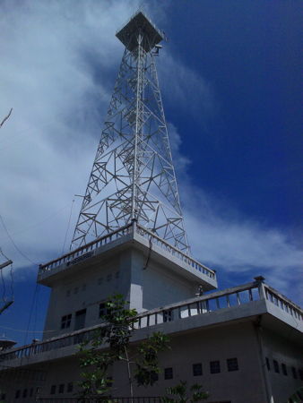
Tanjung Datu Light, Sambas, October 2016
Google Plus photo copyright Yus Ran
Information available on lost lighthouses:
Notable faux lighthouses:
.
Tuesday, January 28, 2020
LightHouse Borneo and surroundings
Subscribe to:
Post Comments (Atom)
No comments:
Post a Comment