
Lighthouses of Indonesia: Eastern Aceh, Sumatra
Indonesia has been independent since 1945 after having been the Dutch East Indies for more than 350 years. It is a huge country, stretching along both sides of the Equator for more than 46 degrees of longitude (roughly 5100 km or 3200 miles). Comprised of some 17,000 islands (more than 6000 inhabited islands), it has hundreds of major aids to navigation. Unfortunately, it's difficult to know how many of these aids can be considered lighthouses. Information about them is scarce and photos are even scarcer. Official light lists contain dozens of entries for "framework towers" and "white beacons," providing little guidance for the lighthouse fan.
Sumatra (or, as Indonesians prefer, Sumatera) is the world's sixth largest island and the westernmost of the major islands of Indonesia. It is separated from Malaysia to the north by the Malacca Strait, from Borneo to the northeast by the broad Karimata Strait, and from Java to the southeast by the Sunda Strait. Its south coast faces the open Indian Ocean.
Located at the northwestern end of Sumatra, Aceh was the scene of a lengthy and sometimes violent separatist movement, first against Dutch control and then against Indonesian administration. Following the disastrous tsunami of 26 December 2004 a peace agreement, negotiated with the help of Finnish diplomats, was signed in August 2005. Aceh is governed not as a province of Indonesia but as a "special territory" enjoying a considerable degree of autonomy. The capital is Banda Aceh and the territory has a population of roughly four million. This page includes lighthouses of the eastern half of the territory, facing the Andaman Sea to the north and the Strait of Malacca to the east. There's another page for Western Aceh.
The Indonesian word for a lighthouse is mercusuar. The phrase menara suar, which includes the Arabic word menara, is sometimes used instead. Tanjung and ujung are words for capes, pulau is an island, selat is a strait, teluk is a bay, and pelabuhan or labuan is a port.
Aids to navigation in Indonesia are operated and maintained by the Directorate General of Sea Transportation.
ARLHS numbers are from the ARLHS World List of Lights. Admiralty numbers are from volume F of the Admiralty List of Lights & Fog Signals. U.S. NGA List numbers are from Publication 112. General Sources Lighthouses in Indonesia
Photos by various photographers available from Wikimedia; most of the photos are historic. World of Lighthouses - Indonesia
Photos by various photographers available from Lightphotos.net. Online List of Lights - Indonesia
Coming soon: photos by various photographers posted by Alexander Trabas. GPSNavigationCharts
Navigation chart information for Aceh. 
Pulau Rondo Light, Sabang, July 2008
Creative Commons photo by Garis Depan Nusantara
(no longer online)
Sabang City (Pulau Weh) Lighthouses Note: Pulau Weh is the northwesternmost inhabited island of Indonesia, located about 40 km (25 mi) north of Banda Aceh. Also known as Sabang, the name of its largest town, the island has a population of about 25,000 and attracts tourists from Indonesia and elsewhere. Pulau Rondo
Date unknown. Active; focal plane 193 m (633 ft); three white flashes every 20 s. 40 m (131 ft) skeletal tower with lantern and gallery, painted white. A photo is above and Bing has a satellite view of the station. Pulau Rondo is the northwesternmost island of Indonesia, about 25 km (15 mi) northwest of Pulau Weh. The island is uninhabited but is sometimes visited by scuba divers. There is also a small Indonesian military outpost on the island. Accessible only boat. Site status unknown. ARLHS IDO-369; Admiralty F1300; NGA 22232. Pulau Klah (Pulau Weh, Sabang) (2)
Date unknown (station established 1896). Active; focal plane 31 m (102 ft); white light, 7 s on, 23 s off. 10 m (33 ft) skeletal tower with lantern and gallery, painted white. Hantu Laut has a photo and Bing has a satellite view of the station. The lighthouse is high enough to have escaped damage from the tsunami of 26 December 2004 but it might have been damaged by the earthquake. Located on a small island in the entrance to the harbor of Sabang. Accessible only by boat. Site status unknown. ARLHS IDO-208; Admiralty F1310; NGA 22244. Ujung Lhome (Teluk Sabang, Sabang Harbor, Ujung Lho Me, Ujung Asam, Massam Point) (4)
2016 (station established 1905). Active; focal plane about 24 m (79 ft); three white flashes every 15 s. 20 m (66 ft) round concrete tower with lantern and gallery, painted white. A closeup photo and another photo are available, and Google has a satellite view. Klaus Huelse has a historic postcard view of the original lighthouse, a skeletal tower. It was replaced by a concrete tower, which must have been destroyed by the tsunami, and then by another skeletal tower seen standing next to the new lighthouse in Dedy Saputra's December 2015 photo. Construction of the present tower began in March 2015. Located on the north side of the entrance to Sabang harbor. Site apparently open, tower closed. ARLHS IDO-340; Admiralty F1312; NGA 22240. Sabang Signal Station
Date unknown. Active; focal plane unknown but at least 60 m (197 ft); continuous red light. Light mounted on a mast atop one of the station buildings. No photo available but Google has a satellite view of the station. Located atop Sabang Hill overlooking the harbor. Site status unknown. Admiralty F1313; NGA 22252.
Le Meule (Ujung Tapagaya, Ujung Baratlaut) (2)
Date unknown (station established 1905). Active; focal plane 29 m (95 ft); white flash every 5 s. 25 m (82 ft) square skeletal tower with gallery, painted white. A 2010 photo is at right and Google has a satellite view. Located at the northern point of Pulau Weh. Site apparently open, and Sandy Luthfi has a photo of visitors atop the tower. ARLHS IDO-153; Admiralty F1308; NGA 22260. Ujung Seuke
Date unknown (1980s?). Active; focal plane 85 m (279 ft); white flash every 2.5 s. Approx. 40 m (131 ft) square skeletal tower with gallery painted white. No photo available but Google has a satellite view of the station. Located on the southeastern tip of Pulau Weh about 10 km (6 mi) southeast of Sabang. Site status unknown. Admiralty F1314; NGA 22258. * Balohan (Pelabuhan Sabang)
Date unknown. Active; focal plane 9 m (30 ft); yellow flash every 3 s. 9 m (30 ft) square skeletal tower with gallery painted white. Fajri Ayi has a photo and Google has a satellite view. Balohan is the terminal for ferries arriving at Pulau Weh from Banda Aceh. Located at the ferry terminal, on the south coast of the island. Site open, tower closed. Admiralty F1313.5; NGA 22256. Ujung Teupinpineung
Date unknown. Active; focal plane 9 m (30 ft); yellow flash every 5 s. 8 m (26 ft) square skeletal tower with gallery painted white. A view from atop the tower is available and Google has a satellite view. Located at Pasi Jaboi, near the southern tip of Pulau Weh. Site status unknown. Admiralty F1313.8. 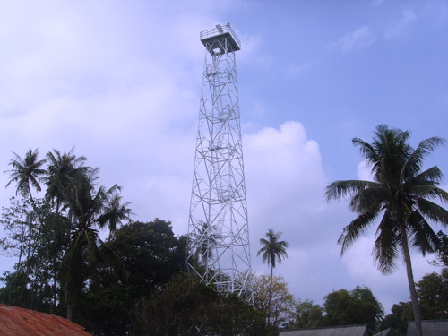
Le Meule Light, Sabang, March 2010
Aceh Department of Marine and Fisheries photo
Eastern Aceh Besar (North Aceh) Regency Lighthouses Pulau Buru (Buro) (2)
Date unknown (station established 1889). Active; focal plane 14 m (46 ft); white flash every 3 s. 15 m (49 ft) barbell-shaped white fiberglass tower, centered on a square base. Michael Thirnbeck has an aerial photo and Bing has a satellite view. This lighthouse escaped serious damage by the 2004 tsunami because it is built on an isolated island too small (only 50 m (160 ft) in diameter) to trigger the great waves to rise up to destructive size. The original lighthouse was a hexagonal skeletal tower with lantern. Located about 15 km (9 mi) north of Banda Aceh and a similar distance south of Pulau Weh. Accessible only by boat. Site status unknown. Admiralty F1315; NGA 22268. Teluk Krueng Raya (Krueng Raja) (1)
Date unknown. Inactive. 15 m (49 ft) square pyramidal skeletal tower, painted white. Phermana Rendy has a 2016 photo showing the new (taller) tower next to the original tower and Google has a satellite view of the two towers. Located on the waterfront of Krueng Raya, an industrial harbor about 25 km (15 mi) east of Banda Aceh. Site status unknown. Teluk Krueng Raya (Krueng Raja) (2)
Date unknown. Active; focal plane about 30 m (98 ft); white flash every 3 s. Approx. 28 m (92 ft) square pyramidal skeletal tower, painted white. Phermana Rendy has a 2016 photo showing the new, taller tower next to the original tower. Site status unknown. Admiralty F1317; NGA 22272. Krueng Raya (Krueng Raja, Ujung Batukapal)
Date unknown. Active; focal plane 35 m (115 ft); white light, 2 s on, 6 s off. 12.5 m (41 ft) white concrete tower. Ruslan Effendi has a distant view and Google has an indistinct satellite view. Located on a promontory sheltering the east side of Krueng Raya bay. Site status unknown. Admiralty F1316; NGA 22276.
Pidie Regency Lighthouses Ujung Pidie
Date unknown. Active; focal plane 60 m (197 ft); three white flashes every 20 s. 40 m (131 ft) skeletal tower with lantern and gallery, painted white. Four blue-roofed keeper's houses. No photo of the tower is available but Google has a satellite view of the station. This lighthouse marks a prominent cape about 80 km (50 mi) east of Banda Aceh and 16 km (10 mi) northwest of Sigli. Site status unknown. ARLHS IDO-344; Admiralty F1319; NGA 22286. Sigli Approach
Date unknown. Active; focal plane 12 m (39 ft); white flash every 3 s. 12 m (39 ft) white fiberglass tower mounted on a square platform supported by piles. No photo available but Google has a satellite view. Located just off the beach at Sigli. Site open, tower closed. Admiralty F1320.2; NGA 22292.
Lhokseumawe City Lighthouses Note: Lhokseumawe is a seaport city of about 180,000 residents; it includes most of Aceh's port facilities.
Kreung Geukueh West Breakwater (2)
Date unknown. Active; focal plane about 15 m (49 ft); green light, 2 s on, 8 s off. Approx. 12 m (39 ft) octagonal cylindrical concrete tower painted green. Daniel Nakaturi has a distant street view, and Google has a satellite view. Kreung Geukueh a general port of entry for Aceh. NGA lists a skeletal tower. Kreung Geukueh a general port of entry for Aceh. Located at the end of the west outer breakwater of Kreung Geukueh. Site status unknown. Admiralty F1321.3; NGA 22300. * Kreung Geukueh West Inner Breakwater
Date unknown. Active; focal plane about 10 m (33 ft); green flash every 3 s. 8 m (26 ft) octagonal cylindrical concrete tower on a square base, painted green. Ibnu Fatani's photo is at right, Daniel Nakaturi has a street view, and Google has a satellite view. Located on the short inner west breakwater of Kreung Geukueh. Site open, tower closed. Admiralty F1321.5; NGA 22305. Kreung Geukueh East Inner Breakwater
Date unknown. Active; focal plane about 10 m (33 ft); red flash every 3 s. 8 m (26 ft) octagonal cylindrical concrete tower on a square base, painted red. The light is in the left background of Ibnu Fatani's photo, Daniel Nakaturi has a distant street view, and Google has a satellite view. Located on the short inner east breakwater of Kreung Geukueh. Site status unknown. Admiralty F1321.4. Kreung Geukueh East Breakwater (2)
Date unknown. Active; focal plane about 15 m (49 ft); red light, 2 s on, 8 s off. Approx. 12 m (39 ft) octagonal cylindrical concrete tower painted red. A photo is available, Daniel Nakaturi has a distant street view, and Google has a satellite view. NGA lists a skeletal tower. Located at the end of the east outer breakwater of Kreung Geukueh. Site status unknown. Admiralty F1321.2; NGA 22304. * Blang Lancang West Range Front
Date unknown. Active; focal plane 40 m (131 ft); white light, 1 s on, 1 s off. 36 m (118 ft) square pyramidal tower with gallery, painted with black and white horizontal bands. No photo available, but Bing has a satellite view. Blang Lancang is an artificial harbor for liquid natural gas shipments, built on the east side of Lhokseumawe. Located on the west side of the harbor. Site status unknown, but the tower would be easy to see from nearby roads. Admiralty F1323.5; NGA 112-22351. 
Inner West Breakwater Light, Kreung Geukueh, September 2017
ex-Google Plus photo by Ibnu Fatani
* Blang Lancang West Range Rear
Date unknown. Active; focal plane 44 m (144 ft); white, red or green light depending on direction, occulting once every 4 s. 44 m (144 ft) square pyramidal tower with gallery, painted with black and white horizontal bands. No photo available, but Bing has a satellite view. Located 170 m (558 ft) west of the front light. Site status unknown, but the tower would be easy to see from nearby roads. Admiralty F1323.51; NGA 22352.
* Blang Lancang Entrance Range Front
Date unknown. Active; focal plane 40 m (131 ft); white light, 1 s on, 1 s off. 36 m (118 ft) square pyramidal tower with gallery, painted with black and white horizontal bands. Zulfitriansyah Putra has a photo of both range lights (also seen at right) and Bing has a satellite view. This is the entrance range for Blang Lancang harbor. Located on the south side of the harbor. Site status unknown, but the tower would be easy to see from nearby roads. Admiralty F1322; NGA 22340. * Blang Lancang Entrance Range Rear
Date unknown. Active; focal plane 45 m (148 ft); white light, occulting once every 8 s. 45 m (148 ft) square pyramidal tower with gallery, painted with red and white horizontal bands. Zulfitriansyah Putra has a photo of both range lights (also seen at right) and Bing has a satellite view. Located 157 m (515 ft) southwest of the front light. Site status unknown, but the tower would be easy to see from nearby roads. Admiralty F1322.1; NGA 22344. Hagu (Lhokseumawe) (2)
Date unknown (station established 1904). Active; focal plane 22 m (72 ft); white flash every 3 s. 20 m (66 ft) iron framework tower, painted white. No photo available, and the tower has not been found in Google's satellite view. The original lighthouse was similar but the focal plane was only 15 m (49 ft). Located in Lhokseumawe, a city about 160 km (100 mi) east of Banda Aceh. Site status unknown. ARLHS IDO-157; Admiralty F1324; NGA 22356. * Lhokseumawe
Date unknown. Active; focal plane 30 m (98 ft); white light, 2 s on, 8 s off. 30 m (98 ft) square skeletal tower painted white. Agus Nasution has a 2017 photo but the tower is very difficult to distinguish in Google's satellite view of the location. NGA lists the light as Lhokseumawe Pier Head, but there is no pier here. Located on the beach near the foot of Merdeka Street in Lhokseumawe. Site open, tower closed. Admiralty F1326; NGA 22360. 
Front (left) and Rear Range Lights, Blang Lancang, January 2018
Google Maps photo by Zulfitriansyah Putra
Aceh Timur (East Aceh) Regency Lighthouses Tanjung Jamboaye (Tanjung Jambuair, Diamantpunt, Diamond Point) (2)
Date unknown (station established 1905). Active; focal plane 44 m (144 ft); one long (1.5 s) white flash every 5 s. 40 m (131 ft) skeletal tower on an octagonal base. Lighthouse painted white. Coast guard station building. No photo available but Bing has a satellite view of the station. The original lighthouse was a 26 m (85 ft) screwpile tower. This lighthouse is on Sumatra's northern "shoulder," marking the south side of the entrance to the Strait of Malacca. Located on Tanjung (cape) Jamboaye, about 40 km (25 mi) east of Lhokseumawe. Site status unknown. ARLHS IDO-083; Admiralty F1327; NGA 22364.
* Idi (Idi Rayeuk, Edie Rajut)
1903. Active; focal plane 20 m (66 ft); white flash every 3 s. 20 m (66 ft) hexagonal iron skeletal tower with lantern and gallery, painted white. No photo available but Google has a satellite view. Located just off the main highway in downtown Idi Rayeuk, the capital of East Aceh Regency, about 50 km (30 mi) southeast of Tanjung Jambuair. Site open, tower closed. ARLHS IDO-133; Admiralty F1327.5; NGA 22368. Ujung Peureula (Peureulak)
Date unknown. Active; focal plane 12 m (39 ft); two white flashes every 6 s. 12 m (39 ft) square skeletal tower, painted white and mounted on a platform supported by piles. No photo available but Google has an indistinct satellite view. Located off a low cape near Peureulak. Accessible only by boat. Site open, tower closed. Admiralty F1327.8; NGA 22369. Kuala Beukah
Date unknown. Active; focal plane 16 m (52 ft); two white flashes every 10 s. 14 m (46 ft) square white skeletal tower. No photo available and the tower has not been found in Google's satellite view. Located about 3 km (2 mi) south of Ujung Peureula. Site status unknown. Admiralty F1328; NGA 22372. * Kuala Langsa
Date unknown. Active; focal plane 20 m (66 ft); three white flashes every 10 s. 15 m (49 ft) square pyramidal skeletal tower painted white. Part of Lukmanul Hakim's street view is at right, and Edy Susanto has a 2018 photo, and Google has a satellite view. NGA lists this light as Kuala Beukah, an obvious error. Located on the waterfront of the estuary leading to Langsa, a city of about 150,000 residents. Site open, tower closed. Admiralty F1330.7; NGA 22392. 
Kuala Langsa Light, Aceh Timur, June 2015
Google Plus street view by Lukmanul Hakim
Langsa Range Rear
Date unknown. Active; focal plane 18 m (59 ft); white light, 2 s on, 2 s off. 18 m (59 ft) square skeletal tower, painted white and mounted on a platform supported by piles. No photo available but Google has a satellite view. This is an approach range for Langsa. The front range is on a similar tower 9 m (30 ft) tall. Located just offshore near Langsa. Accessible only by boat. Site open, tower closed. Admiralty F1330.1; NGA 22380.
Tamiang Regency Lighthouse Ujung Tamiang
Date unknown. Active; focal plane 44 m (144 ft); three white flashes every 20 s. 40 m (131 ft) square skeletal tower, painted white, rising from an octagonal 2-story white concrete building. Syamsul Bahri has a 2017 closeup photo, Guntur Ardhana has a photo of the station and the base of the lighthouse, and Google has a satellite view. This is a staffed coast guard station. Located just off a swampy cape about 35 km (22 mi) east of Langsa. Site status unknown. ARLHS IDO-345; Admiralty F1334; NGA 22394.
Information available on lost lighthouses:
Notable faux lighthouses:
Lighthouses of Indonesia: Western Aceh, Sumatra
Indonesia has been independent since 1945 after having been the Dutch East Indies for more than 350 years. It is a huge country, stretching along both sides of the Equator for more than 46 degrees of longitude (roughly 5100 km or 3200 miles). Comprised of some 17,000 islands (more than 6000 inhabited islands), it has hundreds of major aids to navigation. Unfortunately, it's difficult to know how many of these aids can be considered lighthouses. Information about them is scarce and photos are even scarcer. Official light lists contain dozens of entries for "framework towers" and "white beacons," providing little guidance for the lighthouse fan.
Sumatra (or, as Indonesians prefer, Sumatera) is the world's sixth largest island and the westernmost of the major islands of Indonesia. It is separated from Malaysia to the north by the Malacca Strait, from Borneo to the northeast by the broad Karimata Strait, and from Java to the southeast by the Sunda Strait. Its south coast faces the open Indian Ocean.
Located at the northwestern end of Sumatra, Aceh was the scene of a lengthy and sometimes violent separatist movement, first against Dutch control and then against Indonesian administration. Following the disastrous tsunami of 26 December 2004 a peace agreement, negotiated with the help of Finnish diplomats, was signed in August 2005. Aceh is governed not as a province of Indonesia but as a "special territory" enjoying a considerable degree of autonomy. The capital is Banda Aceh and the territory has a population of roughly four million. This page includes lighthouses of the western half of the territory, facing the open Indian Ocean. There's another page for Eastern Aceh.
The Indonesian word for a lighthouse is mercusuar. The phrase menara suar, which includes the Arabic word menara, is sometimes used instead. Tanjung and ujung are words for capes, pulau is an island, selat is a strait, and teluk is a harbor, and pelabuhan or labuan is a port.
Aids to navigation in Indonesia are operated and maintained by the Directorate General of Sea Transportation.
ARLHS numbers are from the ARLHS World List of Lights. Admiralty numbers are from volume F of the Admiralty List of Lights & Fog Signals. U.S. NGA List numbers are from Publication 112. General Sources Lighthouses in Indonesia
Photos by various photographers available from Wikimedia; most of the photos are historic. World of Lighthouses - Indonesia
Photos by various photographers available from Lightphotos.net. Online List of Lights - Indonesia
Coming soon: photos by various photographers posted by Alexander Trabas. GPSNavigationCharts
Navigation chart information for Aceh. 
Breueh Light, Aceh Besar, 2013
Ministry of Culture and Education photo
West Coast (Indian Ocean) Lighthouses Aceh Singkil Regency Lighthouses
* Singkil (Singkel) (2)
Date unknown (station established 1912). Active; focal plane 33 m (108 ft); white flash every 6 s. 30 m (98 ft) skeletal tower, painted white. Delimawati Zalukhu has a distant photo, (a portion is at right), and aerial photo is available, and Google has a satellite view. A 1917 coast pilot lists the original light with a focal plane of 21 m (69 ft). Located near the ferry terminal of Pasar Singkel in the extreme southern end of Aceh. Site open, tower closed. ARLHS IDO-279; Admiralty F1267; NGA 23292. * Singkil (Singkel) Wharf
Date unknown. Active; focal plane about 18 m (59 ft); light characteristic unknown. Approx. 18 m (59 ft) round barbell-shaped white tower. Sahidin Pandapotan Lubis has a 2016 photo and Google has an indistinct satellite view. Located at the commerical pier of Singkil about 1 km (0.6 mi) west of the ferry pier. Site open, tower closed. Admiralty F1268. Karang Rumambi
Date unknown. Active; focal plane 14 m (46 ft); two red flashes every 10 s. 14 m (46 ft) square pyramidal skeletal tower, painted white and mounted on a square platform supported by piles. No photo available but Google has a satellite view. Located at the end of a shoal about 8 km (5 mi) southwest of Singkel. Accessible only by boat. Site status unknown. Admiralty F1267.5; NGA 23291. Pulau Sarangalu (Sarang Uln)
Date unknown. Active; focal plane 41 m (135 ft); white flash every 5 s. 40 m (131 ft) tapered square skeletal tower painted white. Four 1-story coast guard station buildings. No photo available but Bing has a good satellite view of the station. Located on a small island at the south end of the Banyak Islands, a group of islands between the mainland and the larger island of Simeulue, about 50 km (30 mi) west of Singkil. Accessible only by boat. Site status unknown. Admiralty F1273; NGA 23304. 
Singkil Light, Singkil, July 2017
Google Maps photo by Delimawati Zalukhu
Pulau Bagu (2)
Date unknown. Active; focal plane 45 m (148 ft); four white flashes every 18 s. Approx. 40 m (131 ft) square skeletal tower with gallery, painted white. No photo available but Google has a satellite view. The earlier light here had a focal plane of 32 m (105 ft). Located on the north point of an island sheltering the harbor of Pulau Banyak. Accessible only by boat. Site status unknown. Admiralty F1271.5; NGA 23295. Pulau Banyak (Pulau Baleh, Pulau Balai)
Date unknown. Active; focal plane 8 m (26 ft); white flash every 5 s. 7 m (23 ft) square white pyramidal skeletal tower. Hafiz Kurniawan has a 2017 photo, another photo is available and Google has a distant satellite view. Located at the foot of the pier at Pulau Balai (Pulau Banyak), the principal settlement in the Banyak Islands. Site open, tower closed. Admiralty F1271; NGA 23296.
Simeulue Regency Lighthouses Note: Simeulue is a large island about 130 km (80 mi) off the coast of West Aceh. The island was near the epicenter of the great earthquake of 26 December 2004 and suffered another major earthquake several months later. The two earthquakes tilted the entire island, raising the west coast by about 2 meters and dropping the east coast a similar amount. The island has a population of about 85,000.
* Teluk Sinabang
2014. Active; focal plane 20 m (66 ft); white flash every 5 s. 18 m (59 ft) square cylindrical skeletal tower, painted white. Suhra Ilyas's evening photo is at right, Wan Zulkarnain Barus has a photo, and Google has an indistinct satellite view. Teluk Sinabang is a magnificent natural harbor on the southeastern coast of Simeulue. Located at the base of the main pier at Sinabang. Site open, tower closed. Admiralty F1273.7. Ujung Babang
Date unknown (2008?). Active; focal plane 40 m (131 ft); white flash every 3 s. 25 m (82 ft) square cylindrical skeletal tower, painted white. No photo available but Google has a satellite view. Located on heights at the east side of the entrance to the harbor of Sinabang. Site status unknown. Admiralty F1274.5; NGA 23308. Pulau Babi
Date unknown. Active; focal plane 32 m (105 ft); white flash every 5 s. Approx. 27 m (89 ft) square skeletal tower, painted white. No photo available but Bing has a satellite view. Babi is a small island about 50 km (30 mi) southeast of Pulau Simeulue. Located on the west side of the island. Accessible only by boat. Site status unknown. Admiralty F1273.5; NGA 23305. Pulau Tepak (Pulau Tapah)
Date unknown. Active; focal plane 100 m (328 ft); white flash every 9 s. Approx. 30 m (98 ft) square skeletal tower painted white. No photo available and the tower has not been found in Google's satellite view. This light has a range of 33 km (20 mi). Located on the summit of a high island off the southwest coast of Simeulue. Accessible only by boat. Site status unknown. Admiralty F1281; NGA 23306. Pulau Simeulue Cut
2006. Active; focal plane 90 m (295 ft); two white flashes every 12 s. Approx. 30 m (98 ft) square skeletal tower painted white. No photo available but Bing has an indistinct satellite view. Listed by NGA as "Pulau Simeuloe," this light has a range of 33 km (20 mi). Located on the summit of an uninhabited high island off the central west coast of Simeulue. Accessible only by boat. Site status unknown. Admiralty F1280; NGA 23307. Pulau Salaut Besar
Date unknown. Active; focal plane 44 m (144 ft); three white flashes every 20 s. Approx. 40 m (131 ft) square skeletal tower painted white. No photo available but Google has a satellite view. This is a coast guard station with numerous buildings. Located on a small island about 40 km (25 mi) northwest of the northern tip of Simeulue. Accessible only by boat. Site status unknown. Admiralty F1279; NGA 23318. 
Teluk Sinabang Light, Simeulue, April 2018
ex-Google Plus photo by Suhra Ilyas
Tinggi
Date unknown. Active; focal plane 40 m (131 ft); white flash every 3 s. 30 m (98 ft) skeletal tower, painted white. No photo available, but Bing has a satellite view. The lighthouse guides vessels approaching Simeulue Barat (North Simeulue), a port on the northeast coast of Simeulue. Located on a small island about 4 km (2.5 mi) off the coast of Simeulue. Accessible only by boat. Site status unknown. ARLHS IDO-341; Admiralty F1278; NGA 23310. Ujung Sirih
Date unknown. Active; focal plane 15 m (49 ft); red flash every 7 s. 15 m (49 ft) square skeletal tower painted red and mounted on a square platform supported by piles. No photo available but Bing has a satellite view. Located at the east side of the entrance to the bay of Lhok Dalam on the central east coast of Simeulue. Accessible only by boat. Site open, tower closed. Admiralty F1277; NGA 23310.5. Pulau Siumat
Date unknown. Active; focal plane 42 m (138 ft); white flash every 6 s. Approx. 25 m (82 ft) square cylindrical skeletal tower, painted white. No photo available, but Google has a satellite view. Siumat is a small island about 16 km (10 mi) off the central east coast of Simeulue. Located at the east end of the island. Site status unknown. Accessible only by boat. Admiralty F1276; NGA 23311.
Aceh Selatan (South Aceh) Regency Lighthouses
* Tapaktuan Port
Date unknown. Active; focal plane 30 m (98 ft); white flash every 5 s. 20 m (66 ft) square skeletal tower with gallery painted white. Toyib Kusuma Jaya has a 2018 photo, Muhammad Wahyu has another photo, a third photo is available and Google has an indistinct satellite view. Located on the waterfront in Tapaktuan, the capital of South Aceh Regency. Site appears open, tower closed. Admiralty F1283.5. Ujung Kupiah (Tapaktuan) (2?)
Date unknown. Active; focal plane 56 m (184 ft); white flash every 5 s. Approx. 25 m (82 ft) square cylindrical skeletal tower, painted white. Sandiri San has an aerial photo and Google has a satellite view. Located on a promontory on the southwest side of Tapaktuan. Site status unknown. Admiralty F1284; NGA 23320. Labuhon Haji Range Front
Date unknown. Active; focal plane about 14 m (46 ft); light characteristic unknown. Approx. 14 m (46 ft) square skeletal tower with gallery. The light is on the left in the photo at right, Isnaidi Chanelaja has a 2018 photo of the two lights, and Google has a satellite view. Located offshore at Labuhan Haji. Accessible only by boat, but easily seen from shore. Site open, tower closed. Labuhon Haji Range Rear
Date unknown. Active; focal plane about 20 m (66 ft); light characteristic unknown. Approx. 20 m (66 ft) square skeletal tower with gallery. The light is on the right in the photo at right, Isnaidi Chanelaja has a 2018 photo of the two lights, and Bing has a satellite view. Located offshore at Labuhan Haji. Accessible only by boat, but easily seen from shore. Site open, tower closed. 
Labuhon Haji Range Lights, South Aceh, March 2010
Aceh Department of Marine and Fisheries photo
Aceh Barat (West Aceh) Regency Lighthouses Susoh (Ujung Seurangga)
Date unknown. Active; focal plane 10 m (33 ft); green flash every 5 s. 10 m (33 ft) round barbell-shaped tower mounted on a square platform supported by piles. Entire lighthouse is green. Sarjanuddin Jusuf has a photo and Bing has a satellite view. Located off a sand spit at Susoh. Site open, tower closed. Admiralty F1290; NGA 23324. * Teluk Susoh
Date unknown. Active; focal plane 12 m (39 ft); white flash every 3 s. 7 m (23 ft) square skeletal tower, painted white. Sarjanuddin Jusuf has a photo and Bing has a satellite view. Located near the pier at Susoh. Site open, tower closed. Admiralty F1291; NGA 23322. Ujung Raya (Ujung Raja)
Date unknown. Active; focal plane 42 m (138 ft); four white flashes every 20 s. 40 m (131 ft) square skeletal tower, painted white. No photo available but Google has a satellite view. Located on a remote, rounded headland in Nagan Raya regency. Site status unknown. Admiralty F1289; NGA 23326.
* Ujung Kareueng (2?)
Date unknown (2005?). Active; focal plane 27 m (89 ft); white light, 2 s on, 6 s off. 25 m (82 ft) square skeletal tower with gallery, painted white. No photo available but Bing has a satellite view and Google has a distant street view. This area was devastated by the 2004 tsunami and the original lighthouse must have been destroyed. Located on a promontory at Muelaboh, the capital of West Aceh Regency. Site status unknown but probably open, tower closed. ARLHS IDO-350; Admiralty F1292; NGA 23328. * Teluk Muelaboh
2014. Active; focal plane 30 m (98 ft); white flash every 3 s. 26 m (85 ft) square skeletal tower painted white. Zul Irfan Ivan Gondrong's view from the sea is at right and Google has an indistinct satellite view. Located at the base of a pier at Muelaboh. Site open, tower closed. Admiralty F1291.7.
Aceh Jaya Regency Lighthouses Krueng Teunom
Date unknown. Active; focal plane 34 m (111 ft); red flash every 7.5 s. 30 m (98 ft) skeletal tower, painted white. No photo available but Google has a satellite view. Located at the Teunom River entrance northwest of Suak Uleue and about 50 km (30 mi) northwest of Muelaboh. (The river entrance is blocked by a bar, so this must be a coastal light rather than a harbor light.) Site status unknown. ARLHS IDO-149; Admiralty F1292.2; NGA 23328.5. Ujung Baro
Date unknown. Active; focal plane 60 m (197 ft); two white flashes every 10 s. 30 m (98 ft) square skeletal tower, painted white. No photo available but Google has a satellite view. Located on a tombolo (island) just off a promontory near Alue Titi. Site status unknown. ARLHS IDO-347; Admiralty F1292.35; NGA 23329.5. Pulau Rangas
Date unknown. Active; focal plane 50 m (164 ft); white flash every 5 s. NGA provides no description of this light; Google's satellite view reveals what is probably a round white skeletal or fiberglass tower at least 15 m (49 ft) tall. No photo available. Located on a small island about 3 km (1.75 mi) southwest of Ujung Baro. Accessible only by boat. Site status unknown. ARLHS IDO-261; Admiralty F1292.3; NGA 23329. 
Teluk Muelaboh Light, Muelaboh, October 2016
Google Plus photo by Zul Irfan Ivan Gondrong
Pulau Raya
Date unknown. Active; focal plane 72 m (236 ft); two quick white flashes every 5 s. Approx. 15 m (49 ft) round white skeletal tower with gallery. No photo available but Google has a satellite view. Located at the northwest corner of Pulau Raya, a triangular island just off the coast near Sampoiniet. Accessible only by boat. Site status unknown. Admiralty F1292.5; NGA 23330. Ujung Tangkura
Date unknown. Active; focal plane 45 m (148 ft); three quick white flashes every 5 s. Approx. 20 m (66 ft) square skeletal tower with gallery. No photo available but Google has a satellite view. Located on a prominent cape north of Jaya. Site status unknown. Admiralty F1292.7; NGA 23331.
North Coast Lighthouses Western Aceh Besar (North Aceh) Regency Lighthouses
Pulau Rusa
Date unknown. Active; focal plane 119 m (390 ft); white flash every 3 s. 10 m (33 ft) square skeletal tower, painted white. No photo available but Google has a satellite view. Located on a small island off a promontory about 15 km (9 mi) south of Leupung on the west coast of Aceh Besar. Accessible only by boat. Site status unknown. Admiralty F1293; NGA 22296. Pulau Bunta (Ujung Mane)
Date unknown. Active; focal plane 90 m (295 ft); four white flashes every 20 s. Approx. 40 m (131 ft) square skeletal tower with gallery, painted white, mounted atop a square 1-story equipment building. The lantern has been removed. Four 1-story coast guard station buildings. A 2013 photo is at right, Aiyub Muchtar also has a 2013 photo (halfway down the page), and Google has a satellite view of the light station. This light marks the beginning of the approach to Banda Aceh from the Indian Ocean. Pulau Bunta is an island off the extreme northwestern tip of Sumatra. Located at the western tip of the island, about 25 km (15 mi) west of Banda Aceh. Accessible only by boat. Site status unknown. Admiralty F1295; NGA 22238. Pulau Benggala
Date unknown. Active; focal plane 28 m (92 ft); white flash every 5 s. 15 m (49 ft) "white beacon," probably a round white fiberglass tower. No photo available, and the tower is barely visible in Bing's satellite view of the island. Located on a rocky islet about 8 km (5 mi) northwest of Pulau Brueh. Accessible only boat. Site status unknown. Admiralty F1301; NGA 22234. 
Pulau Bunta Light, Aceh Besar, 2013
Aceh Tourism Agency photo
** Breueh (Pulau Brueh, Pulau Bras, Willemstoren)
1875. Active; focal plane 160 m (525 ft); two white flashes every 10 s. 44 m (144 ft) round stone tower with lantern and gallery, painted red with one very broad white horizontal band. 5th order clamshell Fresnel lens (last photo on the page) in use. This is a staffed station with several station buildings. A photo is at the top of this page, Akhir Syahputra has a fine 2016 photo, Irhamuddin Guna has a 2013 closeup, Wikimedia has three historic photos from the collection of the Amsterdam Tropenmuseum, and Google has a satellite view. This light marks the extreme northwestern corner of Indonesia, the island of Brueh off the northwestern end of Sumatra. Breueh was devastated by the tsunami of 26 December 2004 but this lighthouse was far above the waves. Some of its support buildings were destroyed by the earthquake, however. Located at the northern tip of Brueh, about 40 km (25 mi) northwest of Banda Aceh. There are ecotours to the island, and the light station is accessible by road; it's a walk of 4 km (2.5 mi) from the nearest fishing village. Site open, tours by the lighthouse staff of the station and tower can be arranged. ARLHS IDO-051; Admiralty F1302; NGA 22236. Pulau Dedap (Pulau Deudab, Ujung Umpee)
Date unknown. Active; focal plane 40 m (131 ft); white flash every 4 s. 10 m (33 ft) barbell-shaped white fiberglass tower. Qu Syairy has a view from the sea, and Bing has a satellite view. Located on a small "island," really a peninsula, at the southeastern tip of Pulau Nasi, an island about 15 km (9 mi) west of Banda Aceh. Accessible only by boat. Site status unknown. Admiralty F1296; NGA 22273.
Banda Aceh City Lighthouses Note: Banda Aceh is the capital of the Aceh region. Built on low ground, the city was devastated by the 2004 tsunami. Largely rebuilt, the city has a population of more than 350,000. Ulee Lheue (Banda Aceh) Range Front
Date unknown. Active; focal plane about 15 m (49 ft); white light, characteristic unknown. Approx. 15 m (49 ft) square skeletal tower painted white and mounted on a square concrete platform supported by piles. Adi Sulay has a 2013 photo, another photo is available, and Google has a satellite view. Ulee Lheue, the harbor district of Banda Aceh, has a new (post-tsunami) ferry port with frequent departures to Pulau Weh, Pulau Brueh, and Pulau Rondo. Located near the mainland shore south of the ferry terminal. Accessible only by boat but easy to view from a waterfront street. Site open, tower closed. It is surprising that these range lights are not listed by the Admiralty. Ulee Lheue (Banda Aceh) Range Rear
Date unknown. Active; focal plane about 22 m (72 ft); white light, characteristic unknown. Approx. 20 m (66 ft) square skeletal tower painted white. No photo available but Google has a satellite view. Located on land about 120 m (400 ft) south of the front light. Site status unknown.
Information available on lost lighthouses:
Notable faux lighthouses:
Lighthouses of Indonesia: Eastern Sumatra
Indonesia has been independent since 1945 after having been the Dutch East Indies for more than 350 years. It is a huge country, stretching along both sides of the Equator for more than 46 degrees of longitude (roughly 5100 km or 3200 miles). Comprised of some 17,000 islands (more than 6000 inhabited islands), it has hundreds of major aids to navigation. Unfortunately, it's difficult to know how many of these aids can be considered lighthouses. Information about them is scarce, and photos are even scarcer. Official light lists contain dozens of entries for "framework towers" and "white beacons," providing little guidance for the lighthouse fan.
Sumatra (or, as Indonesians prefer, Sumatera) is the world's sixth largest island and the westernmost of the major islands of Indonesia. It is separated from Malaysia to the north by the Malacca Strait, from Borneo to the northeast by the broad Karimata Strait, and from Java to the southeast by the Sunda Strait. Its south coast faces the open Indian Ocean.
Sumatra is divided into eight provinces. This page includes lighthouses of the eastern coast including the east coast of North Sumatra province and the province of Riau. (Lighthouses of the west coast of North Sumatra province are described on the Northwestern Sumatra page.)
The Indonesian word for a lighthouse is mercusuar. The phrase menara suar, which includes the Arabic word menara, is sometimes used instead. Tanjung and ujung are words for capes, pulau is an island, selat is a strait, and teluk is a harbor.
Aids to navigation in Indonesia are operated and maintained by the Directorate General of Sea Transportation.
ARLHS numbers are from the ARLHS World List of Lights. Admiralty numbers are from volumes F and K of the Admiralty List of Lights & Fog Signals. (Volume F includes lights north of the Equator and Volume Q includes lights south of the Equator.) U.S. NGA List numbers are from Publication 112. General Sources Lighthouses in Indonesia
Photos by various photographers available from Wikimedia; most of the photos are historic. World of Lighthouses - Indonesia
Photos by various photographers available from Lightphotos.net. Online List of Lights - Indonesia - Volume F and Volume Q
Coming soon: photos by various photographers posted by Alexander Trabas. GPSNavigationCharts
Nautical charts for the Malacca Strait area. 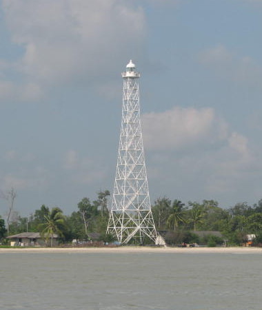
Tanjung Medang Light, Pulau Rupat, April 2006
ex-Panoramio photo by Seiichi Okawa; used by permission
North Sumatra Province East Coast Lighthouses Deli Serdang Regency (Belawan Area) Lighthouses
Nipah Larangan (Nipahlarangang) (2)
2014(?) (station establishment date unknown). Active; focal plane 44 m (144 ft); three white flashes every 20 s. 40 m (131 ft) octagonal concrete tower with lantern and galley, painted white, rising from an octagonal building. Several coast guard station buildings. Google has a satellite view. However, the lighthouse is now critically endangered. Maringan Tobing has an August 2017 photo showing the tower with a lean of at least 15° (like the Leaning Tower of Pisa). We don't know if this is caused by storm damage or a poor foundation. Pak Ivan Setiawan's photo of the original lighthouse is at right. Located on a low cape a short distance east of Kuala Besar and about 16 km (10 mi) north of Belawan. Site status unknown. ARLHS IDO-172; Admiralty F1352; NGA 22400. Belawan (Deli River) (?)
Date unknown (lightship station established 1890). Inactive at least since 2015. 20 m (66 ft) green tower, presumably on a platform supported by piles. No photo available and the light is not seen in Google's satellite view. This light was dropped from the 2015 NGA List. Located on a shoal about 4 km (2.5 mi) offshore and 10 km (6 mi) north of the entrance to Belawan harbor. Accessible only by boat. Site open, tower closed. ex-Admiralty F1355; ex-NGA 22408. Belawan Beacon II (Common Rear)
Date unknown. Active; focal plane 17 m (56 ft); white light, 3 s on, 3 s off. 14 m (46 ft) square skeletal tower with gallery, painted with black and white horizontal bands. No photo available and the light is not seen in Google's satellite view. This is the rear light for both inbound and outbound ranges. Located about 2.5 km (1.5 mi) off the harbor entrance at Belawan, an important port and terminal for ferries crossing the Strait of Malacca to Penang, Malaysia. Site and tower closed. ARLHS IDO-109; Admiralty F1356; NGA 22416. Belawan Beacon V (Range Rear)
Date unknown. Active; focal plane 15 m (49 ft); white light, 3 s on, 3 s off. 12 m (39 ft) square skeletal tower with gallery, painted white. Hadanata Lim has a photo of the lighthouse in action and Google has a satellite view. This is the rear light of a harbor approach range. Located on a shoal in Belawan harbor. Site and tower closed. Admiralty F1362.1; NGA 22428.
Serdang Bedagai Regency Lighthouses Tanjung Sibungabunga
Date unknown. Active; focal plane 21 m (69 ft); white flash every 3 s. 19 m (62 ft) octagonal cylindrical white concrete tower with two galleries. Galang Pandu Satria has a photo and Google has a satellite view. Located near the waterfront in Serdang Bedagai northeast of Medan. Site status unknown. Admiralty F1374.5; NGA 22449. 
Original Nipah Larangan Light, Belawan, May 2012
photo copyright Pak Ivan Setiawan; permission requested
Gosong-Gosong Bunga (Bunga Banks)
Date unknown. Active; focal plane 17 m (56 ft); two white flashes every 5 s. 17 m (56 ft) fiberglass tower, colored black with a red horizontal band and mounted on a platform supported by piles. No photo available and the light is not shown in Google's satellite view. Located on a shoal on the south side of the main channel in the Strait of Malacca 17 km (10.5 mi) northeast of Tanjung Sibungabunga. Accessible only by boat. Site status unknown. Admiralty F1374; NGA 22450. Pulau Berhala (2)
Date unknown. Active; focal plane 192 m (630 ft); four white flashes every 19 s. Approx. 23 m (75 ft) 2-stage octagonal cylindrical concrete tower with lantern and gallery. A distant view (a little over halfway the way down the page) is available and Bing has a distant satellite view. NGA lists a 12 m (39 ft) square skeletal tower. Located on a small, isolated high island about 50 km (30 mi) off the coast in the Strait of Malacca. Probably accessible only by helicopter. Admiralty F1375; NGA 22452. Kuala Bedagai
Date unknown. Active; focal plane 15 m (49 ft); white flash every 5 s. 13 m (43 ft) square white skeletal tower. No photo available and the tower has not been found in Google's satellite view of the area. Located at a beach village at the east end of the regency. Site status unknown. Admiralty F1375.5; NGA 22456.
Batubara Regency Lighthouses Pankalan Dodek (2)
Date unknown (station established 1906). Active; focal plane 18 m (59 ft); white flash every 5 s. 15 m (49 ft) square skeletal tower mounted on a platform supported by piles. Google has a street view and a fuzzy satellite view. The original lighthouse had a focal plane height of 15 m (49 ft). Located on the Pangkalan River waterfront at Pangkalen Dodek, about 20 km (13 mi) northwest of Tanjungbalai. Site status unknown. Admiralty F1376.5; NGA 22458. Kuala Tanjung
2018. Active; focal plane 31 m (102 ft); white flash every 4 s. 15 m (49 ft) white post mounted on a port control building. A 2019 photo is available, but the facilities are too new to appear in Google's satellite view. The Port of Kuala Tanjung is under rapid development as the largest port in Western Indonesia. Located at the end of a long pier at Kuala Tanjung. Site and tower closed. Admiralty F1377.5.
Pulau Pandang (North Brother Island) (2?)
Date unknown. Active; focal plane 63 m (207 ft); white flash every 5 s. Approx. 18 m (59 ft) concrete tower with lantern and gallery, painted white. Amri Hakim has a distant aerial view, a 2018 view is available, and Bing has an indistinct satellite view. NGA lists a 12 m (39 ft) skeletal tower. Located about 15 km (9 mi) northeast of Pulau Salahnama. Accessible only by boat. Site open, tower closed. Admiralty F1378; NGA 22460. Pulau Salahnama (South Brother Island)
Date unknown. Active; focal plane 121 m (397 ft); white flash every 6 s. 30 m (98 ft) square skeletal tower, painted white. Part of Akbar Suhairi's view is at right and Bing has a distant satellite view. This island and its shorter neighbor Pulau Pandang (North Brother) are well-known hazards to navigation along the Sumatran coast. Located on an island in the Strait of Malacca about 20 km (13 mi) off the coast north of Tanjung Balai. Accessible only by boat. Site status unknown. Admiralty F1378.5; NGA 22462. Tanjung Tiram Range Front
Date unknown. Active; focal plane 11 m (36 ft); white flash every 3 s. 11 m (36 ft) white concrete tower enclosed by white daymark panels and mounted on a triangular platform supported by piles. A 2018 photo of the two range lights is available and Google has a satellite view. A 2018 photo of the two range lights is available and Located just offshore on the east side of the entrance to Kuala Batubara. Accessible only by boat. Site open, tower closed. Admiralty F1378.7; NGA 22463. Tanjung Tiram Range Rear
Date unknown. Active; focal plane 15 m (49 ft); three white flashes every 10 s. 15 m (49 ft) white concrete tower enclosed by white daymark panels and mounted on a triangular platform supported by piles. A 2018 photo of the two range lights is available and Google has a satellite view. Located at the shoreline 320 m (1050 ft) south of the front light. Accessible only by boat. Site open, tower closed. Admiralty F1378.71; NGA 22463.5. 
Pulau Salahnama Light, Batubara, October 2014
ex-Google Plus photo by Amri Hakim
Tanjung Tambuntulang
Date unknown. Active; focal plane 14 m (46 ft); two white flashes every 4 s. 14 m (46 ft) square pyramidal white concrete tower mounted on a square platform supported by piles. No photo available but Bing has a distant satellite view. Located about 2 km (1.25 mi) off a promontory about 8 km (5 mi) east of the town of Tanjung Tiram. Accessible only by boat. Site open, tower closed. Admiralty F1379.2; NGA 22471.
Asahan Regency Lighthouses Sungai Asahan Outer Bar
Date unknown. Active; focal plane 18 m (59 ft); red flash every 4 s. 15 m (49 ft) red beacon mounted on a platform supported by piles. No photo available but the shadow of the light is seen in Bing's satellite view. Located off the mouth of the Asahan River, which leads to the port of Tanjungbalai. Accessible only by boat. Site open, tower closed. Admiralty F1382; NGA 22480. Sungai Asahan Range Rear
Date unknown. Active; focal plane 16 m (52 ft); white light, 3 s on, 3 s off. 16 m (52 ft) square white skeletal tower mounted on a platform supported by piles. No photo available but Google has a satellite view. The front light is on a similar tower 13 m (43 ft) tall. Located in the Asahan River off the port of Perikanen. Accessible only by boat. Site open, tower closed. Admiralty F1379.51; NGA 22481.1. Tanjung Siapiapi (Siapi-Api)
Date unknown. Active; focal plane 14 m (46 ft); white flash every 3 s. 14 m (46 ft) square pyramidal white skeletal tower mounted on a square platform supported by piles. No photo available but Bing has a satellite view. Located just off a low cape east of Tanjungbalai. Accessible only by boat. Site open, tower closed. Admiralty F1383.8; NGA 22485.
North Labuhan Batu Regency Lighthouse Tanjung Leidong (Leiding)
Date unknown. Active; focal plane 15 m (49 ft); two white flashes every 8 s. 15 m (49 ft) square pyramidal white skeletal tower mounted on a square platform supported by piles. No photo available but Google has an indistinct satellite view. Located on the west side of the entrance to the Leidong estuary in Kuala Leidong. Site status unknown. Admiralty F1390; NGA 22486.
Labuhan Batu Regency Lighthouses Tanjung Datu
Date unknown. Active; focal plane 14 m (46 ft); white flash every 5 s. 14 m (49 ft) white hourglass-shaped fiberglass tower mounted on a square platform supported by piles. No photo available but Bing has an indistinct satellite view. Located on the west side of the entrance to the Panai estuary. Site status unknown. Admiralty F1384.2; NGA 22487. Pulau Kantan
Date unknown. Active; focal plane 20 m (66 ft); green flash every 4 s. 20 m (66 ft) square pyramidal skeletal tower painted green and mounted on a square platform supported by piles. No photo available but Bing has an indistinct satellite view. Located off the northern tip of an island in the Panai estuary. Accessible only by boat. Site status unknown. Admiralty F1385.5; NGA 22489.
Riau Province Lighthouses Rokan Hilir Regency: Arwah Islands Lighthouses
Pulau Jemur
Date unknown. Active; focal plane 46 m (151 ft); white flash every 5 s. 24 m (79 ft) skeletal tower with lantern and gallery, painted white. An aerial view and another photo (halfway down the page) are available, and Hing Kai Kent has a photo showing the base of the tower, but the island is only a blur in Google's satellite view. Pulau Jemur is the largest of the Arwah island group east of Tanjungbalai in the Strait of Malacca, about 50 km (30 mi) offshore and 75 km (45 mi) from the Malaysian coast. (Malaysia also claims the islands, but the Indonesian Navy maintains the Pulau Batu Mandi station on the easternmost island to establish sovereignty.) The Riau provincial government is interested in developing tourist facilities on Pulau Jemur, but admits that conditions are somewhat primitive at the present time. Accessible only by boat; speedboat transportation is available from Bagansiapiapi. Site status unknown. ARLHS IDO-201; Admiralty F1386; NGA 22484. Pulau Batumandi (Batu Mandi)
Date unknown. Active; focal plane 43 m (141 ft); two white flashes every 10 s. 40 m (131 ft) square skeletal tower with lantern and gallery, mounted on a 2-story concrete keeper's house. Entire lighthouse painted white. This station is staffed by the Indonesian Navy. A photo is at right. Located on a rocky reef near the center of the Malacca Strait, about 13 km (8 mi) east of Pulau Jemur. Accessible only by boat. Site status unknown. Admiralty F1388; NGA 22484.5. 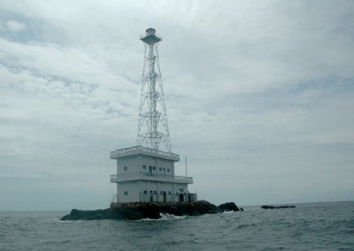
Pulau Batu Mandi Light
anonymous Creative Commons photo (no longer online)
Bengkalis Regency: Pulau Rupat North Side Lighthouses Note: Rupat is a large island, about 40 km (25 mi) in diameter, separated from the mainland of Sumatra by the narrow Rupat Strait.
Pulau Burung
Date unknown. Active; focal plane 13 m (43 ft); red flash every 5 s. 13 m (43 ft) square skeletal tower mounted on a platform supported by piles. No photo available but Bing has a distant satellite view. Located off the west end of Pulau Burung, a small island just off the north coast of Pulau Rupat. Accessible only by boat. Site open, tower closed. Admiralty F1395.2; NGA 22491. Tanjung Medang
Date unknown. Active; focal plane 52 m (171 ft); white flash every 10 s. 50 m (164 ft) square tapered skeletal tower with lantern and gallery, painted white. Several coast guard buildings nearby. Seiichi Okawa's photo is at the top of this page, Melvinas Priananda's photo is at right, and Bing has a good satellite view. Tanjung Medang is an important landmark marking the entrance to the narrow section of the Malacca Strait. Located on a swampy cape at the northern tip of Pulau Rupat. Site status unknown. ARLHS IDO-315; Admiralty F1395; NGA 22492. Morong
Date unknown. Active; focal plane 25 m (82 ft); three white flashes every 15 s. 25 m (82 ft) square tapered skeletal tower with lantern and gallery, painted white. No photo available but Bing has a satellite view. Located at an estuary entrance on the east side of Pulau Rupat. Site status unknown. ARLHS IDO-171; Admiralty F1395.5; NGA 22496.
Bengkalis Regency: Strait of Malacca Main Channel Lighthouses Gosong Raleigh (Raleigh Shoal)
Date unknown. Active; focal plane 16 m (52 ft); two white flashes every 5 s. 13 m (43 ft) tower, probably mounted on a caisson or concrete pier. Lighthouse painted black with one red horizontal band. No photo available and the light is not shown in Google's satellite view. Located on the south side of the main ship channel of the Malacca Strait, northeast of Pulau Rupat. Accessible only by boat. Site status unknown. Admiralty F1396; NGA 22500. Gosong Rob Roy (Rob Roy Bank)
Date unknown. Active; focal plane 16 m (52 ft); two white flashes every 10 s. 13 m (43 ft) tower, probably mounted on a caisson or concrete pier. Lighthouse painted black with one red horizontal band. No photo available and the light is not shown in Google's satellite view. Located on the south side of the main ship channel of the Malacca Strait, east of Pulau Rupat. Accessible only by boat. Site status unknown. Admiralty F1397; NGA 22508. 
Tanjung Medang Light, Pulau Rupat, July 2016
ex-Google Plus photo by Melvinas Priananda
Gosong Clark (Clark Bank)
Date unknown. Active; focal plane 14 m (46 ft); white flash every 3 s. 14 m (46 ft) tower painted white. No photo available and the light is not shown in Google's satellite view. Located on a shoal on the south side of the main channel in the Strait of Malacca, about 25 km (15 mi) north of Pulau Bengkalis. Accessible only by boat. Site status unknown. Admiralty F1398; NGA 22578.
Bengkalis Regency: Pulau Rupat South Side Lighthouse
* Batu Pandang
Date unknown. Active; focal plane 18 m (59 ft); white flash every 3 s. Approx. 15 m (49 ft) square cylindrical white skeletal tower. A photo is at right and Google has an indistinct satellite view. Located on the pier at Batu Pandang on the south side of Rupat Island opposite Dumai city. Site open, tower closed. Admiralty F1401.5; NGA 22511.5.
Dumai City Lighthouses Note: Dumai is an industrial city and seaport on the south side of Rupat Strait. The city has a population of about 300,000. Dumai
Date unknown. Active; focal plane 28 m (92 ft); white flash every 4 s. 25 m (82 ft) white skeletal tower with three galleries. The tower is left of the pier in Roffi Ardinata's aerial view and Google has a satellite view. The nature of this tower is not known. Note: NGA has an incorrect Admiralty number for this light. Located in an industrial park on the east side of Dumai. Site status unknown. Admiralty F1400.05; NGA 22511.1. Selat Rupat
Date unknown. Active; focal plane 43 m (141 ft); white light, 2 s on, 3 s off. Approx. 40 m (131 ft) skeletal tower, painted white. No photo available but Bing has a distant satellite view. Located at the Dumai Industrial Park, on the south side of the Rupat Strait, which separates Pulau Rupat from the mainland. Site status unknown. Admiralty F1402.6; NGA 22523.1.
Bengkalis Regency: Rupat and Bengkalis Straits Lighthouses Selat Rupat G (Tanjung Lebang Outbound Range Front)
Date unknown. Active; focal plane 16 m (52 ft); quick-flashing white light. 16 m (52 ft) square white skeletal tower mounted on a platform supported by piles. No photo available and Google has only a fuzzy satellite view of the area. Located about 5 km (3 mi) northeast of Tanjung Lebang, the south side of the entrance to the Rupat Strait. Accessible only by boat. Site open, tower closed. Admiralty F1401.9; NGA 22520. 
Batu Pandang Light, Pulau Rupat, November 2016
ex-Google Plus photo by erwans st
Selat Rupat F (Tanjung Lebang Range Common Rear)
Date unknown. Active; focal plane 17 m (56 ft); white light, 1 s on, 1 s off. 17 m (56 ft) square white skeletal tower mounted on a platform supported by piles. No photo available and Google has only a fuzzy satellite view of the area. Located 1425 m (0.89 mi) east of the Outbound Range Front Light. Accessible only by boat. Site open, tower closed. Admiralty F1402; NGA 22512. Selat Rupat E (Tanjung Lebang Inbound Range Front)
Date unknown. Active; focal plane 16 m (52 ft); quick-flashing white light. 16 m (52 ft) square white skeletal tower mounted on a platform supported by piles. No photo available and Google has only a fuzzy satellite view of the area. Located 300 m (0.2 mi) southeast of the Common Rear Light. Accessible only by boat. Site open, tower closed. Admiralty F1402.1; NGA 22516. Selat Rupat A
Date unknown. Active; focal plane 16 m (52 ft); three white flashes every 15 s. 13 m (43 ft) square white skeletal tower mounted on a platform supported by piles. No photo available and Google has only a fuzzy satellite view of the area. Located on a shoal about 5 km (3 mi) offshore marking the eastern approach to the Rupat Strait and Dumai. Accessible only by boat. Site open, tower closed. Admiralty F1402.5; NGA 22523. Selat Rupat D
Date unknown. Active; focal plane 14 m (46 ft); white light, 1.5 s on, 1.5 s off. 14 m (46 ft) square white skeletal tower mounted on a platform supported by piles. No photo available and Google has only a fuzzy satellite view of the area. For vessels leaving the Bengkalis Strait, this light marks the point of division between the channels leading to the Rupat Strait and to the open Malacca Strait. Located on a shoal about 10 km (6 mi) north northwest of Tanjung Bakau. Accessible only by boat. Site open, tower closed. Admiralty F1403; NGA 22524. Tanjung Bakau C (Range Rear)
Date unknown. Active; focal plane 29 m (95 ft); white light, 2 s on, 2 s off. 28 m (92 ft) skeletal tower, painted white. No photo available but Google has a satellite view and a distant street view. This is an outbound range for vessels leaving Bengkalis; it shares a front light tower with the Range Rear B light (next entry). Located on the south side of the strait leading to Bengkalis. Site status unknown. ARLHS IDO-293; Admiralty F1404.1; NGA 22536. Tanjung Bakau B (Range Rear)
Date unknown. Active; focal plane 29 m (95 ft); white light, 2 s on, 2 s off. 28 m (92 ft) skeletal tower, painted white. No photo available but Google has a satellite view. This is an inbound range for vessels approaching Bengkalis; it shares a front light tower with the Range Rear C light (previous entry). Located on the south side of the strait leading to Bengkalis. Site status unknown. ARLHS IDO-292; Admiralty F1403.9; NGA 22532.
Tanjung Bakau A (Common Front)
Date unknown. Active; focal plane 15 m (49 ft); quick-flashing white light. 15 m (49 ft) square white skeletal tower mounted on a platform supported by piles. No photo available but Google has a satellite view. Located just offshore, 1 km (0.6 mi) east of Light C and 760 m (0.5 mi) north of Light B. Accessible only by boat but there must be a good view from the nearby Tenggayun Beach. Site open, tower closed. Admiralty F1404; NGA 22528.
Bengkalis Regency and City: Pulau Bengkalis Lighthouses * Bengkalis
Date unknown. Active; focal plane 32 m (105 ft); white flash every 10 s. 30 m (98 ft) tower; the light is apparently on a square skeletal communications tower seen in Google's street view and the photo at right. Bing has a satellite view. Bengkalis is a small city on the south side of the island of Bengkalis, just off the mainland of Sumatra. Located just off the waterfront of Bengkalis. Site status unknown but the tower is easy to see from nearby streets. Admiralty F1407; NGA 22544. Tanjung Jati
Date unknown. Active; focal plane 16 m (52 ft); white light, 2 s on, 6 s off. Approx. 15 m (49 ft) skeletal tower, painted white. No photo available and the light is barely visible in Google's satellite view of the area. Located on the east side of the entrance to the Bengkalis Strait. Site status unknown. Admiralty F1406; NGA 22542. Tanjung Parit
Date unknown. Active; focal plane 42 m (138 ft); white flash every 5 s. 40 m (131 ft) skeletal tower, painted white. No photo available and Google has only a distant satellite view of the area. Located on a swampy cape at the northeastern corner of Bengkalis Island. Site status unknown. ARLHS IDO-320; Admiralty F1413.5; NGA 22580. Tanjung Sekodi
Date unknown. Active; focal plane 31 m (102 ft); white flash every 7.5 s. Approx. 28 m (92 ft) skeletal tower, painted white. No photo available but Google has a distant satellite view. Located on a platform just off a swampy cape at the southeastern corner of Bengkalis Island. Site status unknown. Admiralty F1413.7; NGA 22580.7. 
Bengkalis Light, Pulau Bengkalis, December 2009
Flickr photo by rilham2new the 6th for City of Bengkalis
Kepulauan Meranti (Meranti Islands) Regency Lighthouse Tanjung Menggung
Date unknown. Active; focal plane 16 m (52 ft); white flash every 5 s. 16 m (52 ft) square white skeletal tower mounted on a platform supported by piles. No photo available and Google has only a fuzzy satellite view of the area. Located off the southern tip of Pulau Rangsang. Accessible only by boat. Site open, tower closed. Admiralty F1417; NGA 22590.
Indragiri Hilir Regency (Northern Berhala Strait) Lighthouses Note: The Berhala Strait separates Sumatra from the southern Riau Islands, southwest of Singapore. The strait is generally 25-40 km (15-25 mi) wide. Tanjung Datuk (Tanjung Dato)
Date unknown. Active; focal plane 25 m (82 ft); white flash every 5 s. 25 m (82 ft) "white beacon" on a square platform supported by piles. No photo available but Google has a fuzzy satellite view. Located just off a swampy point on the west side of the Berhala Strait. Accessible only by boat. Site status unknown. ARLHS IDO-300; Admiralty F1429; NGA 22616. Tanjung Bakau
Date unknown. Active; focal plane 15 m (49 ft); two white flashes every 10 s. 15 m (49 ft) "white beacon." No photo available but Bing has a satellite view. Located off a swampy point about 30 km (19 mi) south of Tanjung Datuk. Accessible only by boat. Site status unknown. Admiralty Q0981; NGA 22720.
Information available on lost lighthouses:
Notable faux lighthouses:
Lighthouses of Indonesia: Northwestern Sumatra
Indonesia has been independent since 1945 after having been the Dutch East Indies for more than 350 years. It is a huge country, stretching along both sides of the Equator for more than 46 degrees of longitude (roughly 5100 km or 3200 miles). Comprised of some 17,000 islands (more than 6000 inhabited islands), it has hundreds of major aids to navigation. Unfortunately, it's difficult to know how many of these aids can be considered lighthouses. Information about them is scarce, and photos are even scarcer; if you know about lighthouses in Indonesia, please share that knowledge. . Official light lists contain dozens of entries for "framework towers" and "white beacons," providing little guidance for the lighthouse fan.
Sumatra (or, as Indonesians prefer, Sumatera) is the world's sixth largest island and the westernmost of the major islands of Indonesia. It is separated from Malaysia to the north by the Malacca Strait, from Borneo to the northeast by the broad Karimata Strait, and from Java to the southeast by the Sunda Strait. Its south coast faces the open Indian Ocean.
Sumatra is divided into eight provinces. This page includes lighthouses of the west coast of North Sumatra Province. Lighthouses of the east coast of the province are described on the East Sumatra page.
The Indonesian word for a lighthouse is mercusuar. The phrase menara suar, which includes the Arabic word menara, is sometimes used instead. Tanjung and ujung are words for capes, pulau is an island, selat is a strait, teluk is a bay or harbor, and pelabuhan or labuan is a port.
Aids to navigation in Indonesia are operated and maintained by the Directorate General of Sea Navigation.
ARLHS numbers are from the ARLHS World List of Lights. Admiralty numbers are from volumes F and Q of the Admiralty List of Lights & Fog Signals. U.S. NGA List numbers are from Publication 112. General Sources Indonesian Lighthouses
Historic postcard views from the collection of Michel Forand. Lighthouses in Indonesia
Photos by various photographers available from Wikimedia; most of the photos are historic. World of Lighthouses - Indonesia
Photos by various photographers available from Lightphotos.net. Online List of Lights - Indonesia - Volume F and Volume Q
Coming soon: photos by various photographers posted by Alexander Trabas. 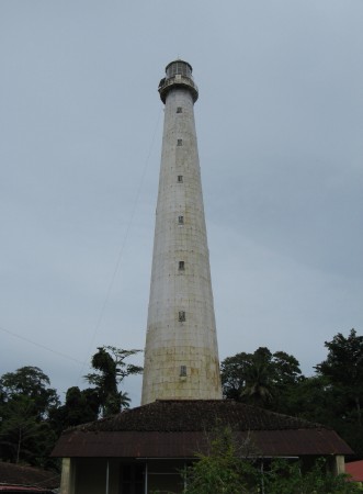
Pulau Bojo Light, Batu Islands, October 2008
photo copyright Dietrich Lange; used by permission
Batu Islands Lighthouses South Nias Regency: Batu Islands Lighthouses Note: The Batu (Stone) Islands are located in the Indian Ocean 50-200 km (30-125 mi) southwest of the North Sumatran coast. There are three principal islands: Tanahbala and Tanahmasa in the south, separated by a narrow channel, and Pini in the north. The Equator passes just to the south of Pini.
* Sigolong Golong
2017. Active; focal plane 12 m (39 ft); white flash every 5 s. 12 m (39 ft) round barbell-shaped white metal and fiberglass tower. Yason Waruwu's photo is at right but the tower is too new to appear in Bing's satellite view. Located on the waterfront at Sigolong Golong, a small port near the southeastern corner of Pulau Tanahbala, the southernmost of the major Batu Islands, about 200 km (125 mi) west northwest of Padang. Site open, tower closed. Admiralty Q0841.1. Pulau Bojo (Bodjo, Boji)
1883. Active; focal plane 119 m (390 ft); white flash every 4 s. 60 m (197 ft) round cast iron tower with lantern and gallery, painted white. Adjoining keeper's houses are occupied by resident keepers. One of Dietrich Lange's photos is at the top of this page and Google has a good satellite view. The purpose of this landfall light is to mark the passage between the Batu Islands and the island of Siberut, leading to the port of Padang. Located on an island just off the south tip of Pulau Tanahbala. Accessible only by boat. Site open, tower open by arrangement with the keepers. ARLHS IDO-070; Admiralty Q0842; NGA 23192. Pulau Sigata (2)
Date unknown (station established 1913). Active; focal plane 116 m (381 ft); white light, 2 s on, 1 s off. 35 m (115 ft) octagonal white concrete tower with lantern and gallery. Several 1-story coast guard station buildings. No photo available but Google has a satellite view. The original lighthouse was a skeletal tower with lantern and gallery. Located on a small island of the Batu group, northwest of Tanahmasa. Accessible only by boat. Site status unknown. ARLHS IDO-076; Admiralty Q0838; NGA 23204. 
Sigolong Golong Light, Batu Islands, May 2017
ex-Google Plus photo by Yason Waruwu
Pulau Simuk
Date unknown. Active; focal plane 43 m (141 ft); one long white flash every 10 s. Approx. 30 m (98 ft) square skeletal tower mounted on a station building. Several additional station buildings. No photo available but Bing has a good satellite view. Located at a small settlement on Pulau Simuk, an isolated island about 32 km (20 mi) west of Pulau Sigata. Accessible only by boat. Site status unknown. Admiralty Q0838.4. Pulau Pono
Date unknown. Active; focal plane 14 m (46 ft); white flash every 5 s. Approx. 10 m (33 ft) white tower. No photo available but Bing has a satellite view. Located on an island about 8 km (5 mi) south of Pulau Tello. Accessible only by boat. Site status unknown. Admiralty Q0838.7; NGA 23209.5. * Pulau Tello (Pulotello, Pulau Hibao Tello)
Date unknown. Active; focal plane 16 m (52 ft); white flash every 4 s. Approx. 13 m (43 ft) square skeletal tower painted white. Edi Wilson has a sunrise photo and Google has a distant satellite view. Located on the main quay at Pulau Tello, an island off the northwestern end of Tanahmasa. Site open, tower closed. Admiralty Q0839.4; NGA 23208. Pulau Marit
Date unknown. Active; focal plane 15 m (49 ft); white flash every 4 s. 15 m (49 ft) white fiberglass tower mounted on a square platform supported by piles. No photo available but Google has a satellite view. Located off the east end of Pulau Marit, a small island off the northwestern tip of Tanahmasa. Accessible only by boat. Site open, tower closed. Admiralty F1234; NGA 23202. Tanjung Batubelobang (Pulau Pini)
Date unknown. Active; focal plane 42 m (138 ft); white flash every 8 s. 30 m (98 ft) skeletal tower, painted white. No photo available but Bing has a satellite view. Pulau Pini is a substantial island, about 40 km (25 mi) long, at the northeast corner of the Batu group. Located at the western tip of the island. Site status unknown. ARLHS IDO-241; Admiralty F1235; NGA 23209. Tanjung Simanusu
Date unknown. Active; focal plane 31 m (102 ft); white flash every 4 s. Approx. 20 m (66 ft) square skeletal tower painted white. No photo available but Bing has an indistinct satellite view. Located on the northeastern corner of Pulau Pini, guiding vessels in the passage between the Batu Islands and the mainland of Sumatra. Site status unknown. Admiralty F1235.5; NGA 23209.2. Karang Ular
Date unknown. Active; focal plane 15 m (49 ft); white flash every 4 s. 15 m (49 ft) square white skeletal tower mounted on a square platform supported by piles. No photo available but Bing has a satellite view. Located on a reef about 8 km (5 mi) east of Tanjung Simanusu. Accessible only by boat. Site open, tower closed. Admiralty F1237; NGA 23210.
Nias Island Lighthouses Note: Nias is a large island (more than 5000 km2) about 140 km (88 mi) off the Sumatran coast and 80 km (50 mi) northwest of the Batu group. It has a substantial population, more than 750,000, although it does not attract many Western tourists. The island is accessible by air and by ferries from Sibolga on the mainland of North Sumatra.
South Nias Regency Lighthouses
Ujung Sumabawa
Date unknown. Active; focal plane 22 m (72 ft); four white flashes every 17 s. 20 m (66 ft) square skeletal tower painted white. No photo available and the tower is not seen in Bing's satellite view of the cape. Located on a promontory about 35 km (22 mi) north of Dalam on the southeast coast of Nias. Site status unknown. Admiralty F1256; NGA 23245.5. * Teluk Dalam
Date unknown. Active; focal plane 32 m (105 ft); white flash every 3 s. Approx. 29 m (95 ft) square skeletal tower with gallery. A photo is at right, Google has a street view, and Bing has an indistinct satellite view. Located on the main quay of Teluk Dalam, a port and resort town at the southern tip of Nias. Site open, tower closed. Admiralty F1255.2; NGA 23236. Tanjung Hele (Teluk Dalam)
Date unknown. Active; focal plane 168 m (551 ft); white flash every 5 s. 8 m (26 ft) white skeletal tower. No photo available; Google has an indistinct satellite view that may show the light. Located on a prominent cape sheltering the south side of Dalam Bay. Admiralty F1255; NGA 23232. * Teluk Lagundri (Lagundi)
Date unknown. Active; focal plane about 12 m (39 ft); white light, characteristic unknown. Hans Jonathan has photo and Bing has a satellite view. Located just off the beach at Lagundri Beach near the southern tip of Nias. Site open, tower closed. Admiralty F1254.6; NGA 23238. Tanjung Soahebohu (Soahebeuheu)
Date unknown. Active; focal plane 35 m (115 ft); four white flashes every 18 s. Approx. 30 m (98 ft) skeletal tower, painted white. No photo available but Bing has an indistinct satellite view. Located at the southwestern tip of Nias. Site status unknown. Admiralty F1254.5; NGA 23239. 
Teluk Dalam Light, Nias, January 2006
photo copyright ilman.only; used by permission
West Nias Regency Lighthouses Pulau Hinaka (Hinako)
1912. Active; focal plane 54 m (177 ft); white flash every 5 s. 32 m (105 ft) square pyramidal cast iron skeletal tower, painted white. Several coast guard station buildings. No photo available but Bing has a satellite view of the station. This lighthouse guides vessels passing Nias to the west. The satellite view suggests that the original lighthouse survives. Located on a small island in the Indian Ocean about 10 km (6 mi) off the west coast of Nias. Accessible only by boat. Site status unknown. ARLHS IDO-198; Admiralty F1254; NGA 23240. Tanjung Sirombu
Date unknown. Active; focal plane 32 m (105 ft); four white flashes every 18 s. Approx. 25 m (82 ft) square skeletal tower painted white. No photo available but Google has a satellite view. The cape is actually a tombolo: an island connected to the mainland by a narrow isthmus. Located midway on the west coast of Nias. Site probably open, tower closed. Admiralty F1254.4; NGA 23244.2.
North Nias Regency Lighthouses
Tanjung Sebua
Date unknown. Active; focal plane 21 m (69 ft); white flash every 4 s. 20 m (66 ft) tapered square skeletal tower painted white. No photo available but Bing has a satellite view. Located on a promontory at the northwestern tip of Nias. Site status unknown. Admiralty F1253; NGA 23247.5. Gosong Baohi
Date unknown. Active; focal plane 28 m (92 ft); white flash every 5 s. 25 m (82 ft) cast iron skeletal tower, painted white. No photo available but Google has an indistinct satellite view. This lighthouse guides vessels to the port of Lahewa. Located on an island off the northwestern coast of Nias. Accessible only by boat. Site status unknown. ARLHS IDO-129; Admiralty F1250; NGA 23260. Pulau Sarangbaung
Date unknown. Active; focal plane 55 m (180 ft); two white flashes every 8 s. Approx. 50 m (164 ft) square pyramidal skeletal communications tower. A photo is available and Bing has an indistinct satellite view. NGA misspells the name as Sarangbuang. Located on a small island about 20 km (13 mi) north of the northern tip of Nias. Accessible only by boat. Site status unknown. Admiralty F1259; NGA 23258.
Gunungsitoli City Lighthouses Tanjung Mbaa (2)
Date unknown. Active; focal plane 75 m (246 ft); white flash every 5 s. 21 m (69 ft) octagonal concrete tower with lantern and gallery. An aerial photo is available and Google has a good satellite view . The light guides vessels approaching Gunungsitoli, the administrative center of the island, on the northeast coast. The original lighthouse was a cast iron skeletal tower. Located on a promontory about 3 km (2 mi) north of Gunungsitoli. Site status unknown. ARLHS IDO-286; Admiralty F1248; NGA 23248. * Gunungsitoli (2?)
Date unknown. Active; focal plane about 13 m (43 ft); yellow (?) flash every 3 s. Approx. 11 m (36 ft) octagonal cylindrical white concrete tower. Andy Bona's photo is at right, Iduansyah Imran has a photo, and Google has a satellite view. NGA lists a "yellow beacon." Located on the waterfront of Gunungsitoli. Site open, tower closed. Admiralty F1248.2; NGA 23256. 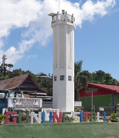
Gunungsitoli Light, Nias, January 2006
ex-Google Plus photo by Andy Bona
Nias Regency Lighthouses Pulau Sumabawa
Date unknown. Active; focal plane 33 m (108 ft); white flash every 4 s. 30 m (98 ft) skeletal tower, painted white. No photo available and the tower is not seen in Bing's satellite view. Located on an island about 12 km (7.5 mi) off the east coast of Nias. Accessible only by boat. Site status unknown. ARLHS IDO-260; Admiralty F1257; NGA 23246. Pulau Bintanah
Date unknown. Active; focal plane 33 m (108 ft); white flash every 5 s. 30 m (98 ft) cast iron skeletal tower, painted white. No photo available but Bing has a satellite view of the island. Located on an island in the center of the Mentawai Strait, midway between Nias and the Sumatra mainland. Accessible only by boat. Site status unknown. ARLHS IDO-112; Admiralty F1262.3; NGA 23267.
Sumatra West Coast Lighthouses Mandailing Natal Regency Lighthouses Pulau Temang
Date unknown (station established 1913). Active; focal plane 65 m (213 ft); white light, 3 s on, 6 s off. 22 m (72 ft) skeletal tower, painted white. Several station buildings. No photo available but Bing has a satellite view of the station. Located at the west end of an island just off the mainland coast near Batahan. Accessible only by boat. Site status unknown. ARLHS IDO-252; Admiralty F1238; NGA 23220. Pulau Labu (Pulau Sidakah)
Date unknown. Active; focal plane 65 m (213 ft); white flash every 5 s. 15 m (49 ft) skeletal tower, painted white. No photo available but Bing has a satellite view. Located at the west end of an island just off the mainland coast about 45 km (28 mi) north of Batahan. Accessible only by boat. Site status unknown. ARLHS IDO-211; Admiralty F1244; NGA 23228. Pulau Ilir
Date unknown. Active; focal plane 94 m (308 ft); white flash every 9 s. Approx. 35 m (115 ft) square skeletal tower with gallery, painted white. Several coast guard station buildings. No photo available but Google has a satellite view of the station. Located on a small island about 2 km (1.25 mi) offshore and 60 km (37 mi) south of Sibolga. Accessible only by boat. Site status unknown. ARLHS IDO-200; Admiralty F1245; NGA 23271.
Central Tapanuli Regency (Sibolga Bay) Lighthouses
Pulau Labulabu Kecil (Labu Labu Kecil)
Date unknown. Active; focal plane 57 m (187 ft); two white flashes every 7 s. 40 m (131 ft) skeletal tower, painted white. No photo available but Bing has a satellite view. Located on a small island on the west side of the southern entrance to the bay of Sibolga. Accessible only by boat. Site status unknown. ARLHS IDO-152; Admiralty F1262.5; NGA 23269. Pulau Mursala (Mansalar, Musala)
Date unknown. Active; focal plane 35 m (115 ft); white flash every 5 s. Approx. 20 m (66 ft ) square skeletal tower with gallery, painted white. No photo available but Google has a satellite view. NGA lists this light as "Pulau Mansalar." Mursala Island is best known for a waterfall that cascades directly into the sea. Located on a northwest end of the island, marking the northern entrance to the bay of Sibolga. Accessible only by boat. Site status unknown. Admiralty F1265; NGA 23259. Pulau Pocan Kecil (Pocan Ketak)
Date unknown. Active; focal plane 12 m (39 ft); three quick white flashes every 12 s. 12 m (39 ft) square pyramidal skeletal tower, painted black with one yellow horizontal band and mounted on a square platform supported by piles. No photo available but Bing has a distant satellite view. Located on the east side of an island in the middle of Sibolga Bay. Accessible only by boat. Site open, tower closed. Admiralty F1263.2; NGA 23285. * Sibolga Fishing Port
Date unknown. Active; focal plane about 18 m (59 ft); white light, characteristic unknown. Approx. 15 m (49 ft) square pyramidal skeletal tower, painted white. The light is at the left of Patpat Gulipat's photo of the waterfront and Google has a good satellite view. Located at the fishing port on the south side of Sibolga. Site open, tower closed. Admiralty F1264.1. * Teluk Sibolga
Date unknown. Active; focal plane 13 m (43 ft); white flash every 5 s. 12 m (39 ft) square pyramidal skeletal tower, painted white. Rahmad Loebiz has the photo at right, A.L. Saraghi has a photo, Randhi Prima has a drone view, Google has a distant street view, and Bing has a distant satellite view. Located on the waterfront in the northern part of Sibolga. Site open, tower closed. Admiralty F1264; NGA 23288. 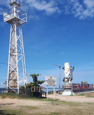
Sibolga Light, Central Tapanuli, October 2017
ex-Google Plus photo by Rahmad Loebiz
Ujung Karang (Gosong Ular)
Date unknown. Active; focal plane 41 m (134 ft); three white flashes every 17 s. 40 m (131 ft) skeletal tower, painted white. Four 1-story coast guard station buildings. No photo available but Google has a satellite view of the station. Located on a peninsula sheltering the west side of the bay of Sibolga. Site status unknown. ARLHS IDO-349; Admiralty F1263; NGA 23284. Ujung Silabi
Date unknown. Active; focal plane 11 m (36 ft); white light, 2 s on, 8 s off. 11 m (36 ft) white fiberglass tower mounted on a square platform supported by piles. No photo available but Bing has a satellite view. Located just off a promontory near the northern border of North Sumatra Province. Accessible only by boat. Site status unknown. Admiralty F1266.3; NGA 23289.
Information available on lost lighthouses:
Notable faux lighthouses:
Lighthouses of Indonesia: Southeastern Sumatra
Indonesia has been independent since 1945 after having been the Dutch East Indies for more than 350 years. It is a huge country, stretching along both sides of the Equator for more than 46 degrees of longitude (roughly 5100 km or 3200 miles). Comprised of some 17,000 islands (more than 6000 inhabited islands), it has hundreds of major aids to navigation. Unfortunately, it's difficult to know how many of these aids can be considered lighthouses. Information about them is scarce and photos are even scarcer. Official light lists contain dozens of entries for "framework towers" and "white beacons," providing little guidance for the lighthouse fan.
Sumatra (or, as Indonesians prefer, Sumatera) is the world's sixth largest island and the westernmost of the major islands of Indonesia. It is separated from Malaysia to the north by the Malacca Strait, from Borneo to the northeast by the broad Karimata Strait, and from Java to the southeast by the Sunda Strait. Its south coast faces the open Indian Ocean. This page includes lighthouses of the southeastern coast and Sunda Strait including the provinces of Jambi, South Sumatra, and Lampung.
This page is probably not complete. Listed here are towers at locations known to be historic Dutch light stations, plus some additional sites at which there is some evidence for a lighthouse. Added to this is an appeal for more information and photos; if you know about lighthouses in Indonesia, please share that knowledge.
The Indonesian word for a lighthouse is mercusuar. The phrase menara suar, which includes the Arabic word menara, is sometimes used instead. Tanjung and ujung are words for capes, pulau is an island, selat is a strait, and teluk is a harbor.
Aids to navigation in Indonesia are operated and maintained by the Directorate General of Sea Transportation.
ARLHS numbers are from the ARLHS World List of Lights. Admiralty numbers are from volume Q of the Admiralty List of Lights & Fog Signals. U.S. NGA List numbers are from Publication 112. General Sources Lighthouses in Indonesia
Photos by various photographers available from Wikimedia; most of the photos are historic. World of Lighthouses - Indonesia
Photos by various photographers available from Lightphotos.net. Online List of Lights - Indonesia
Coming soon: photos by various photographers posted by Alexander Trabas. Maritime and Port Authority of Singapore - Maps
Nautical charts posted by the National Archives of Singapore. 
Tanjung Cukuhbalambing (Vlakken Hoek) Light, August 2016
Google plus photo by hasan s
Jambi Province Lighthouses East Tanjung Jabung Regency (Southern Berhala Strait) Lighthouses Note: The Berhala Strait separates Sumatra from the southern Riau Islands southwest of Singapore. The strait is generally 25-40 km (15-25 mi) wide. Kuala Niur Range Front
Date unknown. Active; focal plane 11 m (36 ft); white flash every 6 s. 11 m (36 ft) white tower on a platform supported by piles. No photo available but Bing has a satellite view. This is the entrance range for the Jambi River and the small port of Niur, at the south end of the Berhala Strait. Located in mid river opposite the town. Accessible only by boat. Site open, tower closed. Admiralty Q0973; NGA 22744.
Kuala Niur Range Rear
Date unknown. Active; focal plane 32 m (105 ft); white flash every 6 s. 30 m (98 ft) square white skeletal tower. No photo available but Bing has a satellite view. Located in the forest on the east side of the Jambi River. Site status unknown. Admiralty Q0973.1; NGA 22748. Pulau Berhala (2)
Around 2012. Active; focal plane 25 m (82 ft); white light, 5 s on, 10 s off. 21 m (69 ft) square skeletal tower, painted white. Muizzuddin Lingga's photo is at right, Muhammad Yani has a 2012 photo, and Bing has an indistinct satellite view. A 2010 photo shows the earlier lighthouse, a square pyramidal skeletal tower. Pulau Berhala is a small island in the middle of the Berhala Strait, which separates the Linga Islands from the Sumatran mainland. Note: There is another Pulau Berhala off northern Sumatra, and another off the coast of Sabah in East Malaysia. For many years, jurisdiction over this Pulau Berhala was in dispute between Jambi and the Riau Islands province; this dispute was resolved in Jambi's favor in 2011. Located on an islet a few miles east northeast of Pulau Berhala. Accessible only by boat. Site status unknown. ARLHS IDO-111; Admiralty Q0976; NGA 22728. Selat Berhala (Berhala Strait, Tanjung Jabung)
Date unknown. Active; focal plane 42 m (138 ft); three white flashes every 14 s. 40 m (131 ft) skeletal tower, painted white. Four 1-story coast guard buildings. No photo available but Bing has a satellite view of the station. Located on Tanjung Jabung, the mainland cape on the south side of the entrance to Berhala Strait, which separates Pulau Singkap from the mainland near the southern end of Riau Province. Site status unknown. ARLHS IDO-273; Admiralty Q0975; NGA 22726. 
Pulau Berhala Light, Berhala Strait, September 2010
Panoramio Creative Commons photo by Muizzuddin Lingga
Sumatera Selatan (South Sumatra) Province Note: The Bangka Strait separates Sumatra from the island of Bangka. Lighthouses on the east side of the strait are described on the Bangka and Belitung page. Banyuasin Regency Lighthouse Tanjung Kampeh
Date unknown. Active; focal plane 16 m (52 ft); white flash every 5 s. Approx. 15 m (49 ft) "white beacon" on a platform supported by piles. No photo available; a fuzzy spot in Bing's satellite view probably locates the lighthouse. Located on a cape at the northern entrance to the Bangka Strait, which separates Sumatra from Bangka. Site status unknown. Admiralty Q0931; NGA 22752.
Ogan Komering Ilir Regency Lighthouses Tanjung Tapa
Date unknown. Active; focal plane 16 m (52 ft); green flash every 5 s. 16 m (52 ft) green beacon. No photo available but Bing has a satellite view. Located off a prominent cape about 40 km (25 mi) southeast of Tanjung Kampeh. Accessible only by boat. Site open, tower closed. Admiralty Q0991; NGA 22884. Pulau Maspari (Lucipara)
Date unknown. Active; focal plane 40 m (131 ft); white flash every 5 s. 48 m (157 ft) square skeletal tower with gallery, painted white. Arwin Novansyah has the view from a nearby village and Google has a satellite view. This lighthouse guides vessels approaching the southern entrance to the Bangka Strait. It is often grouped with the Bangka lighthouses, but the island is in South Sumatra province. Located on a small island about 13 km (8 mi) off the Sumatran coast at the southern entrance to the strait. Accessible only by boat. Site status unknown. ARLHS IDO-024; Admiralty Q0983; NGA 22916. Tanjung Menjangan
Date unknown. Active; focal plane 12 m (39 ft); white flash every 3 s. 12 m (39 ft) "white beacon" on a platform supported by piles. No photo available and the light is not seen in Google's satellite view. Located about 5 km (3 mi) off a low cape and about 50 km (30 mi) south of Pulau Maspari. Accessible only by boat. Site open, tower closed. Admiralty Q1045.7; NGA 22383.5.
Lampung Province Lighthouses East Lampung Regency Lighthouses
Tanjung Bungin
Date unknown. Active; focal plane 12 m (39 ft); white flash every 4 s. 12 m (39 ft) "white beacon" on a platform supported by piles. No photo available and the light is not seen in Google's satellite view. Located about 16 km (10 mi) off the Sumatran coast roughly halfway between Pulau Maspari and the entrance to the Sunda Strait. Accessible only by boat. Site open, tower closed. Admiralty Q1045.5; NGA 22383. Pulau Segama
Date unknown. Active; focal plane 45 m (148 ft); white flash every 5 s. 40 m (131 ft) square tapered skeletal tower with lantern and gallery, painted white. A photo is at right and Bing has a distant satellite view. This lighthouse guides vessels approaching the northern entrance to Sunda Strait. Located on a small island about 30 km (19 mi) off the Sumatran coast and 80 km (50 mi) north of the entrance to the strait. Accessible only by boat. Site status unknown. ARLHS IDO-246; Admiralty Q1043; NGA 23380. * Maringgai
Date unknown. Active; focal plane 14 m (46 ft); white flash every 3 s. Approx. 12 m (39 ft) round white tower. No photo available but Bing has a satellite view. NGA misspells the name as Maginggai. Located on the waterfront just north of the harbor at Maringgai, a fishing port in southeast East Lampung Regency. Site open, tower closed. Admiralty Q0929.6; NGA 23015.
South Lampung Regency (Sunda Strait) Lighthouses Note: The Sunda Strait, separating Sumatra from Java, is the most important passage through the islands of Indonesia. The strait is a broad bay at its southwestern entrance from the Indian Ocean, but it narrows to a minimum width of 24 km (15 mi) at its northeastern entrance from the Java Sea. Lighthouses on the east side of the strait are described on the Southwestern Java page. Pulau Mundu
Date unknown. Active; focal plane 23 m (75 ft); white flash every 6 s. Approx. 18 m (59 ft) square skeletal tower with gallery, painted white. No photo available but Google has a satellite view. Located on a small island just off the coast about 8 km (5 mi) north of Ketapang. Accessible only by boat. Site status unknown. Admiralty Q0929.5; NGA 23014. 
Pulau Segama Light, Java Sea, June 2004
photo copyright Indonesia Sea Turtle Foundation
permission requested
Tanjung Tua
Date unknown. Active; focal plane 50 m (164 ft); three white flashes every 10 s. 15 m (49 ft) skeletal tower, painted white. Tantri Cutte has a view from the sea, Robi Saputra has a 2016 street view taken in the base of the tower, and Google has an indistinct satellite view. This lighthouse is at the southeastern corner of Sumatra and marks the west side of the northern entrance to Sunda Strait. Site open, tower closed. ARLHS IDO-331; Admiralty Q0927; NGA 23016. Pulau Sebuku (Ujung Cukubanding, Cukuh Banding)
Date unknown. Active; focal plane 35 m (115 ft); white flash every 5 s. 10 m (33 ft) (?) square skeletal tower, painted white. No photo available but Google has a satellite view of the station. The tower looks taller than 10 m in the satellite view. Located on the north point of Sebuku, an island at the east side of the mouth of the bay of Panjang. Accessible only by boat. Site status unknown. Admiralty Q0926; NGA 23024. Panjang (Koeala, Bandar Lampung)
Date unknown. Active; focal plane 41 m (134 ft); red light, 2 s on, 3 s off. 40 m (131 ft) tapered square white skeletal tower with gallery. Google has a street view and a fuzzy satellite view. Bandar Lampung is a city of 1.2 million residents, the provincial capital and the metropolis of southeastern Sumatra. The city is built at the head of Panjang Bay. Located in the industrial Panjang harbor at the southeastern edge of the city. Site and tower closed. Admiralty Q0922; NGA 23044.
Kunyit (Kunjit, Teluk Lampung)
Date unknown. Active; focal plane 44 m (144 ft); white flash every 3 s. 40 m (131 ft) tapered square white skeletal tower with gallery. Lina Pesisir has a closeup photo, another photo is available, Malik Ismail has a distant view, and Google has a satellite view. Located behind the waterfront in Bandar Lampung. Site open (but not in a good neighborhood), tower closed. Admiralty Q0920.5; NGA 23052. Serdang (Pulau Serdang)
Date unknown. Active; focal plane 62 m (203 ft); three white flashes every 10 s. 40 m (131 ft) square skeletal tower with lantern and gallery, painted white; lantern painted red. Fajri Gitu has a view from the sea and a second view showing the lower portion of the tower and Google has a satellite view. This lighthouse is on an island on the west side of the Sunda Strait in the mouth of the bay of Panjang. Accessible only by boat. Site status unknown. ARLHS IDO-276; Admiralty Q0926.5; NGA 23020. Ujung Cukucimanuk (Pulau Cimanuk)
Date unknown. Active; focal plane 23 m (75 ft); two white flashes every 7 s. 15 m (49 ft) square pyramidal skeletal tower painted white. No photo available but Google has an indistinct satellite view. Located on a tombolo (an island connected to the mainland by a narrow isthmus) on the east side of the bay of Panjang. Site status unknown. Admiralty Q0923.5; NGA 23036. Maitem (Pulau Maitem)
Date unknown. Active; focal plane 42 m (138 ft); white flash every 8 s. Approx. 40 m (131 ft) square tapered skeletal tower with lantern and gallery, painted white. Part of Eka Bond's photo is at right and Google has a satellite view. Located at the southeastern tip of an island projecting into the west side of the bay of Panjang. Accessible only by boat. Site status unknown. Admiralty Q0923.2; NGA 23064. Pulau Rakata (Krakatau)
Date unknown. Active; focal plane 13 m (43 ft); white flash every 4 s. 13 m (43 ft) round white fiberglass tower mounted on a platform supported by piles. No photo available but Google has a satellite view. Located in the middle of the Sunda Strait, Krakatau (Krakatoa) is a famous volcano that exploded catastrophically on 27 August 1883, killing more than 36,000 people. A group of islands, remnants of the explosion, surround the caldera of the volcano, Pulau Rakata on the southeast side being the largest. The light is just off the southeast coast of Pulau Rakata. Accessible only by boat. Site status unknown. Admiralty Q0927.5; NGA 23022. 
Pulau Maitem Light, Bay of Panjang, September 2016
Google Plus photo by Eka Bond
West Lampung Regency (Indian Ocean) Lighthouses Tanjung Cukuhbalambing (Vlakken Hoek, Balimbing, Belimbing)
1880. Active; focal plane 63 m (207 ft); two white flashes every 10 s. 58 m (190 ft) 16-sided cast iron tower with lantern and gallery, painted white. A 2016 closeup is at the top of this page, Arif Prasetyo has a closeup photo (2nd photo on the page), Lightphotos.net has a nice view and second view by Mikhail Tsyganov, the Rijksmuseum has a scale model, and Bing has a good satellite view of the station. Endangered; Prasetyo visited in early 2011 and found the lighthouse to be in "fragile" condition. A September 2018 photo shows some repair work in progress. Prefabricated at The Hague by Enthoven and Co., this historic lighthouse marks the southern point of Sumatra; it is a landfall light for eastbound ships approaching the Sunda Strait. The tsunami waves created by the eruption of Krakatoa in August 1883 damaged the first floor of the lighthouse and destroyed the keeper's house and other station buildings. The light station is now included in the Tambling National Park. Located on the point of the cape near Balimbing. Site status unknown, but there is road access to the area. ARLHS IDO-082; Admiralty Q0914; NGA 23076.
Pulau Batu Kecil
2007. Active; focal plane 45 m (148 ft); white flash every 6 s. 40 m (131 ft) square pyramidal skeletal with lantern and gallery mounted on a 2-story coast guard station building. Lighthouse painted white. No photo available but Bing has a good satellite view. This is a landfall light for the Sunda Strait, replacing the Vlakken Hoek lighthouse in that function. Located on a small island about 13 km (8 mi) west of Vlakken Hoek. Accessible only by boat. Site status unknown. Admiralty Q0913; NGA 23077. Ujung Cukubatuberagam
Date unknown. Active; focal plane 32 m (105 ft); white flash every 7.5 s. Approx. 25 m (82 ft) square skeletal tower painted white. No photo available but Google has a satellite view. Located on a hook-shaped promontory about 50 km (30 mi) northwest of the historic Vlakken Hoek lighthouse. Site status unknown. Admiralty Q0911; NGA 23086. Ujung Walor (Walur)
Date unknown. Active; focal plane 42 m (138 ft); continuous white light. 40 m (131 ft) skeletal tower, painted white. Several 1-story coast guard station buildings. Google has a satellite view and a street view through the forest. Located on a promontory near Krui. Site status unknown. ARLHS IDO-353; Admiralty Q0910; NGA 23088. Krui (Tanjung Salobu)
1904 (?). Active; focal plane 35 m (115 ft); white flash every 5 s. 13 m (43 ft) square pyramidal skeletal tower, painted white. A distant view is available but the tower is not conspicuous in Google's satellite view of the location. It seems likely that the present tower is the original. Krui is popular with surfers and has a number of resorts. Located on a steep bluff near Krui. Site status unknown. ARLHS IDO-151; Admiralty Q0906; NGA 23092. Pulau Pisang (Teluk Krui)
Date unknown. Active; focal plane 76 m (249 ft); one long white flash every 15 s. 31 m (102 ft) skeletal tower, painted white. Apri Yansa's photo is at right, Said Ardi has a 2018 photo, Egi Ramdhani has a closeup, and Google has a satellite view. Located on an island about 15 km (9 mi) northwest of Krui. Accessible only by boat. Site status unknown. Admiralty Q0904; NGA 23096. 
Pulau Pisang Light, Krui, June 2018
Google Plus photo by Apri Yansa
Information available on lost lighthouses:
Notable faux lighthouses:
Lighthouses of Indonesia: Southwestern Sumatra
Indonesia has been independent since 1945, after having been the Dutch East Indies for more than 350 years. It is a huge country, stretching along both sides of the Equator for more than 46 degrees of longitude (roughly 5100 km or 3200 miles). Comprised of some 17,000 islands (more than 6000 inhabited islands), it has hundreds of major aids to navigation. Unfortunately, it's difficult to know how many of these aids can be considered lighthouses. Information about them is scarce, and photos are even scarcer. Official light lists contain dozens of entries for "framework towers" and "white beacons," providing little guidance for the lighthouse fan.
Sumatra (or, as Indonesians prefer, Sumatera) is the world's sixth largest island and the westernmost of the major islands of Indonesia. It is separated from Malaysia to the north by the Malacca Strait, from Borneo to the northeast by the broad Karimata Strait, and from Java to the southeast by the Sunda Strait. Its south coast faces the open Indian Ocean. This page includes lighthouses of the west coast of the island including the provinces of Bengkulu and West Sumatra.
This page is probably not complete. Listed here are towers at locations known to be historic Dutch light stations, plus some additional sites at which there is some evidence for a lighthouse. Added to this is an appeal for more information and photos; if you know about lighthouses in Indonesia, please share that knowledge.
The Indonesian word for a lighthouse is mercusuar. The phrase menara suar, which includes the Arabic word menara, is sometimes used instead. Tanjung and ujung are words for capes, pulau is an island, selat is a strait, and teluk is a harbor.
Aids to navigation in Indonesia are operated and maintained by the Directorate General of Sea Navigation.
ARLHS numbers are from the ARLHS World List of Lights. Admiralty numbers are from volumes F and Q of the Admiralty List of Lights & Fog Signals. U.S. NGA List numbers are from Publication 112. General Sources Indonesian Lighthouses
Historic postcard views from the collection of Michel Forand. Lighthouses in Indonesia
Photos by various photographers available from Wikimedia; most of the photos are historic. World of Lighthouses - Indonesia
Photos by various photographers available from Lightphotos.net. Online List of Lights - Indonesia - Volume F and Volume Q
Coming soon: photos by various photographers posted by Alexander Trabas. 
Ujung Batumandi Light, Padang, October 2008
photo copyright vault350; permission requested
Bengkulu Province Lighthouses Kaur Regency Lighthouses Tanjung Linau
Date unknown. Active; focal plane 30 m (98 ft); three white flashes every 15 s. Approx. 23 m (75 ft) square pyramidal skeletal tower, probably with lantern and gallery, painted white. No photo available but Bing has a satellite view. Located on a promontory in southernmost Bengkulu province. Site status unknown. Admiralty Q0900; NGA 23098. Tanjung Bandar
Date unknown. Active; focal plane 18 m (59 ft); white flash every 3 s. 16 m (52 ft) square pyramidal skeletal tower, probably with lantern and gallery, painted white. Ipung Ajo has a photo of the stairway in side the tower but the tower is not seen in Google's satellite view. Located on a promontory about 1 km (0.6 mi) south of Bintuhan. Site status unknown. ARLHS IDO-294; Admiralty Q0898; NGA 23099.
South Bengkulu Regency Lighthouse Mana (Tanjung Manna)
Date unknown. Active; focal plane 30 m (98 ft); three white flashes every 15 s. Approx. 23 m (75 ft) skeletal tower with gallery, painted white. Google has a street view but the tower is very difficult to see in Google's satellite view. Located beside a street at the south end of Mana, the capital of the South Bengkulu Regency. Site open, tower closed. Admiralty Q0897; NGA 23100.
Enggano Island Lighthouse Note: Enggano is a substantial island in the Indian Ocean, measuring roughly 30 km by 15 km (19 mi by 9 mi), about 100 km (60 mi) west of Krui. It has only a small population and is rarely visited. Administratively it is attached to the North Bengkulu Regency. Pulau Enggano (Malakoni)
Date unknown. Active; focal plane 60 m (197 ft); four white flashes every 20 s. 40 m (131 ft) square skeletal tower, painted white. This light is probably mounted on the communications tower seen at the left in Aldi Rahmayadi's photo, and Google has an indistinct satellite view. Located at Malakoni, a small ferry port on the east coast of Enggano. Site status unknown. ARLHS IDO-197; Admiralty Q0895; NGA 23101.
Bengkulu City Lighthouse
* Pulaubaai West Breakwater (Lentera Hijau)
Date unknown. Active; focal plane 14 m (46 ft); green flash every 3 s. 9 m (30 ft) round barbell-shaped green tower. Agoni Rahim has a photo and Google has an indistinct satellite view. Pulaubaai is a lagoon converted into a harbor about 15 km (9 mi) south of central Bengkulu. Located on the east breakwater of the dredged entrance to the harbor. Accessible by walking the pier. Site open, tower closed. Admiralty Q0885; NGA 23102.4. * Pulaubaai Range Front
Date unknown. Active; focal plane 8 m (26 ft); quick-flashing white light. 8 m (26 ft) round white concrete tower with gallery. Google has a street view and a satellite view. Located on the south shore of the Pulaubaai harbor. Site open, tower closed. Admiralty Q0885.5; NGA 23102. * Pulaubaai Range Rear
Date unknown. Active; focal plane 12 m (39 ft); white flash every 3 s. 12 m (39 ft) round white concrete tower with double gallery. Google has a street view and a satellite view. Located 270 m (885 ft) southeast of the front light. Site open, tower closed. Admiralty Q0885.51; NGA 23102.2. * Pulaubaai East Breakwater (Lentera Merah)
Date unknown. Active; focal plane 14 m (46 ft); red flash every 2 s. 9 m (30 ft) round barbell-shaped red tower. A photo is available and Google has an indistinct satellite view. Located on the west breakwater of the dredged entrance to the harbor. Accessible by walking the pier. Site open, tower closed. Admiralty Q0885.2; NGA 23102.6. 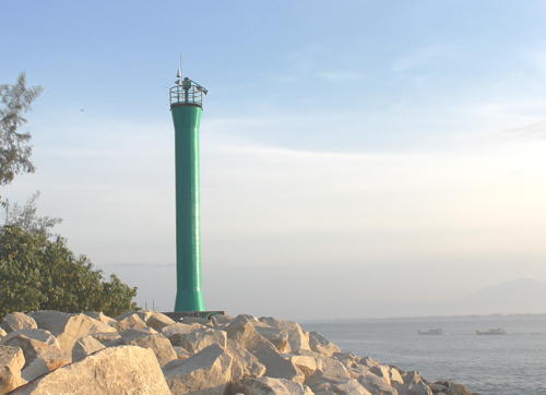
West Breakwater Light, Pulaubaai, August 2015
Google Plus photo
* Pulau Tikus (3?)
Date unknown (station established 1883). Active; focal plane 33 m (108 ft); white light, 5 s on, 5 s off. 30 m (98 ft) tapered square skeletal tower with gallery, painted white, centered on a square 1-story keeper's house. An excellent aerial photo is available, Bayu Plundu has a 2018 photo, a page for the island has several photos and Bing has an indistinct satellite view. Forand has a distant postcard view of what is believed to be the second tower. The light station is reported to be staffed. Note: There is another Pulau Tikus lighthouse in West Malaysia. Located on a tiny island about 10 km (6 mi) southwest of Bengkulu; boat transportation to the island can be hired in Bengkulu. Accessible only by boat. Site open, apparently it is possible to climb the tower. ARLHS IDO-254; Admiralty Q0884; NGA 23104.
North Bengkulu Regency Lighthouse Pulau Mega (Pulau Mego)
Date unknown (clearly recent). Active; focal plane 33 m (108 ft); white flash every 10 s. 30 m (98 ft) skeletal tower with gallery, painted white. The island is the site of a tectonic monitoring station installed in 2008 by Caltech University in a project aimed at measuring tectonic strains in this earthquake-prone area. One of Caltech's photos is at right but the tower has not been located in Google's satellite view. Located on a small island about 160 km (100 mi) west southwest of Bengkulu. Accessible only by boat. Site status unknown. Admiralty Q0883.95; NGA 23101.7.
Mukomuko Regency Lighthouse * Mukomuko (Muko-Muko)
Date unknown. Active; focal plane 25 m (82 ft); white flash every 5 s. Approx. 23 m (75 ft) skeletal tower, painted white. No photo available but Google has a satellite view. Located near the Mukomuko airport, at the northern end of Bengkulu province. Site status unknown. Admiralty Q0884.7; NGA 23128. 
Pulau Mego Light, 2008
Caltech Tectonics Observatory photo
West Sumatra Province Lighthouses Mentawai Islands Regency: Pulau Pagai Selatan Lighthouses Note: The Mentawai Islands are a chain of islands lying about 150 km (90 mi) off the coast of West Sumatra province. Lightly populated, the islands are best known to surfers. The lights of these islands are not well known. From south to north the four major islands are South Pagai, North Pagai, Sipura, and Siberut. Pulau Simonga (Simongguk)
Date unknown. Active; focal plane 41 m (135 ft); white flash every 8 s. Approx. 40 m (131 ft) skeletal tower, painted white. Coast guard station with half a dozen buildings. No photo available but Bing has a satellite view of the station. Located on a small island off the southeastern end of the Mentawai archipelago. Accessible only by boat. Site status unknown. Admiralty Q0883.75; NGA 23116. Pulau Singisingi
Date unknown. Active; focal plane 14 m (46 ft); white flash every 5 s. 14 m (46 ft) square white skeletal tower mounted on a platform supported by piles. No photo available but Bing has a satellite view. NGA misspells the name as Sangingi. Located on a reef off the southeast coast of Pulau Pagai Selatan (South Pagai), the southernmost of the Mentawai islands. Accessible only by boat. Site status unknown. Admiralty Q0883.7; NGA 23124.
Tanjung Bio
Date unknown. Active; focal plane 21 m (69 ft); white flash every 4 s. 21 m (69 ft) square skeletal tower mounted on a platfomr supported by piles. No photo available but Google has an indistinct satellite view. Located just offshore near the southern tip of South Pagai. Site status unknown. Admiralty Q0883.65; NGA 23115. Pulau Sibarubaru
Date unknown. Active; focal plane about 45 m (148 ft); white light, characteristic unknown. Approx. 40 m (131 ft) skeletal tower, painted white. No photo available but Google has a satellite view. Located on a small island off the southwestern tip of South Pagai. Accessible only by boat. Site status unknown. Admiralty Q0883.62.
Mentawai Islands Regency: Pulau Sipura Lighthouses * Tua Pejat
Date unknown (recent). Active; focal plane about 24 m (79 ft); white flash every 5 s (?). Approx. 21 m (62 ft) tapered square skeletal tower with gallery, painted white. Kawi Boedisetio's photo is at right but the tower is apparently too new to appear in Google's satellite view. Located on the waterfront of Tua Pejat, the capital of Mentawai Islands Regency, at northern end of Pulau Sipura. Site open, tower closed. Not listed by the Admiralty. Bukit Sioban
Date unknown. Active; focal plane 24 m (79 ft); white flash every 5 s. 10 m (33 ft) white fiberglass tower. No photo available and the light is barely visible in Bing's satellite view. Located on a forested headland on the north side of the entrance to Sioban Bay on the east side of Pulau Sipura. Site status unknown. Admiralty Q0878; NGA 23137. 
Tua Pejat Light, Tua Pejat, June 2012
Google Plus photo by Kawi Boedisetio
* Sioban (Pulau Sipura)
Date unknown. Active; focal plane 14 m (46 ft); white flash every 5 s. 12 m (39 ft) square skeletal tower with gallery, painted white. A view from the water is at right but the tower has not been seen in Bing's satellite view of the port. Located on the waterfront of Pulau Sipura. Site open, tower closed. Admiralty Q0878.1; NGA 23136. Tanjung Kinapat (Kinapet)
Date unknown. Active; focal plane 21 m (69 ft); white flash every 5 s. Approx. 15 m (49 ft) square cylindrical skeletal tower, painted white. No photo available but Google has a satellite view. The light guides vessels in the Sipura Strait, the passage between Sipura and Pagai Utara (North Pagai). Located on the southern tip of Pulau Sipura. Site status unknown. Admiralty Q0878.5; NGA 23135.7.
Mentawai Islands Regency: Pulau Siberut Lighthouses Tanjung Sigep
Date unknown. Active; focal plane unknown; white flash every 5 s. Approx. 40 m (131 ft) skeletal tower, painted white. No photo available but Bing has a satellite view of the station. NGA lists the focal plane as 14 m (46 ft); 46 m seems more likely. Located at the northern tip of Pulau Siberut, the largest of the Mentawai Islands. Site status unknown. Admiralty Q0875.7; NGA 23153. Muara Siberut
Date unknown. Active; focal plane 45 m (148 ft); white flash every 7 s. 12 m (39 ft) square white skeletal tower. No photo available and the tower is not conspicuous in Google's satellite view of the station. Located at a coast guard station at Muara Siberut, on the southeast coast of the island.Site status unknown. Admiralty Q0877; NGA 23150. 
Sunset at Sioban Light, Pulau Sipura, January 2005
photo copyright bobbymbot; permission requested
Pulau Ngiau
Date unknown. Active; focal plane 33 m (108 ft); white flash every 5 s. Skeletal tower, height unknown, painted white. No photo available and the tower has not been found in Bing's satellite view of the island. Located on a small island off the southern end of Pulau Siberut. Accessible only by boat. Site status unknown. Admiralty Q0877.6; NGA 23153.8.
Pesisir Selatan (South Pesisir) Regency Lighthouses Pulau Katangkatang (3)
2008 (station established 1898). Active; focal plane about 41 m (135 ft); three white flashes every 22 s. 40 m (131 ft) white skeletal tower with lantern and gallery. Five 1-story coast guard buildings. No photo available but Bing has a good satellite view of the station. The original lighthouse was a skeletal tower with a focal plane height of 20 m (66 ft). A second skeletal tower was built in 1923. NGA continues to describe the 1923 tower. Located on a small island about 25 km (15 mi) off the coast and about 150 km (90 mi) south of Padang. Accessible only by boat. Site status unknown. ARLHS IDO-202; Admiralty Q0884.2; NGA 23140.
Pulau Karaba Kecil
Date unknown. Active; focal plane 44 m (144 ft); three white flashes every 20 s. Approx. 40 m (131 ft) square skeletal tower with gallery. Several 1-story buildings. Ardian Praduba has a view from the sea and Google has an indistinct satellite view. Located on a tiny island about 20 km (13 mi) offshore and 80 km (50 mi) south of Padang. Accessible only by boat. Site status unknown. Admiralty Q0875; NGA 23154. Baturimau Point (Painan Bay)
Date unknown. Active; focal plane 12 m (39 ft); white flash every 5 s. 10 m (33 ft) square pyramidal skeletal tower, painted white and mounted on a square platform supported by piles. No photo available but Google has a satellite view. Located just off shore at the south side of the entrance to Painan, a small port about 50 km (30 mi) south of Padang. Accessible only by boat. Site open, tower closed. Admiralty Q0874.8. Pulau Cingkuk Besar
Date unknown. Active; focal plane about 50 m (164 ft); white light, characteristic unknown. Approx. 30 m (98 ft) square skeletal tower painted white. Dani Pratikno has a distant street view and Google has a satellite view. Located on an island on the north side of the entrance to Painan Bay. Accessible only by boat. Site status unknown. Admiralty Q0874.5. Pulau Nyamuk (Nuamuk)
Date unknown (station established 1913). Active; focal plane 32 m (105 ft); two white flashes every 10 s. 31 m (102 ft) cast iron skeletal tower, painted white. An aerial photo is at right and Google has a satellite view. This may be the original lighthouse. Located on a small island (the name means Mosquito Island) about 8 km (5 mi) off the coast and about 50 km (30 mi) south of Padang. Accessible only by boat. Site status unknown. ARLHS IDO-229; Admiralty Q0874; NGA 23156. 
Pulau Nyamuk Light
photo by General Directorate of Marine Environment Management
Padang City Lighthouses Note: With a population of about one million, Padang is the capital of West Sumatra Province and the largest city on the Indian Ocean coast of Sumatra. The Dutch established a base here in 1680. The area suffered a devastating earthquake on 30 September 2009. Pulau Brintanggar (Bintanggor)
Date unknown. Active; focal plane 116 m (381 ft); white flash every 5 s. 15 m (49 ft) square skeletal tower, painted white. No photo available but Bing has a satellite view. Located on an island about 25 km (15 mi) southeast of Padang. Accessible only by boat. Site status unknown. ARLHS IDO-194; Admiralty Q0873; NGA 23158. Passar Batung
Date unknown. Active; focal plane 14 m (46 ft); white flash every 3 s. 14 m (46 ft) square white concrete tower. No photo available but Bing has a satellite view. Located off the small port of Batung, about 20 km (13 mi) south of Padang. Accessible only by boat. Site open, tower closed. Admiralty Q0852; NGA 23162.4.
Teluk Bungus
Date unknown. Active; focal plane 17 m (56 ft); white flash every 3 s. 17 m (56 ft) round white fiberglass tower mounted on a square platform supported by piles. No photo available but Bing has a satellite view. Teluk Bungus is a sheltered bay in the lee of Ujung Batumandi, southeast of Padang. Located on the seaward side of a large reef in Teluk Bungus. Accessible only by boat. Site open, tower closed. Admiralty Q0850.5; NGA 23161. Karang Sandung
Date unknown. Active; focal plane 18 m (59 ft); two quick white flashes every 5 s. 18 m (59 ft) square skeletal tower with gallery, mounted on a square platform supported by piles. The tower also carries black and red daymarks. Suhendri Hasan's 2013 photo is at right and Google has a satellite view. Located on a shoal in the sheltered bay about 2.5 km (1.5 mi) southeast of the Batumandi lighthouse (next entry). Accessible only by boat. Site open, tower closed. Admiralty Q0851; NGA 23162. *** Ujung Batumandi (Ujung Sungei Bramei, Padang) (2)
Date unknown (station established 1891). Active; focal plane 161 m (528 ft); three white flashes every 20 s. 14 m (46 ft) white round concrete tower with lantern and gallery, rising from a 1-story keeper's house. A photo is at the top of this page, Syamsul Putra has a 2012 photo, Honggo Leo has a 2011 closeup and Google has a street view and a satellite view. The original lighthouse was a skeletal tower with lantern. This is one of the most accessible lighthouses of the Sumatran mainland. Located just off the coastal highway on a sharp promontory about 10 km (6 mi) south of Padang. Site open, tower open but the schedule is not known. ARLHS IDO-086; Admiralty Q0864; NGA 23164. [Pulau Pisang (3)]
Date unknown (station established 1880). Active; focal plane 10 m (33 ft); green flashing light. 10 m (33 ft) skeletal tower, painted white. No current photo available but Google has a satellite view. The second light was a substantial stone tower built sometime after 1895. Possibly this lighthouse was lost in an earthquake. Located on the southern tip of a small island about 2 km (1.25 mi) off the coast at Padang. Accessible only by boat. Site status unknown. ARLHS IDO-242; Admiralty Q0861; NGA 23184. Pulau Toran
Date unknown. Active; focal plane 17 m (56 ft); white flash every 4 s. 15 m (49 ft) skeletal tower, painted white. A distant view is available and Google has a satellite view. Located on a small island about 25 km (15 mi) west of Padang. Accessible only by boat. Site status unknown. ARLHS IDO-255; Admiralty Q0858; NGA 23165. 
Karang Sandung Light, Padang, May 2013
photo copyright Suhendri Hasan; used by permission
Pariaman City Lighthouse Pulau Karsik
Date unknown (station established 1917). Active; focal plane 32 m (105 ft); four white flashes every 15 s. 31 m (102 ft) cast iron skeletal tower, painted white. No photo available but Google has an indistinct satellite view. Located on a small island about 4 km (2.5 mi) off the coast near Pariaman and about 80 km (50 mi) north of Padang. Accessible only by boat. Site status unknown. ARLHS IDO-205; Admiralty Q0850; NGA 23196.
Agam Regency Lighthouse Pulau Ujung
Date unknown. Active; focal plane 30 m (98 ft); white flash every 5 s. 14 (46 ft) square skeletal tower, painted white. No photo available but Google has a satellite view. Located on a small island about 4 km (2.5 mi) off the coast at Tiku, about 40 km (25 mi) northwest of Pariaman. Accessible only by boat. Site status unknown. ARLHS IDO-257; Admiralty Q0846; NGA 23200.
North Pasaman Regency Lighthouse Pulau Pangkal
Date unknown. Active; focal plane 57 m (187 ft); white light, 2 s on, 3 s off. 8 (26 ft) round tower with gallery. No photo available but Bing has a satellite view. Located on a small island about 15 km (9 mi) southwest of Airbangis.. Accessible only by boat. Site status unknown. Admiralty F1236; NGA 23212.
Information available on lost lighthouses:
Bengkulu Mole Lights (?-?), Bengkulu. No information about these lights is available.
Notable faux lighthouses:
Lighthouses of Indonesia: Bangka-Belitung Islands
Indonesia has been independent since 1945, after having been the Dutch East Indies for more than 350 years. It is a huge country, stretching along both sides of the Equator for more than 46 degrees of longitude (roughly 5100 km or 3200 miles). Comprised of some 17,000 islands (more than 6000 inhabited islands), it has hundreds of major aids to navigation. Unfortunately, it's difficult to know how many of these aids can be considered lighthouses. Information about them is scarce, and photos are even scarcer. Official light lists contain dozens of entries for "framework towers" and "white beacons," providing little guidance for the lighthouse fan.
Bangka and Belitung are islands off the east coast of the much larger island of Sumatra. The narrow Bangka Strait separates Bangka from Sumatra; the Gaspar Strait separates Bangka from Belitung, and the broad Kerimata Strait separates Belitung from Borneo to the northeast. The Java Sea lies to the south of the islands and the Natuna Sea lies to the north. The province of Bangka Belitung Islands was separated from South Sumatra Province in 2000. The population of Bangka Belitung Islands is about 1.4 million. Pangkal Pinang, on the east coast of Bangka, is the capital and largest city. The islands have many beach resorts and have become popular with tourists.
Special thanks to Hanry Tanod for the use of his photos on this page.
The Indonesian word for a lighthouse is mercusuar. The phrase menara suar, which includes the Arabic word menara, is sometimes used instead. Tanjung and ujung are words for capes, pulau is an island, selat is a strait, teluk is a bay or harbor, and pantai is a beach.
Aids to navigation in Indonesia are operated and maintained by the Directorate General of Sea Navigation.
ARLHS numbers are from the ARLHS World List of Lights. Admiralty numbers are from volume Q of the Admiralty List of Lights & Fog Signals. U.S. NGA List numbers are from Publication 112. 
Tanjung Kelian Light, Bangka, October 2007
Panoramio photo copyright Hanry Tanod; used by permission
General Sources Online List of Lights - Indonesia
Photos by various photographers posted by Alexander Trabas. World of Lighthouses - Indonesia
Photos by various photographers available from Lightphotos.net. Indonesian Lighthouses
Historic postcard views from the collection of Michel Forand. GPSNauticalCharts
Navigational chart information for Bangka and Belitung.
Bangka Lighthouses South Bangka Regency Lighthouses
Pulau Celaka (Celata, Jelaka) (3?)
Date unknown (station established 1870). Active; focal plane 32 m (105 ft); two white flashes every 8 s. 30 m (98 ft) "white beacon," according to NGA. No photo available but Google has a satellite view. The original light was listed at a focal plane of 39 m (128 ft) but a 1906 light list has a light with a focal plane of only 16 m (52 ft). Pulau Celaka is an island off the west side of the much larger Pulau Pongok (Liat) in the center of the Gelasa (Gaspar) Strait, which separates Bangka and Belitung islands. The lighthouse guides vessels in the narrow Macclesfield Channel between Pulau Pongok and Pular Lepar, a channel favored by ships sailing between Singapore and Jakarta. Located on the western tip of the island. Accessible only by boat. Site status unknown. ARLHS IDO-178; Admiralty Q1024.5; NGA 22977. Tanjung Murung (Pulau Lepar)
Date unknown. Active; focal plane 90 m (295 ft); white flash every 10 s. 30 m (98 ft) square white skeletal tower with gallery. No photo available but Bing has a satellite view. Located on a sharp promontory on the southeastern tip of Pulau Lepar, marking the west side of the entrance to the Macclesfield Channel. Site status unknown. Admiralty Q1025; NGA 22978. Tanjung Baginda
Date unknown (2010?). Active; focal plane 23 m (75 ft); two white flashes every 15 s. No description available, but this is probably a white skeletal tower. No photo available and the light is probably too new to appear in Bing's satellite view. This light was added to the NGA list in 2010. Located at the tip of a sharp promontory at the southern tip of Bangka. Site status unknown. Admiralty Q0981.9; NGA 22926. Pulau Dapur (Kitchen Island)
1889. Active; focal plane 41 m (135 ft); white flash every 10 s. 14 m (46 ft) hexagonal skeletal cast iron tower with lantern and gallery, painted white. Several coast guard buildings. A photo is at right, a closeup and a view from the sea are available and Bing has a satellite view. Located on a small island off the southern tip of Bangka, marking the southeastern entrance to the Bangka Strait. Accessible only by boat. Site status unknown. ARLHS IDO-124; Admiralty Q0982; NGA 22924. * Toboali (2?)
Date unknown. Active; focal plane 32 m (105 ft); white flash every 5 s. Approx. 29 m (95 ft) square skeletal tower, painted white. Google has a street view, but the tower is not conspicuous in Google's satellite view. There was formerly a light at the head of the nearby pier, but Google's street view shows that the pierhead light was removed. Toboali, a town near the southeastern tip of Bangka, is the capital of the South Bangka Regency. Located at the base of the main pier at Toboali. Site open, tower closed. ARLHS IDO-342; Admiralty Q0984; NGA 22908. Pulau Besar (Lampu Besar)
1889. Active; focal plane 61 m (200 ft); two white flashes every 20 s. 57 m (187 ft) octagonal skeletal tower with lantern, gallery, and central cylinder. Entire lighthouse painted white. A 2015 photo and a second photo are available, and Google has a street view and a satellite view. This historic lighthouse is located on the east side of the Strait of Bangka marking the beginning of the narrow portion of the strait. Located on a small island just off a promontory about 3 km (2 mi) southeast of Batubetumpang, on the south coast of Bangka. Accessible only by boat, although there's a good view from shore. Site status unknown. ARLHS IDO-018; Admiralty Q0988; NGA 22904. Tanjung Lelari
Date unknown. Active; focal plane 13 m (43 ft); red flash every 10 s. 12 m (39 ft) square skeletal tower, painted red, mounted on a square platform supported by piles. No photo available but Bing has a satellite view. Located about 600 m (3/8 mi) off the tip of a sharp cape jutting into the southern part of the Bangka Strait. Site status unknown. ARLHS IDO-310; Admiralty Q0990; NGA 22896. Tanjung Bedawu
Date unknown. Active; focal plane 22 m (72 ft); two white flashes every 15 s. 22 m (72 ft) white square skeletal tower with gallery mounted on a square platform supported by piles. Cintya Lorenza Melden has a photo and Google has a satellite view. Located just off a cape on the central east coast of the Bangka Strait. Site status unknown. Admiralty Q0991.3; NGA 22878.
Central Bangka Regency West Coast Lighthouse Pulau Pelepas (Pulau Pelapasan, West Nangka)
1893. Active; focal plane 66 m (217 ft); three white flashes every 30 s. 35 m (115 ft) 12-sided cast iron tower with lantern and gallery, painted white. Several 1-story coast guard buildings. A photo is at right and Bing has a satellite view. This light marks a right-angle turn in the Bangka Strait. Located on an island, the westernmost of three islands, on the east side of the strait, about 75 km (45 mi) southeast of Tanjung Kelian. Site status unknown. ARLHS IDO-001; Admiralty Q0992; NGA 22876. 
Pulau Dapur Light, South Bangka
Bangka-Belitung Dept. of Culture and Tourism photo
Pulau Pelepas Light, Central Bangka
Bangka-Belitung Dept. of Culture and Tourism photo
West Bangka Regency Lighthouses Karang Brom-Brom
Date unknown. Active; focal plane 15 m (49 ft); red flash every 5 s. 10 m (33 ft) tower painted red and mounted on a square platform supported by piles. No photo available but Bing has a satellite view. Located on a dangerous sand shoal on the north side of the Bangka Strait channel about 25 km (15 mi) southeast of Mentok. Accessible only by boat. Site open, tower closed. Admiralty Q0994; NGA 22880.
* Mentok (Muntok) (2?)
Date unknown (station established 1865). Active; focal plane 32 m (105 ft); white flash every 3 s. Approx. 28 m (92 ft) square skeletal tower with gallery, painted white. Google has a street view and a satellite view. The original light had a focal plane of 12.5 m (41 ft). Mentok, at the north end of Bangka Strait, is the capital of West Bangka Regency. Located at the northeast corner of Mentok harbor. Site open, tower closed. Admiralty Q0996; NGA 22868. *** Tanjung Kelian (Kalian)
Date unknown (station established 1862). Active; focal plane 38 m (125 ft); white flash every 5 s. 50 m (164 ft) round stone tower with lantern and gallery. Lighthouse painted white with a red horizontal band near the top. Hanry Tanod's photo is at the top of this page, Trabas has an excellent photo by Alfonso Biescas Vignau, an aerial view and a view from the sea are available, Yusron Muaddi's May 2006 photo shows the lighthouse much in need of repainting, and Google has a street view and a satellite view. Several sources give 1826 as the date of the lighthouse, but this is a typo for 1862. This lighthouse guides ships entering the Bangka Strait, which separates Sumatra from the smaller island of Bangka. In March 2006 the lighthouse was vandalized, the thieves taking some of the ironwork. Located on a point of land at the west end of Bangka and the southwest side of Mentok. Accessible by road. Site open, tower open for climbing. ARLHS IDO-041; Admiralty Q0998; NGA 22864. Tanjung Ular
Date unknown (station established 1893). Active; focal plane 20 m (66 ft); white flash every 19.5 s. Approx. 16 m (52 ft) square skeletal tower with lantern and gallery, painted white. A photo is at right, Iwan Resmawan has a 2017 photo, and Google has a satellite view. The original lighthouse was similar, but its focal plane was only 16 m (52 ft). Located on the northwestern tip of Bangka. Accessible by road, but local guidance is probably needed. Site open, tower closed. ARLHS IDO-333; Admiralty Q1000; NGA 22856. 
Tanjung Ular Light, West Bangka, November 2009
University of Bangka Belitung photo
Bangka Regency and Pangkal Pinang City Lighthouses Tanjung Mantong Range Rear
Date unknown. Active; focal plane 32 m (105 ft); white light, 2 s on, 2 s off. 30 m (98 ft) square skeletal tower painted white. Google has a street view and a satellite view. Google also has a satellite view of the front light, a short skeletal tower on a platform in the bay about 400 m (1/4 mi) north of the rear light. Located at Belinyu, a small port on the east side of Teluk Klabat, a protected harbor on the north coast of Bangka. Site status unknown, but the tower is easy to see from nearby. Admiralty Q1003.1; NGA 22969.1.
Teluk Klabat (Pulau Penyusu)
Date unknown. Active; focal plane 36 m (118 ft); white flash every 7.5 s. 40 m (131 ft) square skeletal tower with lantern and gallery, painted white. Hanry Tanod's distant view is at right, Suhandi Widjaja has a distant street view from the mainland, and Bing has a good satellite view of the station. Located on an islet off a promontory at the east side of the entrance to Teluk Klabat. Accessible only by boat, although there's probably a good view from shore. Site status unknown. ARLHS IDO-025; Admiralty Q1002; NGA 22968. Tanjung Tuing
Date unknown. Active; focal plane 50 m (164 ft); white flash every 6 s. 12 m (39 ft) square white skeletal tower. No photo available but Google has a satellite view. Located on a prominent cape at the northeastern corner of Bangka. Site status unknown. ARLHS IDO-332; Admiralty Q1004; NGA 22956. * [Tanjung Raja]
Date unknown. Active; focal plane 30 m (98 ft); white flash every 6 s. Approx. 15 m (49 ft) white mast centered on a square platform supported by piles. Google has a closeup street view and a satellite view showing the square platform. Located near the Padepokan Puri Tri Agung temple, on a prominent cape about 35 km (22 mi) north of Pangkal Pinang. Site open, tower closed. Admiralty Q1005; NGA 22952. Pangkal Pinang (Pangkalbalam) Range Rear
Date unknown. Active; focal plane 14 m (46 ft) (?); white flash every 5 s. 14 m (46 ft) square skeletal tower painted white and mounted on a square platform supported by piles. Edi Rahman has a very distant street view, and Google has a satellite view. The tower appears taller than the listed height. Pangkal Pinang is the capital and largest city of Bangka-Belitung Province, with a population of about 330,000, but it is not a major seaport. Located at the entrance to a small estuary that serves as the city's harbor. Accessible only by boat. Site open, tower closed. Admiralty Q1008.1; NGA 22946.5. 
Teluk Klabat (Pulau Penyusu) Light, Bangka, October 2007
photo copyright Hanry Tanod; used by permission
Central Bangka Regency East Coast Lighthouses
Karang Gosong
Date unknown. Active; focal plane 13 m (43 ft); green flash every 5 s. 13 m (43 ft) skeletal tower mounted on a square platform supported by piles. No photo available but Bing has a satellite view of the platform. Located on a shoal about 8 km (5 mi) southeast of the entrance to Pangkal Pinang. Accessible only by boat. Site open, tower closed. Admiralty Q1010; NGA 22944. * Tanjung Bunga
Date unknown. Active; focal plane 30 m (98 ft); white flash every 5 s. 20 m (66 ft) square white skeletal tower with gallery. No photo available but Google has a satellite view and the tower is seen hiding behind trees in a Google street view. This lighthouse is close to Kelenteng Dewi Laut, a well-known Buddhist temple. Located at the tip of a promontory on the south side of the entrance to Pangkal Pinang. Site probably open, tower closed. ARLHS IDO-298; Admiralty Q1009; NGA 22940. Pulau Bebuar (Pulau Beboear)
Date unknown. Active; focal plane 43 m (141 ft); three white flashes every 10 s. Approx. 40 m (131 ft) skeletal tower, painted white. No photo available and the tower is not conspicuous in Bing's satellite view of the station. Located on a small island, the easternmost of a chain of islands, southeast of Pangkal Pinang. Accessible only by boat. Site status unknown. Admiralty Q1010.7; NGA 22934. Tanjung Berikat
Date unknown. Active; focal plane 46 m (151 ft); three white flashes every 15 s. 30 m (98 ft) square skeletal tower with gallery, painted white. A distant view, an aerial view and a 2018 view are available and Google has a distant satellite view. This lighthouse marks the northern entrance to the Gelasa Strait, which separates Bangka and Belitung islands. Located on a sharp promontory at the southeastern corner of Bangka. Site status unknown. ARLHS IDO-037; Admiralty Q1012; NGA 22932. Pulau Berikat
Date unknown. Active; focal plane 15 m (49 ft); two white flashes every 6 s. 10 m (33 ft) skeletal tower painted white. No photo available but Bing has an indistinct satellite view. Located on a small island about 20 km (13 mi) east northeast of Tanjung Berikat. Accessible only by boat. Site status unknown. Admiralty Q1012.5; NGA 22933. 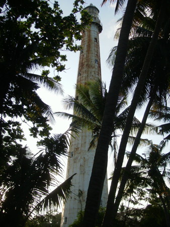
Pulau Sumedang Light, Java Sea, July 2012
photo copyright saripudin; permission requested
Belitung Lighthouses Belitung Regency (Gelasa Strait) Lighthouses
Pulau Sumedang (Pulau Simedang, Shoalwater Island)
1883. Active; focal plane 61 m (200 ft); two white flashes every 20 s. 57 m (187 ft) 16-sided cast iron tower with lantern and gallery, painted white. Several 1-story coast guard buildings. A 2012 photo is above right, Suratman Trautman also has a view from the sea and Bing has a good satellite view of the station. This lighthouse is in the Java Sea about 80 km (50 mi) southeast of Bangka and 50 km (30 mi) southwest of Belitung. Site status unknown. ARLHS IDO-029; Admiralty Q1020; NGA 22972. Pulau Kasenga
Date unknown. Active; focal plane 20 m (66 ft); white flash every 5 s. 18 m (59 ft) round tower, painted with red and white horizontal bands and mounted on a square platform supported by piles. No photo available but Google has a distant satellite view. This light guides northbound vessels entering the Gelasa (Gaspar) Strait between Belitung and Bangka. Located off a small island southwest of the southwestern point of Belitung. Accessible only by boat. Site status unknown. ARLHS IDO-146; Admiralty Q1022; NGA 22980. Tanjung Ajer Lancur (Tanjung Ajer Lantjoer, Tanjung Ayerlancur, Pulau Mendanau)
1882. Active; focal plane 62 m (203 ft); three white flashes every 20 s. 27 m (89 ft) round (or 16-sided) cast iron tower with lantern and gallery, painted white. A photo is at right, a 2016 photo is available, Frey Jabink has a closeup photo, ARLHS has a photo of the top of the tower, and Google has a good satellite view of the station. Located at the western point of the island of Mendanau, off the west coast of Belitung. Site status unknown. ARLHS IDO-036; Admiralty Q1024; NGA 22976. Pulau Langir
Date unknown. Active; focal plane 22 m (72 ft); two white flashes every 15 s. Approx. 18 m (59 ft) white skeletal tower. No photo available but Google has an indistinct satellite view. The light guides ships approaching Tanjung Pandan. Located on a small island off the northwestern point of the island of Mendanau. Site status unknown. Admiralty Q1024.05; NGA 22976.5. * Tanjung Pandan Harbor
Date unknown. Active; focal plane 24 m (79 ft); white flash every 5 s. Approx. 22 m (72 ft) square skeletal tower with gallery, painted white. Google has a street view and a satellite view. Located on the waterfront of Tanjung Pandan, a port on the west side of Belitung and the capital of Belitung Regency. Site open, tower closed. ARLHS IDO-319; Admiralty Q1028.8; NGA 22998. 
Tanjung Ajer Lancur Light, Gelasa Strait, July 2016
Google Plus photo
Pulau Lengkuas (Langkuas)
1883. Active; focal plane 61 m (200 ft); white flash every 7.5 s. 57 m (187 ft) 16-sided cast iron tower, painted white with lantern and gallery. Hanif's photo is at right, a closeup photo is available, Bimo Pakusadewa has a 2016 street view, and Google has a satellite view of the station. This lighthouse is just off the northern point of Belitung, facing the Karimata Strait, which joins the Natuna Sea to the Java Sea between Sumatra and Kalimantan (Borneo). It was prefabricated by Enthoven at The Hague. Site status unknown. ARLHS IDO-010; Admiralty Q1030; NGA 22984.
East Belitung Regency (Karimata Strait) Lighthouses Pulau Kanis (Pulau Pekandis)
Date unknown. Active; focal plane 12 m (39 ft); two white flashes every 8 s. 10 m (33 ft) white square skeletal tower. No photo available and the tower is not seen in Bing's satellite view of the island. NGA lists the light as "Northeast Coast." Located on a small island off the northeast coast of Belitung. Accessible only by boat. Site open, tower closed. Admiralty Q1032; NGA 22988. Pulau Pesemut
Date unknown. Active; focal plane 43 m (141 ft); one long white flash every 5 s. 40 m (131 ft) tapered square skeletal tower with gallery, painted white. Four 1-story coast guard buildings. A photo (slow-loading), a small photo and another small photo are available, and Bing has a satellite view of the station. This lighthouse marks the end of a long reef extending eastward from Belitung; it is of crucial importance for vessels in the Karimata Strait. Located on a low island in the strait about 65 km (40 mi) northeast of Belitung. Accessible only by boat. Site status unknown. ARLHS IDO-240; Admiralty Q1033; NGA 25056. 
Pulau Lengkuas Light, Belitung, October 2008
Flickr photo copyright Hanif; used by permission
Manggar
Date unknown. Active; focal plane 22 m (72 ft); white flash every 5 s. Approx. 19 m (62 ft) square skeletal tower, painted white. The lighthouse appears in Eriko Utama's street view and Google has a satellite view. Located on the north side of Manggar, the capital of the East Belitung Regency. Site status unknown. Admiralty Q1032.5; NGA 22990.
Information available on lost lighthouses:
Notable faux lighthouses:
Lighthouses of Indonesia: Natuna Sea (Tudjuh) Islands
Indonesia has been independent since 1945 after having been the Dutch East Indies for more than 350 years. It is a huge country, stretching along both sides of the Equator for more than 46 degrees of longitude (roughly 5100 km or 3200 miles). Comprised of some 17,000 islands (more than 6000 inhabited islands), it has hundreds of major aids to navigation. Information about them is scarce and photos are even scarcer. Official light lists contain dozens of entries for "framework towers" and "white beacons," providing little guidance for the lighthouse fan. We need more information and photos; if you know about lighthouses in Indonesia, please share that knowledge.
Indonesia's Riau Islands Province includes four groups of small islands located between Sumatra and Kalimantan (Borneo). The Riau group is south of Singapore and off the east coast of Sumatra; the Lingga group is farther south, straddling the Equator in the Karimata Strait; the Anambas group is off the east coast of West Malaysia; and the Natuna group is northwest of Sarawak in East Malaysia. In all there are more than 3000 islands in the province. This page lists lighthouses of the Anambas and Natuna Islands, known collectively in Indonesia as the Tudjuh Islands. The southern extension of the South China Sea surrounding these islands and extending south between Malaya and Borneo is now called the Natuna Sea, a name recognized by the International Hydrographic Organization in 1986.
The Indonesian word for a lighthouse is mercusuar. The phrase menara suar, which includes the Arabic word menara, is sometimes used instead. Tanjung and ujung are words for capes, pulau is an island, selat is a strait, teluk is a bay or harbor, and pelabuhan or labuan is a port.
Aids to navigation in Indonesia are operated and maintained by the Directorate General of Sea Navigation.
ARLHS numbers are from the ARLHS World List of Lights. Admiralty numbers are from volume F of the Admiralty List of Lights & Fog Signals. U.S. NGA List numbers are from Publication 112. General Sources
Garis Depan Nusantara - Kepulauan Riau
This site, no longer online, was the source for several of the photos on this page. The Indonesian name means "frontier archipelago," and the site concentrated on remote islands where Indonesian sovereignty might be in question. World of Lighthouses - Indonesia
Photos by various photographers available from Lightphotos.net Indonesian Lighthouses
Historic postcard views from the collection of Michel Forand. Online List of Lights - Indonesia - Volume F
Coming soon: photos by various photographers posted by Alexander Trabas. GPSNavigationCharts
Navigation chart information for the Natuna Sea. 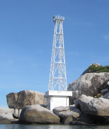
Pulau Tokong Nanas Light, Anambas Islands, June 2013
ex-Panoramio photo copyright Taufik Hidayatullah; used by permission
Anambas Islands Regency Lighthouses Note: The Anambas Islands are an archipelago in the Natuna Sea about 250-350 km (160-220 mi) northeast of the Malayan coast. The largest islands in the group are Jemaja in the southwest and a group of islands in the north that includes Mubur, Matak, and Siantan. The islands have a population of about 37,500 and are governed as a regency of Riau Islands Province.
Southwestern Islands (Pulau Jemaja Area) Lighthouses
Pulau Malang Biru (Tokong Malangbiru) (2?)
Date unknown. Active (?); focal plane 16 m (52 ft); white flash every 4 s. NGA describes the current light only as a "white beacon." The original (?) lighthouse here was a tapered octagonal concrete or masonry tower with gallery. The upper half was painted white and the lower half black. Xinlu Liu has a 2018 view from the sea (also seen at right), a closer photo and another view from the sea are available, and Bing has an indistinct satellite view. This lighthouse would have had a focal plane of at least 40 m (131 ft). In the photos the lighthouse appears abandoned but there is no sign of a more recent light. Malang Biru, the southernmost island of the Anambas group, is an isolated rock about 65 km (40 mi) south southwest of the main Anambas group and 175 km (110 mi) northeast of Singapore Strait. Accessible only by boat. Site status unknown. Admiralty F1831; NGA 21097.5. Pulau Repong
Date unknown. Active; focal plane 22 m (72 ft); four white flashes every 12 s. Described only as a "white beacon." No photo available and the light is not seen in Bing's satellite view of the island. Located on the northwest side of a small island about 50 km (30 mi) south of the main Anambas group. Accessible only by boat. Site status unknown. Admiralty F1830.8; NGA 21097.6. Pulau Damar
Date unknown. Active; focal plane 88 m (289 ft); white flash every 3 s. 10 m (33 ft) white fiberglass tower. No photo available and the lighthouse is not seen in Bing's satellite view. Pulau Damar is the westernmost island of the Anambas group and is an important landmark for vessels bound to or from Singapore. The light has a listed range of 40 km (25 mi). Located on a small island about 30 km (19 mi) west southwest of Pulau Jemaja. Accessible only by boat. Site status unknown. Admiralty F1828; NGA 21097. 
Tokong Malingburu Light, Anambas Islands, June 2018
Google Maps photo by Xinlu Liu
Pulau Mangkai
Date unknown. Active; focal plane 196 m (343 ft); three white flashes every 15 s. 40 m (131 ft) square iron skeletal tower with lantern and gallery, painted white. At least three 1-story Coast Guard station buildings. No photo available but Bing has a good satellite view of the station. Mangkal is a mountainous island about 6 km (3.5 mi) in length located off the northwestern tip of Pulau Jemaja. Located on the highest point of the island. Site status unknown. Admiralty F1832; NGA 21096. Pulau Tulai
Date unknown. Active; focal plane 25 m (82 ft); white flash every 6 s. Approx. 15 m (49 ft) white tower. No photo available but Bing has a distant satellite view. Located on a small island off Letung, the principal town of Pulau Jemaja. Accessible only by boat. Admiralty F1830.5; NGA 21096.7. Letung (Letong)
Date unknown. Active; focal plane 60 m (197 ft); white flash every 6 s. 10 m (33 ft) white fiberglass tower. No photo available and the lighthouse has not been found in Bing's satellite view. Letung is the principal town of Pulau Jemaja, located on the northwest side of the island. Located on heights above the town. Site status unknown. Admiralty F1830; NGA 21096.5. Tanjung Lelan
Date unknown. Active; focal plane 40 m (131 ft); two white flashes every 10 s. No description in NGA, but this is probably a 40 m (131 ft) skeletal tower. No photo available and the tower has not been located in Bing's satellite view of the cape. Located at the southern tip of Pulau Jemaja. Accessible only by boat. Admiralty F1830.55; NGA 21096.8.
Northeastern Islands (Pulau Siantan Area) Lighthouses
Pulau Tokong Nanas
2006. Active; focal plane 40 m (131 ft); two white flashes every 10 s. 30 m (98 ft) square skeletal tower with gallery, mounted on a square concrete equipment shelter. Lighthouse painted white. Taufik Hidayatullah's photo is at the top of this page but the tower is not shown in Bing's satellite view. Located on a rocky reef about 25 km (15 mi) northwest of Tanjung Pedas. Accessible only by boat. Site open, tower closed. Admiralty F1835.5. Tanjung Pedas
Date unknown. Active; focal plane 82 m (269 ft); white flash every 4 s. 40 m (131 ft) skeletal tower, painted white. At least five 1-story Coast Guard station buildings. No photo available but Bing has a satellite view of the station. This lighthouse guides vessels to Terempa, the principal town of the islands. Located at the northwestern tip of Siantan, one of the major islands of the Anambas group. Site status unknown. Admiralty F1835; NGA 21117. * Terempa
Date unknown. Active; focal plane 14 m (46 ft); continuous red light (?). 13 m (43 ft) round white concrete tower, flared at the top and bottom, mounted on a square platform supported by piles. Taufik Hidayatullah's photo is at right, Agregasi Haluan Kepri has a photo and Bing has an indistinct satellite view. In the photo the tower appears to have a white light. There is also a photo of a second light in Terempa. Located on the waterfront of Terempa, the principal town of the islands. Located on the north side of Siantan. Site open, tower closed. Admiralty F1836.3; NGA 21120. 
Terempa Light, Terempa, June 2013
photo copyright Taufik Hidayatullah; used by permission
Pulau Tokong Belayer
2006. Active; focal plane 40 m (131 ft); two white flashes every 10 s. 30 m (98 ft) square skeletal tower with gallery, mounted on a square concrete equipment shelter. Lighthouse painted white. A photo is at right, a 2009 photo is available, and Google has a satellite view. Located on a rocky reef at the northern tip of the Anambas archipelago. Accessible only by boat. Site open, tower closed. Admiralty F1835.8.
Southeastern Islands (Pulau Airabu Area) Lighthouses Pulau Nunsa
Date unknown. Active; focal plane 25 m (82 ft); four white flashes every 20 s. Approx. 15 m (49 ft) square skeletal tower, painted white. No photo available but Google has a satellite view. Located at the south end of a small island at the southeastern end of an archipelago stretching southeastward from the major island of Siantan. Accessible only by boat. Site open, tower closed. Admiralty F1834; NGA 21097.8. Pulau Serak
Date unknown. Active; focal plane 22 m (72 ft); four white flashes every 20 s. Approx. 12 m (39 ft) square skeletal tower, painted white. No photo available, but Google has a satellite view. Located on the west side of a small island about halfway between the major islands of Jemaja and Airabu. Accessible only by boat. Site open, tower closed. Admiralty F1830.6; NGA 21097.7. 
Pulau Tokong Belayer Light, Anambas Islands
anonymous Creative Commons photo posted by Garis Depan Nusantara
Pulau Ritan
Date unknown. Active; focal plane 17 m (56 ft); white flash every 6 s. 17 m (56 ft) white skeletal (?) tower mounted on a platform supported by piles. No photo available but Google has an indistinct satellite view. Located on a reef off Pulau Ritan, a small island at the southeastern corner of the Anambas Islands. Accessible only by boat. Site open, tower closed. Admiralty F1830.7; NGA 21097.65.
Natuna Regency Lighthouses Note: The Natuna Islands are located in the Natuna Sea about 325 km (200 mi) off the coast of Borneo. Natuna Besar (Great Natuna Island) is by far the largest island of the group. The islands have a population of about 70,000. The Natuna Regency also includes the Tambelan and Badas Islands, two groups farther south in the Natuna Sea.
North Natuna Islands (Pulau Laut Area) Lighthouses
Pulau Sekatung (Sekatoeng, Tanjung Pala)
Date unknown. Active; focal plane 98 m (322 ft); white light occulting once every 3 s. 30 m (98 ft) skeletal tower with gallery, painted white. Several 1-story keeper's houses or other station buildings. A photo is at right, Dedi Yudia has a distant view, and Bing has a satellite view of the station. This light marks the northernmost point of the Natuna group; it is Indonesia's northernmost light in the South China Sea. Located on a small island off the northeastern tip of Pulau Laut ("Sea Island"), about 120 km (75 mi) north of Natuna Besar (Great Natuna). Accessible only by boat. Site status unknown. Admiralty F1836.5; NGA 21112. Pulau Sebetul (Sekapul)
2006. Active; focal plane 34 m (112 ft); two white flashes every 10 s. 30 m (98 ft) square skeletal tower with gallery, mounted on a square concrete equipment building. A photo is available (#3 on the page) and Bing has a satellite view. Located on a rocky reef off the southwestern tip of Pulau Laut. Accessible only by boat. Site open, tower closed. Admiralty F1836.55. Pulau Semiun (Semium)
Date unknown. Active; focal plane 160 m (525 ft); white flash every 5 s. Approx. 40 m (131 ft) square skeletal tower with gallery, painted white. Numerous station buildings. A view from the sea is available, and Bing has a satellite view of the station. Located atop a small high island 40 km (25 mi) southwest of Pulau Laut and about 80 km (50 mi) northwest of the northern point of Natuna Besar. Accessible only by boat. Site status unknown. Admiralty F1836.6; NGA 21114. 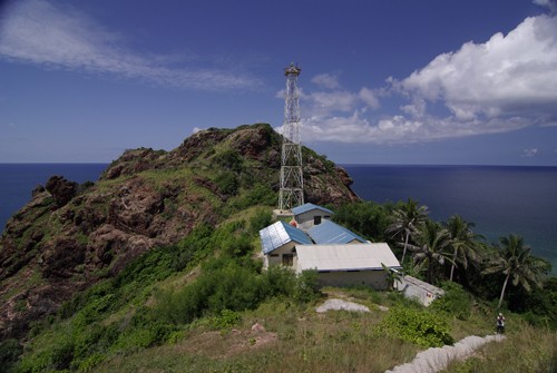
Sekatung Light, Natuna Islands, September 2008
Creative Commons photo by Deni Sambas posted by Garis Depan Nusantara
Middle Natuna Islands (Pulau Natuna Besar Area) Lighthouses
Pulau Tokong Boro (Tokongboro)
2006. Active; focal plane 34 m (112 ft); two white flashes every 10 s. 30 m (98 ft) square skeletal tower with gallery, mounted on a square concrete equipment shelter. Lighthouse painted white. A photo is at right and another photo is available (#1 on the page), but the island is barely visible in Google's satellite view. Located on a rocky reef about 55 km (35 mi) west of Natuna Besar. Accessible only by boat. Site open, tower closed. Admiralty F1836.9. Pulau Seluan (Saluan)
Date unknown. Active; focal plane 38 m (125 ft); four white flashes every 15 s. Approx. 15 m (49 ft) square skeletal tower, painted white. No photo available but Google has a satellite view. Located at the south end of Seluan, an island about 18 km (11 mi) west of Natuna Besar. Site status unknown. Admiralty F1836.8; NGA 21101. Pulau Senua (Senoa)
2006. Active; focal plane about 46 m (151 ft); two white flashes every 10 s. 30 m (98 ft) square skeletal tower with gallery, painted white, rising from a large square station building. A 2018 photo, another photo and a distant view from the sea are available, and Google has a satellite view. Located on an island about 7 km (4 mi) north northeast of Tanjung Senubing, off the east coast of Natuna Besar. Site status unknown. Admiralty F1836.65. Tanjung Sinumbing (Senubing, Senoebing)
Date unknown. Active; focal plane 106 m (348 ft); white flash every 10 s. 20 m (66 ft) square skeletal tower with gallery, painted white. Several large station buildings. Part of the tower is seen in Jimmy Syahrasyid's photo of the station entrance, Bayuseta Jati has a view from the gallery and Google has a satellite view of the station. Located on heights at the easternmost point of Natuna Besar. Site open, and apparently the tower can be climbed. Admiralty F1836.7; NGA 21108. Karang Setahi (Pulau Setahi, Pulau Setai)
Date unknown. Active; focal plane 13 m (43 ft); white flash every 4 s. 13 m (43 ft) barbell-shaped white fiberglass tower mounted on a square platform supported by piles. No photo available but Google has a satellite view. This light marks the southern entrance to the Lampa Strait, a narrow passage around the southwestern end of Pulau Natuna Besar that leads to principal port of Sedanau. Located just off the northeastern coast of Pulau Setahi. Accessible only by boat. Site open, tower closed. Admiralty F1837.8; NGA 21106. Karang Sedanau
Date unknown. Active; focal plane 15 m (49 ft); white flash every 4 s. 15 m (49 ft) white fiberglass (?) tower on a square platform supported by piles. No photo available but Google has a satellite view. Located on a reef south of Pulau Sedanau off the southwest coast of Natuna Besar. Accessible only by boat. Site open, tower closed. Admiralty F1837.6; NGA 21104. 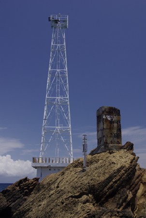
Tokong Boro Light, Natuna Islands, September 2008
anonymous Creative Commons photo
posted by Garis Depan Nusantara
South Natuna Islands (Pulau Midai, Subi Islands, and Pulau Serasan Area) Lighthouses Pulau Midai
Date unknown. Active; focal plane 158 m (518 ft); white flash every 20 s. 30 m (98 ft) square pyramidal skeletal tower, painted white. No photo available but Google has a satellite view of the station. Pulau Midai is an isolated high island in the South Natuna group about 130 km (80 mi) southwest of Natuna Besar. Located on the highest point of the island. Site status unknown. Admiralty F1838; NGA 21100. Pelabuhan Pulau Midai
Date unknown. Active; focal plane about 11 m (36 ft); three white flashes every 10 s. Approx. 11 m (36 ft) square white skeletal tower with gallery. Guntur Yudha Prawira has a distant photo and Google has a fuzzy satellite view. Located on the pier at the Pulau Midai settlement, on the northwestern tip of the island. Site open, tower closed. Admiralty F1838.3; NGA 21098. Karang Jackson
Date unknown. Active; focal plane 15 m (49 ft); white flash every 5 s. 15 m (49 ft) square skeletal tower mounted on a square platform supported by piles. Lighthouse painted red, not white as listed by NGA. Sayuti Malik has a photo (fourth photo on the page) and Google has a satellite view. Located just off the southeastern tip of Pulau Midai. Accessible only by boat. Site open, tower closed. Admiralty F1838.35; NGA 21100.1. Pulau Subi Kecil (Subi-kechil)
Date unknown (station established 1910). Active; focal plane 83 m (272 ft); three white flashes every 15 s. 22 m (72 ft) skeletal tower, painted white. Four coast guard station buildings. No photo available but Google has a satellite view of the station. Pulau Subi Kecil is a small island in the South Natuna group, just north of Subi Besar and about 130 km (80 mi) southeast of Natuna Besar. Located on the highest point of the island. Site status unknown. ARLHS IDO-182; Admiralty F1844; NGA 25108. Pulau Seraya (Seraja)
Date unknown. Active; focal plane 97 m (318 ft); white flash every 6 s. Approx. 40 m (131 ft) tapered square skeletal tower with lantern and gallery. Lighthouse painted white. Several 1-story Coast Guard station buildings. No photo available but Bing has a satellite view of the station. Located on a promontory on the west coast of Pulau Seraya, an island about 30 km (19 mi) southwest of Pulau Subi Besar. Site status unknown. Admiralty F1845; NGA 25107. Pulau Kelapa
2006. Active; focal plane 51 m (167 ft); two white flashes every 10 s. 40 m (131 ft) square skeletal tower with gallery, mounted on a 2-story concrete keeper's house. Entire lighthouse painted white. The station is staffed by 3 keepers. No photo available but Bing has a satellite view. Located on Pulau Kepala (Coconut Island), a small island off the northeastern end of Pulau Serasan, about 160 km (100 mi) southeast of Natuna Besar. Site status unknown. Admiralty F1846. Pulau Serasan
Date unknown. Active; focal plane 12.5 m (41 ft); green flash every 3 s (?). Approx. 12.5 m (41 ft) square skeletal tower with gallery, painted red and mounted on a square platform supported by piles. No photo available but Google has a satellite view. This light and the Batu Pacil light (next entry) frame the entrance to a narrow passage leading to the port of Serasan. Located on a reef off the southwestern end of Pulau Serasan. Accessible only by boat. Site open, tower closed. Admiralty F1847.5. Batu Pacil
Date unknown. Active; focal plane 12.5 m (41 ft); red flash every 3 s. 12.5 m (41 ft) square skeletal tower with gallery, painted red and mounted on a square platform supported by piles. No photo available but Google has a satellite view. Located on a reef off the southwestern end of Pulau Serasan. Accessible only by boat. Site open, tower closed. Admiralty F1848; NGA 25106. Pulau Merendam (Merundung)
Date unknown. Active; focal plane 37 m (121 ft); three white flashes every 15 s. 30 m (98 ft) skeletal tower, painted white. Several coast guard station buildings. No photo available but Bing has a satellite view of the station. Located on a small island about 30 km (19 mi) northwest of the Kalimantan coast and about 60 km (38 mi) west of Tanjung Datu, Sarawak. Accessible only by boat. Site status unknown. ARLHS IDO-012; Admiralty F1850; NGA 25100. Pulau Murih (Muri Island)
Date unknown (station established 1901). Active; focal plane 102 m (335 ft); white flash every 6 s. 20 m (66 ft) skeletal tower, painted white. Several coast guard station buildings. No photo available but Bing has an indistinct satellite view of the station. Located on the westernmost of two small islands about 70 km (45 mi) northwest of the Kalimantan coast and about 50 km (30 mi) southwest of Pulau Merendam. Accessible only by boat. Site status unknown. ARLHS IDO-228; Admiralty F1854; NGA 25096.
Tambelan Islands and Badas Islands Lighthouses Note: The Tambelan Islands and Badas Islands are located about 250 km (150 mi) southwest of the Natuna Islands; this places them off the southwest coast of Kalimantan (Borneo) at the northern entrance to the Karimata Strait.
Tambelan (Pulau Tambelan Besar)
Date unknown. Active; focal plane 12 m (39 ft); white flash every 3 s. 12 m (39 ft) white skeletal tower mounted on a square platform supported by piles. No photo available but Google has an indistinct satellite view. Located on a reef at the entrance to the sheltered harbor of Pulau Tambelan Besar, the largest settlement in the islands. Accessible only by boat. Site open, tower closed. Admiralty F1887; NGA 25086. Pulau Dumdum
Date unknown. Active; focal plane 15 m (49 ft); white flash every 3 s. 12 m (39 ft) white "beacon," probably a skeletal tower. No photo available; Bing has an indistinct satellite view that probably shows the lighthouse. Located on a small, uninhabited island at the northwestern edge of the Tambelan Islands. Accessible only by boat. Site status unknown. Admiralty F1889; NGA 25086.5. Pulau Tokong Kemudi (Tokongkemudi)
Date unknown (recent). Active; focal plane 130 m (427 ft); white flash every 5 s. Described by NGA only as a white beacon. No photo available but the light is is probably seen in Bing's fuzzy satellite view. Located on a remote island at the western edge of the Tambelan Islands. Accessible only by boat. Site status unknown. Admiralty F1888.5; NGA 25086.4. Pulau Jengkulan (Jangkulan)
Date unknown. Active; focal plane 15 m (49 ft); three white flashes every 15 s. 10 m (33 ft) white fiberglass tower. No photo available and Bing has only a fuzzy satellite view of the station. Located on a small, uninhabited island about 30 km (19 mi) southwest of Pulau Tambelan Besar. Accessible only by boat. Site status unknown. Admiralty F1888; NGA 25086.3. Pulau Anakaur
Date unknown. Active; focal plane unknown; two white flashes every 5 s. Approx. 20 m (66 ft) square white skeletal tower. No photo available but Bing has a satellite view. Located on the northwestern tip of Pulau Anakaur, the westernmost of the Badas Islands, about 65 km (40 mi) southwest of Pulau Tambelan Besar. Accessible only by boat. Site status unknown. Admiralty F1888.2. Pulau Pejantan (Penjantan)
Date unknown. Active; focal plane 106 m (348 ft); white flash every 6 s. 40 m (131 ft) tapered square skeletal tower painted white. Arief Setiawan's photo is at right and Bing has a good satellite view. Located on an isolated island of the Badas group, about 100 km (60 mi) south of Pulau Tambelan Besar. Accessible only by boat. Site status unknown. Admiralty F1888.4. 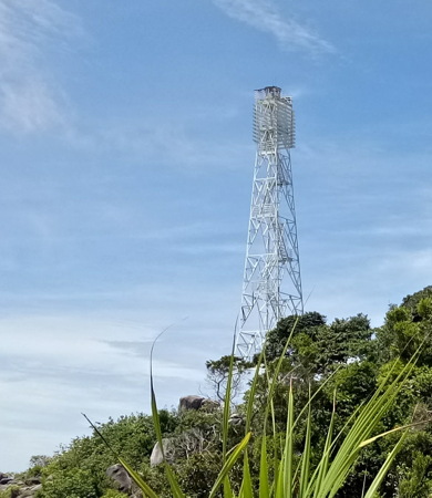
Pulau Pejantan Light, Badas Islands, August 2017
ex-Google Plus photo by Arief Setiawan
Information available on lost lighthouses:
Notable faux lighthouses:
Lighthouses of Indonesia: Riau Islands
Indonesia has been independent since 1945 after having been the Dutch East Indies for more than 350 years. It is a huge country, stretching along both sides of the Equator for more than 46 degrees of longitude (roughly 5100 km or 3200 miles). Comprised of some 17,000 islands (more than 6000 inhabited islands), it has hundreds of major aids to navigation. Unfortunately, it's difficult to know how many of these aids can be considered lighthouses. Information about them is scarce, and photos are even scarcer. Official light lists contain dozens of entries for "framework towers" and "white beacons," providing little guidance for the lighthouse fan.
Indonesia's Riau Islands Province includes four groups of small islands located between Sumatra and Kalimantan (Borneo). Formerly considered to be a southern extension of the South China Sea, these waters are now known as the Natuna Sea. The Riau group is south of Singapore and off the east coast of Sumatra; the Lingga group is farther south, straddling the Equator in the Karimata Strait; the Anambas group is in the Natuna Sea off the east coast of West Malaysia; and the Natuna group is also in the Natuna Sea northwest of Sarawak in East Malaysia. In all there are more than 3000 islands in the province. This page includes lighthouses of the Riau and Lingga groups; the Natuna Sea Islands page includes the lighthouses of the Anambas and Natuna Islands.
The Indonesian word for a lighthouse is mercusuar. The phrase menara suar, which includes the Arabic word menara, is sometimes used instead. Tanjung and ujung are words for capes, pulau is an island, selat is a strait, teluk is a bay or harbor, and pelabuhan or labuan is a port.
Aids to navigation in Indonesia are operated and maintained by the Directorate General of Sea Navigation.
ARLHS numbers are from the ARLHS World List of Lights. Admiralty numbers are from volumes F and K of the Admiralty List of Lights & Fog Signals. U.S. NGA List numbers are from Publication 112. General Sources World of Lighthouses - Indonesia
Photos by various photographers available from Lightphotos.net. Indonesian Lighthouses
Historic postcard views from the collection of Michel Forand. Online List of Lights - Indonesia - Volume F and Volume Q
Photos by various photographers posted by Alexander Trabas. Maps Online - Riau Islands
A useful map showing the regency boundaries. GPSNavigationCharts
Navigation chart information for the Riau Islands. 
Takong Kecil Light, Singapore Strait, undated
Small Islands Directorate (no longer online)
Karimun Regency (Western Riau Islands) Lighthouses Across the Singapore Strait from Singapore the Riau Islands proper are a loose group lying off the east coast of Sumatra. The islands are divided into three groups: Karimun in the west, Batam in the center, and Bintan in the east. The Durian Strait separates Karimun from Batam, and the Riau Strait separates Batam from Bintan.
Malacca Strait Lighthouses Pulau Iyu Kecil (The Brothers) (2)
Date unknown (station established 1906). Active; focal plane 41 m (135 ft); three white flashes every 15 s. 13 m (43 ft) round concrete tower with lantern and gallery. Lighthouse painted white. Wikimapia has a photo by Max von Schtirlitz, a view from the sea is available, Lightphotos.net also has a view from the sea, and Google has a satellite view. NGA lists a skeletal tower at this location. The Brothers are two small islands (Iyu Kecil and Iyu Besar) at the southern end of the Malacca Strait. Vessels eastbound in the Malacca Strait pass between this important light and Malaysia's Tanjung Piai Light shortly before turning into the Singapore Strait. Located on an island at the western entrance to the Singapore Strait, about 8 km (5 mi) north of the northern tip of Pulau Karimun. Accessible only by boat. Site status unknown. ARLHS IDO-072; Admiralty F1674; NGA 22584. Pulau Karimun Kecil (Little Karimun Island)
2007. Active; focal plane 18 m (59 ft); white flash every 5 s. 15 m (49 ft) square pyramidal white skeletal tower. No photo available, but Google has a satellite view. Located on the northern tip of Little Karimun, about 5 km (3 mi) southeast of The Brothers. Accessible only by boat. Site status unknown. Admiralty F1674.05; NGA 22581.
Pulau Karimun Besar and Pulau Kundur Area Lighthouses The Durian Strait (Selat Durian) is a north-south passage through the Riau Islands beginning at the western end of the Singapore Strait. Pulau Karimun Besar and Pulau Kundur are large islands west of the Durian Strait, separated from the mainland of Sumatra by another strait.
Sebatak Shoal
Date unknown. Active; focal plane 12 m (39 ft); two white flashes every 5 s. 12 m (39 ft) round fiberglass tower colored black with a red horizontal band and mounted on a platform supported by piles. No photo available but Bing has a satellite view. This light is listed by the Admiralty as "Karimun River" and by NGA as "Tangjung Sebatak Southeast." Located on a shoal in the northern entrance to the Durian Strait from the Singapore Strait, east of Pulau Karimun Besar. Accessible only by boat. Site status unknown. Admiralty F1417.6; NGA 22587. Tanjung Rambut
Date unknown. Active; focal plane 41 m (135 ft); three white flashes every 22 s. 40 m (131 ft) square skeletal tower with lantern and gallery, painted white; lantern painted red. A portion of Hendra Gunawan's aerial photo is at right and Google has a satellite view. This lighthouse is located near the city of Tanjungbalai on Great Karimun (Karimun Besar), an island at the southwestern end of Singapore Strait. The tower is part of a Maritime Security Agency (Badan Keamanan Laut) station monitoring ship traffic in the arra. Located on the southeastern tip of the island; there should be a good view from fast ferries connecting Tanjungbalai with Singapore. Site status unknown. ARLHS IDO-323; Admiralty F1417.5; NGA 22588. Pulau Babi
Date unknown. Active; focal plane 14 m (46 ft); white flash every 5 s. 14 m (46 ft) white tower mounted on a platform supported by piles. No photo available but Google has a satellite view. Located off the southern tip of an island at the west end of the narrow passage between Pulau Karimun Besar and Pulau Kundur. Accessible only by boat. Site open, tower closed. Admiralty F1417.3; NGA 22585.5. Karang Melvill (Melvill Reef)
Date unknown. Active; focal plane 11 m (36 ft); white flash every 5 s. 11 m (36 ft) square pyramidal white skeletal tower mounted on a square platform supported by piles. No photo available but Bing has a satellite view. Located on a reef on the east side of the strait near Pulau Mantaras Besar. Accessible only by boat. Site open, tower closed. Admiralty F1418; NGA 22596. Karang Tengah (Middleburg Reef)
Date unknown. Active; focal plane 11 m (36 ft); white light, 2 s on, 6 s off. 11 m (36 ft) square pyramidal white skeletal tower mounted on a square platform supported by piles. No photo available but Bing has a satellite view. Located on a reef on the west side of the Durian Strait southeast of Pulau Karimun Besar. Accessible only by boat. Site open, tower closed. Admiralty F1420; NGA 22600. 
Tanjung Rambut Light, Tanjungbalai, November 2017
ex-Google Plus photo by Hendra Gunawan
Pulau Pelangkat
Date unknown. Active; focal plane 13 m (43 ft); white light, 2 s on, 6 s off. 13 m (43 ft) square pyramidal white skeletal tower mounted on a square platform supported by piles. No photo available but Bing has a satellite view. Located on a reef on the west side of the Durian Strait just off the small island of Pulau Pelangkat. Accessible only by boat. Site open, tower closed. Admiralty F1422; NGA 22608. Tanjung Lubuh (Lubuk)
Date unknown. Active; focal plane 35 m (115 ft); white flash every 8 s. Approx. 30 m (98 ft) square skeletal tower with gallery. Photos (near the bottom of the page) are available, although the caption bekas mercusuar means "former lighthouse." Bing has a distant satellite view. Located on the southwestern tip of Pulau Kundur. Site open, tower closed. Admiralty F1417.2; NGA 22602.
Rukan Islands Lighthouse The Rukan (Brother) Islands are three small islands in the Natuna Sea south of the southern entrance to the Durian Strait. Rukan Utara (North Brother Island)
Date unknown. Active; focal plane 30 m (98 ft); white flash every 4 s. 13 m (43 ft) white skeletal tower. No photo available but Bing has a satellite view. Located on an islet about 10 km (6 mi) north of the better-known South Brother Island lighthouse (next entry). Accessible only by boat. Site status unknown. Admiralty F1426; NGA 22610. Rukan Selatan (South Brother Island, Zuid-Broeder)
1911. Active; focal plane 70 m (230 ft); white flash every 5 s. 22 m (72 ft) hexagonal skeletal tower with lantern and gallery, painted white. Several Coast Guard station buildings. No current photo available but Bing has a satellite view of the station. Forand has a historic postcard view. This light guides vessels northbound toward Singapore as they approach the Riau Islands. Located on a small island at the southern edge of the Riau group, about 20 km (13 mi) east of Tanjungkilang. Accessible only by boat. Site status unknown. ARLHS IDO-266; Admiralty F1428; NGA 22612.
Batam City (Central Riau Islands) Lighthouses Batam is a large island west of Pulau Bintan and directly opposite Singapore city. Batam has a population of more than one million; it is by far the largest city of the Riau Islands Province.
East Side Durian Strait Lighthouse
Pulau Jangkat
Date unknown. Active; focal plane 37 m (121 ft); white flash every 5 s. 30 m (98 ft) tapered octagonal aluminum tower with double gallery. Entire lighthouse is white. A portion of Willyarto Muhardani's aerial photo is at right and Google has a satellite view. A sibling of the Takong Kecil Light (see above). Located on an islet about 25 km (15 mi) east of Tanjung Rambut. Accessible only by boat. Site status unknown. Admiralty F1694.6; NGA 22592.
Singapore Strait Lighthouses North Nipa (Nipa Reef)
Date unknown. Active; focal plane 12 m (39 ft); 12 m (39 ft) round cylindrical tower mounted on a platform supported by four piles. Upper half of the tower painted black, lower half yellow. Trabas has Douglas Cameron's distant view and Bing has an indistinct satellite view. In the Straits traffic separation scheme westbound vessels pass just to the north of this light (the black over yellow daymark is international code for "stay to the north"). Located about 2 km (1.25 mi) north of the Nipe Reef light (next entry). Accessible only by boat. Site open, tower closed. Admiralty F1691.8; NGA 21491. Pulau Nipa (Nipa Reef, Nipah Reef) (2)
Date unknown (station established 1912). Active; focal plane 16 m (52 ft); white flash every 3 s. 16 m (52 ft) round tower with gallery, mounted on an octagonal concrete pier. Lighthouse painted white. Aziz Banjar has a closeup photo, Feybe Lumanauw also has a closeup photo, Trabas has Jim Smith's view from the sea, and Google has a satellite view. The original light had a focal plane of 11 m (36 ft). In the Straits traffic separation scheme westbound vessels pass just to the north of this light. Located on a dangerous reef about 10 km (6 mi) west of Singapore's famous Raffles Lighthouse. Accessible only by boat. Site open, tower closed. Admiralty F1692; NGA 21492. Pulau Pelampong
Date unknown. Active; focal plane 18 m (56 ft); white flash every 4 s. 15 m (49 ft) "white beacon." The lighthouse is seen at the start of a Youtube video, and Google has a satellite view. Located at the north end of a reef about 5 km (3 mi) east southeast of Nipa Reef. Accessible only by boat. Site open, tower closed. Admiralty F1693.95; NGA 21487. 
Pulau Jangkat Light, Durian Strait, November 2017
ex-Google Plus photo by Willyarto Muhardani
Pulau Cula
Date unknown. Active; focal plane 16 m (52 ft); three white flashes every 15 s. 15 m (49 ft) white skeletal tower. No photo available but Google has a satellite view. Eastbound vessels in the strait make a turn to the east as they approach the light. Located about 8 km (5 mi) south southwest of Takong Kecil (next entry). Accessible only by boat. Site and tower closed. Admiralty F1693.9; NGA 21495. Takong Kecil (Pulau Takong Kecil) (2)
Date unknown (station established 1910). Active; focal plane 48 m (157 ft); two flashes every 10 s, white or red depending on direction. 30 m (98 ft) tapered octagonal aluminum tower. Entire lighthouse is white. A photo is at the top of this page, Trabas has Rainer Arndt's photo, Ririn Ambar has a 2013 view, Wikipedia has a distant view, and Bing has a satellite view. The present lighthouse was apparently built sometime shortly after World War II. It was rebuilt in 1998 and its height may have been increased at that time. Eastbound vessels in the strait pass just to the south of the lighthouse. Located on a small island in the strait about 7 km (4.5 mi) southwest of Singapore's famous Raffles Lighthouse. Accessible only by boat. Site and tower closed. Admiralty F1694; NGA 21480.
Helen Mar Reef
Date unknown. Active; focal plane 16 m (52 ft); white flash every 6 s. 16 m (52 ft) round cylindrical concrete tower mounted on a square concrete pier. Upper half of the tower painted black, lower half yellow. Bing has a satellite view. Eastbound vessels in the strait pass just to the north of the lighthouse. Located on a reef about 2.5 km (1.5 mi) northwest of Pemping Besar. Accessible only by boat. Site open, tower closed. Admiralty F1694.7; NGA 21476. Karang Banteng (Buffalo Reef)
Date unknown. Active; focal plane 16 m (52 ft); quick-flashing white light. 16 m (52 ft) concrete tower with gallery. Upper half of the tower painted black, lower half yellow. No photo available but Google has a satellite view. Eastbound vessels in the strait pass just to the north of the lighthouse. Located on a reef about 12 km (7.5 mi) northeast of Pulau Takong Kecil. Accessible only by boat. Site open, tower closed. Admiralty F1695.6; NGA 21464. Batu Berhanti
Date unknown (station established 1910). Active; focal plane 16.5 m (54 ft); white flash every 8 s. 16.5 m (54 ft) round concrete tower with four wings, mounted on a square concrete pier. Jürgen Klinksiek's photo is at right, Trabas has Rainer Arndt's closeup photo, Lightphotos.net has a good photo, and Google has a satellite view. The original light had a focal plane of 12 m (39 ft). All vessels pass just to the north of the lighthouse. Located on a shoal in the center of Singapore Strait, about 10 km (6 mi) south of downtown Singapore. Accessible only by boat. Site and tower closed. Admiralty F1696; NGA 21400. 
Batu Berhanti Light, Singapore Strait, 2002
photo copyright Jürgen Klinksiek; used by permission
Batam Harbor Lighthouses Pulau Mariam
Date unknown. Active; focal plane 29 m (95 ft); green flash every 3 s. 8 m (26 ft) round white concrete tower. Winston Paiva has a distant view of the top of the tower and Google has an indistinct satellite view. NGA lists the light as "Mariaman." Located on a small island in the entrance to Batam harbor. Accessible only by boat. Site status unknown. Admiralty F1697.2; NGA 21412. Teluk Jodoh (Joduh, Batu Ampar)
Date unknown. Active; focal plane 20 m (66 ft); whute flash every 5 s. 20 m (66 ft) square white skeletal tower mounted on a platform supported by piles. Located on a reef just off the Batam waterfront. No photo available but Google has a satellite view. Located on a shoal off the entrance to Jodoh, an industrial port on the north coast of Pulau Batam. Accessible only by boat. Site open, tower closed. Admiralty F1697.965; NGA 21460.5.
Eastern Batam (Riau Strait) Lighthouses Pulau Nongsa (Pulau Putri)
1996. Active; focal plane 40 m (131 ft); white flash every 8 s. Approx. 37 m (121 ft) square skeletal tower with gallery, painted white. Disnav Tanjungpinang has an aerial photo and Bing has a satellite view. Pulau Nongsa and Pulau Putri are islets on the south side of the Singapore Strait about 30 km (19 mi) southeast of Singapore city. The lighthouse is actually on Pulau Putri. Accessible only by boat. Site and tower closed. ARLHS IDO-049; Admiralty F1697.99; NGA 21462. Batu Besar (2?)
Date unknown. Active; focal plane about 15 m (49 ft); white flash every 5 s. Approx. 11 m (36 ft) square white skeletal tower. No photo available but Google has a satellite view. Located on the quay at a new port being built at the northeastern corner of Pulau Batam and the west side of the northern entrance to the Riau Strait. Site status unknown. Admiralty F1772.1; NGA 22618. Karang Galang
Date unknown. Active; focal plane 13 m (43 ft); white flash every 6 s. 10 m (33 ft) metal tower painted with black and white horizontal bands. No photo available, but Google has a satellite view. Located at the northeast corner of a reef in the northern entrance to the Riau Strait. Accessible only by boat. Site open, tower closed. Admiralty F1772; NGA 22620. Kabil Range Front (?)
Date unknown. Active (?); focal plane 14 m (46 ft); white light, 1 s on, 1 s off. 12 m (39 ft) square cylindrical white skeletal tower. No photo available but Bing has a satellite view. However, the light is not seen in Google's satellite view, so it may have been removed or relocated. Located on a pier at Kabil. Site and tower closed. Admiralty F1772.3; NGA 22620.5. * Kabil Range Rear
Date unknown. Active; focal plane 30 m (98 ft); white light, 2 s on, 2 s off (?). Approx. 27 m (89 ft) square cylindrical white skeletal tower. Google has a street view and a satellite view. The range guides vessels to an oil terminal on the east coast of Batam. Located behind the port area at Kabil. It's possible this light is now configured as a leading light. Site and tower closed, but the lighthouse can be seen from a nearby road. Admiralty F1772.31; NGA 22620.6. Kabil South Range Front
Date unknown. Active (?); focal plane 15 m (49 ft); quick-flashing white light. 15 m (49 ft) square cylindrical white skeletal tower mounted on a square concrete pier supported by piles. No photo available but Bing has a satellite view. However, the light is not seen in Google's satellite view. The range guides southbound vessels in the Riau Strait. Located just off the east coast of Batam about 2.5 km (1.5 mi) south of Kabil. Accessible only by boat. Site open, tower closed. Admiralty F1772.4; NGA 22621. Kabil South Range Rear
Date unknown. Active; focal plane 23 m (75 ft); white light, 2 s on, 1 s off. 23 m (75 ft) square cylindrical white skeletal tower mounted on a square concrete pier supported by piles. No photo available but Bing has a satellite view. Located about 400 m (1/4 mi) south southwest of the front light. Accessible only by boat. Site open, tower closed. Admiralty F1772.41; NGA 22621.5.
* Punggur Harbor (Tanjung Kasem)
Date unknown. Active; focal plane 10 m (33 ft); white flash every 3 s. 10 m (33 ft) square white skeletal tower mounted on a platform supported by piles. A photo is at right and Google has a satellite view. Located at the ferry terminal on the south side of Batam. Site open, tower closed. Admiralty F1772.48; NGA 22620.8. Pulau Tanjungsau
Date unknown. Active; focal plane 34 m (112 ft); white flash every 5 s. 11 m (36 ft) white skeletal tower, apparently with lantern and gallery. No photo available but Google has a satellite view. Located on a headland projecting into the Riau Strait on the east side of Pulau Tanjungsau. Site status unknown. Admiralty F1774; NGA 22632. Pulau Tungjuk Range Rear
Date unknown. Active; focal plane 23 m (75 ft); white light, 2 s on, 1 s off. 20 m (66 ft) white skeletal tower. Coast guard station with several buildings. Bella Syafitri has a closeup 2018 photo and Google has a satellite view. The range guides vessels in a long channel southbound in the Riau Strait. Located on a small island off the southeastern coast of Pulau Batam. Accessible only by boat. Site status unknown. Admiralty F1780.1; NGA 22648. Pulau Karas Kecil
Date unknown. Active; focal plane 43 m (141 ft); white flash every 5 s. 11 m (36 ft) hexagonal white skeletal tower. Coast guard station with several buildings. Hanjaya Mandala has a 2018 closeup photo and Google has a satellite view of the station. Located at the eastern end of a small island in the southern entrance to the Riau Strait. Accessible only by boat. Site status unknown. Admiralty F1802; NGA 22676. 
Punggur Harbor Light, Batam, February 2015
ex-Panoramio Creative Commons photo by agungsty
Bintan Regency (Eastern Riau Islands) Lighthouses East Coast (Natuna Sea) Lighthouses Pulau Bintan (Bintan Island), the largest of the Riau Islands, lies southeast of Singapore at the eastern entrance to Singapore Strait.
Tanjung Berakit
Date unknown. Active; focal plane 68 m (223 ft); two white flashes every 10 s. 30 m (98 ft) square skeletal tower with lantern and gallery, painted white. A photo is at right (the lighthouse is the shorter tower at lower left), Disnav Tanjungpinang has a drone view, and Google has a satellite view. This lighthouse marks the south side of the eastern entrance to Singapore Strait from the Natuna Sea. Located on the northeastern tip of Pulau Bintan, near the village of Berakit. Site status unknown. Admiralty F1812; NGA 21176. Pulau Sentut
Date unknown. Active; focal plane 35 m (115 ft); white flash every 10 s. 30 m (98 ft) square skeletal tower, painted white. No photo available but Bing has a satellite view. Located on a small island in the Natuna Sea off the north side of the larger Pulau Mapor about 40 km (25 mi) southeast of Tanjung Berakit. Accessible only by boat. Site status unknown. Admiralty F1808.4. Pulau Merapas
Date unknown. Active; focal plane 121 m (397 ft); three white flashes every 5 s. 40 m (131 ft) square skeletal tower, painted white. Four 1-story Coast Guard buildings. No photo available but Bing has a satellite view of the station. Located on an isolated island in the Natuna Sea about 25 km (15 mi) east of Pulau Bintan and 55 km (35 mi) southeast of Tanjung Berakit. Accessible only by boat. Site status unknown. ARLHS IDO-168; Admiralty F1809; NGA 22694. Pulau Kayuara
Date unknown. Active; focal plane 36 m (118 ft); white flash every 4 s. No description available and the islet is only a smudge in Google's satellite view. Located atop a small island about 11 km (7 mi) south of Pulau Merapas. Accessible only by boat. Site status unknown. Admiralty F1810.
South Coast Lighthouses Maga Range Rear
Date unknown. Active; focal plane 14 m (46 ft); two white flashes every 10 s. 14 m (46 ft) square white skeletal tower mounted on a platform supported by piles. No photo available but Bing has a good satellite view. The range guides vessels into a passage between Pulau Sialong and Pulau Mandang off the south coast of Pulau Bintan. Accessible only by boat. Site open, tower closed. Admiralty F1807.1; NGA 22684. 
Tanjung Berakit Light, Pulau Bintan, June 2011
ex-Panoramio Creative Commons photo by rock black
Pulau Mantang (Tanjung Punggung)
Date unknown. Active; focal plane 62 m (203 ft); white flash every 3 s. 20 m (66 ft) square skeletal tower, painted white. Four 1-story Coast Guard buildings. No photo available but Google has a good satellite view of the station. Located at the southwestern tip of Pulau Mantang, an island off the south coast of Pulau Bintan. Site status unknown. ARLHS IDO-219; Admiralty F1806; NGA 22672.
West Coast (Riau Strait) Lighthouses
Pulau Pangkil
Date unknown. Active; focal plane 19 m (62 ft); red flash every 3 s. 19 m (62 ft) square skeletal tower, painted red and mounted on a square platform supported by piles. No photo available but Google has a satellite view. Located off the southwest point of Pulau Pangkil, an island in the southern Riau Strait. Accessible only by boat. Site open, tower closed. Admiralty F1798; NGA 22660. Pulau Terkulai
Date unknown. Active; focal plane 23 m (75 ft); white light, 2 s on, 2 s off. 20 m (66 ft) square pyramidal white skeletal tower. Several station buildings. A portion of Ririn Ambar's photo is at right and Google has an indistinct satellite view. Located on a small island off the west coast of Pulau Bintan. Accessible only by boat. Site status unknown. Admiralty F1786; NGA 22652. Pulau Loban (Lobam Kecil)
Date unknown. Active; focal plane 19 m (62 ft); white, red or green light depending on direction, 4 s on, 4 s off. 15 m (49 ft) tower. The tower is described as black by NGA but Google's satellite view shows a white tower. No photo available. Located on a small island west of Pulau Bintan, guiding vessels in the passage between Bintan and Batam Islands. Accessible only by boat. Site status unknown. Admiralty F1776; NGA 22640. Pulau Tondang
Date unknown. Active; focal plane 8 m (26 ft); red flash every 2 s. 8 m (26 ft) round white concrete tower. No photo available, but Google has a satellite view. Located on a tiny island just off the northwestern tip of Pulau Bintan. Accessible only by boat. Site status unknown. Admiralty F1771.5. 
Pulau Terkulai Light, Bintan, March 2013
ex-Panoramio Creative Commons photo by rock black
Lingga Regency (Lingga Islands) Lighthouses The Lingga Islands straddle the Equator south of the Riau group and east of Riau and Jambi Provinces of Sumatra.
Pulau Sebangka Area Lighthouses Pulau Kentar (2)
Date unknown (station established 1919). Active; focal plane 122 m (400 ft); two long (2 s) white flashes every 10 s. 33 m (108 ft) skeletal tower, painted white. Several coast guard station buildings. No photo available but Bing has a satellite view of the station. This light stands only 3.5 km (2.2 mi) north of the Equator. Located on a small island on the eastern edge of the Linga group, in the Karimata Strait. Accessible only by boat. Site status unknown. ARLHS IDO-207; Admiralty F1438; NGA 22696. Pulau Senayang
Date unknown. Active; focal plane 17 m (56 ft); flashing white light. 15 m (49 ft) square white skeletal tower. No photo available but Bing has an indistinct satellite view. Located at the northwest end of Pulau Senayang, a smaller island off the southwest coast of Pula Sebangka. Site status unknown. Admiralty F1440.2; NGA 22704.
Pulau Lingga Area Lighthouses Pulau Lingga (Tanjung Jang)
1897. Active; focal plane 56 m (184 ft); white flash every 19 s. 10 m (33 ft) iron skeletal tower, painted white. No photo available but Google has a satellite view. Located on Tanjung Djang, the southeastern tip of Pulau Lingga, the largest island of the group. Site status unknown. ARLHS IDO-215; Admiralty Q0954; NGA 22708.
Daik
Date unknown. Active; focal plane 12 m (39 ft); white flash every 3 s. 10 m (33 ft) square pyramidal skeletal tower with gallery, mounted on a concrete platform supported by piles. Lighthouse painted white. No photo available but Google has a satellite view. Located on the south side of the entrance to the Daik estuary on the central south coast of Pulau Lingga. Accessible only by boat. Site open, tower closed. Admiralty Q0956; NGA 22709. * Teluk Kelit
Date unknown. Active; focal plane 10 m (33 ft); two white every 6 s. 10 m (33 ft) square pyramidal white skeletal tower with gallery. Hendras Tio has a photo, Yanto Lie has a photo, and Bing has a satellite view. Located at a small port on the west side of Pulau Lingga. Site open, tower closed. Admiralty F1445; NGA 22708.5.
Pulau Singkep Area Lighthouses * Pulau Penuba (2?)
Date unknown. Active; focal plane 13 m (43 ft); white flash every 3 s. 13 m (43 ft) square white skeletal tower mounted on a platform supported by piles. Mohammed Nur has a photo and Google has a satellite view. Located on the waterfront of Pulau Penuba, a small island between Pulau Lingga and Pulau Singkep. Site open, tower closed. Admiralty Q0957; NGA 22710. * Dabo
Date unknown. Active; focal plane 12 m (39 ft); white flash every 3 s. 12 m (39 ft) square pyramidal skeletal tower with gallery, mounted on a concrete platform supported by piles. Lighthouse painted white. Dewindry Wisnu's photo is at right and Google has an indistinct satellite view. Dabo is the principal port of Pulau Singkep, the second largest island of the Lingga group. Located adjacent to the jetty at Dabo, on the east coast of Singkep. Site open, tower closed. Admiralty Q0958; NGA 22712. Pulau Saya (Saja)
Date unknown. Active; focal plane 13 m (43 ft); white flash every 5 s. 10 m (33 ft) "white beacon," probably a white skeletal tower. No photo available and the light is not seen in Bing's satellite view of the island. Located on a small island about 40 km (25 mi) southwest of Pulau Singkep. Accessible only by boat. Site status unknown. Admiralty Q0953; NGA 22706. 
Dabo Light, Dabo, October 2012
Google Maps photo by Dewindry Wisnu; used by permission
Pulau Muci (Mutji)
Date unknown (station established 1914). Active; focal plane 67 m (220 m); continuous white light. 21 m (69 ft) skeletal tower, painted white. Several coast guard station buildings. No photo available but Bing has a satellite view. Located on a small island about 10 km (6 mi) west of Tanjung Sebayur on the west coast of Singkep. Accessible only by boat. Site status unknown. Admiralty Q0980; NGA 22724.
Information available on lost lighthouses:
Notable faux lighthouses:
Tuesday, January 28, 2020
LightHouse Sumatra and surroundings
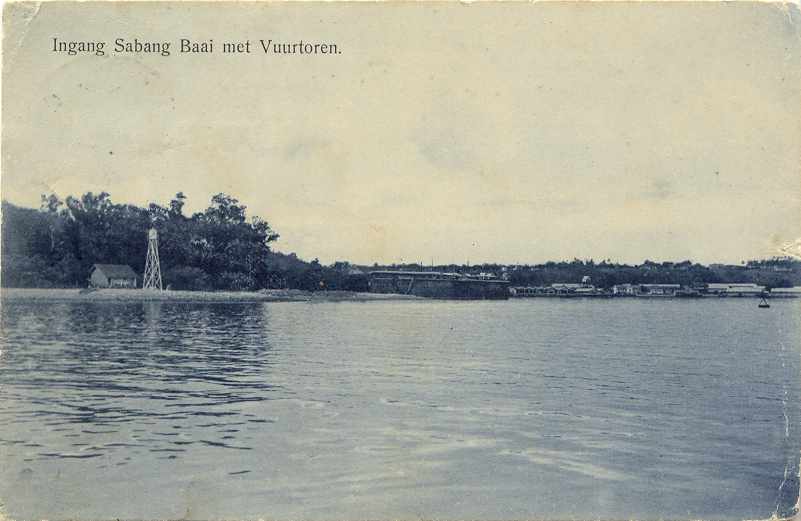
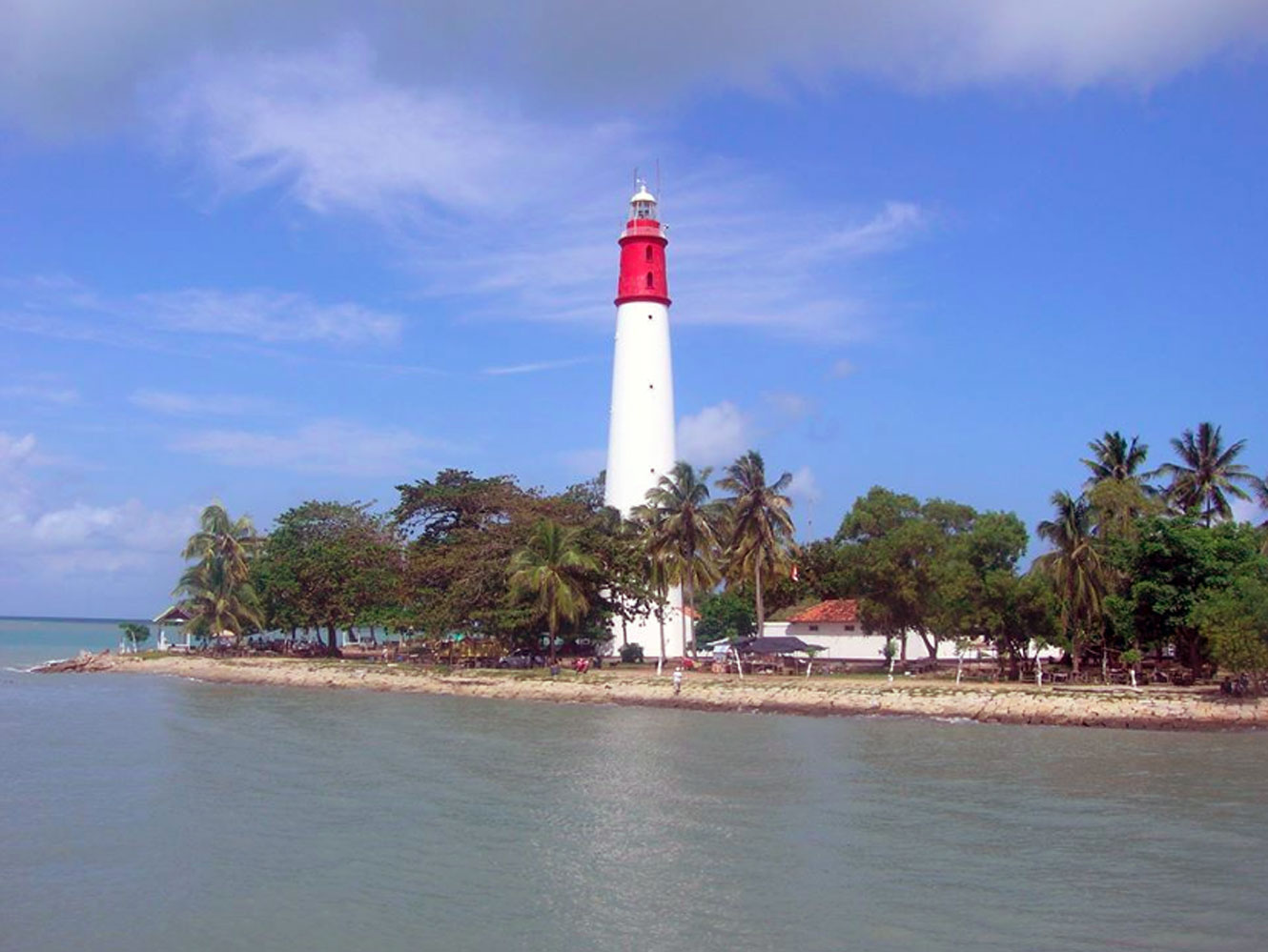
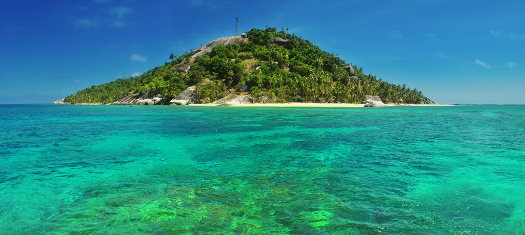
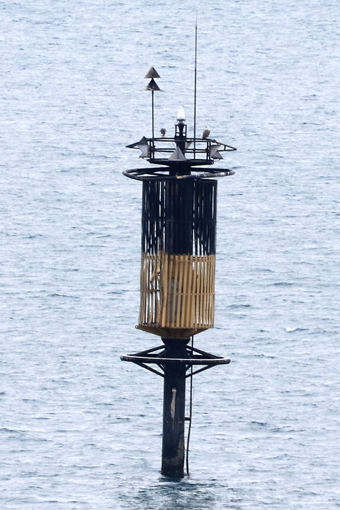
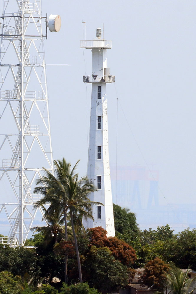
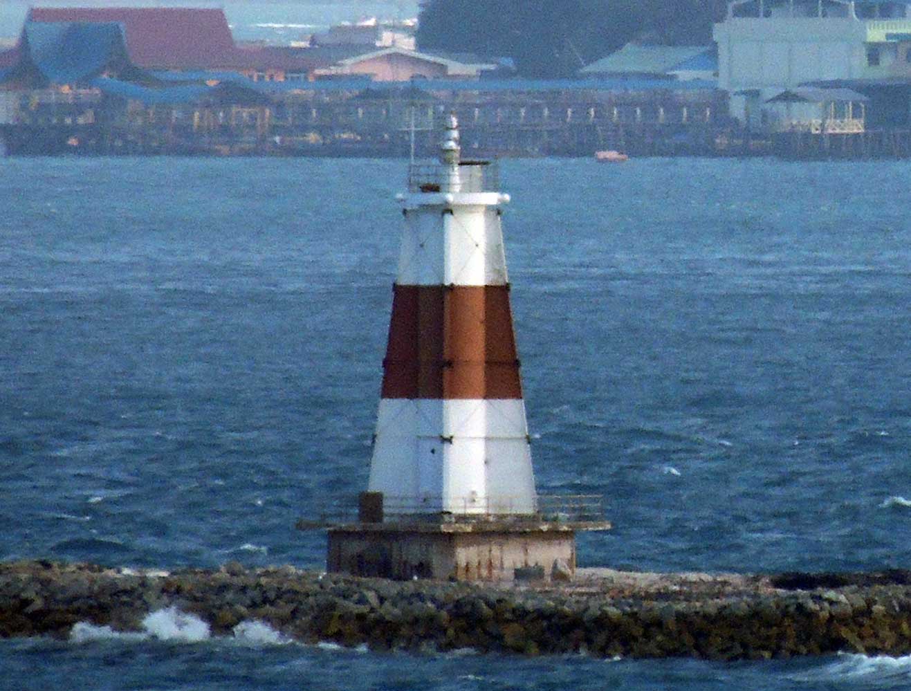
Subscribe to:
Post Comments (Atom)
No comments:
Post a Comment