
Lighthouses of Indonesia: North Maluku (Northern Moluccas)
Indonesia has been independent since 1945 after having been the Dutch East Indies for more than 350 years. It is a huge country, stretching along both sides of the Equator for more than 46 degrees of longitude (roughly 5100 km or 3200 miles). Comprised of some 17,000 islands (more than 6000 inhabited islands), it has hundreds of major aids to navigation.
Maluku (the Moluccas) includes the islands traditionally known in the West as the "Spice Islands." Maluku lies east of Sulawesi (Celebes), south of the Philippines, and west of New Guinea. The Portuguese established a settlement in the islands at Ambon in 1526. They were replaced in 1609 by the Dutch, who established a second colonial settlement at Ternate. Today Ambon is the capital of Maluku province and Ternate was until recently the capital of North Maluku province.
North Maluku (Maluku Utara) includes the large island of Halmahera and nearby islands, notably Morotai to the north, Bacan and Obi to the south, and the Sula Islands to the southwest. On the west the Maluku Sea separates Halmahera from Sulawesi (Celebes). To the northeast is the open Philippine Sea and on the southeast the Halmahera Sea separates Halmahera from Papua (New Guinea). On the south the narrow waters of the Seram Sea separate Halmahera from Seram (Ceram) and the other islands of Maluku Province. The population of the province is barely one million, a small population for Indonesia. The largest settlement, Ternate, is on a small island off the west coast of Halmahera. The provincial capital was moved in 2010 from Ternate to Sofifi on the west coast of Halmahera.
Photos of lighthouses in North Maluku are extremely rare on the Internet. Please let me know if you have or can locate additional photos. Special thanks to Michel Forand for his research in support of this page.
The Indonesian word for a lighthouse is mercusuar. The phrase menara suar, which includes the Arabic word menara, is sometimes used instead. Tanjung and ujung are words for capes, pulau is an island, selat is a strait, karang is a reef, gosong is a shoal or sandbar, teluk is a bay or harbor, and pelabuhan is a port. Aids to navigation in Indonesia are operated and maintained by the Directorate General of Sea Navigation.
ARLHS numbers are from the ARLHS World List of Lights. Admiralty numbers are from volumes F and Q of the Admiralty List of Lights & Fog Signals. U.S. NGA List numbers are from Publication 112.
- General Sources
- World of Lighthouses - Indonesia
- Photos by various photographers available from Lightphotos.net.
- Online List of Lights - Indonesia - Vol. F and Vol. Q
- Photos by various photographers posted by Alexander Trabas.
-
- Tidore Kepulauan (Tidore Islands) Regency Lighthouses
- Tidore is an island off the west coast of Halmahera, south of the more populous island of Ternate. Historically a rival to Ternate, Tidore today has a population of about 50,000. The Tidore Kepulauan (Tidore Islands) Regency also includes the neighboring central west coast of Halmahera.
- * Gita Bandar
- 2017. Active; focal plane 23 m (75 ft); white flash every 3 s. 20 m (66 ft) square white skeletal tower. No photo available but Google has a satellite view. Located on the waterfront at Gita, a small port on the southwestern coast of Halmahera. Site open, tower closed. Admiralty F2107.2.
- * Trikora Tidore (Trikora Bandar, Tidore)
- 2017. Active; focal plane 24 m (79 ft); white flash every 3 s. 20 m (66 ft) square white skeletal tower. Micky Isima has a photo, Zulfikar Lesmana also has a photo, and Google has a satellite view. Located at the ferry terminal on the east side of Pulau Tidore. Site open, tower closed. Admiralty F2106.8.
Ternate City Lighthouses
- Ternate is an island off the west coast of Halmahera. The Sultans of Ternate ruled most of the spice islands in the centuries before Europeans arrived, and from the early 17th century Ternate was the principal Dutch base in the area. With a population of around 200,000, the city of Ternate is the largest city of North Maluku. It was the provincial capital until the capital was moved to the mainland town of Sofifi in 2010.
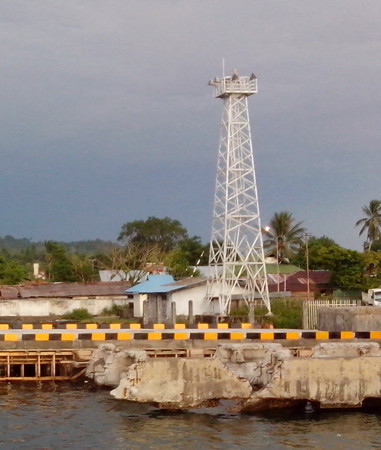
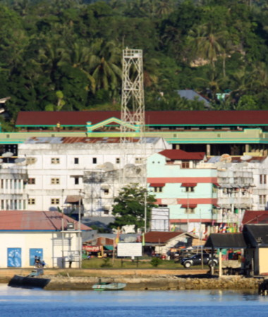
- * Ternate Pier
- Date unknown. Active; focal plane 23 m (75 ft); white flash every 3 s. 20 m (66 ft) skeletal tower, painted white. A photo is at right and Google has a fuzzy satellite view. Located beside the main passenger terminal at Ternate. Site open, tower closed. Admiralty F2100; NGA 25208.
- Tanjung Kahu Merah
- Date unknown. Active; focal plane 32 m (105 ft); two white flashes every 15 s. Approx. 27 m (89 ft) skeletal tower, painted white. No photo available but Google has an indistinct satellite view. Located on the south waterfront of Ternate. Site status unknown (the lighthouse is in a commercial port area). Admiralty F2105; NGA 25212.
- Terminal BBM Ternate
- Date unknown. Active; focal plane about 15 m (49 ft); four quick white flashes every 8 s. Approx. 12 m (39 ft) square white skeletal tower. A view from the sea is available and Google has an indistinct satellite view. Located at the base of the pier at an oil terminal on the southwest side of Ternate. Site and tower closed. Admiralty F2105.5.
- Pulau Hiri
- 2003. Active; focal plane 115 m (377 ft); white flash every 4 s. 30 m (98 ft) skeletal tower, painted white. No photo available but a Google satellite view shows this station. Pulau Hiri is a small island off the northern tip of Pulau Ternate. Located on the west side of the island. Site status unknown. Admiralty F2106; NGA 25217.

Ternate Pier Light (far right), Ternate, September 2014
photo copyright yosgama; permission requested
Pulau Mayau (Mayu) Lighthouses- Pulau Mayau is a high island in the Maluku Sea about halfway between Halmahera and the northeastern tip of Sulawesi. The island is attached administratively to the city of Ternate.
- Tanjung Mayu
- 2003. Active; focal plane 33 m (108 ft); white flash every 5 s. 20 m (66 ft) skeletal tower, painted white. No photo available but Bing has a satellite view. Located on the eastern tip of Pulau Mayu. Accessible only by boat. Site status unknown. Admiralty F2107.56; NGA 25222.8.
- Pulau Mayu (Tanjung Lelew, Pasirputih)
- 2006. Active; focal plane 40 m (131 ft); white flash every 3 s. 40 m (131 ft) skeletal tower, painted white. No photo available but Bing has a satellite view. Located on the western tip of Pulau Mayu. Accessible only by boat. Site status unknown. ARLHS IDO-221; Admiralty F2107.5; NGA 25222.7.
Halmahera Barat (West Halmahera) Regency Lighthouse- Tanjung Babo (Bobo)
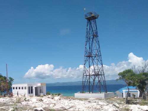
- 2003. Active; focal plane 210 m (689 ft); two white flashes every 6 s. 40 m (131 ft) square pyramidal skeletal tower with lantern and gallery, painted white. Muhammad Faturachman Husin's photo is at right, Ibnu Khoirul Fajar has a 2019 drone view, and Google has a good satellite view. The Admiralty calls the light Tanjung Bobo, but the official sign at right has it as Tanjung Babo. Located on a promontory near the base of Halmahera's northern peninsula, about 25 km (15 mi) north of Ternate. Site status unknown. Admiralty F2107.8; NGA 25222.45.
Halmahera Utara (North Halmahera) Regency Lighthouses- Pulau Sidanga
- 2003. Active; focal plane 93 m (305 ft); white flash every 3 s. 30 m (98 ft) square skeletal tower with gallery, painted white. No photo available but the tower is seen in Google's satellite view. Located on the west side of a small island off the northwestern coast of Halmahera, about 160 km (100 mi) north of Ternate. This island is known as a scuba diving site. Accessible only by boat. Site status unknown. Admiralty F2110.3; NGA 25222.4.
- * Pelabuhan Dama (Pulau Doi)
- Date unknown. Active; focal plane about 22 m (72 ft); white light, pattern unknown. Approx. 20 m (66 ft) square white skeletal tower. Dhany Vapes has a photo, Prasetyo Budi Widagdo has an evening photo, and Google has a satellite view. Pulau Doi is an island off the northwestern tip of Halmahera. Located on the waterfront of Dama, the ferry port for Pulau Doi. Site open, tower closed. Admiralty F2110.1.
- Tobelo (2?)
- Date unknown. Active; focal plane about 12 m (39 ft); white light, characteristic unknown. Approx. 9 m (30 ft) tapered square skeletal tower. A photo (halfway down the page) is available, Wilson Kakunsi has a drone view, and Google has an indistinct satellite view. This light doesn't match the current description of the Tobelo light in NGA (focal plane 9 m (30 ft), 6 m (20 ft) tower, continuous red light). Located on the containership quay at Tobelo, the capital of North Halmahera Regency. Site status unknown. Admiralty F2110; NGA 25222.
- Kupakupa Oil Depot
- Date unknown. Active; focal plane 13 m (43 ft); white flash every 3 s. Approx. 11 m (36 ft) square white skeletal tower. Agunawan Opa has an aerial view and Bing has a satellite view. Located at an oil terminal about 10 km (6 mi) south of Tobelo. Site status unknown. Admiralty F2110.5; NGA 25220.
Pulau Morotai Regency Lighthouses- Morotai is a rugged, mostly forested island north of Halmahera. The island is elliptical in shape, 80 km (50 mi) long and 42 km (26 mi) wide; the population is a little over 50,000. The northernmost major island of Maluku, Morotai is best known as the base for the U.S. invasion of the Philippines in early 1945.
- * Pelabuhan Daruba
- 2018(?). Active; focal plane 23 m (75 ft); white flash every 3 s. 20 m (66 ft) square white skeletal tower. An aerial view is available and Google has a satellite view. Located on the waterfront of Daruba, a port at the southern tip of Morotai. Site open, tower closed. Admiralty F2111.03.
- Pelabuhan Wayabula
- 2018(?). Active; focal plane 25 m (82 ft); white flash every 3 s. 20 m (66 ft) square white skeletal tower. Several station buildings. No photo available but Google has a satellite view. Located at a coast guard station on the west coast of Morotai. Site open, tower closed. Admiralty F2111.45.
- * Morotai Bandar
- 2017. Active; focal plane 23 m (75 ft); white flash every 3 s. 20 m (66 ft) square white skeletal tower. No photo available but Google has a satellite view. Located at the base of the pier at Morotai harbor on the north coast of the island. Site open, tower closed. Admiralty F2111.4.
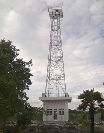
- Tanjung Sopi (Pulau Morotai)
- 2003. Active; focal plane 93 m (305 ft); white flash every 6 s. 40 m (131 ft) square skeletal tower with gallery, painted white. The top of the tower also carries a slatted daymark. Laszlo Wagner's photo is at right, a closeup photo is available, and Google has a satellite view of the station. Package tours of the island sometimes include a visit to the lighthouse. Located at the northern tip of the island. Accessible only by boat. Site open, and nothing prevents visitors from climbing the tower. Admiralty F2111.3; NGA 25222.55.
- * Berebere Bandar
- 2017. Active; focal plane 24 m (79 ft); white flash every 3 s. 20 m (66 ft) square white skeletal tower. No photo available but Google has an indistinct satellite view. Located at the ferry terminal of Berebere on the northeast coast of Pulau Morotai. Site open, tower closed. Admiralty F2111.1.

Tanjung Sopi Light, Pulau Morotai
photo copyright Laszlo Wagner, East-Indonesia.info; used by permission
Halmahera Timur (East Halmahera) Regency Lighthouse- * Pelabuhan Buli
- 2018(?). Active; focal plane 24 m (79 ft); white flash every 3 s. 20 m (66 ft) square white skeletal tower. Arief E. Saputro has a 2019 photo but the new tower does not appear in Google's current satellite view. Located on the waterfront of Buli, a port on the east side of the base of the northeastern peninsula of Halmahera. Site open, tower closed. Admiralty F2109.3.
- Pulau Leleve
- 2006. Active; focal plane 26 m (85 ft); white flash every 5 s. 20 m (66 ft) white concrete tower. No photo available but Google has a good satellite view. Located on a small island in Buli Bay, off the east coast of Halmahera about 20 km (13 mi) north of Bicoli. Accessible only by boat. Site status unknown. Admiralty F2109.6.
Halmahera Tengah (Central Halmahera) Regency Lighthouses- Pulau Yiew (Jiuw)
- 2006. Active; focal plane 45 m (148 ft); two white flashes every 10 s. 40 m (131 ft) square white skeletal tower. No photo available but Bing has a satellite view. Located on a small island about 50 km (30 mi) northeast of the eastern tip of Halmahera's eastern peninsula, marking the northern entrance to the Halmahera Sea. Accessible only by boat. Site status unknown. Admiralty F2109.8; NGA 25222.65.
- Tanjung Sofa (Jailolo Strait)
- Date unknown. Active; focal plane 71 m (233 ft); white flash every 10 s. 40 m (131 ft) square white skeletal tower. Several 1-story station buildings. No photo available but Bing has a satellite view of the station. This lighthouse is less than 5 km (3 mi) north of the Equator. Located at the northwestern tip of Pulau Gebe, marking a narrow passage around the eastern tip of Halmahera. Accessible only by boat. Site status unknown. Admiralty F2111.8; NGA 25222.6.
- * Pelabuhan Weda
- 2016. Active; focal plane 23 m (75 ft); white flash every 3 s. 20 m (66 ft) square skeletal tower. Indra Satya Nagari has a 2017 photo, Rustam Gebsy also has a photo, and Google has a satellite view. Weda is the capital of the Central Halmahera Regency. Located at the foot of the ferry pier in Weda. Site open, tower closed. Admiralty F2109.85.
Halmatera Selatan (South Halmahera) Regency: Bacan Islands Lighthouses- The Bacan Islands lie off the west coast of Halmahera's southern peninsula. Pulau Bacan itself is the largest of the islands.
- Tanjung Gegoru
- Date unknown. Active; focal plane about 15 m (49 ft); light characteristic unknown. Approx. 14 m (46 ft) round barbell-shaped tower. No photo available but Google has a satellite view. Located at the western tip of Pulau Mandioli, marking the southwestern point of the Bacan Islands. Probably accessible only by boat. Site status unknown. Admiralty Q1585.5.
- Pulau Sarangburung (Lata Lata)
- Date unknown. Active; focal plane 14 m (46 ft); white flash every 2 s. 10 m (33 ft) square skeletal tower painted white. No photo available but Bing has a distant satellite view. Located on a small island at the northwestern point of the Bacan Islands. Accessible only by boat. Site status unknown. Admiralty Q1582; NGA 25771.
- * Pelabuhan Busua
- 2017. Active; focal plane 23 m (75 ft); white flash every 3 s. 20 m (66 ft) square skeletal tower. Sultan Bosthon's January 2018 photo is at right but the tower is not yet seen in Bing's satellite view. Located at the foot of the ferry pier in Basua, a small port at the northeastern end of Pulau Muari. Site open, tower closed. Admiralty Q1583.
- Pokal
- Date unknown. Active; focal plane 110 m (361 ft); two white flashes every 15 s. Approx. 40 m (131 ft) square skeletal tower, painted white. No photo available but Bing has a satellite view. Located on a small island in the center of the narrow Patientie Strait separating southwestern Halmahera from the neighboring Pulau Bacan. Accessible only by boat. Site status unknown. Admiralty Q1588; NGA 25770.
- * Babang
- Date unknown. Active; focal plane 14 m (46 ft); white flash every 6 s. 12 m (39 ft) round concrete tower, flared at the top and buttressed at the base. Merky Bolung's distant view is at right, Google has a street view and Bing has a satellite view. Located on the waterfront of Babang, a town on the east coast of Pulau Bacan, the largest of the Bacan Islands. Site open, tower closed. Admiralty Q1587.5; NGA 25769.
Halmatera Selatan (South Halmahera) Regency: Pulau Makian Lighthouse- Pulau Makian
- 2003. Active; focal plane 25 m (82 ft); white flash every 5 s. 20 m (66 ft) tapered square skeletal tower, painted white. No photo available but Bing has a satellite view. Pulau Makian is a volcanic island off the west coast of Halmahera about 60 km (38 mi) south of Ternate. Located on the western tip of the island. Site status unknown. Admiralty F2107.3; NGA 25210.

Babang Light, Bacan Islands, September 2009
ex-Panoramio Creative Commons photo by merky.bolung
Halmatera Selatan (South Halmahera) Regency: Obi Islands Lighthouses- The Obi Islands lie to the south of Halmahera and north of Seram. Obira (also called Obi and Obi Mayor) is by far the largest of the islands.
- Pulau Laiola (Pulau Lawin)
- Date unknown. Active; focal plane 34 m (112 ft); two white flashes every 6 s. 30 m (98 ft) square skeletal tower, painted white. Several 1-story station buildings. No photo available, but Bing has a satellite view of the light station. Located on Pulau Laiola, a small island off the southeast side of Pulau Lawin, in the Halmahera Sea about 55 km (35 mi) east of the island of Obira. Accessible only by boat. Site status unknown. Admiralty Q1603; NGA 25764.
- * Jikotamo Bandar (Pelabuhan Jikotamo)
- Date unknown. Active; focal plane 23 m (75 ft); white flash every 3 s. 20 m (60 ft) skeletal tower, painted white. Januar Retristian's photo is at right, Viktor Rendra has a 2018 photo, Ahmad Siroji has a 2019 photo, Pardi Laapo has a photo, and Google has a satellite view. Located at the Jikotamo ferry port on the north coast of Pulau Obira. Site open, tower closed. Admiralty Q1589.
- Tanjung Wok (Woka)
- Date unknown. Active; focal plane 17 m (56 ft); white light, 5 s on, 7 s off. 17 m (56 ft) "white beacon." No photo available. The Admiralty's position data for this light appears to be incorrect. The tower is not seen in Bing's satellite view of the area. Located (apparently) at the tip of a promontory on the north coast of Pulau Obira. Site status unknown. Admiralty Q1591; NGA 25766.
- Pelabuhan Wayaloar ("Wai Lower")
- Date unknown. Active; focal plane 23 m (75 ft); white flash every 3 s. 20 m (66 ft) square white skeletal tower. No photo available but Bing has a satellite view. The Admiralty interpreted the name of this village as "Wai Lower." Located at the ferry terminal at Wayaloar, a small port on the south coast of Pulau Obira. Site open, tower closed. Admiralty Q1590.8.
- Tanjung Akelamo
- Date unknown. Active; focal plane 46 m (151 ft); white flash every 10 s. 40 m (131 ft) octagonal white concrete tower with gallery. Several 1-story station buildings. No photo available but Bing has a good satellite view of the station. Located on the southwestern tip of Pulau Obira, marking the east side of the southern entrance to the Maluku Sea. Site status unknown. Admiralty Q1590.5.
Sula Islands Regency Lighthouses- The Sula Islands are to the west of the Obi islands. Of the three largest islands, Taliabu and Mangole are in a west-east line, while Sanana is at right angles south of Mangole. Taliabu became a separate regency in 2013.
- Tanjung Dehekalano (Pulau Lifumatola)
- Date unknown. Active; focal plane 65 m (213 ft); three white flashes every 20 s. 40 m (131 ft) skeletal tower, painted white. Several 1-story station buildings. No photo available but Google has a satellite view of the station. Located at the eastern tip of Pulau Lifumatola, at the extreme eastern end of the Sula Islands, marking the west side of the southern entrance to the Maluku Sea. Site status unknown. Admiralty Q1592; NGA 25742.
- * Falabisahaya (Pulau Mangole)
- Active; focal plane about 23 m (75 ft); flashing white light. Approx. 20 m (66 ft) square skeletal tower painted white. Hidayat Syamsi's 2018 photo is at right and Giga Nusantara has a November 2016 photo but the tower is too new to appear in Google's satellite view. Located at the foot of the pier in Falabisahaya harbor on the central north coast of Pulau Mangole. Site open, tower closed. Not listed by the Admiralty.
- Sanana Entrance North
- Date unknown. Active; focal plane 18 m (59 ft); red flash every 5 s. 15 m (49 ft) square skeletal tower painted red and mounted on a square platform supported by piles. No photo available but Google has a satellite view. Located on the north side of the entrance to Sanana harbor. Accessible only by boat. Site open, tower closed. Admiralty Q1601; NGA 25756.
- Sanana Entrance South
- Date unknown. Active; focal plane 14 m (46 ft); green flash every 3 s. 14 m (46 ft) round green barbell-shaped fiberglass tower mounted on a square platform supported by piles. No photo available but Google has a satellite view. Located on the south side of the entrance to Sanana harbor. Accessible only by boat. Site open, tower closed. Admiralty Q1601.3; NGA 25756.5.
- * Pelabuhan Sanana (1)
- Date unknown. Inactive. Approx. 12 m (39 ft) round white barbell-shaped tower. A view from the sea is available and this tower is at the right in a 2019 photo. Located near the newer and taller tower (next entry). Site open, tower closed.
- * Pelabuhan Sanana (2)
- Date unknown. Active; focal plane about 23 m (75 ft); white flash every 5 s. Approx. 20 m (66 ft) square skeletal tower painted white. Giga Nusantara's October 2016 photo is at the top of this page, a 2019 photo is available and Google has a satellite view. Located at the foot of the pier in Sanana harbor, near the northeastern corner of the island. Site open, tower closed. Admiralty Q1601.2.

Pelabuhan Falabisahaya Light, Pulau Mangole, October 2018
Google Maps photo by Hidayat Syamsi
- Tanjung Waka
- Date unknown. Active; focal plane 50 m (164 ft); three white flashes every 15 s. Approx. 45 m (148 ft) square tapered skeletal tower, painted white. Four 1-story station buildings. No photo available but Bing has a satellite view of the station. Located on the southern tip of the narrow island of Sanana, marking the passage between that island and Buru. Site status unknown. Admiralty Q1601.15; NGA 25754.5.
- * Malbufa Inner
- Date unknown. Active; focal plane 18 m (56 ft); red flash every 5 s. 15 m (49 ft) square skeletal tower painted green and mounted on a square platform supported by piles. No photo available but Google has a satellite view. Located on a shoal about 800 m (1/2 mi) off Malbufa, a village on the northwest coast of Pulau Sanana. Accessible only by boat. Site open, tower closed. Admiralty Q1601.16.
- * Malbufa Outer
- Date unknown. Active; focal plane 18 m (56 ft); green flash every 5 s. 15 m (49 ft) square skeletal tower painted green and mounted on a square platform supported by piles. No photo available but Google has a satellite view. Located on a shoal about 1.6 km (1 mi) off Malbufa. Accessible only by boat. Site open, tower closed. Admiralty Q1601.17.
Taliabu Regency Lighthouses- Pulau Sehu (Seku)
- Date unknown. Active; focal plane 60 m (197 ft); two white flashes every 15 s. Tower described only as a white beacon. No photo available and the light has not been found in Google's satellite view of the area. This light and the Pulau Buangbuang Light (see the Northeastern Sulawesi page) frame the entrance to the Maluku Sea from the Banda Sea. Located on a promontory on the west side of Pulau Sehu, an island off the southwestern tip of Pulau Taliabu. Accessible only by boat. Site status unknown. Admiralty Q1569.5; NGA 25384.
- * Bobong (2?)
- Active; focal plane about 23 m (75 ft); flashing white light. Approx. 20 m (66 ft) square skeletal tower painted white. Eriko Utama's beach view is at right and Usman Ramli has a distant street view but the tower is not seen in Bing's satellite view of the waterfront. Bobong, at the western end of Pulau Taliabu, is the capital of the Taliabu Regency. Located on the waterfront harbor of Taliabu. Site open, tower closed. Admiralty Q1570.
Information available on lost lighthouses:
Notable faux lighthouses:
Maluku (the Moluccas) includes the islands traditionally known in the West as the "Spice Islands." Maluku lies east of Sulawesi (Celebes), south of the Philippines, and west of New Guinea. The Portuguese established a settlement in the islands at Ambon in 1526. They were replaced in 1609 by the Dutch, who established a second colonial settlement at Ternate. Today Ambon is the capital of Maluku province and Ternate was until recently the capital of North Maluku province.
North Maluku (Maluku Utara) includes the large island of Halmahera and nearby islands, notably Morotai to the north, Bacan and Obi to the south, and the Sula Islands to the southwest. On the west the Maluku Sea separates Halmahera from Sulawesi (Celebes). To the northeast is the open Philippine Sea and on the southeast the Halmahera Sea separates Halmahera from Papua (New Guinea). On the south the narrow waters of the Seram Sea separate Halmahera from Seram (Ceram) and the other islands of Maluku Province. The population of the province is barely one million, a small population for Indonesia. The largest settlement, Ternate, is on a small island off the west coast of Halmahera. The provincial capital was moved in 2010 from Ternate to Sofifi on the west coast of Halmahera.
Photos of lighthouses in North Maluku are extremely rare on the Internet. Please let me know if you have or can locate additional photos. Special thanks to Michel Forand for his research in support of this page.
The Indonesian word for a lighthouse is mercusuar. The phrase menara suar, which includes the Arabic word menara, is sometimes used instead. Tanjung and ujung are words for capes, pulau is an island, selat is a strait, karang is a reef, gosong is a shoal or sandbar, teluk is a bay or harbor, and pelabuhan is a port. Aids to navigation in Indonesia are operated and maintained by the Directorate General of Sea Navigation.
ARLHS numbers are from the ARLHS World List of Lights. Admiralty numbers are from volumes F and Q of the Admiralty List of Lights & Fog Signals. U.S. NGA List numbers are from Publication 112.
- General Sources
- World of Lighthouses - Indonesia
- Photos by various photographers available from Lightphotos.net.
- Online List of Lights - Indonesia - Vol. F and Vol. Q
- Photos by various photographers posted by Alexander Trabas.

Ternate City Lighthouses
| Ternate Pier Light (far right), Ternate, September 2014 photo copyright yosgama; permission requested |
Pulau Mayau (Mayu) Lighthouses
|

Pulau Morotai Regency Lighthouses
| Tanjung Sopi Light, Pulau Morotai photo copyright Laszlo Wagner, East-Indonesia.info; used by permission |
Halmahera Timur (East Halmahera) Regency Lighthouse
Halmahera Tengah (Central Halmahera) Regency Lighthouses
|

| Babang Light, Bacan Islands, September 2009 ex-Panoramio Creative Commons photo by merky.bolung |
Halmatera Selatan (South Halmahera) Regency: Obi Islands Lighthouses
|

Sula Islands Regency Lighthouses
| Pelabuhan Falabisahaya Light, Pulau Mangole, October 2018 Google Maps photo by Hidayat Syamsi |
|

Lighthouses of Indonesia: Central Maluku (Moluccas)
| Indonesia has been independent since 1945, after having been the Dutch East Indies for more than 350 years. It is a huge country, stretching along both sides of the Equator for more than 46 degrees of longitude (roughly 5100 km or 3200 miles). Comprised of some 17,000 islands (more than 6000 inhabited islands), it has hundreds of major aids to navigation. This page includes the lighthouses of the central region of Maluku (the Moluccas), the islands traditionally known in the West as the "Spice Islands." This region is the northern part of Maluku Province, which also includes the islands covered on the Southern Maluku page. Maluku lies east of Sulawesi (Celebes), south of the Philippines, and west of New Guinea. The Portuguese established a settlement in the islands at Ambon in 1526. They were replaced in 1609 by the Dutch, who established a second colonial settlement at Ternate. Today Ambon is the capital of Maluku province, and Ternate was until recently the capital of North Maluku province. Photos of lighthouses in Maluku are extremely rare on the Internet. Please let me know if you have or can locate additional photos. Special thanks to Michel Forand for his research in support of this page. The Indonesian word for a lighthouse is mercusuar. The phrase menara suar, which includes the Arabic word menara, is sometimes used instead. Aids to navigation in Indonesia are operated and maintained by the Directorate General of Sea Navigation. ARLHS numbers are from the ARLHS World List of Lights. Admiralty numbers are from volume Q of the Admiralty List of Lights & Fog Signals. U.S. NGA List numbers are from Publication 112.
|  Amahai Light, Amahai, Central Maluku, February 2013 ex-Panoramio photo copyright Richard Monny; used by permission |
Banda Sea Islands Lighthouses
- Southeast Maluku Regency (Kei Islands) Lighthouses
- Note: The Kei Islands (formerly called the Kai Islands and known to the inhabitants as the Evav Islands) are a group of relatively small islands lying northeast of the Tanimbar group, west of the Aru group, and southeast of the large island of Seram. Tual, the chief town of the archipelago, suffered a severe earthquake in September 2010.
- Tanjung Patingru
- 2015 (?). Active; focal plane 85 m (279 ft); white light occulting once every 11 s. 40 m (131 ft) square skeletal tower painted white. Several 1-story station buildings. No photo available but Bing has a satellite view. This lighthouse is part of a new coast guard station. Located on the northwestern tip of Pulau Kei Besar, the easternmost island of the Kei group. Site status unknown. Admiralty Q1631.5.
- * Elat (2)
- Date unknown. Active; focal plane about 15 m (49 ft); white flash every 3 s. Approx. 13 m (43 ft) round barbell-shaped metal tower. It appears that the lighthouse was painted blue, but most of that paint has worn off. Google has a street view and Bing has a satellite view. Located at the base of a pier in Elat, the principal port of Pulau Kei Besar, on the southwest coast of the island. Site open, tower closed. Admiralty Q1631; NGA 25848.
- Tanimbar Kei (Keitanimbar, Kaitanimbar, Atnebar)
- Date unknown. Active; focal plane 60 m (197 ft); three white flashes every 10 s. Approx. 40 m (131 ft) square white skeletal tower. Two 1-story coast guard station buildings. No photo available, but Google has a satellite view. Located near the only settlement on the island of Atnebar or Tanimbar Kei at the southern end of the Kei group. Accessible only by boat. Site status unknown. Admiralty Q1628.8; NGA 25830.
- Uf Danar (Uf Mar)
- Date unknown. Active; focal plane 23 m (75 ft); white flash every 3 s. 20 m (66 ft) square skeletal tower painted white. No photo available but Bing has a satellite view. Located at the base of a pier at Uf Danar, a small port on the south coast of Pulau Kei Kecil Timur. Site open, tower closed. Admiralty Q1628.93.
- Tual Approach
- Date unknown. Active; focal plane 18 m (59 ft); red flash every 3 s. 18 m (59 ft) red beacon, presumably mounted on a platform supported by piles. No photo available but Bing has a distant satellite view. Located in a narrow channel between the islands of Duroa and Kei Kecil, marking the beginning of the approach to Tual. Accessible only by boat. Site open, tower closed. Admiralty Q1629; NGA 25832.
- * Tual (2)
- Date unknown. Active; focal plane about 23 m (75 ft); white flash every 3 s. Approx. 20 m (66 ft) square skeletal tower painted white. Richard Monny's photo is at right and Google has a street view and a satellite view. NGA lists a smaller tower. Located on the main quay at Tual, the capital of the regency, on Pulau Dullah. Site open, tower closed. Admiralty Q1630; NGA 25840.
- * Dumar (Pelabuhan Perikanan Nusantara Tual)
- Date unknown. Active; focal plane about 20 m (66 ft); white light, pattern unknown. Approx. 17 m (56 ft) square skeletal tower painted white. Ade Prakasa Putra has a photo and Google has a satellite view. Located at a port about 2 km (1.25 mi) north of the main Tual port. Site open, tower closed. Admiralty Q1629.9.
- Ngadi
- Date unknown. Active; focal plane 18 m (59 ft); white light, 2 s on, 3 s off. 15 m (49 ft) square skeletal tower painted white. No photo available but Bing has a satellite view. Located at a commercial port about 5 km (3 mi) north of the main Tual port. Site open, tower closed. Admiralty Q1629.36; NGA 25834.
- Pulau Kur (Koer)
- Date unknown. Active; focal plane 120 m (394 ft); three white flashes every 20 s. 40 m (131 ft) square skeletal tower with gallery, painted white. Several 1-story station buildings. No photo available, but Google has a satellite view of the station. Pulau Kur is about 80 km (50 mi) northwest of Pulau Kei Kecil, the northernmost major island of the Kei group. Located at the northeastern tip of the island. Accessible only by boat. Site status unknown. Admiralty Q1628.5; NGA 25828.
- Pelabuhan Pulau Kur (Koer)
- Date unknown. Active; focal plane about 18 m (59 ft); white light, pattern unknown. Approx. 16 m (52 ft) square skeletal tower rising from a 1-story square equipment room, painted white. Bung Randi has a distant view and Google has a satellite view. Located at base of the pier at Pulau Kur. Accessible only by boat. Site open, tower closed. Admiralty Q1628.2.
- Pulau Bui
- Date unknown. Active; focal plane 15 m (49 ft); white flash every 5 s. 15 m (49 ft) iron skeletal tower, painted white. No photo available, but Bing has a satellite view. Located at the northwestern tip of the island of Bui about 30 km (19 mi) north of the Pulau Kur light and about 175 km (110 mi) southeast of Ceram. Accessible only by boat. Site status unknown. ARLHS IDO-117; Admiralty Q1628; NGA 25824.
Central Maluku Regency: Remote Banda Sea Lighthouses- Note: The Banda Islands are a small group in the Banda Sea about 200 km (125 mi) southeast of Ambon. Until the mid 19th century the islands were world's only source of the spices nutmeg and mace. The islands are administered as part of the Central Maluku Regency.
- * Banda Naira (Bandanaira, Pulau Naira) (2)
- Date unknown (2017?). Active; focal plane 16 m (52 ft); white flash every 3 s. 14 m (46 ft) square white skeletal tower on a concrete base. Semmie Hukom's photo is at right and Google has a distant satellite view of the location. This lighthouse replaced a 12 m (39 ft) tower with a flared top. Located on the quay at Banda Naira, the principal town of the islands. Site open, tower closed. Admiralty Q1626; NGA 25812.
- Tanjung Bati (Lautaka) (2?)
- Date unknown. Active; focal plane about 40 m (131 ft); red flash every 10 s. Approx. 20 m (66 ft) square skeletal tower. Efilina Kissiya has a photo and Bing has a satellite view. NGA lists a much smaller and lower tower. Located on a promontory on the east side of the entrance to the sheltered bay of Banda Naira. Site status unknown. Admiralty Q1626.5; NGA 25816.
- Pulau Suanggi
- Date unknown. Active; focal plane 122 m (400 ft); three white flashes every 15 s. 15 m (49 ft) square skeletal tower, painted white. A distant view is available, and Bing has a distant satellite view. Note that there is another Pulau Suanggi light near Ambon (see below). Located atop a small island at the northwestern end of the Banda group. Accessible only by boat. Site status unknown. Admiralty Q1625; NGA 25808.
- Pulau Bingkudu
- Date unknown. Active; focal plane 25 m (82 ft); white flash every 5 s. 20 m (66 ft) white concrete tower. No photo available but Bing has a satellite view. Located on a tiny island, the northernmost of the Penyu (Turtle) group, in the Banda Sea about 350 km (220 mi) south of Ambon (these islands are not seen at all in Google's satellite view). Accessible only by boat. Site status unknown. Admiralty Q1598; NGA 25810.
- Pulau Mai
- Date unknown. Active; focal plane 32 m (105 ft); three white flashes every 15 s. 30 m (98 ft) square skeletal tower painted white. Three 1-story coast guard station buildings. No photo available but Bing has a satellite view of the station. Located on a small island, the southernmost of the Penyu (Turtle) group, in the Banda Sea about 350 km (220 mi) south of Ambon. Accessible only by boat. Site status unknown. Admiralty Q1597.5.
- Pulau Manuk
- Date unknown. Active; focal plane and light characteristic unknown. Approx. 35 m (115 ft) square skeletal tower. Chandra Morsono's photo is at right and Bing has an indistinct satellite view. Pulau Manuk is isolated, uninhabited island in the middle of the Banda Sea about 115 km (72 mi) south southeast of Banda Naira. Accessible only by boat. Site status unknown. Not listed by the Admiralty.
|
|  Tual Light, Kei Islands, June 2012 ex-Panoramio photo copyright Richard Monny; used by permission |
|
|

|
|

Seram and Ambon Lighthouses
- Note: Seram (formerly spelled Ceram) is the largest island of Maluku Province, about 360 km (225 mi) long and 50 km (30 mi) wide. Lying east to west, it separates the narrow Seram Sea to the north from the broad Banda Sea to the south. Ambon Island lies off the southwest coast of Seram, separated by a narrow strait. The provincial capital, Ambon City, is on a southwestern peninsula of Ambon Island, facing the deep sound of Ambon Bay. With a population of about 275,000, it is the largest city of eastern Indonesia.
Central Maluku Regency: Seram North Coast Lighthouses- Teluk Hatiling Entrance West
- Date unknown. Active; focal plane 18 m (59 ft); green flash every 10 s. 15 m skeletal (?) tower, painted green and mounted on a square platform supported by piles. No photo available but Google has a satellite view. Teluk Hatiling (Hatiling Bay), a few miles east of the village of Wahai, is the deepwater port for the North Seram District. Located at the edge of the reef on the east side of the entrance to Hatiling, a harbor on the central north coast of Seram. Accessible only by boat. Site open, tower closed. Admiralty Q1605.
- Teluk Hatiling Entrane East
- Date unknown. Active; focal plane 18 m (59 ft); red flash every 10 s. 15 m skeletal (?) tower, painted red and mounted on a square platform supported by piles. No photo available but Google has a satellite view. Located at the edge of the reef on the west side of the entrance to Hatiling, a harbor on the central north coast of Seram. Accessible only by boat. Site open, tower closed. Admiralty Q1605.1.
- * Teluk Hatiling
- Date unknown. Active; focal plane 23 m (75 ft); white flash every 3 s. 20 m (66 ft) skeletal tower, painted white. No photo available but Bing has a satellite view. Located at the passenger terminal. Site open, tower closed. Admiralty Q1605.6.
- * Kobisadar (Kobi Sadar)
- Date unknown. Active; focal plane about 23 m (75 ft); white light, flash every 3 s (?). Approx. 20 m (66 ft) skeletal tower, painted white. Giliat Tapatab's photo is at right and Bing has a satellite view. Located at the passenger terminal at Kobisadar, a small port about 40 km (25 mi) east of Wahai. Site open, tower closed. Admiralty Q1605.68.
East Seram Regency Lighthouses- * Sesar Bula
- Date unknown. Active; focal plane 22 m (72 ft); white flash every 3 s. 20 m (66 ft) square skeletal tower painted white. The tower is at the right edge of Tember Susena's photo, Albani Medis Medis has a distant view from the sea, and Google has a satellite view. Bula, on the northeast coast of Seram, is the capital of East Seram Regency. Located on the quay of a new port northwest of Bula. Site status unknown. Admiralty Q1605.9.
- Tanjung Namatimor
- Date unknown. Active; focal plane about 22 m (72 ft); white light, pattern unknown. Approx. 20 m (66 ft) square white skeletal tower. Achmad Jamal has a view from the pier and Google has a satellite view. Located at a petroleum port on the east side of Bula. Site and tower closed. Admiralty Q1607.2.
- * Pulau Geser (2)
- Date unknown. Active; focal plane 24 m (79 ft); white flash every 3 s. 20 m (66 ft) square skeletal tower painted white. Agunawan Opa has a photo, Jimmy Syahrasyid has a view from the sea, and Google has a satellite view. NGA lists a 6 m (20 ft) tower at this location. Located on the quay of Pulau Geser, a small island off the southeastern tip of Seram. Site open, tower closed. Admiralty Q1608; NGA 25800.
- Pelabuhan Ondor Gorom (Ondur Port)
- Date unknown. Active; focal plane about 12 m (39 ft); white light, pattern unknown. Approx. 10 m (33 ft) square white skeletal tower. Muhammad Hamsa Kelilauw has a photo and Bing has a satellite view. Located at the foot of the pier of Pulau Gorong, an island about 50 km (30 mi) east of the southeastern tip of Seram. Site and tower closed. Admiralty Q1608.45.
- Tanjung Namalen (Pulau Gorong)
- Date unknown. Active; focal plane about 15 m (49 ft); light characteristic unknown. Approx. 15 m (49 ft) skeletal tower mounted on a square platform supported by piles. No photo available but Bing has a satellite view. This light guides vessels around the eastern end of Seram and its associated islands. Located off the northeastern tip of Pulau Gorong. Accessible only by boat. Site open, tower closed. Admiralty Q1610.5; NGA 25798.
- * Bemu
- 2017. Active; focal plane 23 m (75 ft); white flash every 3 s. 20 m (66 ft) skeletal tower, painted white. Iswan Pattyiha has a distant view and Google has a satellite view. Located at the passenger terminal in Bemu, a small port facing Taluti Bay on the south coast of Seram. Site open, tower closed. Admiralty Q1610.9.
Central Maluku Regency: Seram South Coast Lighthouses- * Tehoru
- 2017. Active; focal plane 23 m (75 ft); white flash every 3 s. 20 m (66 ft) skeletal tower, painted white. Ekson Daliwu has a 2018 photo, the light is at the left in Erwin Harianto's photo, but the tower is too new to appear in Bing's satellite view. Located at the passenger terminal in Tehoru, a district town on the west side of Taluti Bay. Site open, tower closed. Admiralty Q1611.06.
- Tanjung Kuako
- Date unknown. Active; focal plane 17 m (56 ft); white flash every 4 s. 15 m (49 ft) square skeletal tower with gallery, painted white. Muh. Fadhlan Saputro has a view from a popular beach nearby and Bing has a satellite view. Located at the end of narrow peninsula at the eastern entrance to Elpaputih Bay. Site status unknown. Admiralty Q1611.8; NGA 25803.
- * Teluk Amahai (2)
- Date unknown. Active; focal plane 25 m (82 ft); white flash every 3 s. Approx. 21 m (69 ft) square skeletal tower with gallery, painted white. Richard Monny's photo is at the top of this page, and Google has a closeup photo and an indistinct satellite view. NGA lists a 9 m (30 ft) tower. Amahai is a seaport sheltered by Tanjung Kuako. Located on the quay at Amahai. Site open, tower closed. Admiralty Q1612; NGA 25803.5.
- * Masohi
- Date unknown. Active; focal plane 14 m (46 ft); white flash every 4 s. 15 m (49 ft) square skeletal tower with gallery, painted white. Mike Tuhuteru has a 2018 view from the bay, Ade Fadii has a very distant street view, and Google has an indistinct satellite view. Located on the new quay at Masohi, about 7 km (4 mi) northeast of Amahai. Site status unknown. Admiralty Q1612.3.
- * Teluk Haria (Pulau Saparua)
- Date unknown. Active; focal plane about 14 m (46 ft); white flash every 5 s. 12 m (39 ft) round barbell-shaped tower. Entire lighthouse is white. Zeth Hattu has a photo and Bing has an indistinct satellite view. Located on the new quay at Haria harbor on the south side of Pulau Saparua, an island off the southwest coast of Seram. Site open, tower closed. Admiralty Q1616; NGA 25804.
Central Maluku Regency and Ambon City: Ambon Lighthouses- * Pelabuhan Tulehu (Tolehu)
- Date unknown. Active; focal plane 20 m (66 ft); white flash every 3 s. 20 m (66 ft) square white skeletal tower. A 2018 view is available and Google has a satellite view. Located on the quay at Tulehu, a ferry port at the east end of Ambon Island. Site open, tower closed. Admiralty Q1623.8.
- Tanjung Nusanive (Nusaniwe, Noesanive)
- Date unknown. Active; focal plane 138 m (453 ft); white flash every 5 s. 30 m (98 ft) skeletal tower with gallery, painted white. Several 1-story coast guard station buildings. No closeup photo available. The lighthouse is at the far right in an aerial photo and Bing has a satellite view of the station. This may be the original lighthouse, a 21 m (69 ft) hexagonal skeletal tower with gallery seen in a 1919 photo posted by the Amsterdam Tropenmuseum. Located at the southern tip of Ambon island, about 13 km (8 mi) southwest of Ambon city. Site status unknown. ARLHS IDO-317; Admiralty Q1620; NGA 25772.
- * Ambon
- Date unknown. Active; focal plane 25 m (82 ft); white flash every 3 s. 20 m (66 ft) tapered square skeletal tower, painted white. Maer Tindoy has a 2018 photo and the tower is to the left of the terminal building in Nawafcell Indramayu's photo at right but the tower is hard to distinguish in Bing's satellite view. Note: this light is in Kota Ambon (Ambon City), which is independent of Central Maluku Regency. Located on the ferry quay in downtown Ambon. Site open, tower closed. Admiralty Q1622; NGA 25782.
- * Pelabuhan Perikanan
- Date unknown. Active; focal plane 12 m (39 ft); white flash every 3 s. 10 m (33 ft) square white skeletal tower mounted on a waterfront building. No photo available but Bing has a satellite view. Located at the Perikanan fishery port on the east side of Ambon City. Site open, tower closed. Admiralty Q1622.5; NGA 25783.
- Wayame
- Date unknown. Active; focal plane about 22 m (72 ft); light characteristic unknown. Approx. 20 m (66 ft) square skeletal tower. No photo available but Bing has a satellite view. Located at a Pertamina oil terminal across the bay from Ambon city. Site status unknown. Admiralty Q1621.01.
- Tanjung Sikula
- Date unknown. Active; focal plane approx. 15 m (49 ft); red flash every 10 s. 13 m (43 ft) square cylindrical skeletal tower, painted white. No photo available but Bing has a satellite view. Located on a point of land on the north side of the bay of Ambon, about 8 km (5 mi) west of the city. Site status unknown. Admiralty Q1621; NGA 25776.
- Pulau Nusatelu (Pulau Ela)
- Date unknown. Active; focal plane 60 m (197 ft); white flash every 4 s. Approx. 12 m (39 ft) white concrete post with gallery. No photo available but Bing has a distant satellite view. This light marks the entrance to the protected Piru Bay separating Ambon and Seram. Located on an island off the northwestern coast of Ambon island. Accessible only by boat. Site status unknown. Admiralty Q1619; NGA 25773.
West Seram Regency Lighthouses- Pulau Kasa (Teluk Piru)
- Date unknown. Active; focal plane 14 m (46 ft); white flash every 5 s. Approx. 12 m (39 ft) square white skeletal tower. No photo available but Google has a satellite view. Located on the southern tip of Pulau Kasa, an island off the east side of the entrance to Latira Bay, a deep inlet of Piru Bay at the west end of Seram. Accessible only by boat. Site status unknown. Admiralty Q1613; NGA 25806.
- * Hatu Piru Bandar
- 2017. Active; focal plane 23 m (75 ft); white flash every 3 s. 20 m (66 ft) skeletal tower, painted white. Stevy Yotlely has a view from the end of the pier and Google has a satellite view. Located at the foot of the pier and a new deepwater port for Piru, a port at the northern end of Latira Bay. Site open, tower closed. Admiralty Q1612.75.
- Pulau Suanggi (Sunggi)
- Date unknown (station established 1904). Active; focal plane 94 m (308 ft); two white flashes every 10 s. 21 m (69 ft) iron skeletal tower, painted white. No photo available but Google has a satellite view. This light guides vessels through a narrow strait between the islands of Buru and Seram (Ceram). Note that there is another Pulau Suanggi Light in the Banda Sea Islands (see above). Located on Pulau Suanggi, a small island off the western tip of Pulau Manipa, about 80 km (50 mi) northwest of Ambon, the capital of Maluku province. Site status unknown. ARLHS IDO-249; Admiralty Q1600; NGA 25752.
- Pulau Niene
- Date unknown. Active; focal plane 60 m (197 ft); two white flashes every 15 s. Approx. 40 m (131 ft) square white skeletal tower. No photo available but Bing has a satellite view. Located on a small island on the north side of Pulau Boano, off the northwestern tip of Seram (Ceram). Accessible only by boat. Site status unknown. Admiralty Q1600.5; NGA 25754.
|
|

|
|  Ambon Light (left) and Ferry Terminal, Ambon, September 2012 ex-Panoramio Creative Commons photo by Nawafcell Indramayu |
Buru Lighthouses
- Note: Buru is a large, roughly elliptical island to the west of Seram, from which it is separated by the Manipa Strait. The mountainous island is about 130 km (80 mi) long and 90 km (55 mi) wide.
- Buru Regency Lighthouses
- * Teluk Bara (Bara Bay)
- 2017. Active; focal plane 23 m (75 ft); white flash every 3 s. 20 m (66 ft) skeletal tower, painted white. No photo available and the tower is too new to appear in Google's satellite view. Located at a brand-new deepwater port at Bara Bay on the northwest coast of Buru. Site open, tower closed. Admiralty Q1597.3.
- Tanjung Karbau (Kerbau) (2)
- Date unknown. Active; focal plane about 30 m (98 ft); white flash every 3 s. Approx. 20 m (66 ft) square white skeletal tower with gallery. No photo available but Bing has a satellite view. NGA lists a smaller tower. Located on a promontory about 3 km (2 mi) east of Namlea, a port at the northeastern corner of Buru and capital of Buru Regency. Site status unknown. Admiralty Q1599; NGA 25750.
- Namlea Pierhead
- 2007 (?). Active; focal plane 33 m (108 ft); two white flashes every 10 s. 30 m (98 ft) square skeletal tower, painted white. Safirotul Huda's photo is at right, Alfaris Raltul has a 2019 photo, and Google has a satellite view. NGA formerly listed a small post light at Namlea; the old light (Admiralty Q1594) was at an older port and may still exist. NGA's application of Q1594 to the new light is incorrect. Located on the waterfront at Namlea, a port at the northeastern corner of Buru. Site status unknown. Admiralty Q1594.5; NGA 25748.
Southern Buru Regency Lighthouses- * Ulima
- 2015(?). Active; focal plane 22 m (72 ft); white flash every 3 s. 20 m (66 ft) square skeletal tower painted white. Johannes Hukygah has a 2016 photo and Google has a satellite view. Located on the quay at Ulima, a small port on the north coast of Pulau Ambelau, an island off the southeastern coast of Buru. Site open, tower closed. Admiralty Q1599.3.
- Tanjung Bartutui
- 2003. Active; focal plane 116 m (381 ft); three white flashes every 10 s. 40 m (131 ft) square pyramidal skeletal tower, mounted atop a 1-story building. Several 1-story coast guard buildings. Lighthouse painted white. No photo available, but Bing has a satellite view. This light marks the southern entrance to the Manipa Strait, the passage between Buru and Seram. Located on the southern tip of Pulau Ambelau. Site status unknown. Admiralty Q1599.5; NGA 25751.
- * Namrole
- 2015(?). Active; focal plane 22 m (72 ft); white flash every 3 s. 20 m (66 ft) square skeletal tower painted white. Ongki Makatita has a 2017 aerial photo and Bing has a satellite view of the port. Located on the quay at Namrole, a small port on the central south coast of Buru. Site open, tower closed. Admiralty Q1595.
- * Leksula (1)
- Date unknown. Inactive. Approx. 12 m (39 ft) round barbell-shaped white tower. The tower is seen in the background of a 2017 photo and is centered in a Bing satellite view of the port. It is possible that this tower will be removed. Located next to the passenger terminal at Leksula, a small port on the southwest coast of Buru. Site open, tower closed.
- * Leksula (2)
- Date unknown. Active; focal plane about 22 m (72 ft); white flash every 3 s (?). Approx. 20 m (66 ft) square skeletal tower painted white. A 2017 photo is available, and Google has a satellite view. Located on the quay at Leksula. Site open, tower closed. Admiralty Q1596; NGA 25744.
- Pulau Fogi
- Date unknown. Active; focal plane 153 m (502 ft); two white flashes every 15 s. 40 m (131 ft) square skeletal tower with gallery, painted white. Google has a street view and Bing has a satellite view of the station. Located on a small island just off the western tip of Buru. Accessible only by boat. Site status unknown. Admiralty Q1597; NGA 25746.
|
|

Lighthouses of Indonesia: Southern Maluku (Moluccas)
| Indonesia has been independent since 1945, after having been the Dutch East Indies for more than 350 years. It is a huge country, stretching along both sides of the Equator for more than 46 degrees of longitude (roughly 5100 km or 3200 miles). Comprised of some 17,000 islands (more than 6000 inhabited islands), it has hundreds of major aids to navigation. This page includes the lighthouses of the southern and southeastern portions of Maluku Province. The province includes the central and southern islands of Maluku (the Moluccas), the islands traditionally known in the West as the "Spice Islands." Maluku lies east of Sulawesi (Celebes), south of the Philippines, and west of New Guinea. The islands covered by this page lie between the larger islands of Timor and New Guinea, separating the Banda Sea to the northwest from the Arafura Sea to the southeast. Photos of lighthouses in Maluku are extremely rare on the Internet. Please let me know if you have or can locate additional photos. Special thanks to Michel Forand for his research in support of this page. The Indonesian word for a lighthouse is mercusuar. The phrase menara suar, which includes the Arabic word menara, is sometimes used instead. Aids to navigation in Indonesia are operated and maintained by the Directorate General of Sea Navigation. ARLHS numbers are from the ARLHS World List of Lights. Admiralty numbers are from volume Q of the Admiralty List of Lights & Fog Signals. U.S. NGA List numbers are from Publication 112.
|  Pulau Lakor Light, Leti Islands, November 2012 ex-Panoramio photo copyright Darell Tristan Utanmeru used by permission |
Maluku Barat Daya (Southwest Maluku) Regency Lighthouses
- Note: These islands lie north and east of Timor at the extreme eastern end of the Lesser Sunda Islands. There are two chains of islands. The northern chain includes the relatively large island of Wetar and a string of smaller islands including Romang and Damar. The southern chain extends from the east end of Timor and includes Kisar, the Leti Islands, Sermata Islands, and Babar Islands.
Wetar Lighthouses- Pulau Liran (Wetar Strait) (2)
- 2010 (?) (station established 1903). Active; focal plane 85 m (279 ft); four white flashes every 40 s. 40 m (131 ft) square skeletal tower with lantern and gallery, painted white. Half a dozen coast guard station buildings. The lighthouse is near the left edge of Bjørn Grøtting's aerial photo and Bing has a satellite view of the station. The original lighthouse was a hexagonal skeletal tower with lantern and gallery; the Amsterdam Tropenmuseum has a 1939 photo. This lighthouse is important in guiding ships toward the island of Timor. Located at the southern tip of Liran, a small island off the southwestern tip of the much larger island of Wetar, about 75 km (45 mi) north northeast of Dili, Timor Leste. Site status unknown. ARLHS IDO-357; Admiralty Q1372; NGA 25716.
- Tanjung Tutuneden (Tutun Eden, Wetar)
- 2007. Active; focal plane 45 m (148 ft); two white flashes every 10 s. 40 m (131 ft) square skeletal tower with lantern and gallery, painted white and rising from a 2-story station building. Alce N. Sudarmanto's photo is at right and Bing has a satellite view. Located on a prominent cape on the south coast of Pulau Wetar. Site status unknown. Admiralty Q1372.3; NGA 25716.3.
- Tanjung Tutunhatoloi (Tutun Hatoloi)
- 2004. Active; focal plane 90 m (295 ft); white flash every 7 s. 30 m (98 ft) square skeletal tower with gallery, painted white. No photo available but Google has a satellite view. Located at the northeastern corner of Wetar. Site status unknown. Admiralty Q1372.5; NGA 25716.6.
Romang Lighthouse- Pulau Nyata
- Date unknown. Active; focal plane 35 m (115 ft); three white flashes every 15 s. Approx. 30 m (98 ft) square skeletal tower with gallery, painted white. No photo available but Google has a satellite view. Located on Pulau Nyata, off the west side of the larger Pulau Romang, about 50 km (30 mi) east northeast of Pulau Wetar. Accessible only by boat. Site status unknown. Admiralty Q1373.5; NGA 25718.5.
Kisar Lighthouses- Tanjung Tutunmahin (Pulau Kisar)
- 2004. Active; focal plane 90 m (295 ft); white flash every 4.5 s. 30 m (98 ft) square skeletal tower with gallery, painted white. No photo available but Google has a satellite view. Located at the southeastern tip of Kisar, an island about 30 km (19 mi) north of the eastern tip of Timor. Accessible only by boat. Site status unknown. Admiralty Q1373.2.
- * Wonreli (Pantai Wonreli) (2)
- Date unknown. Active; focal plane about 15 m (49 ft); white flash every 3 s. Approx. 12 m (39 ft) square skeletal tower. Entire lighthouse is white. The light is in the background of Ivan Jepe's photo of the ferry terminal and Google has a distant satellite view. This light replaced a round post with two galleries seen in what must be an older photo by Jepe. Located at Wonreli on the west coast of Kisar. Site open, tower closed. Admiralty Q1373; NGA 25718.
Leti Islands Lighthouses- Tanjung Tutpateh (Pulau Leti)
- Date unknown. Active; focal plane 42 m (138 ft); three white flashes every 10 s. 40 m (131 ft) square skeletal tower with lantern and gallery, painted white. Two coast guard station buildings. No photo available but Google has a satellite view of the station. This light and the former Pulau Yako Light in Timor Leste framed a narrow passage around the eastern end of Timor, joining the Banda Sea to the Timor Sea. Located at the western tip of Pulau Leti, westernmost of the three Leti Islands, 35 km (22 mi) east northeast of Pulau Yako. Site status unknown. ARLHS IDO-335; Admiralty Q1374; NGA 25719.
- Serwaru (Pulau Leti)
- Date unknown. Active; focal plane 23 m (75 ft); two white flashes every 7 s. 20 m (66 ft) square pyramidal skeletal tower painted white. A distant view by Darell Tristan Utanmeru is seen at right, another distant view from the sea is available, and Bing has an indistinct satellite view. Located at the base of the ferry pier at Serwaru, on the north coast of Pulau Leti. Site open, tower closed. Admiralty Q1374.3.
- Kaiwatu (Pulau Moa)
- Date unknown. Active; focal plane 23 m (75 ft); two white flashes every 10 s. 20 m (66 ft) square pyramidal skeletal tower painted white. Danang Sucahyo has a photo and Bing has a satellite view. Located on the waterfront at Kaiwatu, near the northwestern end of Pulau Moa, the largest of the Leti Islands. Site open, tower closed. Admiralty Q1374.5.
- Warwawang (Pulau Lakor)
- Date unknown. Active; focal plane 23 m (75 ft); white flash every 6 s. 20 m (66 ft) square pyramidal skeletal tower painted white. Sabiqun Nahar has a distant view and Bing has an indistinct satellite view. Located on the waterfront at Kaiwatu, near the northwestern end of Pulau Moa, the largest of the Leti Islands. Site open, tower closed. Admiralty Q1374.8.
- Pulau Lakor
- 2007. Active; focal plane 35 m (115 ft); two white flashes every 10 s. 30 m (98 ft) square skeletal tower with gallery, painted white, mounted on a square 1-story equipment building. Darell Tristan Utanmeru's photo is at the top of this page and Bing has a satellite view. Pulau Lakor is the easternmost of the three major islands of the Leti group. Located at Keti, a village on the south side of the island. Accessible only by boat. Site open, tower closed. Admiralty Q1375.
Sermata Islands Lighthouse- Meatiy Miarang (Meaty Miarang, Meatimiarang, Brisbane Island)
- 1903. Active; focal plane 25 m (82 ft); three white flashes every 29 s. 23 m (75 ft) hexagonal skeletal tower with lantern and gallery, painted white. Numerous cpast guard station buildings. No photo available but Bing has a satellite view of the station. We really need a photo, because the historic lighthouse may survive here. The lighthouse marks an extensive and dangerous reef system midway between Pulau Lakor, in the Leti group, and Pulau Sermata, the largest island of the Sermata group. Located on a small island at the south end of the reef. Accessible only by boat. Site status unknown. ARLHS IDO-166; Admiralty Q1376; NGA 25720.
Babar Islands Lighthouses- Tepa
- Date unknown. Active; focal plane 23 m (75 ft); white flash every 5 s. 20 m (66 ft) square pyramidal skeletal tower painted white. No photo available but Google has a satellite view. This lighthouse is of fairly recent construction; Mikhail d Djaya's February 2011 photo of the port does not show it. Located on the waterfront at Tepa, on the west side of Pulau Babar, the largest of the Babar Islands, halfway between the Leti and Tanimbar islands. Site open, tower closed. Admiralty Q1376.1.
- Kroing Letwurung
- Date unknown. Active; focal plane 23 m (75 ft); white flash every 10 s. 20 m (66 ft) square pyramidal skeletal tower painted white. No photo available and the lighthouse is not seen in Bing's satellite view. Located on the waterfront at Letwurung, on the west side of Pulau Babar. Site open, tower closed. Admiralty Q1376.2.
- Papilewan (Pulau Masela)
- Date unknown. Active; focal plane 23 m (75 ft); two white flashes every 7.5 s. 20 m (66 ft) square pyramidal skeletal tower painted white. Yudha Robi Hamsah's photo is at right, the lower half of the tower is seen in another December 2016 photo (halfway down the page) but the lighthouse is not seen in Google's indistinct satellite view. Pulau Masela is a small island on the south side of the Babar group. Located at what appears to be a new ferry terminal (not shown in Bing's satellite view) at Papilewan on the north side of Pulau Masela. Site open, tower closed. Admiralty Q1376.25.
- Pulau Masela
- 2007. Active; focal plane 43 m (141 ft); two white flashes every 12 s. 40 m (131 ft) square skeletal tower with lantern and gallery rising from a 2-story coast guard station building. No photo available but Bing has a satellite view of the station. Located at the southern end of the island. Site status unknown. Admiralty Q1376.3.
|
|

|
|  Serwaru Light, Leti Islands, April 2013 ex-Panoramio photo copyright Darell Tristan Utanmeru; used by permission |
|
|
Maluku Tenggara Barat (Western Southeast Maluku) Regency: Tanimbar Islands Lighthouses
- Note: The Tanimbar Islands are roughly halfway between Timor and Papua (New Guinea). There are some 65 islands in the group, tightly clustered around the large island of Yamdena.
Selaru Lighthouses- Tanjung Arousu (Orousu)
- 2006. Active; focal plane 37 m (121 ft); white flash every 10 s. 30 m (98 ft) octagonal white concrete tower with lantern and gallery. Candra Lisnawan's photo is at right, Jurnal Maritim has a small photo on Twitter, and Google has a satellite view. Pulau Selaru is the southernmost island of the Tanimbar group. Located at the southern tip of the island, facing the Arafura Sea. Site status unknown. Admiralty Q1376.5; NGA 25721.
- * Adaut
- Date unknown. Active; focal plane 23 m (75 ft); white flash every 4 s. 20 m (66 ft) square pyramidal skeletal tower painted white. No photo available but Bing has an indistinct satellite view. Located on the waterfront at Adaut, on the north coast of Pulau Selaru. Site open, tower closed. Admiralty Q1378.8.
- Pulau Selaru East
- 2007. Active; focal plane 45 m (148 ft); two white flashes every 10 s. 40 m (131 ft) square skeletal tower with lantern and gallery, mounted atop a large building. No photo available but Bing has a satellite view of the station. This station is very similar to the Pulau Masela station. Located near the northeastern end of Pulau Selaru. Site status unknown. Admiralty Q1378.5.
- Pulau Batarkusu (2)
- Date unknown. Active; focal plane about 45 m (148 ft); white flash every 4 s. Approx. 30 m (98 ft) white skeletal tower with lantern and gallery mounted on a square 1-story equipment building. Trabas has Poulsen's view from the sea but neither Google's satellite view nor Bing's satellite view show this major lighthouse. NGA lists a 10 m (33 ft) white skeletal tower with a focal plane 14 m (46 ft). Located at the southeastern tip of Selaru. Site status unknown. Admiralty Q1378; NGA 25722.
Yamdena Lighthouses- Pulau Asutubun (Asoeboetoen) (2?)
- Date unknown. Active; focal plane 17 m (56 ft); white flash every 3 s. 15 m (49 ft) skeletal tower, painted white. Trabas has Poulsen's very distant view from the sea and the tower is seen poking above the trees in Bing's satellite view. Located off the west side of Pulau Asutubun, an island off the southern tip of the much larger Pulau Yamdena. Site status unknown. Admiralty Q1379; NGA 25724.
- Saumkaki Southwest (Teluk Dalam)
- Date unknown. Active; focal plane 14 m (46 ft); green flash every 5 s. 14 m (46 ft) round barbell-shaped green tower mounted on a platform supported by piles. Trabas has Poulsen's photo and Google has a satellite view. Located about 300 m (330 yd) off the main quay at Saumlaki. Accessible only by boat but visible from shore. Site open, tower closed. Admiralty Q1380.2; NGA 25734.
- * Saumlaki
- Date unknown. Active; focal plane 33 m (108 ft); two white flashes every 15 s. Approx. 27 m (89 ft) square skeletal tower, painted white. Achmad Yurianto's distant view is at right, Trabas has Poulsen's photo, Rusdin Jumurdin has a distant street view and Google has an indistinct satellite view. NGA lists a much shorter tower for this station, but this may be the result of confusion with the pier light (next entry). Located on the waterfront of Saumlaki, the regency capital and principal town of Tanimbar, near the southeastern corner of Pulau Yamdena. Site open, tower closed. Admiralty Q1380; NGA 25732.
- * Saumlaki Pier
- Date unknown. Active; focal plane about 12 m (39 ft); white light, characteristic unknown. Approx. 8 m (26 ft) square skeletal tower painted white. Rusdin Jumurdin has a closeup street view, Agunawan Opa has a drone view, and Google has an indistinct satellite view. Located on the ferry pier at Saumlaki. Site open, tower closed. Possibly Admiralty Q1380.22.
- Meyundas (Pulau Yamdena)
- 2007. Active; focal plane 45 m (148 ft); two white flashes every 10 s. 40 m (131 ft) square skeletal tower with lantern and gallery, painted white, mounted on a 2-story coast guard building. No photo available but Google has a satellite view of the station. Located in Meyundas, a town on the east coast of Pulau Yamdena. Site status unknown. Admiralty Q1379.5.
Northern Tanimbar Islands Lighthouses- * Ritabel (Pulau Larat) (2)
- Date unknown. Active; focal plane 14 m (46 ft) (?); white flash every 3 s. 10 m (33 ft) (?) square white skeletal tower. The is at the upper left corner in a photo of the waterfront and Google has a satellite view. An older photo (no longer online) showed a fiberglass tower. The new tower appears taller than the listed height. Ritabel is a port at the west end of Pulau Larat, facing the narrow strait that separates that island from Yamdena. Located on the waterfront of Ritabel. Site open, tower closed. Admiralty Q1382; NGA 25736.
- Pulau Larat Southeast
- 2007. Active; focal plane 45 m (148 ft); two white flashes every 10 s. 40 m (131 ft) skeletal tower with lantern and gallery, painted white and mounted atop a 2-story coast guard building. No photo available but Google has a satellite view of the station. Located on the southeastern coast of Pulau Larat, an island at the north end of the Tanimbar group. Site status unknown. Admiralty Q1383.5.
- Tanjung Warlangir (Pulau Fordate)
- 2003. Active; focal plane 74 m (243 ft); white flash every 6 s. 40 m (131 ft) skeletal tower, painted white. Several coast guard station buildings. No photo available but Google has a satellite view showing the station. Located at the extreme northeastern end of the Tanimbar group. Site status unknown. Admiralty Q1384; NGA 25741.
- Pulau Kalbur
- 2003. Active; focal plane 60 m (197 ft); white flash every 4 s. 40 m (131 ft) skeletal tower, painted white. Several coast guard station buildings. No photo available but Google has a satellite view of the station. Located on an island at the northern end of the Tanimbar group. Site status unknown. Admiralty Q1384.5; NGA 25741.2.
- Adodo (Pulau Molu)
- Date unknown. Active; focal plane 23 m (75 ft); white flash every 4 s. 20 m (66 ft) square pyramidal skeletal tower painted white. No photo available and the tower is not seen in Bing's satellite view. Located at the foot of the pier at Adodo (Welangkau), on the north coast of Pulau Molu, the northernmost of the Tanimbar Islands. Site open, tower closed. Admiralty Q1390.
|
|  Tanjung Arousu Light, Pulau Selaru, Tanimbar Islands photo copyright Candra Lisnawan; used by permission |
|
|  Saumlaki Light, Pulau Yamdena, November 2010 ex-Panoramio Creative Commons photo by Achmad Yurianto |
Kepulauan Aru (Aru Islands) Regency Lighthouses
- Note: The Aru Islands are the easternmost island group of Maluku, located about 150 km (90 mi) southwest of the Papua (New Guinea) coast. The largest island by far is Tanahbesar (also called Wokam); Dobo, the capital of the regency and chief port of the islands, is on Wamar, a much smaller island just off the west coast of Tanahbesar.
Dobo Area Lighthouses- * Tanjung Ular
- Date unknown (station established 1906). Active; focal plane 22 m (72 ft); white light, 3 s on, 2 s off. 13 m (43 ft) iron skeletal tower, painted white. No photo available but Google has a satellite view of the station. Located at the northwestern tip of Pulau Wamar, marking the approach to the port of Dobo. Accessible by road from Dobo. Site status unknown. Admiralty Q1632; NGA 25872.
- * Dobo (2)
- Date unknown. Active; focal plane about 30 m (98 ft); continuous red light. Approx. 25 m (82 ft) square skeletal tower. Martin Manurung's photo is at right, Yudha P. Sunandar has a photo, additional photos are available, Roedy Rustam has a street view from one of the piers, and Bing has a satellite view. NGA lists a previous tower having a focal plane of only 8 m (26 ft). The lighthouse is similar to the Saumlaki lighthouse (see above). Located on the waterfront at Dobo on Pulau Wamar. Site open, tower closed. Admiralty Q1632.4; NGA 25884.
North Coast Lighthouses- Pulau Warilau (Tanjung Watuleijurung)
- Date unknown. Active; focal plane 30 m (98 ft); white flash every 4 s. 28 m (92 ft) skeletal tower, painted white. No photo available and the tower is not seen in Bing's satellite view of the area. Located on Pulau Warilau at the northern end of the Aru Islands. Accessible only by boat. Site status unknown. Admiralty Q1633; NGA 25876.
- Pulau Konan
- Date unknown. Active; focal plane 33 m (108 ft); two white flashes every 14 s. 30 m (98 ft) square skeletal tower painted white. No photo available but Google has a satellite view. Located on a small island off the northeastern tip of Pulau Tanahbesar. Accessible only by boat. Site status unknown. Admiralty Q1632.98.
East Coast Lighthouses- Pulau Karaweira Mariri
- Date unknown. Active; focal plane 32 m (105 ft); two white flashes every 12.5 s. 30 m (98 ft) square skeletal tower painted white. No photo available but Bing has a satellite view. Located on a small island off the northeast coast of Pulau Tanahbesar. Accessible only by boat. Site status unknown. Admiralty Q1632.95.
- Tanjung Uafu Fenjuring
- Date unknown. Active; focal plane 32 m (105 ft); three white flashes every 15 s. 30 m (98 ft) square skeletal tower painted white. No photo available but Bing has a satellite view. This light marks the easternmost point of the Aru Islands. Located on the northeast coast of Pulau Penambulai. Accessible only by boat. Site status unknown. Admiralty Q1632.9.
- Pulau Kultubai (North)
- Date unknown. Active; focal plane 32 m (105 ft); two white flashes every 10 s. 30 m (98 ft) square skeletal tower painted white. No photo available but Google has a satellite view Located on an island on the east side of the Aru group. Accessible only by boat. Site status unknown. Admiralty Q1632.85.
- Pulau Kultubai (Reef)
- 2007 (?). Active; focal plane 35 m (115 ft); two white flashes every 12 s. 30 m (98 ft) "white beacon." No photo available and the tower is too new to appear in Bing's satellite view of the islet. Apparently located on a tiny island on a dangerous reef at the southeastern corner of the Aru group. Accessible only by boat. Site status unknown. Admiralty Q1632.7; NGA 25886.3.
- Pulau Karang
- Date unknown. Active; focal plane 33 m (108 ft); three white flashes every 16 s. 30 m (98 ft) "white beacon." No photo available but Google has an indistinct satellite view. Located on the south side of an island on the southeastern side of the Aru Islands. Accessible only by boat. Site status unknown. Admiralty Q1632.75.
South Coast Lighthouses- Pulau Enu (Pulau Eno)
- 2006. Active; focal plane 46 m (151 ft); white flash every 10 s. 40 m (131 ft) octagonal concrete tower with lantern and gallery. Entire lighthouse is white. Several coast guard station buildings. A small photo is available and Bing has a satellite view of the station. Pulau Enu is a small island in the Arafura Sea at the southeastern corner of the Aru group. Located on the south side of the island. Accessible only by boat. Site status unknown. Admiralty Q1632.8; NGA 25886.5.
- Pulau Batugoyang
- Date unknown. Active; focal plane 32 m (105 ft); two white flashes every 11 s. 30 m (98 ft) square skeletal tower painted white. No photo available but Bing has a satellite view. Located on a small island at the extreme southern tip of the Aru Islands. Accessible only by boat. Site status unknown. Admiralty Q1632.65.
|
|  Dobo Light, Dobo, June 2008 ex-Panoramio Creative Commons photo by Martin Manurung |
Lighthouses of Indonesia: West Papua
| Indonesia has been independent since 1945, after having been the Dutch East Indies for more than 350 years. It is a huge country, stretching along both sides of the Equator for more than 46 degrees of longitude (roughly 5100 km or 3200 miles). Comprised of some 17,000 islands (more than 6000 inhabited islands), it has hundreds of major aids to navigation. The lighthouses on this page are in Indonesian Papua (western New Guinea). The Dutch extended their claim to western New Guinea, the world's second-largest island, in 1828, but they established no major settlements until nearly 1900. The western half of the island remained under Dutch control until 1963 when it was ceded to Indonesia. Most of the Indonesian half of the island is included in Papua Province. West Papua Province includes the oddly-shaped Doberai or Bird's Head (Vogelkop) Peninsula at the northwestern corner of New Guinea. This page includes the lighthouses of West Papua Province and there are separate pages for the North Coast and South Coast of Papua Province. The Indonesian word for a lighthouse is mercusuar. The phrase menara suar, which includes the Arabic word menara, is sometimes used instead. Tanjung and ujung are words for capes, pulau is an island, selat is a strait, karang is a reef, teluk is a bay or harbor, and pelabuhan or labuan is a port. Aids to navigation in Indonesia are operated and maintained by the Directorate General of Sea Navigation. ARLHS numbers are from the ARLHS World List of Lights. Admiralty numbers are from volumes F and Q of the Admiralty List of Lights & Fog Signals. U.S. NGA List numbers are from Publications 111 and 112.
|  Pulau Kofiau Light, Raja Ampat Islands, January 2010 ex-Panoramio photo copyright muhajir3012; used by permission |
- Kaimana Regency (Kamrau Gulf Area) Lighthouses
- Note: Kamrau Gulf (Teluk Kamrau) is a wedge-shaped bay located under the "wattle" of the Doberai (Bird's Head) Peninsula. Kaimana, the regency capital, is a small port on the east side of the Kamrau Gulf.
- Pulau Nusurumi
- Date unknown. Active; focal plane 57 m (187 ft); white flash every 5 s. Approx. 15 m (49 ft) concrete post with gallery. Entire lighthouse is white. No photo available but Google has a satellite view. Located at the north end of Nusurumi, the largest of an archipelago of limestone islands in the center of the Triton Bay in southernmost West Papua. Accessible only by boat. Site status unknown. Admiralty Q3345.4; NGA 25910.
- Bitsyaru
- Date unknown. Active; focal plane 75 m (246 ft); three white flashes every 15 s. 15 m (49 ft) iron skeletal tower, painted white. No photo available but Bing has a distant satellite view. Located on a promontory at Bitsyaru on the Kamrau Gulf. Site status unknown. ARLHS IDO-113; Admiralty Q3345.3; NGA 25916.
- * Teluk Kaimana (2)
- Date unknown. Active; focal plane about 25 m (82 ft); flashing white light (?). Approx. 23 m (75 ft) square skeletal tower painted white. Ardi La Madi has a distant view, the light is at the right side of Debora Fugida's panoramic view, and Google has a satellite view. NGA lists a much smaller tower for this location. Located on the waterfront in Kaimana. Site open, tower closed. Admiralty Q3345; NGA 25917.
- Tanjung Simora
- Date unknown. Active; focal plane 27 m (89 ft); white flash every 3 s. Approx. 20 m (66 ft) square white skeletal tower. No photo available but Google has a satellite view. Located on the promontory on the west side of the entrance to Kaimana Bay. Site status unknown. Admiralty Q3344.7; NGA 25917.5.
- Pulau Sarlota (Serotte Island)
- Date unknown. Active; focal plane 50 m (164 ft); two red flashes every 10 s. Approx. 30 m (98 ft) square skeletal tower, painted white. Untung Pamuji's view from the sea is at right and Google has an indistinct satellite view. Located on an island in the upper Kamrau Gulf. Accessible only by boat. Site status unknown. Admiralty Q3344.5; NGA 25918.
- Pulau Keliwala
- Date unknown. Active; focal plane 13 m (43 ft); white flash every 3 s. Approx. 13 m (43 ft) "white beacon," presumably a skeletal tower. No photo available and the tower has not been found in Google's satellite view. Located at the west end of a small island about 25 km (15 mi) north of Pulau Adi. Accessible only by boat. Site status unknown. Admiralty Q3343.5; NGA 25914.
- Pulau Adi
- Date unknown. Active; focal plane 30 m (98 ft); three white flashes every 15 s. Approx. 20 m (66 ft) square white skeletal tower. Several 1-story station buildings. No photo available but Google has an indistinct satellite view. This light marks the west side of the entrance to the large Kamrau Gulf on the southwest coast of Papua. Accessible only by boat. Site status unknown. Admiralty Q3345.5; NGA 25912.
- Tanjung Nasaulang
- Date unknown. Active; focal plane 15 m (49 ft); white flash every 3 s. 15 m (49 ft) "white beacon" presumably on a platform supported by piles. No photo available and the light has not been found in Bing's satellite view of the area. This is an important light marking a major cape at the southern extremity of West Papua. Accessible only by boat. Site status unknown. Admiralty Q3344.
Fakfak Regency Lighthouses- Note: Fakfak is one of the oldest towns in Papua, established as a trading outpost of the Sultanate of Ternate. The Dutch placed one of their first garrisons in Papua here in 1898. The Fakfak Regency occupies the Bomberai Peninsula.
- Pulau Panjang (Tanjung Wamarusa) (2)
- Date unknown (station established 1904). Active; focal plane 34 m (112 ft); three white flashes every 15 s. 13 m (43 ft) (?) square skeletal tower with gallery, painted white. No photo available but Bing has a satellite view. This light marks the entrance to a sheltered bay and the small port of Fakfak. It appears to be taller than the listed height. Located on Tanjung Wamarusa at the eastern end of Pulau Panjang. Accessible only by boat. Site status unknown. ARLHS IDO-232; Admiralty Q3346; NGA 25920.
- Karang Metimeti (Meti Meti, Fakfak)
- Date unknown. Active; focal plane 13 m (43 ft); red flash every 4 s. 13 m (43 ft) square skeletal tower mounted on a platform supported by piles. No photo available but Bing has a satellite view. Located at the south end of a reef off the habor of Fakfak. Accessible only by boat. Site open, tower closed. Admiralty Q3347.5; NGA 25923.
- Tanjung Udang (ASDP Port)
- Date unknown. Active; focal plane 34 m (112 ft); white flash every 10 s. 30 m (98 ft) square pyramidal white skeletal tower. No photo available but Bing has a satellite view. Located on the quay of a new port about 12 km (7.5 mi) west of Fakfak. Accessible by road from Fakfak. Site open, tower closed. Admiralty Q3347.55.
- Pulau Ega (Ekka)
- Date unknown. Active; focal plane 50 m (164 ft); two white flashes every 10 s. Approx. 40 m (131 ft) square white skeletal tower. No photo available but Bing has an indistinct satellite view. This is the landfall light for Fakfak. Located at the west end of Pulau Ega, about 40 km (25 mi) west of Fakfak. Accessible only by boat. Site status unknown. Admiralty Q3347.6; NGA 25922.
- Pulau Batuputih (Batu Putih)
- Date unknown. Active; focal plane 55 m (164 ft); white flashes every 5 s. Listed only as a "white beacon"; Bing has a satellite view that appears to show a tall white concrete or fiberglass tower. Located at the west end of Pulau Batu Putih, about 55 km (35 mi) west of Fakfak. Accessible only by boat. Site status unknown. Admiralty Q3347.7; NGA 25925.
- Pulau Sabuda
- Date unknown. Active; focal plane 100 m (328 ft); two white flashes every 18 s. 17 m (56 ft) square skeletal tower, painted white. No photo available but Google has a distant satellite view. Sabuda is an island about 25 km (15 mi) long off the entrance to the Bintuni Gulf, a large embayment under the "chin" of the Bird's Head. Located at the eastern end of the island. Accessible only by boat; the island is reported to be privately owned. Site status unknown. ARLHS IDO-245; Admiralty Q3348.4; NGA 25940.
- Tanjung Wetin
- Date unknown. Active; focal plane 31 m (102 ft); white flash every 3 s. Approx. 15 m (49 ft) white fiberglass (?) tower. No photo available but Bing has a satellite view. Located on a forested promontory on the north side of the Bomberai Peninsula. Site status unknown. Admiralty Q3348.7; NGA 25938.
- * Teluk Kokas (2)
- Date unknown. Active; focal plane about 22 m (72 ft); flashing white light (?). Approx. 20 m (66 ft) square skeletal tower painted white. A photo is at right and Google has a satellite view. NGA lists a 12 m (39 ft) tower for this location. Located on the pier in Kokas, a village on the north side of the Bomberai Peninsula. Site open, tower closed. Admiralty Q3350; NGA 25936.
Teluk Bintuni (Bintuni Gulf) Regency Lighthouses- Tanjung Karakra
- Date unknown. Active; focal plane 13 m (43 ft); white flash every 3 s. Approx. 13 m (43 ft) white fiberglass (?) tower. No photo available but Bing has a satellite view. Located on or just off a low promontory on the north side of the Bintuni Gulf, a large embayment under the "chin" of the Bird's Head. Site status unknown. Admiralty Q3352; NGA 25930.
Sorong Selatan (South Sorong) Regency Lighthouses- Tanjung Sabra (2)
- 2008 (station establishment date unknown). Active; focal plane 36 m (118 ft); white flash every 5 s. 30 m (98 ft) robust steel pole with three galleries, painted white, mounted on a triangular concrete platform supported by piles. No photo available but Bing has a good satellite view. Located just off a low promontory on the north side of the entrance to the Bintuni Gulf. Accessible only by boat. Site status unknown. ARLHS IDO-327; Admiralty Q3349; NGA 25928.
- Tanjung Putus
- Date unknown. Active; focal plane 14 m (46 ft); white flash every 3 s. Approx. 12 m (39 ft) white tower. No photo available but Bing has a distant satellite view. Located on a swampy point about 25 km (15 mi) northwest of Tanjung Sabra. Accessible only by boat. Site status unknown. Admiralty Q3356; NGA 25926.
- Teminabuan (Wersmer Teminabuan Port)
- Date unknown. Active; focal plane 35 m (115 ft); white flash every 10 s. 30 m (98 ft) square pyramidal white skeletal tower. No photo available but Bing has a satellite view. The village of Teminabuan is the seat of South Sorong Regency. Located on the waterfront of the village's small port, on the Waronge estuary about 40 km (25 mi) from the open sea. Site open, tower closed. Admiralty Q3356.8.
Sorong Regency: Pulau Yefyus Lighthouse- Pulau Yefyus (Yef Yus, Jef Joes)
- Date unknown. Active; focal plane 33 m (108 ft); white flash every 7.5 s. 20 m (66 ft) square skeletal tower with gallery, painted white. Three 1-story station buildings. No photo available but Bing has a satellite view of the station. Located on a tiny, isolated island in the Seram Sea about 40 km (25 ft) south of the "beak" of the Bird's Head. Accessible only by boat. Site status unknown. ARLHS IDO-136; Admiralty Q3358; NGA 25944.
Raja Ampat Regency Lighthouses- Note: The Raja Ampat Islands are a loose group of islands, large and small, lying off the western tip of Papua. The name means "Four Kings," and there are four large islands: Misool in the south, Salawati and Batanta in the center just off the Papuan coast, and Weigeo to the north.
- Pulau Nampale
- Date unknown. Active; focal plane 46 m (151 ft); three white flashes every 20 s. Approx. 30 m (98 ft) square white skeletal tower. Four 1-story coast guard station buildings. No photo available but Bing has a satellite view. Located on the northeast tip of Pulau Nampale, an island off the west end of Misool. Accessible only by boat. Site status unknown. Admiralty Q3357.5; NGA 25948.5.
- Pulau Boo Besar
- Date unknown. Active; focal plane 34 m (112 ft); two white flashes every 10 s. 30 m (98 ft) octagonal white concrete tower with gallery; lantern removed. A photo is at right and Google has a satellite view. The Royal Australian Navy has an article mentioning that its ships Hawkesbury and Cape Leeuwin established (or re-established) this light in July 1945 to reopen the shipping lane through the East Indies. Boo Besar is a small island at the extreme western end of the Boo Islands, a group about 65 km (40 mi) north of Pulau Misool. Located in the Halmahera Sea about 160 km (100 mi) northeast of Obi and about 200 km (125 mi) west of the western tip of Papua (New Guinea). Accessible only by boat. Site status unknown. ARLHS IDO-193; Admiralty Q1603.5; NGA 25948.7.
- Pulau Kofiau (Tanjung Soos)
- Date unknown. Active; focal plane 46 m (151 ft); white flash every 5 s. 45 m (148 ft) square skeletal tower with lantern and gallery, painted white; lantern painted red. Four 1-story coast guard station buildings. A photo is at the top of this page and Bing has a satellite view of the station. Located at the eastern end of Pulau Kofiau, which is also the eastern end of the Boo Islands. Accessible only by boat. Site status unknown. Admiralty Q3361; NGA 25949.
- Pulau Ifmun (2?)
- Date unknown. Active; focal plane 33 m (108 ft) (?); white flash every 7.5 s. Approx. 18 m (59 ft) square skeletal tower, painted white and mounted on a square platform suported by piles. No photo available but Bing has a satellite view. The tower appears to have replaced a similar tower placed at the edge of the land. Until 2014 NGA listed a light at or near this location as "Kepulauan Kabu, Ifmoen," but that listing has been dropped. Located at the west end of a small island just off the westernmost tip of Pulau Salawati. Accessible only by boat. Site open, tower closed. Admiralty Q3361.5; ex-NGA 26018.
- Pulau Agusta
- Date unknown. Active (?); focal plane 22.5 m (74 ft); white flash every 5 s. 23 m (75 ft) octagonal white concrete tower with gallery. No photo available but Google has a satellite view. This light appears to be abandoned. Located just off the east coast of a small island at the western end of the strait separating Weigeo from Batanta. Accessible only by boat. Site status unknown. ARLHS IDO-189; Admiralty Q3362.5; NGA 26021.
- Saonek Besar
- Date unknown. Active; focal plane 62 m (203 ft); white flash every 7.5 s. Approx. 30 m (98 ft) square skeletal communications tower with gallery, painted white. Staffed station. No photo available but Google has a satellite view. Saonek Besar is a small but densely populated island about 5 km (3 mi) southwest of Sapokreng, a port on the south coast of Waigeo. The island is known as a base for scuba diving expeditions. Located atop a bluff on the southern tip of Saonek Besar. Site status unknown. Admiralty Q3363; NGA 26022.
- Selat Sagawin (Sagawin Strait, Pulau Batanta)
- Date unknown. Active; focal plane 115 m (377 ft); two white flashes every 10 s. 10 m (33 ft) square skeletal tower, painted white, rising from a square station building. No photo available but Bing has a satellite view. Located on the south side of Pulau Batanta, marking the western entrance to the Sagawin Strait separating Salawati and Batanta. Accessible only by boat. Admiralty Q3363.5; NGA 26020.
- Tanjung Warangket (2)
- 2007 (station establishment date unknown). Active; focal plane 74 m (243 ft); two white flashes every 10 s. Square skeletal tower with gallery, height unknown but at least 20 m (66 ft). A photo is at right and Google has a satellite view. Located on a promontory on the north coast of Pulau Salawati, marking the narrowest passage of the Sagawin Strait separating Salawati and Batanta. Accessible only by boat. Site status unknown. Admiralty Q3364.
Sorong Regency: Asia and Ayu Islands Lighthouses- Pulau Fani
- Date unknown. Active; focal plane 15 m (49 ft); two white flashes every 10 s. "White beacon"; the tower height is unknown but as the island is quite flat the tower is probably about 15 m (49 ft) in height. 1-story station building. No photo available but Google has an indistinct satellite view of this beacon. This light marks the northern end of the Asia islands (Kepulauan Asia), about 120 km (75 mi) north of Waigeo. NGA has placed the light erroneously under Palau in Publication 111. Accessible only by boat. Site status unknown. Admiralty F2112; NGA 111-10933.
- Pulau Budd
- Date unknown. Active; focal plane 35 m (115 ft); two white flashes every 10 s. Approx. 30 m (98 ft) square white skeletal tower. No photo available but Bing has an indistinct satellite view. The Ayu Islands are about halfway between the Asia Islands and Weigeo. Located on a small island west of the main Ayu group. Accessible only by boat. Site status unknown. Admiralty F2113.
Sorong Regency and City: Sele Strait and Sorong Harbor Lighthouses- Note: The narrow Sele Strait separates the mainland from Pulau Sulawati to the west. Sorong is a city of about 220,000 people located at the tip of the Doberai (Bird's Head) Peninsula and on the east side of the strait; its broad harbor, sheltered by Pulau Sulawati, makes it one of the best ports of West Papua.
- Pulau Balbili (2)
- Date unknown. Active; focal plane about 16 m (52 ft); two white flashes every 12.5 s. Approx. 16 m (52 ft) square skeletal tower painted white and mounted on a platform supported by piles. No photo available but Google has a satellite view. NGA lists a 5 m (16 ft) tower at this location. Located just off the northeast point of Pulau Balbili, on the west side of Sele Strait. Accessible only by boat. Site open, tower closed. Admiralty Q3379; NGA 25992.
- Pulau Membok
- Date unknown. Active; focal plane 14 m (46 ft); red flash every 10 s. 14 m (46 ft) square skeletal tower mounted on a platform supported by piles. No photo available but Bing has a satellite view. Located on a reef on the west side of the southern entrance to the Sele Strait. Accessible only by boat. Admiralty Q3386; NGA 26016.
- Kamoomyel Range Rear
- Date unknown. Active; focal plane 14 m (46 ft); green flash every 5 s. 14 m (46 ft) skeletal tower mounted on a platform supported by piles. No photo available but Bing has a satellite view. This is the rear light for a long southbound range in the Sele Strait. Located in the strait about 50 km (30 mi) south southwest of Sorong. Accessible only by boat. Admiralty Q3381.1; NGA 26004.
- Arar Terminal
- 2009. Active; focal plane 22 m (72 ft); white flash every 3 s. 22 m (72 ft) triangular skeletal tower, painted white. No photo available but Google has a satellite view. Located just offshore at a liquid natural gas terminal about 25 km (15 mi) south of Sorong harbor. Site status unknown. Admiralty Q3378.5.
- Pulau Dofior (2)
- Date unknown. Active; focal plane about 16 m (52 ft); red flash every 2 s. Approx. 14 m (46 ft) square skeletal tower with gallery, painted red. Richard Monny's photo is at right but the tower is hard to see in Bing's satellite view. A tall monument stands behind the lighthouse. This light replaced a much smaller light seen in Ryan Sanjaya's 2008 photo. NGA misspells the name of the islet as Dopior. Located on an islet in the entrance to Sorong harbor. Accessible only by boat. Site open, tower closed. Admiralty Q3366; NGA 25968.
- * Sorong Jetty Head (Pelabuhan Perikanan)
- Date unknown. Active; focal plane about 15 m (49 ft); white light, pattern unknown. Approx. 13 m (43 ft) round barbell-shaped white concrete tower. Tri Firmansyah has a photo, a 2019 distant view is available, and Google has a satellite view. Located at the marina jetty in Sorong. Site open, tower closed. Admiralty Q3366.5.
- Sorong Port
- Date unknown. Active; focal plane about 15 m (49 ft); white light, pattern unknown. Approx. 15 m (49 ft) square white skeletal tower standing on a concrete base. Davit Nainggolan has a 2018 photo and Google has a satellite view. Located offshore in a harbor basin east of the Sorong marina. Accessible only by boat but easily seen from shore. Site open, tower closed. Admiralty Q3366.7.
- Pulau Tsiof
- Date unknown. Active; focal plane 11 m (36 ft); three white flashes every 15 s. 10 m (33 ft) square white skeletal tower. No photo available but Google has a satellite view. The tower appears taller than its listed height. Located at the western tip of Pulau Tsiof about 6 km (4 mi) west of Sorong harbor. Accessible only by boat. Site open, tower closed. Admiralty Q3372; NGA 25988.
- Pulau Buaya (Pulau Ram)
- Date unknown. Active; focal plane 86 m (282 ft); four white flashes every 25 s. 20 m (66 ft) square white skeletal tower. No photo available but Google has a satellite view. The light guides vessels entering the Sele Strait from the north. Located on the western tip of the island, about 10 km (6 mi) northwest of Sorong. Accessible only by boat. Site status unknown. Admiralty Q3373.3; NGA 25956.
Tambrouw Regency Lighthouses- * Sausapor
- 2015 (?). Active; focal plane 34 m (112 ft); white flash every 10 s. 30 m (98 ft) square skeletal tower painted white. Bram Mambrasar has a photo and Bing has a satellite view. Located at the base of the pier at Sausapor, the seat of Tambrouw Regency, a small town on the "brow" of the Bird's Head peninsula. Site open, tower closed. Admiralty Q3375.
- Mios Su (Amsterdam Island) (2?)
- Date unknown. Active; focal plane 17 m (56 ft) (?); white flash every 3 s. 16.5 m (54 ft) (?) square iron skeletal tower, painted white. No photo available but Google has a satellite view. This light marks the eastern entrance to the Dampier Strait, which separates the Doberai Peninsula of Papua from the island of Waigeo. In the satellite view the tower appears to be much taller than its listed height. Located on the western tip of a small island off the "eyebrow" of the Bird's Head. Accessible only by boat. Site status unknown. ARLHS IDO-170; Admiralty Q3376; NGA 26024.
Manokwari Regency Lighthouses- Note: Manokwari is the capital of West Papua Province; it has a metropolitan population of more than 250,000. The city has a fine natural harbor and has become an important port.
- Tanjung Saukorem (Saoekorem)
- Date unknown. Active; focal plane 32 m (105 ft); two white flashes every 10 s. 30 m (98 ft) iron skeletal tower, painted white. No photo available but Google has a satellite view of the station. Located on a low promontory on the top of the Bird's Head, about 125 km (75 mi) north northwest of Manokwari. Site status unknown. ARLHS IDO-269; Admiralty Q3376.5; NGA 26028.
- Tanjung Memori (Tanjung Bakaro)
- Date unknown. Active; focal plane about 33 m (108 ft); three white flashes every 15 s. Approx. 30 m (98 ft) square skeletal tower painted white. No photo available but Google has a satellite view. Tanjung Memori is a promontory sheltering the harbor of Manokwari, the capital of West Papua province. Located at the tip of the cape, about 8 km (5 mi) east of Manokwari. Accessible by road. Site status unknown. Admiralty Q3389; NGA 26032.
- Pertamina Manokwari
- Date unknown. Inactive. 17 m (56 ft) round cylindrical tower with a flared top. Entire lighthouse is white. Two keeper's houses. David Worabay's view is at right and Bing has a satellite view. Located at the Pertamina oil terminal in Manokwari. Site status unknown. Admiralty Q3390.6.
- * Manokwari (2)
- Date unknown. Active; focal plane about 25 m (82 ft); white light, 1 s on, 1 s off. Approx. 22 m (72 ft) square white skeletal tower. No photo available but Google has a satellite view. NGA lists a much shorter tower and describes it as the rear light of a range; the range has been discontinued. The Admiralty has dropped its listing of the front light, but it retains the description of the shorter tower. Located about 250 m (820 ft) northwest of the harbor area in Manokwari. Site open, tower closed. Admiralty Q3390.1; NGA 26048.
Manokwari Selatan (South Manokwari) Regency Lighthouse- Tanjung Oransbari
- Date unknown. Active; focal plane 50 m (164 ft); white light occulting once every 4 s. 20 m (66 ft) square skeletal tower painted white. No photo available but Google has a satellite view. Located on a promontory at the back of the Bird's Head, marking the west side of the entrance to the Cenderawasih Gulf. Site status unknown. Admiralty Q3395.1; NGA 26080.
Teluk Wondama (Wondama Bay) Regency Lighthouses- Pulau Yop
- Date unknown. Active; focal plane 14 m (46 ft); white flash every 5 s. Approx. 12 m (39 ft) green tower, probably fiberglass. No photo available but Google has a distant satellite view. Located on the eastern tip of Yop, an island on the west side of Wondama Bay. Accessible only by boat. Admiralty Q3395.5; NGA 26107.5.
- Teluk Wasior (Wandamen, Wandammen) (2)
- Date unknown. Active; focal plane 13 m (43 ft); white light, 2 s on, 8 s off. Approx. 12 m (39 ft) square skeletal tower with gallery painted white. No photo available but Google has a satellite view. Located near the port area in Wasior, on the east side of Wondama Bay. Site status unknown. Admiralty Q3395.55; NGA 26107.7.
|
|  Pulau Sarlota Light, Kaimana Regency, July 2012 ex-Panoramio photo copyright Untung Pamuji; permission requested |
|
|

|
| 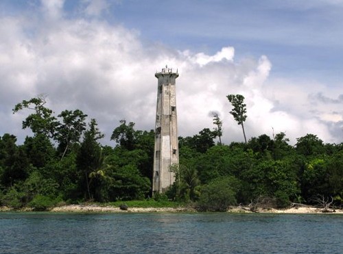 Pulau Boo Besar Light, Raja Ampat Islands, July 2009 ex-Panoramio photo copyright muhajir3012; used by permission |
|
|  Tanjung Warangket Light, Pulau Salawati, January 2010 ex-Panoramio photo copyright muhajir3012; used by permission |
|
| 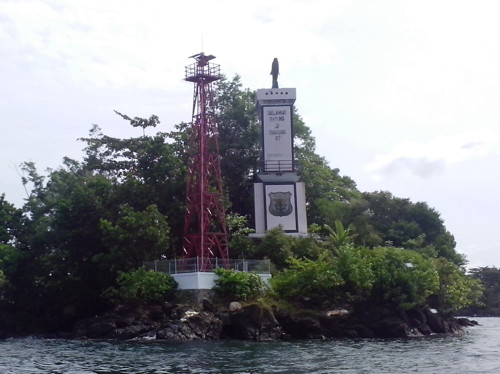 Pulau Dofior Light, Sorong, March 2014 ex-Panoramio photo copyright Richard Monny; used by permission |
|
|  Tanjung Memori Light, Manokwari, January 2011 ex-Panoramio photo copyright David Worabay; used by permission |
Lighthouses of Indonesia: Papua Province North Coast
| Indonesia has been independent since 1945 after having been the Dutch East Indies for more than 350 years. It is a huge country, stretching along both sides of the Equator for more than 46 degrees of longitude (roughly 5100 km or 3200 miles). Comprised of some 17,000 islands (more than 6000 inhabited islands), it has hundreds of major aids to navigation. The lighthouses on this page are in Indonesian Papua (western New Guinea). The Dutch extended their claim to western New Guinea, the world's second-largest island, in 1828, but they established no major settlements until nearly 1900. The western half of the island remained under Dutch control until 1963, when it was ceded to Indonesia. Most of the Indonesian half of the island is included in Papua Province. West Papua Province includes the oddly-shaped Doberai or Bird's Head (Vogelkop) Peninsula at the northwestern corner of New Guinea. This page includes the lighthouses of the north coast of Papua Province, and there are separate pages for West Papua Province and Papua Province South Coast. The Indonesian word for a lighthouse is mercusuar. The phrase menara suar, which includes the Arabic word menara, is sometimes used instead. Tanjung and ujung are words for capes, pulau is an island, selat is a strait, karang is a reef, and teluk is a gulf, bay, or harbor. Aids to navigation in Indonesia are operated and maintained by the Directorate General of Sea Navigation. ARLHS numbers are from the ARLHS World List of Lights. Admiralty numbers are from volumes F and Q of the Admiralty List of Lights & Fog Signals. U.S. NGA List numbers are from Publications 111 and 112.
|  Oinake Light, Jayapura Regency, November 2007 Flickr photo copyright Billy Gabriel; used by permission |
- Supiori Regency: Mapia Atoll Lighthouses
- Note: The Mapia atoll (Kepulauan Mapia) is located far out in the Pacific, about 200 km (125 mi) north of Manokwari. These islands represent the northeasternmost extension of Indonesian territory. In the 19th century the atoll was claimed by Spain as part of the Caroline Islands. After the Spanish-American War in 1898 Spain sold its Caroline Islands colony to Germany but the treaty failed to include Mapia in its definition of the territory. This gave the Netherlands the opportunity to assert its own claim and add the islands to the Dutch East Indies; thus they were inherited by Indonesia. A small settlement on Pulau Bras supports Indonesia's coast guard and border control station.
- Pulau Fanildo
- 2007. Active; focal plane 33 m (108 ft); two white flashes every 12 s. 30 m (98 ft) skeletal tower. Two 1-story station buildings. No photo available but Google has a satellite view of the station. The lighthouse marks the northwestern corner of the Mapia atoll. Accessible only by boat. Site status unknown. Admiralty F2111.98.
- Pulau Bras
- 2007. Active; focal plane 45 m (148 ft); two white flashes every 12 s. 40 m (131 ft) square skeletal tower with lantern and gallery mounted atop the coast guard and border patrol station. Tower painted white, lantern red. A photo is available and Google has a satellite view of the station. This new lighthouse marks the northeastern corner of the Mapia atoll. Accessible only by boat. Site status unknown. Admiralty F2111.95.
- Pulau Pegun
- Date unknown. Active; focal plane 30 m (98 ft); white flash every 5 s. 30 m (98 ft) skeletal tower. Several 1-story station buildings. No photo available but Google has a satellite view of the station. Both NGA and ARLHS have placed the light erroneously in Palau. Located on the southern tip of Pulau Pegun, marking the southern end of the Mapia atoll. Accessible only by boat. Site status unknown. ARLHS PAL-002; Admiralty F2111.9; NGA 111-10932.
Supiori Regency: Pulau Supiori Area Lighthouses- Note: The Biak Islands (known under Dutch rule as the Schouten Islands) are spread across the entrance to the Cenderawasih Bay above the "neck" of the Bird's Head Peninsula. Supiori, Biak, and Numfor are the largest of the islands. The islands were all included in the Biak Numfor Regency until 2004, when Supiori and nearby islands were split off as the separate Supiori Regency.
- Pulau Bepondi
- Date unknown. Active; focal plane 23 m (75 ft); white flash every 5 s. Approx. 20 m (66 ft) square white skeletal tower. Four 1-story station buildings. No photo available. Bing's satellite view actually shows two towers at the station. Pulau Bepondi is a small island about 30 km (19 mi) northwest of the large island of Pulau Biak and 160 km (100 mi) northeast of Manokwari. Located at or near the southwestern corner of the island. Site status unknown. Admiralty Q3391.5; NGA 26053.
- Pulau Bepondi North
- Date unknown. Active; focal plane 33 m (108 ft); two white flashes every 12 s. 30 m (98 ft) "white beacon," possibly a concrete tower. No photo available and the lighthouse may be too new to appear in Google's satellite view. Located on the northern tip of the island. Accessible only by boat. Site status unknown. Admiralty Q3391.7.
- Teluk Wabudori
- Date unknown. Active; focal plane about 14 m (46 ft); green light, characteristic unknown. Approx. 14 m (46 ft) round barbell-shaped green fiberglass tower mounted on a platform supported by piles. No photo available but Google has a satellite view. Located on the west side of the entrance to the sheltered harbor of Wabudori (formerly Jenggerbun) on the north coast of Pulau Supiori. Accessible only by boat. Site open, tower closed. Admiralty Q3392.75; NGA 26055.
- Teluk Korido
- Date unknown. Active; focal plane about 15 m (49 ft); light characteristic unknown. Approx. 15 m (49 ft) square pyramidal skeletal tower mounted on a platform supported by piles. Barce Rumkabu's sunset photo is at right and Google has a satellite view. Located a short distance off the pier at Korido, on the south coast of Pulau Supiori. Accessible only by boat. Site open, tower closed. Admiralty Q3392.73.
Biak Numfor Regency Lighthouses- Pulau Rasi
- Date unknown. Active; focal plane 14 m (43 ft); three white flashes every 15 s. 13 m (43 ft) skeletal tower, painted white. No photo available but Bing has an indistinct satellite view. Located on a small island at the southeastern end of the Biak Islands. Accessible only by boat. Site status unknown. Admiralty Q3393.6; NGA 26088.
- Tanjung Basari (Pulau Miosmboi)
- Date unknown. Active; focal plane 16 m (52 ft); white light, 2 s on, 6 s off. Approx. 15 m (49 ft) square white skeletal tower. No photo available but Google has an indistinct satellite view. Located on a rocky reef just off the eastern tip of Pulau Biak. Accessible only by boat but easy to see from the beach. Site open, tower closed. Admiralty Q3392.8; NGA 26058.
- Sorido Outer Range Front (2?)
- Date unknown. Active; focal plane 15 m (49 ft) (?); white light, 1 s on, 1 s off. 10 m (33 ft) (?) square skeletal tower painted white. No photo available but Google has an indistinct satellite view. The tower appears to be higher than the listed height. The rear light is on a mast. Located on the beach near the Biak Island airport, east of Kota Biak on the south side of Pulau Biak. Site status unknown. Admiralty Q3393; NGA 26060.
- Sorido Inner Range Front (2?)
- Date unknown. Active; focal plane 17 m (56 ft) (?); white light, 4 s on, 4 s off. 10 m (33 ft) (?) square skeletal tower painted white. Ronni Berotabui has a distant street view and Google has a satellite view. The tower appears to be higher than the listed height. Located on the west end of the main quay at Kota Biak. Site status unknown. Admiralty Q3393.3; NGA 26068.
- Sorido Inner Range Rear (2?)
- Date unknown. Active; focal plane 17 m (56 ft) (?); white light, 4 s on, 4 s off. 15 m (49 ft) (?) square skeletal tower painted white. No photo available but Google has a satellite view. The tower appears to be higher than the listed height. Located 240 m (262 yd) west northwest of the front light. Site status unknown. Admiralty Q3393.31; NGA 26072.
- Pulau Rani
- Date unknown. Active; focal plane 17 m (56 ft); white flash every 3 s. 15 m (49 ft) square skeletal tower, painted white. No photo available but Google has a satellite view. Located on a small island off the southwestern coast of Pulau Biak. Site status unknown. Admiralty Q3392.7; NGA 26056.
- Pulau Numfor (Yerunana)
- Date unknown. Active; focal plane 45 m (148 ft); white flash every 5 s. 16 m (52 ft) skeletal tower, painted white. No photo available but Google has a satellite view. Pulau Numfor is an island about 25 km (15 mi) in diameter in the northwestern corner of the Cenderawasih Gulf. Located near Kameri on the northwestern side of the island, about 65 km (40 mi) east of Manokwari. Site status unknown. ARLHS IDO-179; Admiralty Q3392; NGA 26052.
Nabire Regency Lighthouses- Pulau Kabuai (Kubuai) (2)
- 2010 (?). Active; focal plane 33 m (108 ft); white flash every 5 s. 30 m (98 ft) skeletal tower, painted white. No photo available but Bing has a satellite view. NGA formerly listed a light with a 14 m (46 ft) focal plane. Located on a tiny islet in the southwestern Cenderawasih Gulf. Accessible only by boat. Site status unknown. Admiralty Q3395.4; NGA 26107.
- Ujung Kimbo (Teluk Kimi, Nabire)
- Date unknown. Active; focal plane 23 m (75 ft); two white flashes every 8 s. 20 m (66 ft) skeletal tower, painted white. The light is in the upper right corner of Arief Hidayat's aerial photo of the port and Google has a satellite view. Located on a headland sheltering the harbor of Nabire, the regency capital on the east side of the Cenderawasih Gulf. Site status unknown. Admiralty Q3395.8; NGA 26104.
- Pulau Jaunan
- Date unknown. Active; focal plane 20 m (66 ft); white flash every 5 s. 20 m (66 ft) skeletal tower, painted white. Raimond Rumatray has a drone view of visitors atop the tower and Google has a good satellite view. The Admiralty and NGA list the light as "Nabire," although it is 32 km (20 mi) north of that town. Located on a small island, the westernmost in a group of islands. Accessible only by boat. Site status unknown. Admiralty Q3395.6; NGA 26100.
Yapen Islands Regency Lighthouses- Note: Pulau Yapen is an island about 170 km (105 mi) long but only about 25 km (15 mi) at its widest; it lies east to west across the northeastern Cenderawasih Bay southeast of Pulau Biak.
- Tanjung Rainbawi (Tanjung Rainbawa)
- Date unknown. Active; focal plane 26 m (85 ft); white flash every 3 s. 20 m (66 ft) skeletal tower, painted white. No photo available but Google has an indistinct satellite view. The lighthouse may have been replaced recently, since NGA formerly listed a 16 m (52 ft) tower. Located at the eastern tip of the island of Yapen, marking the east entrance to the Cenderawasih Gulf. Site status unknown. ARLHS IDO-322; Admiralty Q3393.7; NGA 26108.
- * Serui (2)
- 2009(?). Active; focal plane 17 m (56 ft); white flash every 3 s. 15 m (49 ft) square pyramidal skeletal tower, painted white. A photo is at right, Ikal Ichwan has a twilight photo, M. Andi has a view from the sea, and Google has a satellite view. Indonesian Wikipedia has a photo of the former light. Serui is the principal town on Pulau Yapen. Located at the head of a short pier on the waterfront of Serui, on the south side of Pulau Yapen. Accessible by walking the pier. Site open, tower closed. Admiralty Q3394.5; NGA 26084.
- Serui Pertamina
- Date unknown. Active; focal plane about 10 m (33 ft); white light, pattern unknown. Approx. 8 m (26 ft) square tower mounted on four robust piles. A photo is available and Google has a satellite view. Located at the foot of the pier at the Pertamina oil terminal on the west side of Serui. Site and tower closed. Admiralty Q3394.
- Tanjung Woka (2?)
- Date unknown. Active; focal plane 40 m (131 ft); white flash every 3 s. 10 m (33 ft) (?) square skeletal tower with gallery, painted white. No photo available but Bing has a satellite view. The tower appears to be taller than the 10 m listed by NGA. Located on the west end of Pulau Yapen. Accessible only by boat. Site status unknown. Admiralty Q3395; NGA 26096.
Waropen Regency Lighthouses- Note: Waropen Regency is the mainland region on the east coast of Cenderawasih Bay across from Pulau Yapen
- Tanjung Kamengsenu
- Date unknown. Active; focal plane 53 m (174 ft); white flash every 4 s. Approx. 40 m (131 ft) square tapered skeletal tower with gallery, painted white. Two small station buildings. No photo available but Google has a satellite view of the station. Located on a prominent cape on the east side of the Cenderawasih Gulf. Site status unknown. Admiralty K3395.9; NGA 26104.5.
- Pulau Naufi (Pulau Nau)
- Date unknown. Active; focal plane 35 m (115 ft); one long white flash every 10 s. Described by NGA only as a beacon, this is probably a skeletal tower. No photo available but Google has a satellite view that probably shows the light to the right of a monument. Located at the northern tip of an island off the east coast of the Cenderawasih Gulf. Accessible only by boat. Site status unknown. Admiralty Q3396; NGA 26105.
- * Tanjung Worisanua (Pelabuhan Waropen)
- Date unknown. Active; focal plane 23 m (75 ft); white flash every 6 s. Approx. 20 m (66 ft) square white skeletal tower. No photo available but Google has a satellite view. Located just west of the piers at Waropen. Site open, tower closed. Admiralty Q3396.2; NGA 26105.5.
- Mamberamo (Cape D'Urville)
- Date unknown. Active; focal plane 31 m (102 ft); white flash every 5 s. 16 m (52 ft) skeletal tower, painted white. No photo available but Google has a satellite view. Located on the east side of the entrance to the Mamberamo River about 3 km (2 mi) southwest of Tanjung Perkam (Cape D'Urville), the northwestern "shoulder" of New Guinea. Site status unknown. Admiralty Q3396.6; NGA 26112.
Sarmi Regency (Philippine Sea) Lighthouses- Pulau Liki (Kumamba Liki)
- Date unknown. Active; focal plane 45 m (141 ft); one long white flash every 5 s. 40 m (131 ft) skeletal tower, painted white. Four 1-story coast guard station buildings. No photo available but Google has a satellite view of the station. Located on the northern tip of Pulau Liki, about 40 km (25 mi) north of Sarmi. Accessible only by boat. Site status unknown. ARLHS IDO-210; Admiralty Q3396.8; NGA 26092.
- Pulau Armo (Pulau Nirumoar)
- Date unknown. Active; focal plane 16 m (52 ft); six quick white flashes and one long white flash every 15 s. 16 m (52 ft) post with gallery mounted on a square platform supported by piles. No photo available but Google has a satellite view. Located on a reef at the southern end of Pulau Nirumoar, an island about 10 km (6 mi) southeast of Pulau Liki. Accessible only by boat. Site status unknown. Admiralty Q3396.9; NGA 26115.
- Sarmi (2)
- Date unknown. Active; focal plane 32 m (105 ft); white flash every 5 s. 16 m (52 ft) skeletal tower, painted white. No photo available but Google has a satellite view. This light recently replaced a much shorter tower. Located on a promontory near Sarmi, about 140 km (225 mi) west northwest of Jayapura. Site status unknown. Admiralty Q3397; NGA 26116.
- * Pelabuhan Sarmi
- Date unknown. Active; focal plane about 25 m (82 ft); white light, pattern unknown. Approx. 22 m (72 ft) octagonal white concrete tower. Tom Ramand has an April 2017 photo (also seen at right), and Eragon Black has an October 2017 street view, but the tower is too new to appear in Google's satellite view. Located on the waterfront at Sarmi. Site open, tower closed. Not listed by the Admiralty.
- Pulau Yamna (Jamna)
- Date unknown. Active; focal plane 23 m (75 ft); white flash every 6 s. No description and no photo available but Bing has an indistinct satellite view that may show the lighthouse. Located on Pulau Yamna, an island about 50 km (30 mi) east of Sarmi. Accessible only by boat. Site status unknown. Admiralty Q3397.6; NGA 26118.
Jayapura Regency (Philippine Sea) Lighthouses- Note: Jayapura, the capital of Papua Province, is a city of more than 300,000 people. Known as Hollandia under Dutch control, it was recaptured from Japanese occupation by an Alled amphibious invasion in April 1944.
- Tanjung Kamdara (Kamadara)
- Date unknown. Active; focal plane 43 m (141 ft); white light, 5 s on, 5 s off. Approx. 40 m (131 ft) octagonal white concrete tower with lantern and gallery. Several coast guard station buildings. Stevanus Rumbino has a 2018 photo, Steve Christiantara has a 2014 photo and Google has a satellite view. Located on a promontory about 120 km (75 ft) west of Jayapura. Site open, tower closed. Admiralty Q3397.8; NGA 26119.
- Tanjung Kelapa (Tanjung Ormu)
- Date unknown. Active; focal plane 12 m (39 ft); white flash every 6 s. 10 m (33 ft) square skeletal tower. No photo available but Google has a satellite view. The area is accessible only by boat. Located on a promontory about 50 km (30 mi) west of Tanjung Suaja. Site status unknown. Admiralty Q3397.95; NGA 26119.5.
- Tanjung Suaja (Soeadja Moko)
- Date unknown. Active; focal plane 215 m (705 ft); three white flashes every 24 s. 20 m (66 ft) white concrete tower. Keeper's houses and other station buildings. No photo available but Google has a good satellite view. Tanjung Suaja is a mountainous promontory that shelters the approach to Jayapura, about 4 km (2.5 mi) east of the city. Located atop the mountain, but accessible by road. Site status unknown. ARLHS IDO-281; Admiralty Q3398; NGA 26120.
- * Jayapura Entrance North
- Date unknown. Active; focal plane 13 m (43 ft); green flash every 5 s. 13 m (43 ft) round hourglass-shaped green tower, mounted on a square concrete platform supported by concrete piles. Ralph Sanderson's photo is at right, he has a second photo taken from the other side of the bay, and Google has a satellite view. Jayapura, known as Hollandia under Dutch rule, has a beautiful semicircular harbor framed by mountains. Located just offshore near the Swiss-Belhotel Papua, marking the north side of the entrance to the harbor. Accessible only by boat. Site status unknown. Admiralty Q3398.8; NGA 26123.5.
- Noebai Nan Range Front
- Date unknown. Active; focal plane 17 m (56 ft); quick-flashing white light. 15 m (49 ft) square skeletal tower, painted white and carrying a triangular slatted daymark, point up. The tower is at the far left in Arief Rachman Ashar's photo of the harbor and Google has an indistinct satellite view. Located near the south end of the waterfront in Jayapura. Site status unknown. Admiralty Q3399; NGA 26124.
- * Noebai Nan Range Rear
- Date unknown. Active; focal plane 22 m (72 ft); white light occulting once every 4 s. 20 m (66 ft) square skeletal tower, painted white and carrying a triangular slatted daymark, point down. Richard Monny's photo is at right but the tower is inconspicuous in Google's satellite view. Located near the Bank of Papua in downtown Jayapura, 150 m (165 yd) west of the front light. Site open, tower closed. Admiralty Q3399.1; NGA 26128.
- * Jayapura Harbor
- 2013. Active; focal plane 38 m (125 ft); white flash every 5 s. 30 m (98 ft) square skeletal tower with gallery, painted white. Asmatriadi Anwar has a view across the harbor and Google has a satellite view. Located on Batu Putih Street on the south side of Jayapura Harbor. Site open, tower closed. Admiralty Q3399.5.
- Jayapura Entrance South (Hollandia Baai)
- Date unknown. Active; focal plane 13 m (43 ft); red flash every 4 s. 13 m (43 ft) round hourglass-shaped red tower, mounted on a square concrete platform supported by concrete piles. No photo available but Google has a satellite view. Located on a shoal marking the south side of the entrance to Jayapura harbor. Accessible only by boat. Site status unknown. Admiralty Q3398.9; NGA 26123.
- * Oinake
- Date unknown (1990s?). Active; focal plane 200 m (656 ft); white flash every 10 s. Approx. 37 m (121 ft) octagonal concrete tower with lantern and gallery. The lighthouse is unpainted white concrete. Billy Gabriel's photo is at the top of this page, Ian Uzumaki has a 2018 photo, Ashley Zoch has a 1999 photo, and Google has a good satellite view. This lighthouse is located at the border between Indonesian Papua and the independent nation of Papua New Guinea, near the town of Watung, Papua New Guinea, and about 50 km (30 mi) east of Jayapura, the capital of Indonesia's Papua province. Argananta Yuwana has a street view taken at the border crossing. Accessible by road. Site open, tower closed. Admiralty Q3399.8; NGA 26129.
|
|  Teluk Korido Light, Pulau Supiori, September 2015 Flickr photo copyright Barce Rumkabu; permission requested |
|
|  Serui Light, Serui, May 2010 ex-Panoramio photo copyright danank.ar.io; permission requested |
|
|  Pelabuhan Sarmi Light, Sarmi, April 2017 Google Maps photo by Tom Ramand |
|
|  Jayapura Entrance North Light, Jayapura, March 2007 Flickr photo copyright Ralph Sanderson; used by permission |
|
|  Noebai Nan Range Rear Light, Jayapura, December 2015 ex-Panoramio photo copyright Richard Monny; used by permission |
Lighthouses of Indonesia: Papua Province South Coast
| Indonesia has been independent since 1945 after having been the Dutch East Indies for more than 350 years. It is a huge country, stretching along both sides of the Equator for more than 46 degrees of longitude (roughly 5100 km or 3200 miles). Comprised of some 17,000 islands (more than 6000 inhabited islands), it has hundreds of major aids to navigation. The lighthouses on this page are in Indonesian Papua (western New Guinea). The Dutch extended their claim to western New Guinea, the world's second-largest island, in 1828, but they established no major settlements until nearly 1900. The western half of the island remained under Dutch control until 1963, when it was ceded to Indonesia. Most of the Indonesian half of the island is included in Papua Province. West Papua Province includes the oddly-shaped Doberai or Bird's Head (Vogelkop) Peninsula at the northwestern corner of New Guinea. This page includes the lighthouses of the south coast of Papua Province and there are separate pages for West Papua Province and Papua Province North Coast. The Indonesian word for a lighthouse is mercusuar. The phrase menara suar, which includes the Arabic word menara, is sometimes used instead. Tanjung and ujung are words for capes, pulau is an island, selat is a strait, karang is a reef, teluk is a gulf or bay, and pelabuhan is a port. Aids to navigation in Indonesia are operated and maintained by the Directorate General of Sea Navigation. ARLHS numbers are from the ARLHS World List of Lights. Admiralty numbers are from volumes F and Q of the Admiralty List of Lights & Fog Signals. U.S. NGA List numbers are from Publications 111 and 112.
|  Tanjung Mimiabe Light, Merauke, November 2008 Panoramio photo copyright T. Palgunadi; used by permission |
- Merauke Regency Lighthouses
Note: A town founded by the Dutch in 1902, Merauke has a population of about 90,000 and is the principal settlement on Papua Province's south coast. The town would be the capital of the proposed South Papua Province. - Sungai Torasi (Torasi River) Entrance
- Date unknown. Active; focal plane 14 m (46 ft); white flash every 3 s. 14 m (46 ft) square skeletal tower with gallery, painted white and mounted on a platform supported by piles. No photo available but Google has a satellite view. Located just off the east side of the mouth of the Torasi River, within a few meters of the Papua New Guinea border. Accessible only by boat. Site open, tower closed. Admiralty Q3336; NGA 25887.
- Sungai Torasi (Torasi River)
- Date unknown. Active; focal plane 44 m (144 ft); two white flashes every 10 s. Approx. 30 m (98 ft) square skeletal tower with lantern and gallery, painted white, mounted atop a border patrol building. John Davidson's is at right and Google has a satellite view. Located on the west side of the mouth of the Torasi River. Accessible only by boat. Site open, tower closed. Admiralty Q3335.
- Tanpa Nama Island
- Date unknown. Active; focal plane about 14 m (46 ft); light characteristic unknown. Approx. 14 m (46 ft) square skeletal tower with gallery, painted white and mounted on a platform supported by piles. No photo available but Bing has a satellite view. Located on a shoal (not an island) about 11 km (6.5 mi) southwest of the mouth of the Torasi River. Accessible only by boat. Site open, tower closed. Admiralty Q3333.
- * Merauke (Tanjung Mimiabe) (3)
- 2007(?) (station established 1905). Active; focal plane 44 m (144 ft); four white flashes every 20 s. 40 m (131 ft) tapered square skeletal tower with gallery, painted white. T. Palgunadi's excellent closeup photo is at the top of this page and Google has a satellite view. This is the landfall light for Merauke. The original lighthouse was located at the mouth of the Merau River about 4 km (2.5 mi) northwest of the present station. NGA formerly listed a 20 m (66 ft) skeletal tower; the 40 m tower was announced by the Admiralty in 2007. Located on the oceanfront about 3 km (2 mi) southwest of downtown Merauke. Site open, tower closed. ARLHS IDO-316; Admiralty Q3338; NGA 25888.
- Sungai Merauke (Merau River)
- Date unknown. Active; focal plane 13 m (43 ft); red flash every 3 s. 13 m (43 ft) tower mounted on a square platform supported by piles. No photo available, but Bing has a satellite view. The light marks the beginning of the channel leading to Merauke. Located about 3 km (2 mi) off the mouth of the Merau River. Accessible only by boat. Site open, tower closed. Admiralty Q3338.4; NGA 25897.5.
- Merauke Inner
- Date unknown. Active; focal plane 13 m (43 ft); green flash every 5 s. 13 m (43 ft) square pyramidal skeletal tower, painted green and mounted on a square platform supported by piles. No photo available but Google has a satellite view. Located about 600 m (0.37 mi) off the east side of the entrance to the Merau River estuary. Accessible only by boat. Site open, tower closed. Admiralty Q3338.7; NGA 25899.
- Merauke Range Front
- Date unknown. Active; focal plane 14 m (46 ft); white flash every 4 s. 9 m (30 ft) square cylindrical skeletal tower with gallery, painted white and mounted on a square concrete base. The tower also carries a triangular slatted daymark, point up. No photo available but Google has a satellite view. This is the entrance range for the Merau River estuary leading to the port of Merauke. Located on the west side of the entrance to the estuary. Site status unknown. Admiralty Q3339; NGA 25892.
- Merauke Range Rear
- Date unknown. Active; focal plane 21 m (69 ft); white flash every 3 s. 16 m (52 ft) square cylindrical skeletal tower with gallery, painted white. The tower also carries a triangular slatted daymark, point down. No photo available but Google has a satellite view. Located on the north side of the estuary about 3.5 km (2 mi) northwest of the town and 300 m (330 yd) northeast of the front light. Site status unknown. ARLHS IDO-169; Admiralty Q3339.1; NGA 25896.
- * Pelabuhan Merauke
- Date unknown. Active; focal plane 25 m (82 ft); white flash every 6 s. 25 m (82 ft) square skeletal tower, mounted on a square platform supported by piles. Lighthouse painted white. Liuzz Sulo Junior has a view of the light, the tower is visible in Brawijaya Mandiri's aerial photo of Merauke and Google has a satellite view. Located in the Merau River estuary adjacent to the docks at Merauke. Easily seen from the waterfront. Site open, tower closed. ARLHS IDO-284; Admiralty Q3339.2; NGA 25890.
- Yatum (Matara) (?)
- Date unknown. Active; focal plane 25 m (82 ft); white flash every 6 s. 25 m (82 ft) iron skeletal tower, probably with lantern and gallery, painted white. No photo available. It is not clear that this light exists. If it does, then there is a Google satellite view showing an odd 4-legged tower that may carry the light; another satellite view is a second possible location. Located near the beachfront at Matara, about 10 km (6 mi) north of Merauke. Site status unknown. ARLHS IDO-355; Admiralty Q3339.6; NGA 25900.
- Tanjung Mawal
- Date unknown. Active; focal plane 13 m (43 ft); white flash every 3 s. 13 m (43 ft) concrete post with gallery mounted on a square concrete pier supported by piles. Entire lighthouse is white. No photo available but Bing has a satellite view. Located off a river entrance about 80 km (50 mi) northwest of Merauke. Accessible only by boat. Site open, tower closed. Admiralty Q3339.8; NGA 25902.
- Pulau Habee (2?)
- Date unknown. Active; focal plane 35 m (115 ft); white flash every 4 s. Approx. 30 m (98 ft) square skeletal tower with gallert, painted white. No photo available, but a visitor has several views from the top of the tower and Bing has a satellite view. NGA lists an 8 m (26 ft) tower for this location, but has the higher focal plane. Located on an island about 8 km (5 mi) off the coast southeast of Gelib. Accessible only by boat. Site open, and apparently the tower can be climbed. Admiralty Q3340; NGA 25904.
- Selat Muli
- Date unknown. Active; focal plane 14 m (46 ft); green flash every 3 s. 14 m (46 ft) round hourglass-shaped fiberglass tower. Entire lighthouse is green. No photo available but Bing has a satellite view. Selat Muli (Muli Strait) is a narrow waterway separating the large Dolok (Kimaan) Island, about 165 km (100 mi) west of Merauke. Located on the east side of the entrance to the strait. Accessible only by boat. Site open, tower closed. Admiralty Q3340.51; NGA 25906.1.
- Kimaan
- Date unknown. Active; focal plane 23 m (75 ft); white flash every 6 s. Approx. 20 m (66 ft) skeletal tower, mounted on a square equipment building. No photo available but Google has a satellite view. Located at the base of the town pier at Kimaan, a settlement on Dolok (Kimaan) Island on the west side of the Muli Strait. Site open, tower closed. ARLHS IDO-148; Admiralty Q3340.52; NGA 25906.3.
- Waan (Wan)
- 2009. Active (?); focal plane 45 m (148 ft); two white flashes every 12 s. Approx. 42 m (138 ft) square skeletal tower with lantern and gallery mounted on a square tower atop a coast guard station. Rafael Kapura's photo is at right, amateur radio operators have a more distant view (halfway down the page), and Google has a satellite view. Located at Waan, a small settlement near the southwestern tip of Dolok (Kimaan) Island. Site open, tower closed. Not listed by the Admiralty.
Mappi Regency Lighthouses- Sungai Digul (Ujung Digul, Digul River)
- Date unknown. Active; focal plane 12 m (39 ft); white light, 1 s on, 1 s off. 12 m (39 ft) square white skeletal tower mounted on a platform supported by piles. No photo available and the tower is not seen in Bing's satellite view. Located at the entrance to the estuary of the Digul River about 30 km (19 mi) north of Dolok Island. Accessible only by boat. Site open, tower closed. Admiralty Q3340.7; NGA 25907.
- Ujung Lumpur (Modderhock)
- Date unknown. Active; focal plane 13 m (43 ft); green flash every 4 s. 13 m (43 ft) round hourglass-shaped fiberglass tower. Entire lighthouse is green. No photo available but Google has a satellite view. Located about 3 km (2 mi) offshore on the south side of the Digul River estuary entrance. Accessible only by boat. Site open, tower closed. Admiralty Q3340.68; NGA 25907.2.
- Habeeaman
- Date unknown. Active; focal plane 14 m (46 ft); green flash every 5 s. 14 m (46 ft) "beacon.". Entire lighthouse is green. No photo available but Google has a distant satellite view. Located on the south side of the Digul River channel about 35 km (22 mi) east of the Ujung Lumpur light. Accessible only by boat. Site open, tower closed. Admiralty Q3340.67; NGA 25907.15.
Asmat Regency Lighthouses- Birufu (Kampung River)
- Date unknown. Active; focal plane 13 m (43 ft); green flash every 3 s. 13 m (43 ft) round hourglass-shaped fiberglass tower. Entire lighthouse is green. No photo available but Bing has a satellite view. Located on the south side of the Kampung River estuary entrance about 50 km (30 mi) southeast of Agats. Accessible only by boat. Site open, tower closed. Admiralty Q3340.95; NGA 25907.3.
- Sungai Utumbuwe (Agats)
- Date unknown. Active; focal plane 23 m (75 ft); white flash every 3 s. 23 m (75 ft) square white skeletal tower mounted on a platform supported by piles. A photo is at right, and Ojhon Belite has a 2017 photo, but the tower is not seen in Bing's satellite view of the waterfront. Located on the south side of the Asewets (Utumbuwe) River estuary in the regency capital of Agats on the southwest coast of Papua. Site open, tower closed. Admiralty Q3340.87; NGA 25907.62.
- Teluk Flamingo
- 2015. Active; focal plane 25 m (82 ft); white flash every 4 s. 20 m (66 ft) square skeletal tower, painted white. No photo available but Bing has a distant satellite view. Located on the north side of the entrance to the Asewets River estuary. Site open, tower closed. Admiralty Q3340.92.
- Pulau Laag
- 2009. Active; focal plane 42 m (138 ft); two white flashes every 10 s. No photo available, and the tower is probably too new to appear in Google's satellite view of the listed location. Apparently located on a shoal or platform off a swampy promontory about 50 km (30 mi) west of Agats. Accessible only by boat. Site open, tower closed. Admiralty Q3340.98.
Mimika Regency Lighthouse- Sungai Keakwa (Nime)
- Date unknown. Active; focal plane 16 m (52 ft); two white flashes every 12.5 s. 15 m (49 ft) skeletal tower, painted white. No photo available, and the tower has not been found in Google's satellite view of the area. Located at Keakwa, near the western border of Papua Province. Site status unknown. Admiralty Q3343; NGA 25908.
|
|

|
|
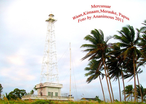
|
|  Agats Light, Agats, March 2018 photo copyright 'I Made Genta' courtesy of Indri Juwono; used by permission |
No comments:
Post a Comment