
http://www.unc.edu/~rowlett/lighthouse/idri.htm
Lighthouses of Indonesia: Sulawesi (Celebes)
| Indonesia has been independent since 1945, after having been the Dutch East Indies for more than 350 years. It is a huge country, stretching along both sides of the Equator for more than 46 degrees of longitude (roughly 5100 km or 3200 miles). Comprised of some 17,000 islands (more than 6000 inhabited islands), it has hundreds of major aids to navigation. This page includes the lighthouses of Sulawesi (Celebes), a major island in the northern part of the country. Shaped like an artistically drawn letter K, Sulawesi consists mostly of four narrow peninsulas. The Makassar Strait separates Sulawesi from Kalimantan (Borneo) to the west. The Celebes Sea is north of the island, the Banda Sea is to the east and southeast, and the Flores Sea is on the south. Makassar, also called Ujung Pandang, is the major port. The Indonesian word for a lighthouse is mercusuar. The phrase menara suar, which includes the Arabic word menara, is sometimes used instead. Pulauis an island and karang is a reef. Aids to navigation in Indonesia are operated and maintained by the Indonesian Directorate of Marine Navigation (Indomarinav). ARLHS numbers are from the ARLHS World List of Lights. Admiralty numbers are from volumes F and K of the Admiralty List of Lights & Fog Signals. U.S. NGA List numbers are from Publication 112.
|

South Sulawesi Province Lighthouses
- Southern Peninsula Lighthouses
- Tanjung Lameriki
- Date unknown. Active; focal plane 34 m (112 ft); white flash every 10 s. 30 m (98 ft) "white beacon," according to NGA. No photo available, and Google has only a fuzzy satellite view of the area. This lighthouse faces the Gulf of Boni, an arm of the Flores Sea that separates the southern and southeastern peninsulas of Sulawesi. Located on a promontory about 45 km (28 mi) north of Macoppe. Site status unknown. ARLHS IDO-306; Admiralty K1541.3; NGA 25473.
- Bulukumba (Tanjung Papanambeja) (2)
- Date unknown (station established 1904). Active; focal plane 26 m (85 ft); four white flashes every 20 s. 24 m (79 ft) skeletal tower, painted white. No photo available, but a Google satellite view probably shows the shadow of the lighthouse. The original tower had a height of 13 m (43 ft). Located on a promontory on the southwest side of Bulukumba. Site status unknown. ARLHS IDO-121; Admiralty K1532; NGA 25412.
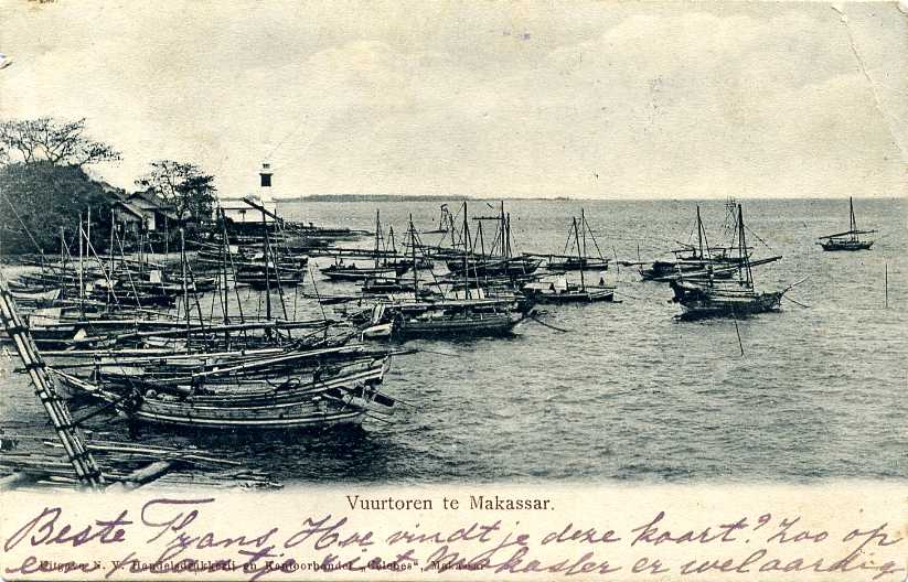
- #Mariso (Tanjung Bunga) (2)
- Date unknown (station established 1887). Inactive since 2007. 39 m (128 ft) painted white. No photo available, and a Google satellite view of the area does not reveal the tower. The original lighthouse had a focal plane of 14 m (46 ft). Development plans for this area may have caused the lighthouse to be demolished. Located on or near the beach a short distance south of Makassar. Site status unknown. Admiralty K1516; NGA 25440.
Selayer Islands Lighthouses
Note: The Selayer Islands extend south and then southeast from the southeastern tip of Sulawesi's Southern Peninsula. The islands separate the Flores Sea to the east from the Java Sea to the west.
Pulau Pasitanete (Pamatata) (2)- Date unknown (station established 1905). Active; focal plane 65 m (213 ft); four white flashes every 20 s. 20 m (66 ft) square skeletal tower with lantern and gallery. Lighthouse painted white, lantern red. A photo is available, and Google has a satellite view of the station. The original lighthouse had a focal plane height of only 45 m (148 ft), so it must have been built at a lower location. Located on a small island off the northern end of the much larger island of Selayar, about 30 km (19 mi) southeast of Bulukumba. Accessible only by boat. Site status unknown. ARLHS IDO-234; Admiralty K1536; NGA 25408.
- Pulau Bonerate
- Date unknown. Active; focal plane 64 m (210 ft); three white flashes every 10 s. 30 m (98 ft) tower, probably skeletal. No photo available, and Google has only a very distant satellite view of the area. Located on an island in the Flores Sea near the southeastern end of the Selayer group. Site status unknown. Admiralty K1328; NGA 25663.
- Java Sea Island Lighthouses
Pulau Banawaya (2) - Date unknown (station established 1913). Active; focal plane 32 m (105 ft); two white lights every 5 s. Approx. 27 m (89 ft) "white beacon." No photo available, and Google has only a very distant satellite view of the area. KITLV has a distant view of the original lighthouse, which had a focal plane height of 20 m (66 ft). Located on a small island in the middle of the Java Sea about 150 km (90 mi) south of the southern point of Sulawesi. Accessible only by boat. Site status unknown. ARLHS IDO-009; Admiralty K1325; NGA 25416.5.
- Pulau Kapoposangbali
- Date unknown. Active; focal plane 34 m (112 ft); white flash every 10 s. 30 m (98 ft) "white beacon," according to NGA. No photo available; Google has a very distant satellite view of the island. Located on a small island of the Satengar group, far across the Java Sea, roughly 360 km (225 mi) southwest of Makassar and only 80 km (50 mi) off the north coast of Lombok in the Lesser Sunda Islands. Accessible only by boat. Site status unknown. ARLHS IDO-203; Admiralty K1322; NGA 25578.
- Pulau Jailamu (2?)
- Date unknown. Active; focal plane 17 m (56 ft); white flash every 5 s. NGA describes this as a 10 m (33 ft) fiberglass tower, but two very distant views (first and second photos on the page) suggest a taller, possibly skeletal tower. Google has a very distant satellite view of the island. Located on a small island about 210 km (130 mi) south southwest of Makassar. Accessible only by boat. Site status unknown. Admiralty K1325.3; NGA 25416.6.
- Karang Takarewataya (De Bril, Den Bril)
- 1887. Active; focal plane 25 m (82 ft); white flash every 10 s. 23 m (75 ft) octagonal cast iron tower with lantern and three galleries, painted with red and white horizontal stripes. Damien Loong's photo is at the top of this page, KITLV has a 1931 photo, and the Amsterdam Tropenmuseum has a 1929 distant view. Google has a distant satellite view of the reef. This is the only survivor among several lighthouses of this class built in the Dutch Indies. Located at the south end of a reef in the Java Sea about 120 km (75 mi) south southwest of the southern point of Sulawesi. Accessible only by boat; fishing tours to the reef are available. Site status unknown. ARLHS IDO-009; Admiralty K1524; NGA 25416.
Southern Strait of Makassar Lighthouses- Dewakang Besar
- Date unknown. Active; focal plane 33 m (108 ft); white flash every 5 s. 30 m (98 ft) white iron skeletal tower. No photo available, and Google has only a distant satellite view of the island. Located on a small island about 105 km (65 mi) west southwest of Makassar. Accessible only by boat. Site status unknown. ARLHS IDO-125; Admiralty K1522; NGA 25420.
- Pulau Tanakeke
- Date unknown. Active; focal plane 24 m (79 ft); white flash every 10 s. 20 m (66 ft) white concrete tower. No photo available, but Google has a good satellite view. Pulau Tanakeke is a populated island about 15 km (9 mi) southwest of Patalasang, on the southwestern tip of Sulawesi. ARLHS IDO-250; Admiralty K1518.5; NGA 25421.
- Pulau Dayangdayangan (2)
- Date unknown (station established 1906). Active; focal plane 42 m (138 ft); white flash every 5 s. 30 m (98 ft) white iron skeletal tower. No photo available, and Google has only a fuzzy satellite view of the island. The original lighthouse had a focal plane height of 32 m (105 ft). Located on a small island about 50 km (30 mi) south southwest of Makassar. Accessible only by boat. Site status unknown. ARLHS IDO-196; Admiralty K1518; NGA 25424.
- Kudingareng (Kodengarang) Lompo
- Date unknown. Active; focal plane 41 m (135 ft); four white flashes every 27 s. 40 m (131 ft) square skeletal tower with lantern and gallery, painted white. A small photo is available (3/4 the way down the page), and Google has an indistinct satellite view. Located at the south end of a small but densely populated island about 15 km (9 mi) west of Makassar. Accessible only by boat. Site status unknown. ARLHS IDO-023; Admiralty K1518; NGA 25432.
- Pulau Lanyukang
- Date unknown. Active; focal plane 24 m (79 ft); white flash every 10 s. 20 m (66 ft) "white beacon," according to NGA. No photo available, and the island is only a blur in Google's satellite view. Located on an islet about 40 km (25 mi) northwest of Makassar. Accessible only by boat. Site status unknown. Admiralty K1508.5; NGA 25461.
- Pulau Kapoposang (1)
- 1906. Inactive since 1957. Approx. 25 m (82 ft) cast iron tower with lantern and gallery, painted white. Andika Ferial's photo at right shows this historic Dutch lighthouse and its modern replacement, but the island is only a blur in Google's satellite view. This important light station marks the westernmost of a large group of islands and reefs in the southeastern quadrant of the Makassar Strait. Site open, tower closed.
- Pulau Kapoposang (2)
- 1957 (station established 1906). Active; focal plane 36 m (118 ft); white flash every 5 s. 33 m (108 ft) skeletal tower with lantern and gallery, painted red (?). Andika Ferial has a distant photo, and S. Budiarto has a very distant photo. Kapoposang is a popular destination for scuba divers. Located on an island in the Makassar Strait, about 100 km (60 mi) northwest of Makassar in southwestern Sulawesi. Accessible only by boat. Site open, tower closed. ARLHS IDO-022; Admiralty K1508; NGA 25468.

West Sulawesi Province Lighthouses
- Central Strait of Makassar Lighthouses
Tanjung Rangasa - Date unknown. Active; focal plane 105 m (344 ft); white flash every 5 s. 21 m (69 ft) white iron skeletal tower. No photo available, and Google has only a very distant satellite view of the cape. Located on a prominent cape about 5 km (3 mi) southwest of Majene (Madjene). Site status unknown. ARLHS IDO-325; Admiralty K1496; NGA 25492.
- Tanjung Binanga
- Date unknown. Active; focal plane 24 m (79 ft); white flash every 6 s. Approx. 20 m (66 ft) square pyramidal skeletal tower, painted white. No photo available, but Google has a satellite view. Located on a promontory at Palangpalang, about 40 km (25 mi) north of Majene (Madjene). Site probably open, tower closed. Admiralty K1494; NGA 25494.
- Tanjung Rangas
- Date unknown. Active; focal plane 99 m (325 ft); white flash every 6 s. 21 m (69 ft) white iron skeletal tower. No photo available, and Google has only a very distant satellite view of the cape. Located on a prominent cape about 10 km (6 mi) northwest of Mamuju. Site status unknown. ARLHS IDO-324; Admiralty K1490; NGA 25500.
- Tanjung Pasangkayu (Pasaugkajoe)
- Date unknown. Active; focal plane 56 m (184 ft); three white flashes every 24 s. 37 m (131 ft) skeletal tower with lantern and gallery, painted white. No photo available, and Google has only a distant satellite viewof the cape. Located on a promontory about 2.5 km (1.5 mi) west of Pasangkayu. Site status unknown. ARLHS IDO-044; Admiralty K1484; NGA 25504.
Central Sulawesi Province West Coast Lighthouses
- Northern Strait of Makassar Lighthouses
- * Teluk Palu (Palu Gulf)
- 1907. Active; focal plane 82 m (269 ft); four long (2 s) white flashes every 25 s. 21 m (69 ft) octagonal (?) white iron skeletal tower with lantern and gallery. No photo available, but Google has a good satellite viewof the station. It appears that the original lighthouse survives here. Located on a prominent cape on the west side of the entrance to the narrow Palu Gulf, about 25 km (15 mi) northwesr of Palu, the capital of Central Sulawesi. Site status unknown, but it should be possible to drive to this station from Palu. ARLHS IDO-339; Admiralty K1476; NGA 25508.
- Pulau Manimbaya
- Date unknown. Active; focal plane 50 m (164 ft); two white flashes every 20 s. 40 m (131 ft) square skeletal tower, painted white. No photo available, and Google has only a distant satellite view of the area. This lighthouse is built almost precisely on the Equator. Located at the tip of a long promontory extending into the Strait of Makassar about 30 km (19 mi) northwest of Mapaga. Site status unknown. Admiralty F2040; NGA 25114.
- Pulau Tuguan (Pulau Tugguan, Noordwachter)
- 1902. Active; focal plane 92 m (302 ft); white flash every 5 s. 20 m (66 ft) white iron skeletal tower. The modern description is consistent with the Dutch original. No photo available, and Google has only a distantsatellite view of the island. Not to be confused with another, better known Noordwachter in the Java Sea. Located on an island in the strait about 25 m (15 mi) northwest of Munte in northwestern Sulawesi. Accessible only by boat. Site status unknown. ARLHS IDO-031; Admiralty F2044; NGA 25120.
- Tanjung Labuan Dedeh
- Date unknown. Active; focal plane 16 m (52 ft); white flash every 3 s. 15 m (49 ft) skeletal tower, painted white. No photo available, and Google has only a distant satellite view of the point. Located on a point of land sheltering the harbor of Tolitoli. Site status unknown. Admiralty F2048; NGA 25116.
- Tanjung Malagka (Pulau Salando Timur, Stroomenkaap) (2)
- Date unknown (station established 1913). Active; focal plane 57 m (187 ft); white flash every 5 s. 25 m (82 ft) white iron skeletal tower. No photo available, but Google has a satellite view. This lighthouse marks the northeastern entrance to the Strait of Makassar. The original lighthouse had a focal plane height of 46 m (151 ft). Located on an island just off Tanjung (cape) Malagka, the northwestern corner of Sulawesi. Accessible only by boat. Site status unknown. ARLHS IDO-312; Admiralty F2050; NGA 25112.
- Pulau Dolongan
- Date unknown. Active; focal plane 23 m (75 ft); white flash every 6 s. 15 m (49 ft) "white beacon." No photo available. Located off the northern tip of an island about 10 km (6 mi) northeast of Tanjung Malagka. Site status unknown. Admiralty F2051.
North Sulawesi Province Lighthouses
- Note: North Sulawesi Province includes the final third of the sinuous Minahasa Peninsula plus the Sangihe (Sangir) Islands, a chain that stretches north across the Celebes Sea almost to Mindanao in the Philippines.
Minahasa Peninsula Lighthouses - Pulau Hulawa
- Date unknown. Active; focal plane 40 m (131 ft); white flash every 3 s. 25 m (82 ft) skeletal tower, painted white. No photo available; a distant Google satellite view probably shows the location of the station. Located on an island off the north coast of Sulawesi, about 25 km (15 mi) north of Malingkapoto. Accessible only by boat. Site status unknown. Admiralty F2060; NGA 25128.
- Pulau Manterawu
- 2006. Active; focal plane 50 m (164 ft); two white flashes every 10 s. 40 m (131 ft) "white tower," probably skeletal. No photo available. Located on an island about 30 km (19 mi) west of Tanjung Arus. Accessible only by boat. Site status unknown. Admiralty F2070.5.
- Tanjung Arus (Pulau Talisei, Talise)
- Date unknown (station established 1910). Active; focal plane 108 m (354 ft); white flash every 5 s. 20 m (66 ft) white iron skeletal tower. No photo available, and Google has only a distant satellite view of the area. KITLV has a 1913 photo of the original lighthouse, an octagonal pyramidal skeletal tower with lantern and gallery. This lighthouse may still be standing. Tanjung Arus is the extreme northeastern tip of Sulawesi, at the end of the Minahasa Peninsula. The lighthouse is not on the cape, but on the northern tip of Pulau Talisei (Talise), an island off the cape, about 50 km (30 mi) northeast of Manado. Accessible only by boat. Site status unknown. ARLHS IDO-290; Admiralty F2072; NGA 25156.
- Batukapal (Batu Kapal)
- Date unknown. Active; focal plane 35 m (115 ft); white flash every 4 s. Approx. 9 m (30 ft) round hourglass-shaped white concrete tower. A 2006 photois available, and Google has a satellite view. Pulau Lembeh is a long, narrow island off the east side of Tanjung Arus. This light is atop a steep rocky islet off the northeastern tip of Pulau Lembeh, about 20 km (13 mi) northeast of Kota Bitung. Accessible only by boat. Site status unknown. NGA 25157.
- Lilang
- Date unknown. Active; focal plane 70 m (230 ft); white flash every 3 s. 30 m (98 ft) skeletal tower with gallery, painted white. No photo available, and the tower is not seen in Google's indistinct satellite view. Located at Lilang, on the east coast of the Minahasa Peninsula about 30 km (19 mi) southeast of Manado. Site status unknown. ARLHS IDO-159; Admiralty F2079.6; NGA 25168.
- Pulau Pardana
- Date unknown (station established 1912). Active; focal plane 73 m (240 ft); white flash every 4 s. 22 m (72 ft) skeletal tower, painted white. James Arjuna's photo is at right, but Google has only a fuzzy satellite view of the island. Located on a small island just offshore on the northern entrance to the Gulf of Tomini from the Molucca Sea. Accessible only by boat. Site status unknown. ARLHS IDO-233; Admiralty F2082; NGA 25228.
Northeastern Sangihe Islands Lighthouses- Pulau Miangas (Isla Palmas) (2?)
- Date unknown. Active; focal plane 130 m (427 ft); three white flashes every 20 s. 30 m (98 ft) square skeletal tower with gallery, painted white. A portfolio of photos is available; this collection suggests that the present tower is relatively new. The tower is visible in David Vilabella's distant view of the island, but Google's satellite view is only a blur. Pulau Miangas is a small island in the Philippine Sea about 125 km (75 mi) east of the southern tip of Mindanao. The island, known as Isla Palmas in the Philippines, was claimed by the U.S. as part of the Philippines in the early 1900s, but in 1928 the Permanent Court of Arbitration ruled in favor of the Netherlands. Indonesia maintains sovereignty as successor to the Dutch. Located at the highest point of the island. Site open, tower closed. Admiralty F2138; NGA 15156.
- Pulau Marampit
- 2006. Active; focal plane 45 m (148 ft); two white flashes every 12 s. 40 m (131 ft) "white tower," probably skeletal. No photo available, and Google has only a very distant satellite view of the area. Located at the northern tip of an island about 10 km (6 mi) northeast of Keratung. Site status unknown. Admiralty F2134.2.
- * [Karatung]
- Date unknown. Active; focal plane 12 m (39 ft); white flash every 3 s. 10 m (33 ft) round hourglass-shaped white fiberglass tower, mounted on a square concrete base. Ferdi Rosman Feizal has a photo, but Google has only a very distant satellite view. This light is similar to many harbor lights in Indonesia's out islands. Pulau Karatung is a small but inhabited island about 50 km (30 mi) northeast of the northern tip of Pulau Talaud. Accessible only by boat. Site status unknown. Admiralty F2134; NGA 25199.
- Pulau Kakarutan (Kakorotan)
- Date unknown. Active; focal plane 45 m (148 ft); two white flashes every 10 s. 30 m (98 ft) tower, probably skeletal. Google has only a very fuzzy satellite view of the island. Located on a small island a few miles east of Pulau Intata (next entry). Accessible only by boat. Site status unknown. Admiralty F2133.8.
- Pulau Intata
- Date unknown (2006 or later). Active; focal plane 55 m (180 ft); two white flashes every 10 s. 30 m (98 ft) skeletal tower, painted white. No photo available, and Ferdi Rosman Feizal's early 2006 photo of the island does not show a lighthouse. Located on a small island about 50 km (30 mi) east northeast of the northern tip of Pulau Talaud. Accessible only by boat. Site status unknown. Admiralty F2133.9.
- Tanjung Palle
- Date unknown. Active; focal plane 65 m (213 ft); white flash every 10 s. 40 m (131 ft) "white beacon." No photo available; Google has a very distant satellite view of the cape. Located on Pulau Kaburuang, an island off a promontory at the south end of the Talaud group in the northeastern Sangihe chain. Site status unknown. ARLHS IDO-318; Admiralty F2133.5; NGA 25197.8.
Northwestern Sangihe Islands Lighthouses
- Pulau Marore
- Date unknown. Active; focal plane 180 m (591 ft); two white flashes every 10 s. 40 m (131 ft) square skeletal tower with lantern and gallery, painted white. Ferdi Rosman Feizal has a distant view and second view, but Google has only a distant satellite view of the island. Pulau Marore is the Indonesia's northernmost inhabited island in the Celebes Sea. Located about 90 km (55 mi) south of Mindanao. Accessible only by boat. Site status unknown. Admiralty F2135; NGA 25200.
- Pulau Kawio
- 2006. Active; focal plane 50 m (164 ft); two white flashes every 10 s. 30 m (98 ft) "white beacon," probably skeletal. No photo available. Located on a small island about 150 km (95 mi) south of Mindanao. Accessible only by boat. Site status unknown. Admiralty F2134.8.
- Pulau Matutuang
- Date unknown. Active; focal plane 107 m (351 ft); white flash every 5 s. "White lighthouse," according to NGA. No photo available, and Google has only a distant satellite view of the island. Located on an isolated high island at the northern end of the Sangihe chain, about 130 km (80 mi) south of Mindanao. Accessible only by boat. Site status unknown. ARLHS IDO-220; Admiralty F2135.5; NGA 25201.
Pulau Sangihe Area Lighthouses
Pulau Buang (Salehe)- Date unknown. Active; focal plane 80 m (262 ft); two white flashes every 10 s. Approx. 30 m (98 ft) skeletal tower, painted white. The lighthouse is a ghostly presence in Ferdi Rosman Feizal's distant view of the island, and also in a second view. The island is only a blur in Google's satellite view. Located on an island about 35 km (22 mi) northeast of the northern point of Pulau Sangihe, the central island of the archipelago. Accessible only by boat. Site status unknown. Admiralty F2128; NGA 25197.
- Pulau Manipa
- Date unknown. Active; focal plane 69 m (226 ft); white flash every 10 s. 30 m (98 ft) white concrete tower with lantern and gallery. David Vilabella has a distant view from the sea, but Google has only a distantsatellite view of the area. Located on the southern tip of a small island off the north end of Pulau Sangihe. Site status unknown. ARLHS IDO-218; Admiralty F2127.5; NGA 25196.5.
- Tanjung Bunakeng (Tahuna, Pulau Sangihe)
- Date unknown. Active; focal plane 130 m (427 ft); white flash every 3 s. 30 m (98 ft) skeletal tower, painted white. No photo available, and Google has only a very fuzzy satellite view of the area. Located on heights near Tahuna, the principal town on the west coast of Pulau Sangihe. Site status unknown. Admiralty F2123; NGA 25190.
Southern Sangihe Islands Lighthouses
Pulau Makalehi- Date unknown. Active; focal plane 150 m (492 ft); two white flashes every 10 s. 40 m (131 ft) "white tower," probably skeletal. No photo available. Located on a high island about 25 km (15 mi) west of Pulau Siau, one of the larger islands of the Sangihe chain. Accessible only by boat. Site status unknown. Admiralty F2120.3.
- * [Ulu (Pulau Siau)]
- Date unknown. Active; focal plane 15 m (49 ft); white flash every 3 s. 13 m (43 ft) round hourglass-shaped white fiberglass tower, mounted on a square concrete base. Ferdi Rosman Feizal has a photo, but Google has only a very distant satellite view of the town. This light is similar to many harbor lights in Indonesia's out islands. Located on the waterfront of Ulu, a settlement on the east coast of Pulau Siau. Site open, tower closed. Admiralty F2120; NGA 25184.
- Pulau Pasige
- Date unknown. Active; focal plane 15 m (49 ft); white flash every 2.5 s. 15 m (49 ft) skeletal tower, painted white. No photo available, and Google has only a distant satellite view of the island. Located on a small island near the south end of the Sangihe chain, about 90 km (55 mi) north northeast of Tanjung Arus. Accessible only by boat. Site status unknown. Admiralty F2114; NGA 25176.

Central Sulawesi Province East Coast Lighthouses
- Banda Sea Lighthouses
Tanjung Kembani - Date unknown. Active; focal plane 22 m (72 ft); white flash every 10 s. 20 m (66 ft) "white beacon," probably a skeletal tower. No photo available, and Google has only a distant satellite view of the area. Located on the southern tip of Peleng, largest and westernmost of the Banggai island group, off the southeast coast of Sulawesi's eastern peninsula. Site status unknown. Admiralty K1565; NGA 25274.3.
- Pulau Buangbuang (Buang Buang)
- Date unknown. Active; focal plane 28 m (92 ft); white flash every 5 s. 25 m (82 ft) "white tower," probably skeletal. No photo available, and Google's satellite view of the area is fuzzy and clouded. Located on a small island at the southeastern tip of the Banggai group, marking a narrow passage between the Banggai reefs and those of the Sula group in North Maluku province. Accessible only by boat. Site status unknown. Admiralty K1569; NGA 25380.
- Tanjung Bea
- Date unknown. Active; focal plane 18 m (56 ft); white flash every 5 s. 15 m (49 ft) skeletal tower, painted white. No photo available, and Google has only a distant satellite view of this very remote area. Located on a promontory near the base of Sulawesi's eastern peninsula, near Morowali. Site status unknown. Admiralty K1563.5; NGA 25268.
- Tanjung Losoni
- Date unknown. Active; focal plane 50 m (164 ft); four white flashes every 10 s. "White lighthouse," according to NGA. No photo available, and Google has only a distant satellite view of the area. This light stands on a promontory at Losoni on the central east coast of Sulawesi. Site status unknown. ARLHS IDO-311; Admiralty K1562.93; NGA 25274.6.
Southeast Sulawesi Province Lighthouses
- Kendari and Pulau Wowoni Area Lighthouses
Pulau Dehaan - 2007. Active; focal plane 55 m (180 ft); four white flashes every 10 s. 10 m (33 ft) white concrete tower. No photo available. NGA lists an earlier light with a focal plane of 12 m (39 ft). Located on a small island about 65 km (40 mi) north of Kendari. Site status unknown. Admiralty K1559.97.
- Pulau Saponda Tengah (2)
- Date unknown. Active; focal plane 17 m (56 ft); white flash every 4 s. 18 m (59 ft) "white beacon," probably a skeletal tower. No photo available; Google has a very distant satellite view of the island. NGA lists an earlier light with a focal plane of 12 m (39 ft). Located on a small island about 20 km (13 mi) east of Kendari. Site status unknown. Admiralty K1559; NGA 25280.
- Tanjung Pemali (Pulau Wowoni)
- Date unknown. Active; focal plane 45 m (148 ft); four white flashes every 20 s. 40 m (131 ft) square skeletal tower, painted white. No photo available, but Google has a satellite view. Located on the northern tip of the island of Wowoni, southeast of Kendari. Site status unknown. Admiralty K1559.7; NGA 25288.
- Tanjung Watutembatu
- Date unknown. Active; focal plane 65 m (213 ft); four white flashes every 10 s. 40 m (131 ft) skeletal tower, painted white. No photo available, and Google has only a very distant satellite view of the cape. This light stands on a promontory at the easternmost tip of the island of Wowoni, southeast of Kendari. Site status unknown. ARLHS IDO-334; Admiralty K1559.9; NGA 25289.
Pulau Buton and Flores Sea Island Lighthouses
Tanjung Kanolanatumbi- Date unknown. Active; focal plane 45 m (148 ft); white flash every 10 s. 30 m (98 ft) white concrete tower with lantern and gallery. No photo available, but Google has a satellite view. This light stands on the eastern point of the island of Buton, off the southeast coast of Sulawesi. Site status unknown. ARLHS IDO-302; Admiralty K1555.8; NGA 25346.
- Pulau Wangiwangi
- Date unknown (station established 1904). Active; focal plane 150 m (492 ft); two white flashes every 12 s. 21 m (69 ft) skeletal tower, painted white. No photo available, and Google has only a distant satellite viewof the area. Pulau Wangiwangi is an island in the Tukangbesi group, east of Buton. Located on the northern tip of the island, 35 km (22 mi) east of Tanjung Kanolanatumbi. Site status unknown. ARLHS IDO-259; Admiralty K1558; NGA 25348.
- Pulau Binongko
- Date unknown. Active; focal plane 45 m (148 ft); white flash every 10 s. "White beacon," according to NGA. A tall tower would be expected here to guide vessels rounding the southeastern tip of Sulawesi and its associated islands. No photo available, and Google has only a distant satellite view of the area. Located at the southern tip of Pulau Binongko, the southernmost island of the Tukangbesi group, southeast of Buton. Site status unknown. Admiralty K1558.34; NGA 25350.4.
- Pulau Moromaho
- Date unknown. Active; focal plane 45 m (148 ft); four white flashes every 10 s. "Lighthouse," according to NGA. A distant photo (a little more than halfway down the page) shows what appears to be a white concrete tower perhaps 40 m (131 ft) tall. Google has a distant satellite view of the island. Located on a small island at the junction of the Banda and Flores Seas well off the southeast coast of Sulawesi. The island is a well known scuba diving site. Accessible only by boat. Site open, tower closed. ARLHS IDO-225; Admiralty K1558.33; NGA 25351.
- Pulau Lebutan
- Date unknown. Active; focal plane 20 m (66 ft); two white flashes every 8 s. 15 m (49 ft) skeletal tower, painted white. No photo available; Google has a distant and clouded satellite view of the area. Located on an island in the channel on the west side of Butan. Accessible only by boat. Site status unknown. ARLHS IDO-154; Admiralty K1551.5; NGA 25328.
- Tanjung Masige (Pulau Siumpu)
- Date unknown. Active; focal plane 20 m (66 ft); white flash every 5 s. 15 m (49 ft) skeletal tower, painted white. No photo available, and Google has only a fuzzy satellite view of the area. Located at the southwestern tip of Pulau Siumpu, an island off the southwestern tip of Butan. Site status unknown. ARLHS IDO-280; Admiralty K1553; NGA 25352.
Kolaka Area Lighthouses
* Kolaka Pier (2)- Date unknown. Active; focal plane 17 m (56 ft); yellow flash every 3 s. 15 m (49 ft) white concrete tower. No photo available, but Google has a satellite view. Kolaka is a town on the Gulf of Boni, which separates Southeast and South Sulawesi. Ferries cross the gulf from Kolaka to Watampone in South Sulawesi. Located on the east pier at Kolaka. Site status unknown, but there must be good views from the waterfront. Admiralty K1547.9; NGA 25360.
- Lambacina (Lambasina) Kecil
- Date unknown. Active; focal plane 60 m (197 ft); two white flashes every 8 s. 30 m (98 ft) white tower, probably skeletal. No photo available, and Google has only a distant satellite view of the island. Located on a small island in the Gulf of Boni about 30 km (19 mi) west of Kolaka. Accessible only by boat. Site status unknown. Admiralty K1548.6; NGA 25370.
Information available on lost lighthouses:
- Fort Rotterdam (1861-1930s), Makassar. KITLV has a historic photo, the Netherlands Archives has a closeup historic photo, Wikimedia has four historic photos from the Amsterdam Tropenmuseum, and Klaus Huelse has a postcard view.
Notable faux lighthouses:
No comments:
Post a Comment