
http://www.unc.edu/~rowlett/lighthouse/idri.htm
Lighthouses of Indonesia: Java and Madura
| Indonesia has been independent since 1945, after having been the Dutch East Indies for more than 350 years. It is a huge country, stretching along both sides of the Equator for more than 46 degrees of longitude (roughly 5100 km or 3200 miles). Comprised of some 17,000 islands (more than 6000 inhabited islands), it has hundreds of major aids to navigation. Unfortunately, we have no idea how many of these aids can be considered lighthouses. Information about them is scarce, and photos are even scarcer. Official light lists contain dozens of entries for "framework towers" and "white beacons," providing little guidance for the lighthouse fan. The island of Java (Jawa in Indonesian) is the heart of the country and home to 62% of the population. In fact, with more than 130 million residents it is the world's most populous island. This page is not complete. Listed here are towers at locations known to be historic Dutch light stations, plus some additional sites at which there is some evidence for a lighthouse. Added to this is an appeal for more information and photos; if you know about lighthouses in Indonesia, please share that knowledge. The Indonesian word for a lighthouse is mercusuar or (in two words) mercu suar. The phrase menara suar, which includes the Arabic word menara, is sometimes used instead. Tanjung and ujung are words for capes, pulau is an island, selat is a strait, karang is a reef, and teluk is a harbor. The original Dutch names of historic lighthouses, if known, are shown in curly brackets {}. Aids to navigation in Indonesia are operated and maintained by the Indonesian Directorate of Marine Navigation (Indomarinav). ARLHS numbers are from the ARLHS World List of Lights. Admiralty numbers are from volumes F and K of the Admiralty List of Lights & Fog Signals. U.S. NGA List numbers are from Publication 112.
|  Edam (Pulau Damar) Light, Jakarta, August 2007 photo copyright Deni Adam Malik; permission requested |
- Banten Province (West Java) Lighthouses
- Tanjung Layar (Ujung Kulon, First Point) {Eerste Punt} (4)
- Date unknown (station established 1877). Active; focal plane 50 m (164 ft); three white flashes every 15 s. 30 m (98 ft) square tapered metal framework tower, painted white. A photo, a closeup, and a view from the sea are available, and Google has a satellite view of the station. This lighthouse, the fourth at the station, is at the extreme southwest tip of Java, marking the east side of the entrance to the Sunda Strait from the Indian Ocean. KITLV has a raredrawing of the first lighthouse, a tall cast iron tower. This handsome structure was severely damaged by an earthquake on 1 September 1880, after only three years of service. It was replaced by a brick tower seen in a second KITLV image, a Tropenmuseum photo, and an 1886 French book (halfway down the page) posted by the Cornell Digital Library. There is a report (see halfway down the page) that foundations of this lighthouse remain. In 1906 the brick lighthouse was replaced (for reasons unknown) by a skeletal tower seen in a 1926 Tropenmuseum photo, a 1940 KITLV photo and also in a 1950 photo. The present lighthouse is staffed by crews rotating every four months. The area is included in the Ujung Kulon National Park. Located at the extreme tip of the point. Accessible only by boat. Site open, tower closed. ARLHS IDO-084; Admiralty K1050.2; NGA 23332.
- *** Cikoneng (Tjikoneng, Anyer, Fourth Point) {Vierde Punt} (2)
- 1885 (station established 1855). Active; focal plane 60 m (197 ft); two white flashes every 20 s. 58 m (190 ft) round cast iron tower with lantern and gallery. Entire lighthouse painted white. A photo appears at right, Unian Husien has a 2010 photo, closeup, a second closeup, and a more distant view are available, the Triopenmuseum has three historic photos, and KITLV has a historic photo taken in 1914. This is one the very few Indonesian lighthouses readily accessible to tourists. The original lighthouse was destroyed by tsunami waves triggered by the catastrophic explosion of the Krakatoa volcano on 27 August 1883. These waves were at least 30 m (100 ft) high, obliterating all traces of the original light station. Located on Tanjung Cikoneng near Anyer Kidul on the east shore of Sunda Strait, overlooking the still-active Krakatoa. Accessible by road. Site open, tower open for climbing. ARLHS IDO-081; Admiralty K1050; NGA 23336.
- Pulau Tampurung (Toppers Island, Button Island) (2)
- Date unknown (station established 1919). Active; focal plane 77 m (253 ft); white flash every 3 s. Approx. 30 m (98 ft) square skeletal tower with lantern and gallery, painted white. The light can be seen in Hadi Kusmana's distant photo of the island (click on the photo for an enlargement), and Google has asatellite view. Pulau Tampurung is a small but very high island in the northern entrance to the Sunda Strait, about 10 km (6 mi) northwest of Merak. Located on the highest point of the island. Accessible only by boat. Site status unknown. Admiralty K1052; NGA 23344.
- Pulau Tunda (Babi Island) (2)
- Date unknown (station established 1890). Active; focal plane 32 m (105 ft); one long white flash every 6 s. 30 m (98 ft) skeletal tower, painted white. No photo available, and Google has only a distant satellite viewof the island. KITLV has a 1914 photo of the original lighthouse. This light and the Payung Besar light below guide vessels between the Sunda Strait and Jakarta. Pulau Tunda is a narrow island about 4.5 km (3 mi) long and about 25 km (15 mi) east of the Sunda Strait entrance. Located at the eastern end of the island. Accessible only by boat. Site status unknown. ARLHS IDO-256; Admiralty K1054; NGA 23360.
- * Karang Antu
- Date unknown. Active; focal plane 13 m (43 ft); white flash every 5 s. 12 m (39 ft) round hourglass-shaped white concrete tower. Zulkifli Faiz has a photo, and Google has a satellite view. Located on the west side of the harbor entrance at Kasemen. Site open, tower closed. Admiralty K1055; NGA 23362.
Seribu Islands Lighthouses
Note: The Seribu Islands (or Thousand Islands) are a chain of small islands extending north from near Jakarta into the Java Sea. Many of the islands are protected within a marine national park, but several have resort developments. The islands are administered as part of the Capital Territory of Jakarta.- Pulau Payung Besar (Big Umbrella Island) (2)
- Date unknown (station established 1890). Active; focal plane 32 m (105 ft); two white flashes every 10 s. 30 m (98 ft) skeletal tower, painted white. A photo is available, and Google has a good satellite view. KITLV has a 1914 photo of the original lighthouse, which was similar but not identical to the present light. Located on a small island about 32 km (20 mi) east of Pulau Tunda and 90 km (55 mi) northwest of Jakarta. Accessible only by boat. Site status unknown. ARLHS IDO-236; Admiralty K1058; NGA 23364.
- Jaga Utara (Pulau Sebira, Pulau Seribu, North Watcher) {Noord Wachter}
- 1869. Active; focal plane 48.5 m (159 ft); two white flashes every 11 s. 48 m (157 ft) 16-sided cast iron skeletal tower with lantern, gallery, central cylinder, and a 1-story keeper's house enclosed in the base. Lighthouse painted white. Tommy Bernardus has an excellent closeup photo, several distant views are available, and Michael Thirnbeck has an aerial photo, but the island is only a blur in Google's satellite view. This is the oldest surviving Dutch lighthouse in Indonesia. Located on the northernmost island of the chain of the Seribu chain, about 65 km (40 mi) east of the Sumatran coast and 130 km (80 mi) north northwest of Jakarta. Accessible only by boat. Site status unknown. ARLHS IDO-062; Admiralty K1042; NGA 23376.
- Pulau Peniki (South Watcher) {Zuid Wachter}
- Date unknown. Active; focal plane 32 m (105 ft); white flash every 5 s. 35 m (115 ft) square skeletal tower with lantern and gallery, painted white. Several photos are available, but the island is only a blur in Google's satellite view. This light greets vessels bound for Jakarta from Singapore. Located on a small island in the Java Sea about 90 km (55 mi) north northwest of Jakarta. Accessible only by boat. Site status unknown. ARLHS IDO-236; Admiralty K1060.5; NGA 23372.
Jakarta Lighthouses- Pulau Damar Besar {Edam}
- 1881. Active; focal plane 55 m (180 ft); four white flashes every 20 s. 50 m (164 ft) 16(?)-sided cast iron tower with lantern and gallery. Entire lighthouse painted white. Deni Adam Malik's photo is at the top of this page, a portfolio of photos and another photo are available, and Google has a fuzzy satellite view. Staffed by a crew of five. This lighthouse is located on Pulau Damar Besar in the center of the entrance to the bay of Jakarta. Accessible only by boat, but apparently boats can be chartered in Jakarta. ARLHS IDO-061; Admiralty K1062; NGA 23404.
- Sunda Kelapa Harbor West (2)
- Date unknown. Active; focal plane about 17 m (56 ft); two green flashes every 6 s. 17 m (56 ft) round hourglass-shaped tower, painted green. Bill Strong has a photo, and Google has a satellite view. This light replaced a much shorter light listed by NGA. Located at the end of the west breakwater of the harbor. Accessible only by boat. Site open, tower closed. Admiralty K1069.4; NGA 23412.
- Sunda Kelapa Harbor East (2)
- Date unknown. Active; focal plane about 17 m (56 ft); two red flashes every 6 s. 17 m (56 ft) round hourglass-shaped tower, painted red. Suharwan has a photo, Augusto Sunga has a photo of the lighthouse in silhouette, and Google has a satellite view. This light replaced a much shorter light listed by NGA. Located at the end of the west breakwater of the harbor. Accessible only by boat. Site open, tower closed. Admiralty K1069; NGA 23408.
- Jakarta {Batavia} West Mole
- 1862. Active; focal plane 17 m (56 ft); red flash every 3 s. 16 m (52 ft) round stone tower, painted white. KITLV has two historic photos, a closeupand a more distant view, the Tropenmusuem also has historic photos, Huelse has a historic postcard view, and Google has a satellite view. This lighthouse is now immediately adjacent to the Jakarta Fish Port, which is under development by Japanese investors. As part of the redevelopment, the lighthouse is to be refurbished; a sketch of the intended results appears at right. We do not know the status of this planned restoration. Located on the east side of the mole, about 1200 m (3/4 mi) south of Kelapa Harbor lights. Site status unknown. ARLHS IDO-063; Admiralty K1068.5; NGA 23416.
- Tanjung Priok (Tipar) Inner Harbor
- Date unknown (station established 1885). Active; focal plane 46 m (151 ft); white flash every 10 s. 40 m (131 ft) skeletal tower, painted white. No photo available, but a Google satellite view probably shows the shadow of the tower. Located near the harbor at Tipar, in east Jakarta. Site status unknown. Admiralty K1073.5; NGA 23428.
West Java Province North Coast Lighthouses
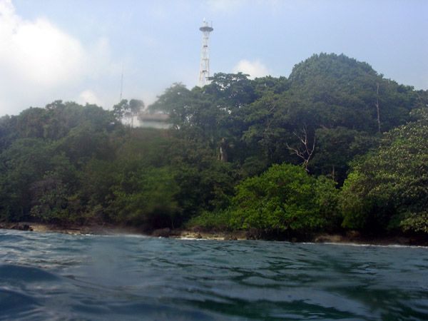
Pulau Biawak (Pulau Rakit) {Boompjes Eiland}- 1911 (station established 1872). Active; focal plane 54 m (177 ft); white flash every 15 s. 50 m (164 ft) 16-sided cast iron skeletal tower with lantern, gallery, and central cylinder. Although listed by NGA as black and white, the lighthouse is now painted all white. An excellent photo, another photo , and a view from the sea are available, and Google has a fuzzy satellite view. Located on a small island about 65 km (40 mi) northeast of Kandanghaur in the Java Sea. Site status unknown. ARLHS IDO-074; Admiralty K1084; NGA 23460.
- * Cirebon (2)
- Date unknown (station established 1867). Active; focal plane 31 m (102 ft); three white flashes every 20 s. 30 m (98 ft) round skeletal tower with lantern and gallery, painted white. Nancy Kie Sheng has a goodphoto, and Google has a satellite view. KITLV has a 1902 photo of the original lighthouse. Located on the mole on the east side of inner harbor at Cirebon. Site open, tower closed. ARLHS IDO-123; Admiralty K1092; NGA 23476.
Central Java Province North Coast Lighthouses
Ujung Brebes- Date unknown. Active; focal plane 22 m (72 ft); white flash every 4 s. 20 m (66 ft) square skeletal tower with lantern and gallery, painted white. No photo available, but Google has a satellite view. Ujung Brebes is a "cape" formed by sedimentation along the mouth of a river; continued sedimentation has pushed the point of land 1.2 km (3/4 mi) north of the lighthouse. Located 12 km (7.5 mi) north northwest of Bredes. Site status unknown. ARLHS IDO-348; Admiralty K1101; NGA 23502.
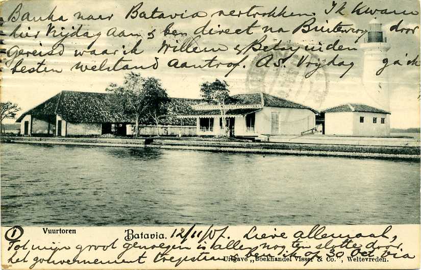
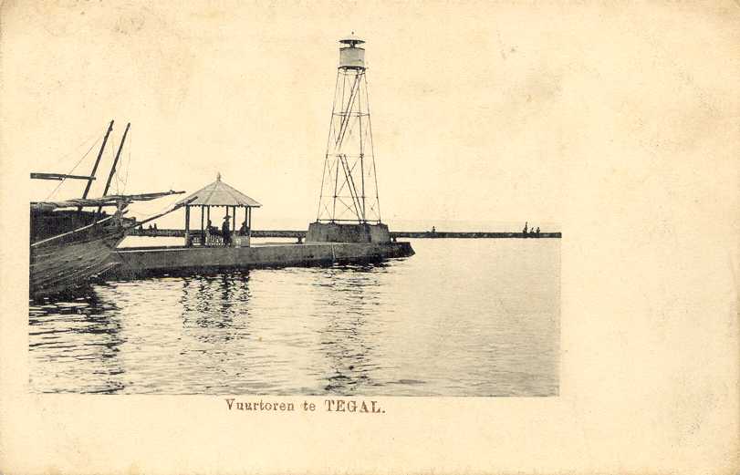
- * Tegal (Rede Tegal) (2)
- Date unknown (station established 1880). Active; focal plane 32 m (105 ft); white light, 5 s on, 5 s off. 30 m (98 ft) square skeletal tower, painted white. No photo available, but the tower is seen in a Google satellite view. Huelse has a postcard view of the original Dutch lighthouse. Located at the harbor of Tegal, a minor port about 25 km (15 mi) west of Pemalang. Site open, tower closed. ARLHS IDO-263; Admiralty K1105; NGA 23504.
- * Pekalongan (2)
- Date unknown (station established 1866). Active; focal plane 14 m (46 ft); white flash every 5 s. 14 m (46 ft) round hourglass-shaped tower. Entire lighthouse is white. A photo is available. This tower replaced a skeletal tower. Located on the waterfront at Pekalongan, about 70 km (45 mi) west of Semarang. Site open, tower closed. ARLHS IDO-186; Admiralty K1122; NGA 23532.
- * Tanjung Celong
- Date unknown. Active; focal plane 30 m (98 ft); white flash every 4 s. Described by NGA only as a "white beacon," but a distant Google satellite view probably shows the base of a square skeletal tower, painted white. No photo available. Located on the east side of an estuary entrance at Gempolsewu. Site probably open, tower closed. ARLHS IDO-299; Admiralty K1128; NGA 23539.
- Pulau Njamuk (Pulau Nyamuk, Mosquito Island)
- Date unknown. Active; focal plane 30 m (98 ft); three white flashes every 15 s. 30 m (98 ft) skeletal tower, painted white. No photo available, and Google has only a very distant satellite view of the island. Located on a small island at the western end of the Karimunjawa group, about 130 km (80 mi) north northwest of Semarang. Accessible only by boat. Site status unknown. ARLHS IDO-073; Admiralty K1140; NGA 23568.
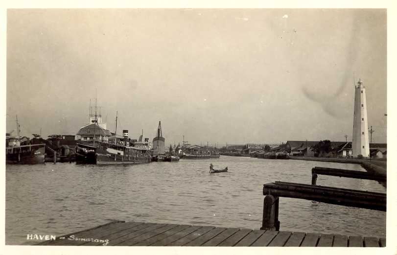
- * Semarang (Tanjung Emmas) (2)
- 1883 (station established 1872). Active; focal plane 33 m (108 ft); four white flashes every 20 s. 30 m (98 ft) 12-sided cast iron tower with lantern and gallery. Entire lighthouse painted white. A photo is at right, a good closeup photo and a 2008 photo are available, KITLV has a 1910 photo, Huelse has a historicpostcard view, and Google has a satellite view. Located on a promontory on the east side of the harbor of Semarang, a major port of central north Java. Site open, tower closed. ARLHS IDO-040; Admiralty K1132; NGA 23560.
- Jepara (Djapara)
- Date unknown (station established 1908). Active; focal plane 17 m (56 ft); white flash every 3 s. 15 m (49 ft) white concrete post light with double gallery. Hadi Bindowi has a distant view, and Google has a satellite view. Jepara is a small port on Java's northern peninsula, about 55 km (35 mi) north of Semarang. Site status unknown. ARLHS IDO-356; Admiralty K1139; NGA 23580.
- Pulau Mandalika (Mondoliko)
- Date unknown (station established 1887). Active; focal plane 86 m (282 ft); white flash every 5 s. 16 m (52 ft) hexagonal skeletal tower with lantern and gallery, painted white. The light is barely discernible in a distant view of the island, KITLV has a 1920 photo of the present lighthouse, and Google has a fuzzy satellite view of the station. Pulau Mandalika is a small island off the tip of Java's northern peninsula. Located at the highest point of the island. Accessible only by boat. Site status unknown. ARLHS IDO-224; Admiralty K1144; NGA 23572.
East Java Province: Madura Lighthouses
Note: Madura is a large island off the northeastern coast of Java. The island is roughly 130 km (80 mi) long east to west and up to 35 km (22 mi) wide. It is separated from Java by the Madura Strait. At its western end, the strait is quite narrow and is crossed by the 5.4 km (3.4 mi) long Suramadu Bridge. On the south side of Madura, however, the strait is a broad sound up to 80 km (50 mi) wide. Madura has a population of roughly 4 million.- *** Sembilangan (Ujung Slempit) (Range Rear) (2)
- 1882. Active; focal plane 53 m (174 ft: two white flashes every 10 s. 50 m (164 ft) 12(?)-sided cast iron tower with lantern and gallery. Entire lighthouse painted white. Indomarinav's photo is at right, Haryono Cokro has a 2008 photo, another photo is available, Satria Perkasa has a distant view, KITLV has a1913 photo, the Tropenmusuem has a historic photo, and Google has a good satellite view. A portfolio of 2010 photos shows eveidnece of recent restoration work. Located on Semibilangan island off the extreme western tip of Madura, this is both a landfall light and the rear light of a range guiding ships into the channel between Madura and Java to approach the port of Surabaya. Accessible by road from Bangkalan, Madura. Site open, tower open although we do not know the schedule. ARLHS IDO-079; Admiralty K1158.2; NGA 23624.
- Karang Djamuang (Jamuang)
- 1971. Active; focal plane 41 m (135 ft); white flash every 4 s. 40 m (131 ft) skeletal tower, painted white. No photo available, but Google has a satellite view. Located on a small island at the northeastern entrance to the Madura Strait about 13 km (8 mi) north of Bangkalan. Accessible only by boat. Site status unknown. ARLHS IDO-065; Admiralty K1162; NGA 23612.
- Masalembo Besar
- Date unknown. Active; focal plane 200 m (656 ft); three white flashes every 21.5 s. 40 m (131 ft) skeletal tower, painted white. No photo available. Located atop a small island in the middle of the Java Sea about 160 km (100 mi) northeast of Madura. Accessible only by boat. Site status unknown. ARLHS IDO-011; Admiralty K1424; NGA 23592.
- Pulau Sapudi (Sapoedi) {Trebung}
- 1887. Active; focal plane 59 m (194 ft); white flash every 5 s. 58 m (190 ft) octagonal skeletal cast iron tower with lantern, gallery, enclosed watch room, and central cylinder. Entire lighthouse painted white. A distant 2008 photo is available; the Tropenmuseum has a historic photo, and KITLV has a partialview taken in 1911, but Google's satellite view has no detail in this area. Located at the west point of Sapudi, an island lying to the east of Madura. Site status unknown. ARLHS IDO-091; Admiralty K1240; NGA 23744.
- Gili Raja
- Date unknown. Active; focal plane 42 m (138 ft); white flash every 6 s. Approx. 35 m (115 ft) square tower, painted white. No photo available, but Google has a satellite view. Gili Raja is an inhabited island in the Madura Strait off the southeastern coast of Madura. Located at the east end of the island. Site status unknown. ARLHS IDO-090; Admiralty K1228; NGA 23718.
- * Camplong
- Date unknown. Active; focal plane 21 m (69 ft); four white flashes every 20 s. 19 m (62 ft) square skeletal tower with gallery, covered by white metal panels. A distant view is available, and Google has a satellite view. Located near an oil terminal at Camplong, on the central south coast of Madura. Site open, tower closed. ARLHS IDO-089; Admiralty K1225; NGA 23714.
- Karang Koko (Madura Strait, Zwaantjes Reef) {Zwaantjes Droogte} (2)
- Date unknown (station established 1871). Active; focal plane 18 m (59 ft); three white flashes every 13 s. 16 m (52 ft) iron tower, mounted on a round pier. Lighthouse painted white. No photo available. Michel Forand has a historic photo of the original Dutch lighthouse. Located on a dangerous reef in the Madura Strait about 25 km (15 mi) northeast of Pasuruan. Accessible only by boat. Site open, tower closed. ARLHS IDO-145; Admiralty K1200; NGA 23676.
East Java Province: Mainland North Coast Lighthouses- * Probolinggo West Mole (Tanjung Tembaga)
- Date unknown. Active; focal plane 15 m (49 ft); green flash every 5 s. 14 m (46 ft) round hourglass-shaped tower, painted green. A photo is available, and Google has a satellite view. Located at the end of the west mole at Probolinggo, on the southwest side of Madura Strait. Accessible by walking then mole. Site open, tower closed. ARLHS IDO-188; Admiralty K1212; NGA 23692.
- * Panarukan
- Date unknown (station established 1880). Active; focal plane 15 m (49 ft); white flash every 3 s. 14 m (46 ft) skeletal tower, painted with black and white horizontal bands. No photo available, and the tower has not been located in Google's satellite view of the port. KITLV has a 1930 photo of the original lighthouse, which may possibly survive. Located in Panarukan, a fishing port about 10 km (6 mi) west of Situbondo. Site status unknown, probably open. ARLHS IDO-184; Admiralty K1220; NGA 23708.
- * Jangkar
- Date unknown. Active; focal plane about 21 m (69 ft); light characteristic unknown. Approx. 18 m (59 ft) square skeletal tower with gallery, painted white. A photo is available, and Google has a satellite view. Located on the waterfront at Jangkar, a town about 25 km (15 mi) east of Situbondo. Site open, tower closed.
East Java Province: Bali Strait Lighthouses
Note: The Bali Strait separates Java from the smaller island of Bali to the east, connecting the Indian Ocean to the Bali Sea. The strait narrows northward to a width of only 2.4 km (1.5 mi) at its northern end.- Tanjung Candiban
- Date unknown. Active; focal plane 60 m (197 ft); white flash every 3 s. This lighthouse is described by NGA only as a "white beacon." No photo available, but a Google satellite view reveals what is probably a square skeletal tower with lantern and gallery roughly 30 m (98 ft) in height. Located at the northeastern tip of Java, overlooking the Bali Sea. Accessible by road. Site status unknown. ARLHS IDO-096; Admiralty K1224; NGA 23773.
- Pulau Tabuan {Duiven Eiland} (2)
- Date unknown (station established 1871). Active; focal plane 17 m (56 ft); white flash every 5 s. Approx. 14 m (46 ft) round hourglass-shaped white fiberglass tower. Joe Sata Pradana has a view from the sea, and Google has a satellite view. The Tropenmuseum has a historic photo of the original lighthouse, a skeletal tower with lantern and gallery. Located on a small island marking the west side of the northern entrance to the Bali Strait, at the eastern end of Java. Accessible only by boat. Site open, tower closed. Admiralty K1249; NGA 23774.
- Tanjung Sambulungan
- Date unknown. Active; focal plane 19 m (62 ft); white flash every 3 s. Described by NGA as a "white beacon"; a Google satellite view reveals an approx. 14 m (46 ft) white concrete post light with gallery, probably rising from a square equipment shelter. Located near the end of a long, north-pointing, densely-forested peninsula that shelters the Java coast in the southern portion of the Bali Strait. Probably accessible only by boat. Admiralty K1261; NGA 23806.
East Java Province: South Coast Lighthouses
Bedadung (Watangan)- Date unknown. Active; focal plane 42 m (138 ft); white flash every 4 s. Approx. 35 m (115 ft) tapered square skeletal tower with gallery, painted white. 1-story keeper's house. NGA provides no description of this lighthouse, but a closeup photo is at right, and Google has a good satellite view. Located near the beach at Puger, about 40 km (25 mi) southwest of Jember. Site status unknown. Admiralty K1261.5; NGA 23821.
- Ujung Siklapa (Teluk Segoro Wegi)
- Date unknown. Active; focal plane 51 m (167 ft); white flash every 3 s. NGA provides no description of this lighthouse, but a Google satellite view reveals a white concrete tower of unknown height. Located on a promontory about 30 km (19 mi) south of Durenan. May be accessible only by boat. Site status unknown. Admiralty K1262.5; NGA 23821.3.
- Pacitan (Patjitan)
- Date unknown. Active; focal plane 50 m (164 ft); white flash every 5 s. This lighthouse is described by NGA only as a "white beacon." No photo available, but a Google satellite view reveals what is probably a square skeletal tower with lantern and gallery roughly 30 m (98 ft) in height. Located on a promontory on the east side of the entrance to the circular harbor of Pacitan. Site status unknown. Admiralty K1262.8; NGA 23821.5.
Jogjakarta Province Lighthouse
* Pantai Dan (Pandansari, Kali Opak)- Date unknown (apparently since 1998). Active; focal plane 44 m (144 ft); white flash every 4 s. Approx. 38 m (125 ft) octagonal concrete tower with lantern and gallery. The tower appears to be unpainted white concrete. Six keeper's houses and other buildings. Sudut Piksel Gue has a 2008 closeup photo, Satrio Tan has a 2008 photo, additional photos are available, a Jogjakarta tourist site has a page for the lighthouse, and Google has a satellite view. Located on the south coast of Java about 30 km (19 mi) south of Jogjakarta. Site status unknown. Admiralty K1264.5; NGA 23821.9.
Central Java Province South Coast Lighthouses
* Klirong- Date unknown. Active; focal plane 42 m (138 ft); white flash every 5 s. Approx. 35 m (115 ft) square tapered pyramidal steel skeletal tower with lantern and gallery, painted white. A photo is available, but Google has a satellite view. The tower is very similar to the Bedadung Light shown above. This lighthouse is in a well-populated area, but it is not on any route likely to be taken by tourists. Located near the coast about 20 km (13 mi) south of Kebumen. Site probably open, tower closed. Admiralty K1276.2; NGA 23822.4.
- Teluk Penyu Entrance Range Front
- Date unknown. Active; focal plane 17 m (56 ft); white light, 2 s on, 2 s off. 17 m (56 ft) square tower, mounted on a square pier supported by piles. Presumably very similar to the rear range light (Next entry). No photo available, but Google has a satellite view. Located in the water about 500 m (0.3 mi) east of the rear light. Accessible only by boat. Site open, tower closed. ARLHS IDO-085; Admiralty K1270.1; NGA 23828.
- * Teluk Penyu Entrance Range Rear
- 2007(?). Active; focal plane 23 m (79 ft); white light, 1 s on, 1 s off. 22 m (72 ft) square skeletal tower, covered with white metal panels. A photo and a second photo are available, and Google has a good satellite view. In Erwin Hanafi's 2009 photo, the upper panels are missing and the red skeletal structure of the tower is visible; however, this photo may show a different lighthouse. Located on the beach at the Teluk Penyu (Penyu Bay oil terminal near Cilacap. Site apparently open, tower closed. Admiralty K1270.11; NGA 23832.
- Teluk Penyu Second Range Front
- Date unknown. Active; focal plane 17 m (56 ft); white light, 2 s on, 2 s off. 17 m (56 ft) square tower, mounted on a square pier supported by piles. Presumably very similar to the rear range light (Next entry). Soga Soegiarto has a photo, Ahmad Fuad Hasan has a view from the beach, and Google has a satellite view. Located in the water about 2 km (1.2 mi) southeast of the Entrance Range Front Light. Accessible only by boat. Site open, tower closed. Admiralty K1272; NGA 23836.
- * Teluk Penyu Second Range Rear
- 2007(?). Active; focal plane 23 m (79 ft); white light, 1 s on, 1 s off. 22 m (72 ft) square skeletal tower, covered with white metal panels. No closeup photo available; a distant view shows both range lights, and Google has a good satellite view. Located on the beach at the Teluk Penyu (Penyu Bay oil terminal near Cilacap. Site apparently open, tower closed. Admiralty K1272.1; NGA 23840.
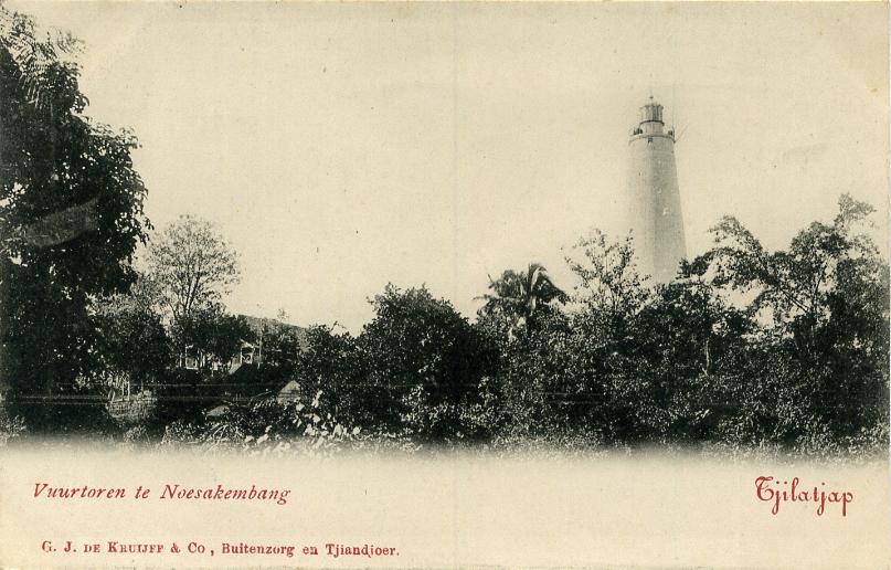
- * Cimiring (Cilacap, Tjilatjap, Noesa Kambangan)
- 1870. Active; focal plane 178 m (584 ft); white flash every 5.5 s. 32 m (105 ft) round stone tower with lantern and gallery, painted white. KITLV has a historic photo, the Tropenmuseum has the same photo, Huelse has a historic postcard view, and Google has a satellite view. No current photo available, but Sadie Paulus has a photo of the view from the lighthouse. Located at the east end of the island of Kambangan, marking the entrance to the port of Cilacap on Java's south coast. Site apparently open, tower closed. ARLHS IDO-060; Admiralty K1268; NGA 23824.
West Java Province South Coast Lighthouse
Pulau Manuk (Manuk Island)- Date unknown. Active; focal plane 50 m (164 ft); two white flashes every 10 s. 30 m (98 ft) "beacon tower," painted white. No photo available, and Google has only a fuzzy satellite view of the area. Not to be confused with a much better known Pulau Manuk, a wildlife reserve farther west, near the Sunda Strait. Located on an island just off the coast about 20 km (13 mi) southwest of Cijulang. Accessible only by boat. Site status unknown. Admiralty K1277.5; NGA 23870.5.
 Cikoneng (Anyer) Light; Indomarinav photo |
 Jakarta West Mole Light; Jakarta Fish Port image |

 Sembilangan Light; Indomarinav photo |

Information available on lost lighthouses:
- Grisek (Gresik) (1882-?), Grisek, near Surabaya
- Juana (Djuana, Juwana) (1910-?), Juwana, Central Java north coast.
- Pasuruan (1880-?), Pasuruan, south of Surabaya
- Tanjung Priok Mole (1884-?), Jakarta
Notable faux lighthouses:
- Perak Harbor, Surabaya. Though often described as a lighthouse, this building never carried a light; it was probably the harbormaster's office.
No comments:
Post a Comment