
YB6ABO/P, YC1BIQ/6, YD0AVE/6, YE1AR/6
OC-245, Rondo Island , NEW Island
IDO-369 Rondo LightHouse, NEW LH
January 20 - 27, 2022
6° 4' 24.2646' S, 95° 7' 4.764" E, Grid NJ76nb CQ28 ITU54


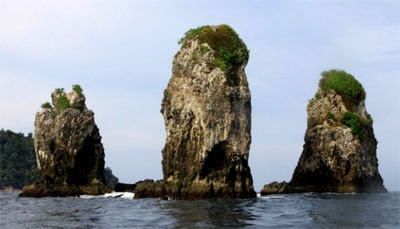
India's southernmost territory (Indira Point) on Great Nicobar Island of the Nicobar Islands is approximately 84 miles or 135 km to the north from the Indonesia's northernmost territory on Rondo Island.[5][2] Centered 21 km or 13 mile northwest of Rondo, between Indonesia and India, there is a submerged sandy and rocky coral shoal with a least depth of 51 m.[3][4] Island is surrounded by a mile (1.7 km) wide reef which has steep marine slope on its edges.[3][4] On the southern edge of island's reef there are small rocky islets,[3][4] 14 in total lying at a distance between 0.9 to 1.7 km. Between these islets and Weh Island there is 16-20 km or 3-3.5 leagues wide safe navigable channel.[5] Before the advent of modern shipping, the shipping between Rondo and Weh Islands was considered safer due to calmer seas.[6]
Rondo island, nicknamed as "Guardian of Indonesia",[7] bordering exclusive economic zones of India and Thailand, lies on the strategically important shipping route where commercial shipping vessels from and to Indian Ocean pass north of Rondo.[2][3][4] India and Indonesia are upgrading the Sabang deepsea port under their strategic economic and military partnership to enhance the regional connectivity, safety, security, and to protect the Andaman Sea and Strait of Malacca channel between Great Nicobar Island and Rondo Island (c. 2019).[8] Area around Rondo Island is known for the threat of piracy.[9]

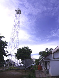
Equipment
YB6ABO/P, YC1BIQ/6, YD0AVE/6, YE1AR/6
Radio TS-570, FT-450, IC-718,
Antenna Vertical 43 feet, Slooper Dipole 160M and 80M
Mode mainly on FT8 as well as on CW n SSB
Mode mainly on FT8 as well as on CW n SSB
QRV 10m - 160m band
QSL Info :
special qsl card design for dxpedition will be issued
YE1AR/6
OQRS via YE1AR Clublog
OQRS via YE1AR Clublog
QSM via N2OO Bob Schenck
Donation
please use ye1ar@yahoo.com for Paypal account

Personal Sponsor Rondo Island : W5GAI, YC1AYO
No comments:
Post a Comment